All Activity
- Past hour
-

2026-2027 Record-breaking El Nino
FPizz replied to Stormchaserchuck1's topic in Weather Forecasting and Discussion
Who the hell do you follow to see those claims and why do you still follow them? I haven't seen any of the sort. I feel like you see it from one person then act like all of twitter is posting that. -

2026-2027 Record-breaking El Nino
michsnowfreak replied to Stormchaserchuck1's topic in Weather Forecasting and Discussion
100%. Completely ignoring how weather patterns work because the earth is warming is a complete disservice to meteorology, and most here know that, so the trolls continue to look foolish. The obsession is strictly over a seasonal (or annual) mean which totally ignores day to day, week to week weather. Why even bother with the hobby then? I just ran the #s out of curiosity, knowing the spell of mild winters we had in the 1930s-50s, and sure enough, Detroit has averaged MORE below zero days in the 2000s, 2010s, and 2020s than in the 1930s, 1940s, or 1950s. Wanna grasp at a straw that the site has changed over the years, then use nearby Ann Arbor. They have been at U of M site unchanged since 1880...and they too saw significantly more below zero days in the 2000s-2020s than the 1930s-1950s. -
Guess it makes sense that if you keep increasing poleward heat fluxes you'll start to mess with the polar vortex more. No clue how that plays onto the rest of winter but I'll ask my climatology professor about it tomorrow.
-

2026-2027 Record-breaking El Nino
soadforecasterx replied to Stormchaserchuck1's topic in Weather Forecasting and Discussion
Based off this chart really looks like we have our best shot at seeing a positive PDO since the 15/16 season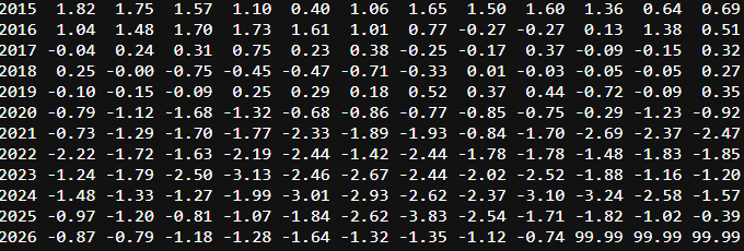
-
2026-2027 Record-breaking El Nino
LakePaste25 replied to Stormchaserchuck1's topic in Weather Forecasting and Discussion
My peak of +3.2-3.7 RONI and +3.7-4.2 ONI prediction I made a couple of months ago is looking alright. Might have even gone a little too low. -
Yep and the 70's that are showing up across much of the lower 48 this week get more and more compressed next week and completely disappear except for Florida and parts of the SW by the second week of November.
-
 legitimate canadian pharmacy or canadian pharmacy service pharmacies in canada that ship to the us https://cse.google.com.gt/url?sa=t&url=https://canpointerx.com pharmacies in canada that ship to the usand http://ussher.org.uk/user/kqyagqusnm/?um_action=edit reliable canadian pharmacy [url=https://www.google.com.lb/url?q=https://canpointerx.com]certified canadian pharmacy[/url] canada rx pharmacyor [url=http://lenhong.fr/user/tzofrjlnto/]canada drug pharmacy[/url] canada online pharmacy
-

2026-2027 Record-breaking El Nino
bluewave replied to Stormchaserchuck1's topic in Weather Forecasting and Discussion
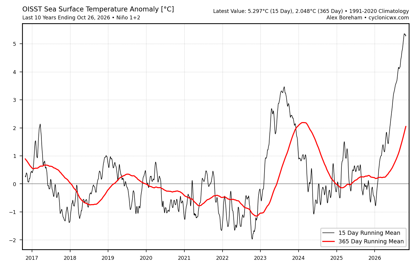
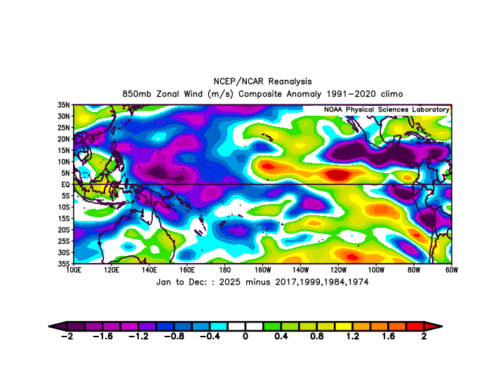
It’s as if these two super El Niño are linked together through some shared underlying mechanism since the Nino 1+2 365 day mean SSTs never dropped below neutral following 2023-2024. The trades also didn’t fully returned to normal north of the equator in the ENSO regions over the same period. Much different than all the previous super El Niño events of the past.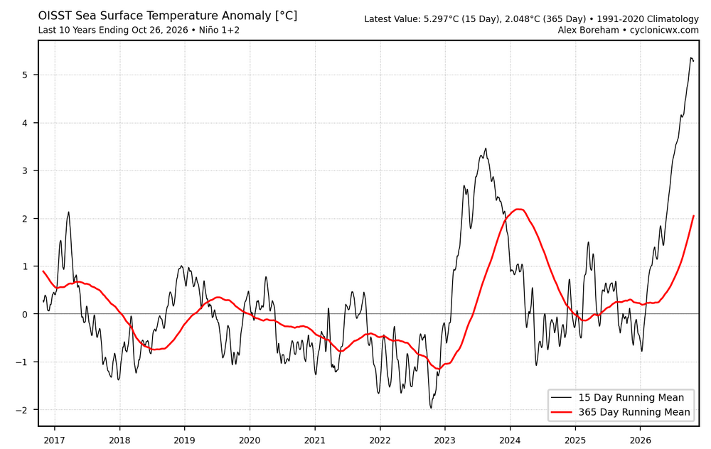
-
legitimate canadian pharmacy or canadian pharmacy service pharmacies in canada that ship to the us https://cse.google.com.gt/url?sa=t&url=https://canpointerx.com pharmacies in canada that ship to the usand http://ussher.org.uk/user/kqyagqusnm/?um_action=edit reliable canadian pharmacy [url=https://www.google.com.lb/url?q=https://canpointerx.com]certified canadian pharmacy[/url] canada rx pharmacyor [url=http://lenhong.fr/user/tzofrjlnto/]canada drug pharmacy[/url] canada online pharmacy
-
From a local Met who I highly respect and has a great track record. Good read for those interested in this aspect of Meteorology/Climatology: "**Weather Nerd Alert: Unprecedented El Nino Arrives…Polar Vortex Says, “Hold My Beer!”** *Short Version: A strong El Nino is dominating the global weather pattern and keeping us mild here at home. However, a major disturbance in the polar vortex could shift the pattern towards cold and snow before November ends, and leave a lasting impact on the winter overall. *Detailed Version: Buckle up folks, this is going to be interesting to watch. We have not 1, but 2 unprecedented global weather patterns that are about to overlap and nobody knows exactly how this will play out across the US. El Nino is currently near or possibly at record levels currently. This El Nino is also likely to peak over the next 2 months before a slow/gradual weakening late in the winter. I have mentioned repeatedly that strong El Ninos generally lead to warmer than normal temperatures overall for the Great Lakes region with below normal snowfall, AND that the Polar Vortex can enhance that pattern or modify the effects. Well as it turns out, the Polar Vortex is doing something unprecedented on its own that could have a major impact on not only the winter, but also late fall. A Sudden Stratospheric Warming (SSW) event is likely to occur next month. We are already seeing the early signs of this playing out and our computer models are all in sync showing this evolving during the first part of November. These events used to be rare occurring once every other year on average. However, they are becoming more common in late January through March. They are very rare in December and essentially unheard of in November. A SSW is a sudden warming that occurs in the stratosphere above the North Pole. This does not impact the weather at the ground, at least it doesn’t initially. The warming high above the North Pole triggers a domino effect. This weakens the Polar Vortex and that allows a more amplified jet stream and Arctic air to shift away from the North Pole. It sets the stage for Arctic Outbreaks and snow. It can take a couple of weeks for us to feel any impact from a SSW, but once the weak Polar Vortex develops, it can influence the weather pattern for 2-6 weeks on average. It may also set the stage for the coming winter pattern. So what does that mean for us in the short term and for the winter overall? Well, as I said to start off this post, nobody knows for sure. We are about to see two unprecedented events overlap at the same time. I am a student of weather history, but I don’t have a data set I can refer to in this scenario. The closest match is the winter of 2009-10. That winter we had a moderate to strong El Nino (just not nearly as strong as this season), and we did have a Polar Vortex disturbance in mid to late November (though not to the extent of this year). The result was a warm end to October and a warm November, but a quick flip to cold and snow in December. The winter was back and forth, but overall, we ended up with near normal snowfall to slightly above normal (about 40” for the winter). 1968-69 is the next closest match, but that El Nino was weaker and the Polar Vortex disturbance was weak. With that said, November started with near record warmth and bounced back and forth between warmth and snow before Thanksgiving, but winter locked in between Thanksgiving and Christmas. Early January was harsh with cold and snow, then winter flipped back towards warmth the rest of the season. Overall snowfall was below normal at 28”. Computer models are much warmer than normal to start off November. They do not show any significant pushes of cold air right now in the middle to later part of November. However, models are not reliable at all during that time period either. Based on the information we have right now, I suspect we will see a bigger pattern flip towards cold and possibly snow in the 2nd half of November. Thanksgiving to Christmas could be a colder and snowier time period with big ups and downs the rest of the winter. Odds still favor a warmer than normal winter with below normal to near normal snowfall. With that said, we are dealing with uncharted territory here. I will keep you updated as we navigate the new data in the weeks ahead."
-

2026-2027 Record-breaking El Nino
GaWx replied to Stormchaserchuck1's topic in Weather Forecasting and Discussion
The official NOAA Nino weekly (based on OISSTv2.1) was at +2.5 for the avg of last week and is likely ~+2.6 now. Based on this as well as forecasts, I’m currently thinking their weeklies will likely peak no higher than low +3’s, which means monthlies will likely peak no higher than ~+3.0. That would mean a trimonthly RONI peak probably in the upper +2.0s. -
 The only other time in recorded history we had 5/6 La nina years, we didn't have another La Nina for 7 years following that. And the PDO switched to positive in that time. 20-26 we again had 5/6 La Nina's, so the reversal was not that surprising imo.
-
Met4Cast - UK Weather @Met4CastUK The likelihood of the earliest major sudden stratospheric warning on record is increasing for early November. 67.7% of the GEFS show zonal winds reversing while 86.3% of the ECM ensembles show a reversal. The current earliest reversal on record is November 28th in 1968.
- Today
-

2026-2027 Record-breaking El Nino
roardog replied to Stormchaserchuck1's topic in Weather Forecasting and Discussion
The ONI ended up borderline super probably because of all the warm water available but the other indices weren’t nearly that strong. This is where ONI skews the results IMO. If you look at that Nino more as a moderate to high end moderate then this super Nino isn’t as surprising as it seemed early this year. -
DT is sounding the bell regarding the SSWE and its never-seen-before timing in a Super El Nino setup. I guess that means the QBO plots should be crashing at some point on the horizon?
-
If we do get cross polar flow later in November this might move into Canada and then move SE based on a - AO regime. FLXweather-Dave @FXweather26823 In the U.S, we tend to focus on northern Canada for the annual rebuilding of cold air in the Fall, but Siberia is the true cold air factory, and it's producing a surplus right now. Much colder than normal air has spread all the way to, and beyond, the Mongolia & China border.
-

2026-2027 Record-breaking El Nino
snowman19 replied to Stormchaserchuck1's topic in Weather Forecasting and Discussion
Traditional ONI: almost +3.5C RONI: +2.9C The EURO has been dead balls accurate with this event. The over +4C peak it shows for December is not only believable, it’s very likely. Also, the subsurface warming continues. My final call is a December peak of +4.0C - +4.1C (traditional ONI) and +3.5C - +3.6C (RONI). I think the subsurface peaks next month at +13C -
I am starting to get interested now. https://x.com/griteater/status/2115136878211223702 griteater @griteater Such a stable looking GFS run with the SSW (shown here at 30mb). Model runs will vacillate, but this one was a biggie with a SSW on Nov 4 still going at Nov 13
-

2026-2027 Record-breaking El Nino
40/70 Benchmark replied to Stormchaserchuck1's topic in Weather Forecasting and Discussion
I know it sounds cliche, but awful forecasts are the best learning tools....it's all about perspective. You just have to own it and approach with an open mind. -
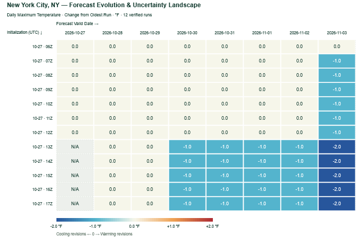
The most recent NBM cycles have grown slightly cooler for the start of November. Nevertheless, readings remain well above average.
-
This October pattern is a near repeat of the one from two years ago when we hit 80°F on Halloween and then again on the 5th of November. I don't know if this will be the warmest October ever, but it will likely have the most >60°F days with all but one day exceeding that high. The 17th ruined a possible perfect score with a high of 53°F. La Nina vs. El Nino doesn't seem to make a difference there. Welcome to extended summer.
-

2026-2027 Record-breaking El Nino
OSUmetstud replied to Stormchaserchuck1's topic in Weather Forecasting and Discussion
Cohen man idk. That dude is always forecasting big snow lols. -

2026-2027 Record-breaking El Nino
forkyfork replied to Stormchaserchuck1's topic in Weather Forecasting and Discussion
weenied for being right -

2026-2027 Record-breaking El Nino
Typhoon Tip replied to Stormchaserchuck1's topic in Weather Forecasting and Discussion
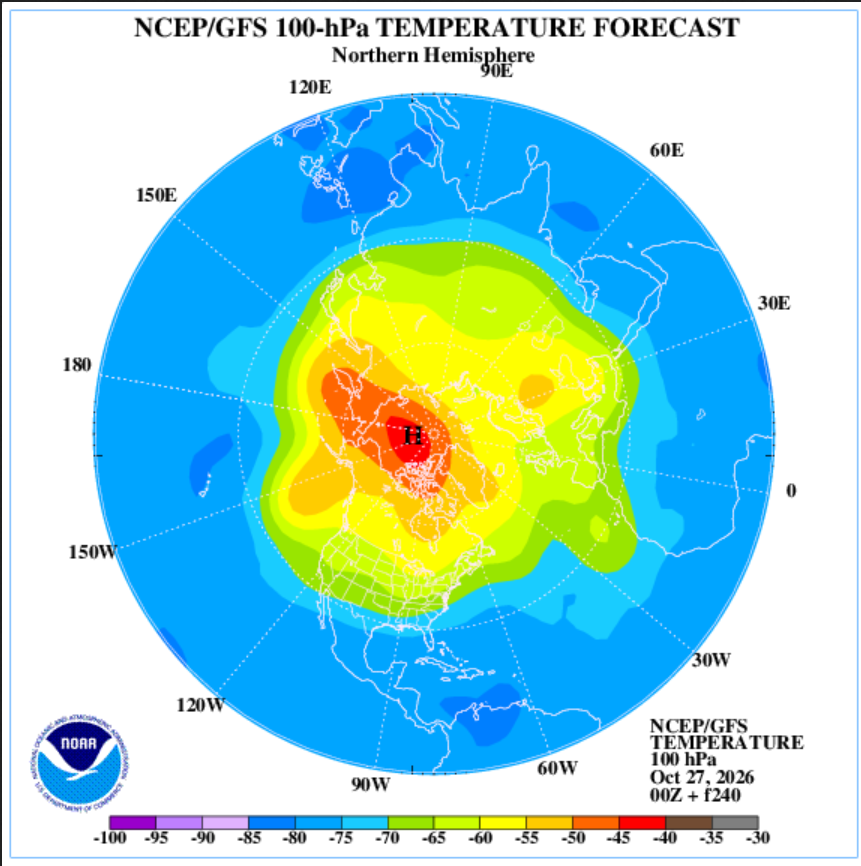
Don't have much time today; just wanna get this out there before I forgotted, as my niece would say- This is likely to physically stress the PV, below. It's the 100 hPa level thermal anomaly centered on D10 off 00z last night, over at the strat-trop monitoring office. Said stressing would likely respond a -AO index as we age on thru the first week of November. This may be what the background soc-media chorus is singing about? Not sure, but this did not have an origin from an SSW event. Just so's that's noted. as I was mentioning to Ray yesterday, it won't make much difference. Timing perhaps. But whether there's an SSW --> -AO (after 20 day lag) or something going on from bottom --> up ( which this appears to be...), there is likely to be a -AO response of some kind in either case. SO, I'm not hugely put off by anyone that thinks it's SSW but just sayn' That's impressive there tho... It's actually in place already as of the initialization last night, but is amplifying out in time. I checked the rotated PCP analysis version and the AO is in fact crashing to about -.5 by Novie 7 or so. The same source - btw- also depicts the PNA rising to an impressive +1.5 to almost 2 SD... We'll see where the hemispheric conveyors set up on the AO stuff but that PNA is a mode change.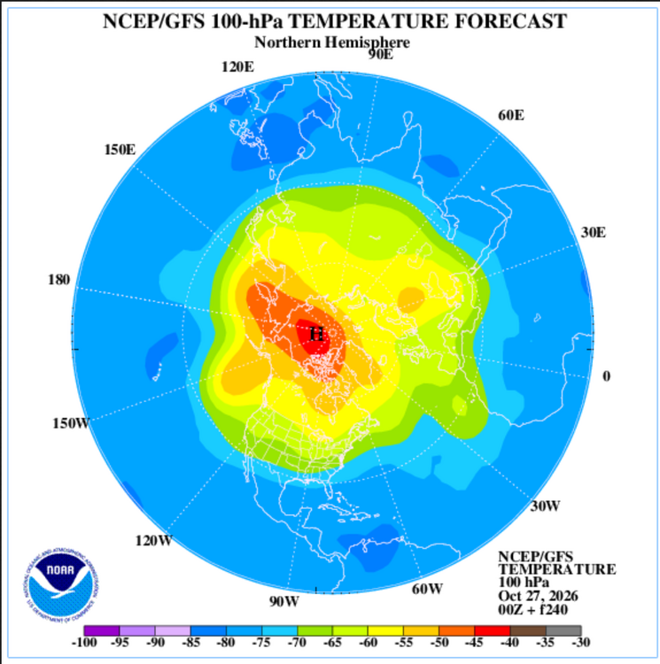
-
People start looking for winter earlier every year…and when it doesn’t show up in late October, well winter gets cancelled.