All Activity
- Past hour
-

December 2025 Short/Medium Range Forecast Thread
Carvers Gap replied to John1122's topic in Tennessee Valley
There is a noticeable and significant uptick in juice w/ the 18z short range models w/ regards to Sunday night. The GFS continues w/ its outlier look in NE TN, but the 12z NAM has the same deformation band. Almost all short range models now have increased backing over Virginia and/or North Carolina. Can it get west of the Apps??? I don't know about that. -
18z GFS shifts north with possible Monday snow.
-
Totally agree with you. It all started with every event after November 2018. I never remember it before that and vividly remember it after that! 100%
-
Lol this is the truth! The Valley cashes in on synoptic storms but when the freaking low rides the coast like last year it's crap. Us mountain communities are way different from even Buncombe, Hendersonville, and out away from the border.
-
Snippet from Mount Holly AFD- While technically outside the current forecast period, it should be noted that an arctic outbreak with well below normal temperatures looks to be on the horizon beginning next weekend. A few consecutive days of temperatures on the order of 10-20 degrees below normal are possible.
-
I hear ya and don’t necessarily disagree. But they aren’t invasive (aggressive) and don’t spread their seed far so a single tree isn’t really hurting the ecosystem much. If I could only plant a couple of trees it would be native ones, but if I had a large enough property and more room for trees than I knew what to do with I’d possibly plant one. They’re fairly useless for wildlife though.
-
Euro Ens hinting at a possible wave preceding/along the Arctic front end of next week into the weekend. Maybe a shot of snow followed by H5 Avocado/surface Barney cold.
-
Another cold rainy day here. Only picked up .11" and the high was 45.
-
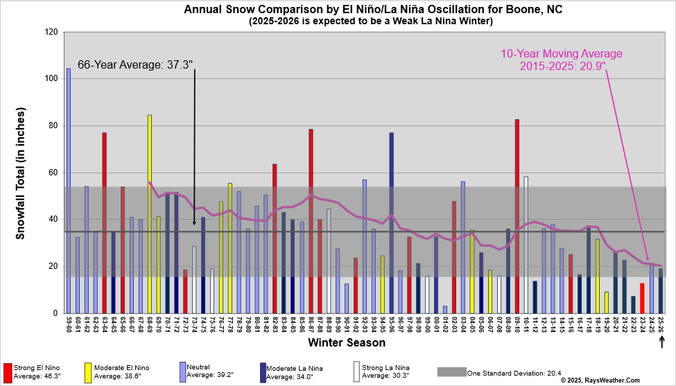
Yeah everyone is above average even Boone..
-

2025-2026 Fall/Winter Mountain Thread
BlueRidgeFolklore replied to Buckethead's topic in Southeastern States
Every community in the French Broad River valley is in a shitty place for snow. Haha. At the very least, Henderson County performs better with CAD events than it’s NWF counterparts. -
 This morning's snowfall totals: Bridgeport: Trace Central Park: Trace LaGuardia Airport: Trace Newark: 0.1"
 -
One county over to the left of the black box of death is me. lol .
-
Asheville isn't above average that's for sure. They are as much below as the foothills. As are most of the Blue Ridge escarpment mountains. Closer to the smokies and TN border maybe average due to NW flow mostly. Synoptic snows are way below average
-
new england music
-
Parts of the region received dustings and even coatings from bursts of light snow that fell overnight into the early morning due to pockets of instability. Newark picked up 0.1". The weekend will end on an unseasonably cool note. A fresh surge of cold air will arrive tomorrow night. Monday will likely see subfreezing temperatures across much of the region and Tuesday morning could rival or even surpass the cold of December 5th. The ongoing stretch of below normal temperatures will likely continue into or through the second week of December. December 1-10 will be a solidly colder than normal period. The potential exists for the coldest first 10 days of December since at least 2007 (33.4°, 5th coldest December 1-10 since 2000). The five coldest December 1-10 periods since 2000 were: 1. 30.6°, 2002 2. 32.2°, 2003 3. 32.4°, 2000 4. 33.1°, 2005 5. 33.4°, 2007 All 5 of these cases had measurable snowfall in Central Park. The WPO is forecast to become strongly negative beyond December 10th. That would likely contribute to the December 10-20 period also being colder to perhaps much colder than normal. The probability that December 2025 will have a maximum monthly temperature below 60° is increasing. The last time that happened was in 2019 when the monthly high was 58°. If 2025 has a monthly high below 60°, that would be only the fifth such occurrence since 2000 (2003, 2004, 2005, and 2019 are the cases since 2000). The ENSO Region 1+2 anomaly was -0.1°C and the Region 3.4 anomaly was -0.6°C for the week centered around November 26. For the past six weeks, the ENSO Region 1+2 anomaly has averaged -0.18°C and the ENSO Region 3.4 anomaly has averaged -0.67°C. La Niña conditions will likely continue through at least mid-winter. The SOI was -23.41 today. The preliminary Arctic Oscillation (AO) was -1.756 today.
-
If I didn’t know any better I’d be expecting a regionwide 8-12” out of this.
-
NAMed
-
non native. cut them all down
-
Liability, amplified after the cluster that the states and city had post-November 2018. It had been steadily getting worse, and their slow response to 2018 made them go HAM for everything thereafter. .
-

2025-2026 Fall/Winter Mountain Thread
ncjoaquin replied to Buckethead's topic in Southeastern States
Good point about the airport location. I have thought that for years! Actually, an excellent point.I have had more than them, but we have definitely not seen as much as you border guys. I used to cash in better on NW flow events, but that has been way lower lately. We are definitely substantially below normal. But, we have had some snow, which beats what a lot of people have had. I have complained some, but for the most part, I will just wait for the next one. Plus, I am a short drive away to see you border guy's snow any time it happens! -

Mid to long range discussion- 2025
WinstonSalemArlington replied to wncsnow's topic in Southeastern States
Frigid -
New Euro parks the MJO in Phase 8 through years end.
-

December 2025 regional war/obs/disco thread
40/70 Benchmark replied to Torch Tiger's topic in New England
Heights still a bit compreassed there....probably why is struggles to coalesce. -
Most of us have seen close to or above average though. Sure we are near the border but it counts as well. Honestly the Asheville airport is in a shitty place. That's literally Fletcher or Mills River in a dang valley. Might as well call that Hendersonville.
-
Highest US snow-cover as of Dec 5th 2003-25 (%)(2003-24 avg 27%): ‘05 48 ‘25 45 ‘18 43 ‘10 39 ‘13 38 ‘19 37 ‘06 33 ‘16 32 But more importantly for E US cold prospects is the Midwest snowcover: highest % as of Dec 5th (2003-24 avg 12%): ‘25 65 ‘05 45 ‘18 32 ‘06 31 ‘10 27 ‘16 25 ‘03 23 ‘08 20 https://www.nohrsc.noaa.gov/nsa/index.html?region=Midwest&year=2025&month=12&day=5&units=e


