All Activity
- Past hour
-
I'd guess that almost all NNE sites other than some tidewater places have had a frost, and most a freeze. 95% leaf drop around here.
-
Keep hearing of hints of the PV Weakening and elongation. Not enough from the people that matter though!
-
 If this is indeed the most east based event it would also explain a shifted IOD signature instead of it being on the west coast of Indonesia, we see the cool water signature just north of Darwin. Which would put the 'warm' signature side around the SW coast of India. I agree with Typhoontip I look at IOD as a result of ENSO state not additive (the Baja waters could also be argued a result), more so I see PDO as an additive to the overall sentiment of El Nino. I do find it fascinating though we can reach extremely +IOD events in non existent Nino years (ala 2019), yet 2015 barely made it past +1 in the index. Same with Baja, 2023 had a strong cold tongue for an event measured in ONI data near +2. https://sealevel.jpl.nasa.gov/overlay-iod/
-
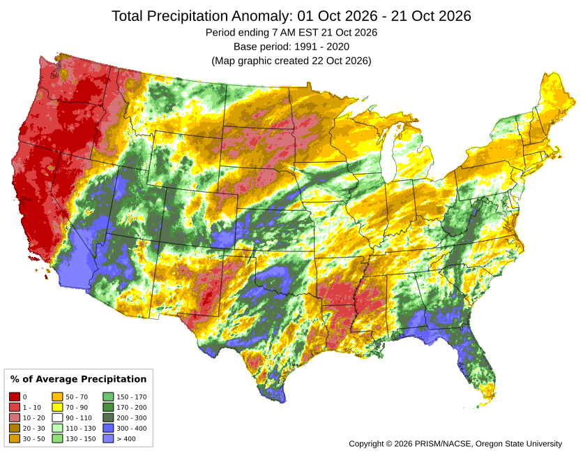
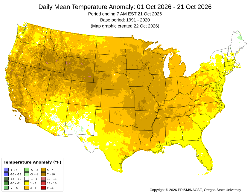
Pretty impressive reversal from the norm with the historic east based El Niño focusing the heaviest rains relative to the means around San Diego this month. So San Diego is getting the least San Diego-like weather during October. The CONUS has been getting an unusually warm October pattern for such a strong El Niño.
-

2026-2027 Record-breaking El Nino
GaWx replied to Stormchaserchuck1's topic in Weather Forecasting and Discussion
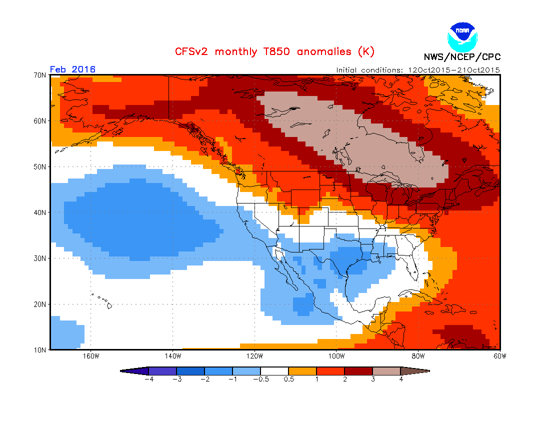
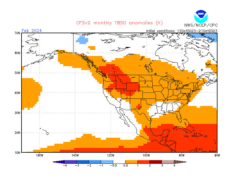
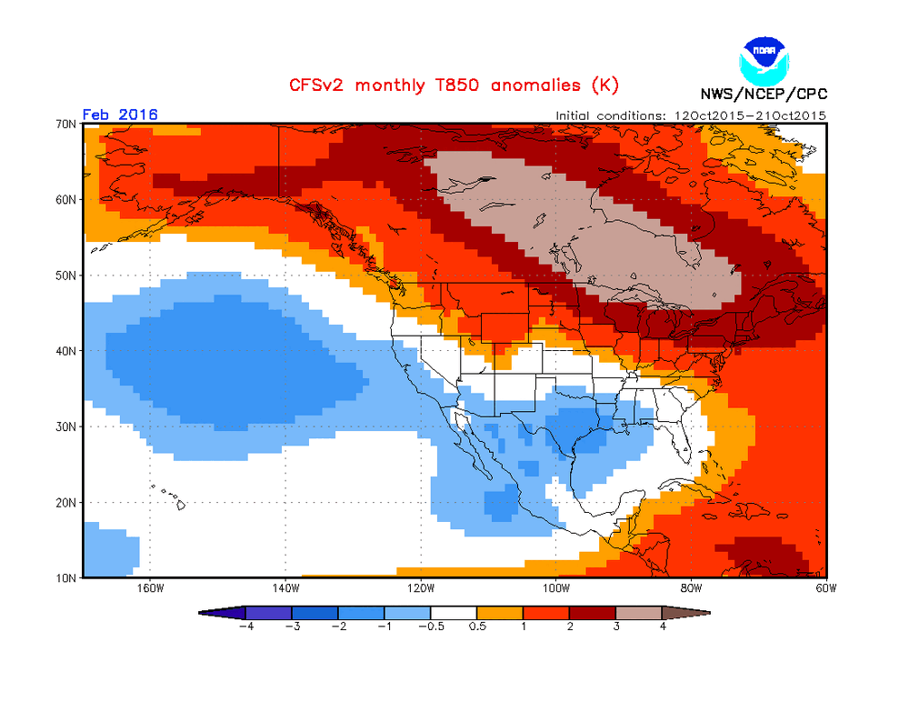
Latest CFSv2 10 day mean 850 mb fcast anomalies for Feb of 2027: note that >75% of Conus BN, including 30% 2-4 C BN, along with the extreme warmth in E Canada that is consistent with strong blocking there allowing the diverting of dominant Arctic cold into much of Conus: —————— In stark contrast, mid-Oct forecast for Feb ‘24: 85% AN in Conus/no block in E Canada in that much weaker/much less E based Nino vs 26-7: ————— In sharp contrast to mid-Oct forecast for Feb ‘16: only 15% BN, none sub -2C, and less extreme Canadian warmth centered >1,000 miles W of the Feb ‘27 forecast in that much less E based Nino vs 26-7: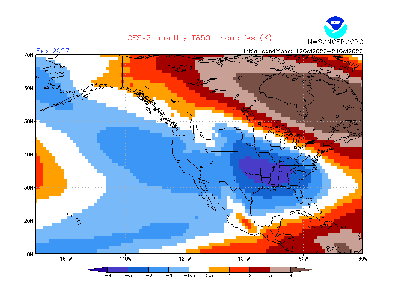
-

2026-2027 Record-breaking El Nino
Typhoon Tip replied to Stormchaserchuck1's topic in Weather Forecasting and Discussion
my opinion is that the +IOD and the +ENSO are all a part of the same super structure, exposed by observing the totality of the Walker construct. - whether aware or not... when evaluating either we are just in a quadrature (tranche) of that whole structure. The DVM tendencies over the eastern limb ( ^ ) of the +IOD mode is actually the western limb of the DVM associated with the Pacific Walker circulation. and so forth... The reason I see that distinction as important is because ... particularly in this incredibly wholesale immense +ENSO planetary state, there's likely to be less ability for permutations in the IOD domain to really mean anything because that region is subsumed by the whole/thus indicative of that larger magnitude. I don't think it is adding or "boosting" in this case...? Given to the above totality, it's already integrated already added in/accounting for in other words. But it does offer an intriguing idea after the fact ... that integration may create secondary feedbacks (synergistic amplitudes in either positive or negative direction). -
West Virginia color was pretty good when I was out there in early October. Driving through Monetary area last weekend after my snow hike and the colors were in peak and looked pretty. Then again, areas further west and south of NOVA were spared from the drought, and so far colors around Charlottesville haven’t been great.
-
I was thinking the whole electric/spark, and water being a conductor thing…should do the job of damaging a life form somewhat..?
-
His ideas on this winter, and every winter are exactly the same…so save yourself the time, and skip it.
-
New England color is allegedly one of the best years in a long time. Hoping we get a good one too.
-
Yes, I’d have to think they could be overcome, especially if they are self learning.
-
Min 34.0° More frost…still 36° Gonna need to find a way to frost protect a nonlignified tree this weekend. The tip already got frost burned from 26° despite a trash barrel over it. MOS is hitting 23° at CON Sat and Sun AM.
-
I love it. San Diego weather here for mid autumn.
-
I'm seeing that they are outperforming globals in mid range..but can't really be trusted for nuance in the short range (0-3 days) due to smoothing/blurring effect. I wonder if those short term problems are something that can be overcome with time.
-
October 22 1938: Sleet and wind cause damage along the Minnesota/Wisconsin border. 1913: Long Prairie receives a record low of 8 degrees F. For Thursday, October 22, 2026 1965 - The temperature soared to 104 degrees at San Diego, CA. Southern California was in the midst of a late October heat wave that year. Los Angeles had ten consecutive days with afternoon highs reaching 100 degrees. (David Ludlum) (The Weather Channel) 1985 - A guest on the top floor of a hotel in Seattle, WA, was seriously injured while talking on the phone when lightning struck. Several persons are killed each year when the electrical charge from a lightning bolt travels via telephone wiring. (The Weather Channel) 1987 - Yakutat, AK, surpassed their previous all-time yearly precipitation total of 190 inches. Monthly records were set in June with 17 inches, in September with 70 inches, and in October with more than 40 inches. (Sandra and TI Richard Sanders - 1987) Twenty-two cities in the eastern U.S., most of them in the southeast states, reported record low temperatures for the date. Morning lows of 30 degrees at Athens GA, 28 degrees at Birmingham AL, and 23 degrees at Pinson AL, were the coldest of record for so early in the season. (The National Weather Summary) Showers produced heavy rain in southern California, with amounts ranging up to five inches at Blue Jay. Flash flooding resulted in two deaths, ten injuries, and more than a million dollars damage. (The National Weather Summary) (Storm Data) 1988 - A "nor'easter" swept across the coast of New England. Winds gusted to 75 mph, and large waves and high tides caused extensive shoreline flooding. A heavy wet snow blanketed much of eastern New York State, with a foot of snow reported in Lewis County. (The National Weather Summary) (Storm Data) 1989 - A storm system moving out of the Gulf of Alaska brought rain to the Northern and Central Pacific Coast Region, with snow in some of the mountains of Oregon, and wind gusts to 60 mph along the Oregon coast. Six cities in Florida reported record low temp-eratures for the date, including Tallahassee with a reading of 34 degrees. (The National Weather Summary) (Storm Data) Observances: 22 Thu National Nut Day 22 Thu International Stuttering Awareness Day 22 Thu International Caps Lock Day 22 Thu National Color Day 22 Thu National Kristopher NaJee Roebuck Day 22 Thu National Make a Dog’s Day 22 Thu Scar Appreciation Day 22 Thu Smart is Cool Day
-
The bigger point is that you were below 32…like most all of New England has been already this fall.
-
You might be able to close your eyes, and have better success in drawing up a better and more accurate depiction. Throw that thing in the trash.
-
Low of 33 in Pen-Mar. Coldest morning this season but growing season lives on. Challenged Fri/Sat night.
-
They’re actually doing darn good….
-
Right? What a beautiful fall that has unfolded. These sunny mild days and cool nights are going to bring on some high quality fall color. I'm pretty excited for upcoming peak color.
-
RDU also got in 30's for first time this season. 39.9
-
2026-2027 Record-breaking El Nino
GaWx replied to Stormchaserchuck1's topic in Weather Forecasting and Discussion
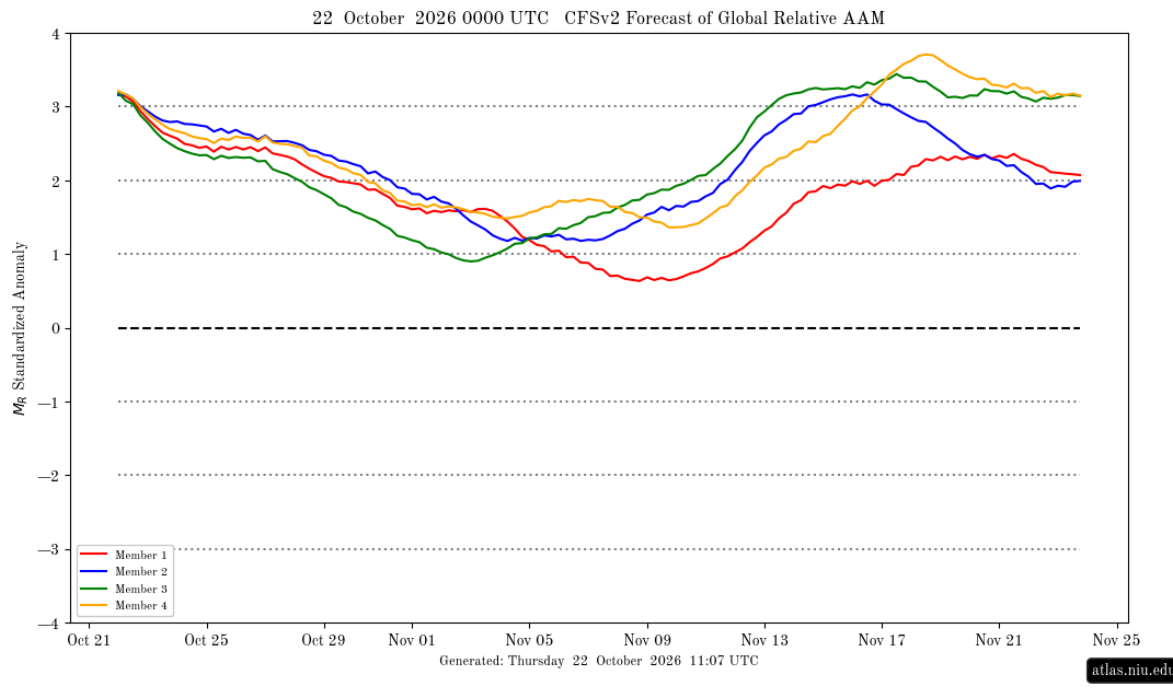
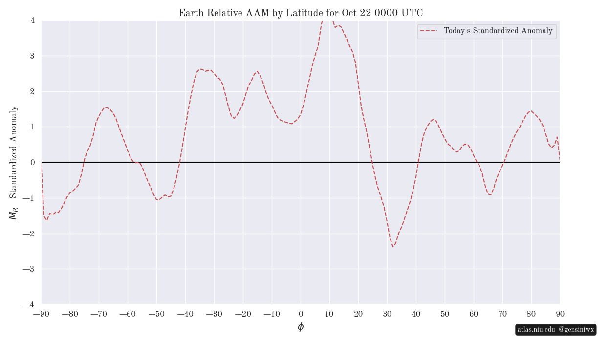
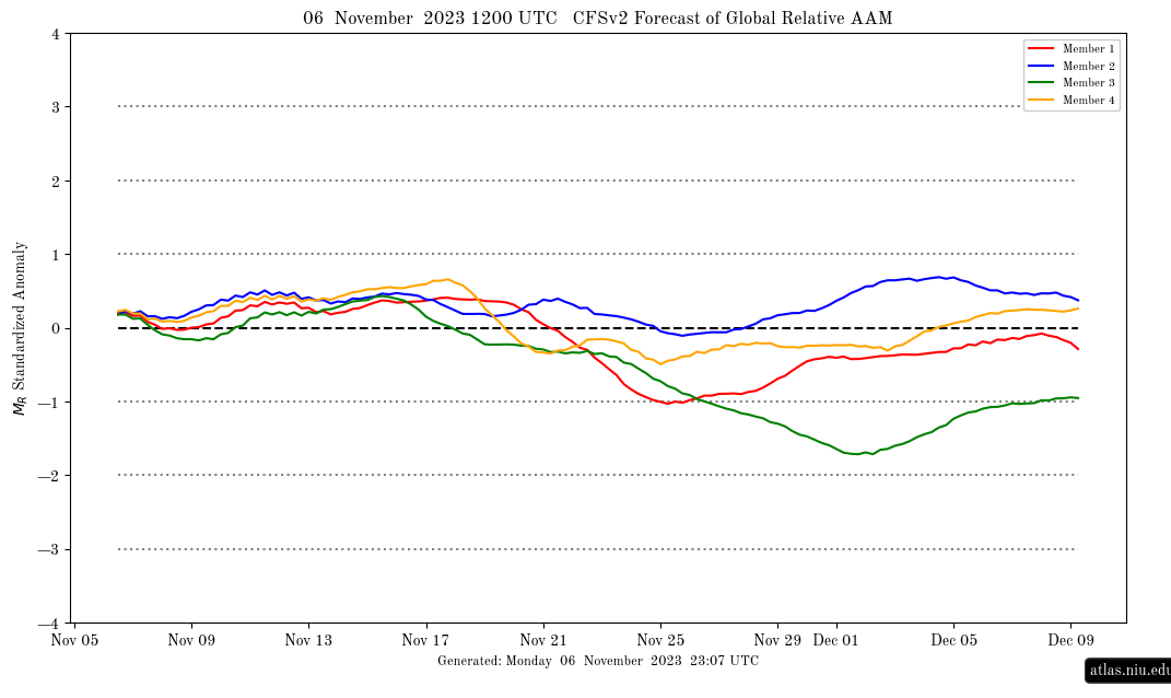
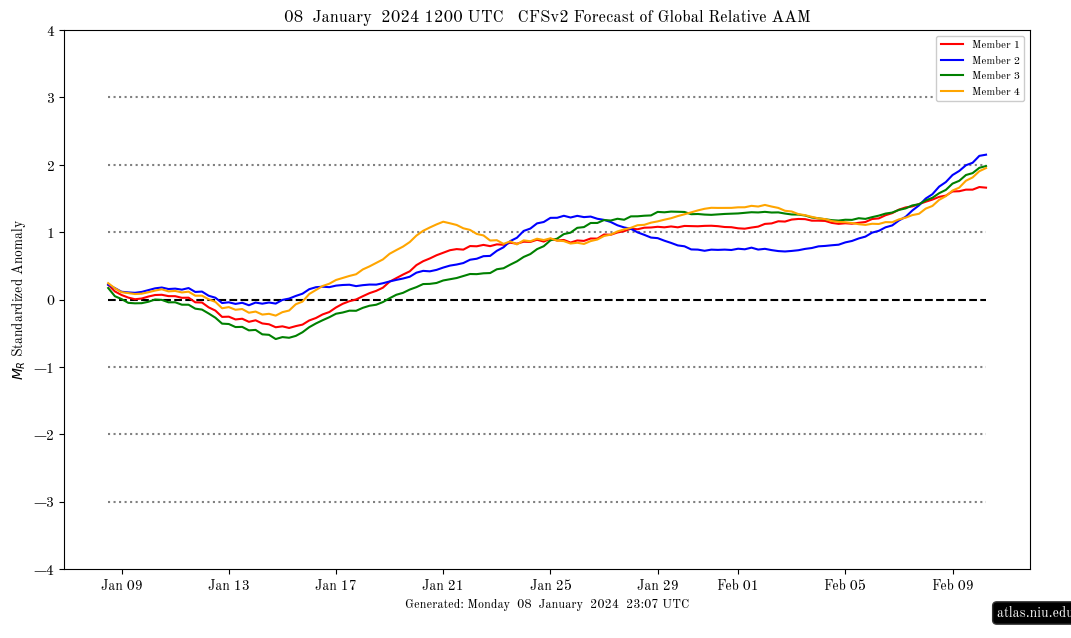
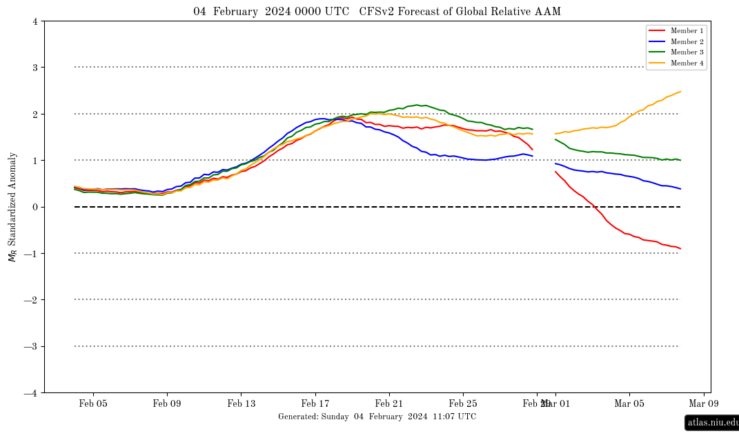
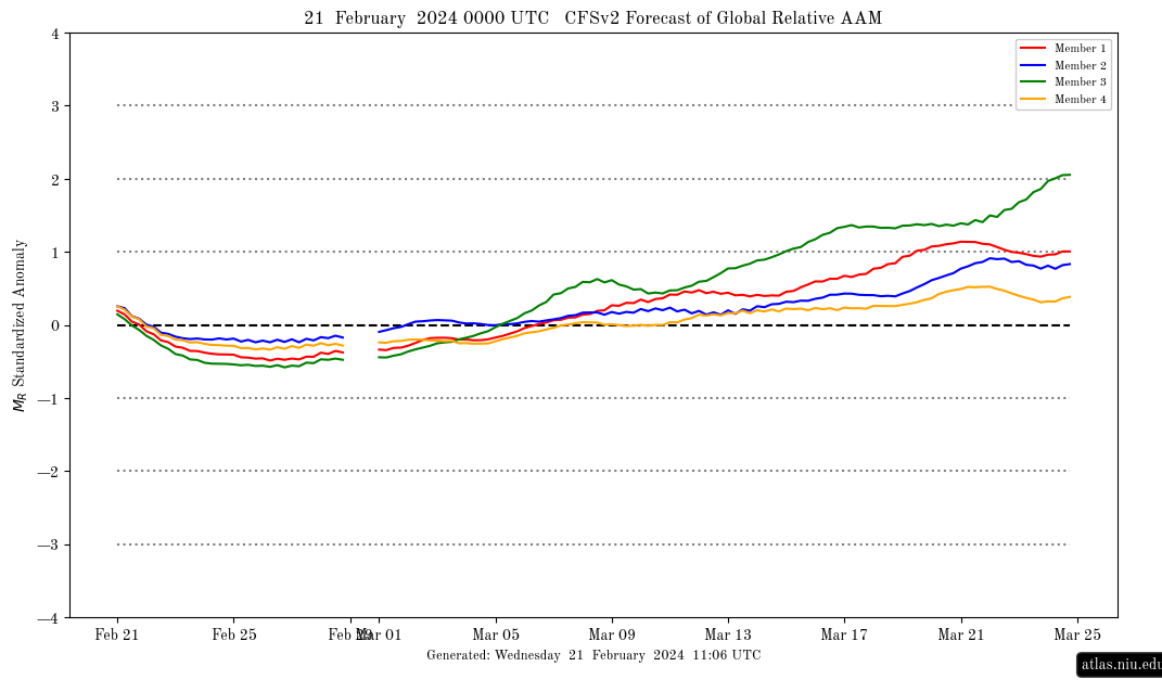
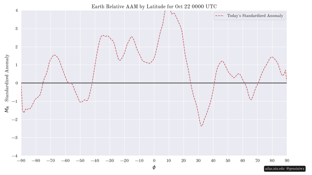
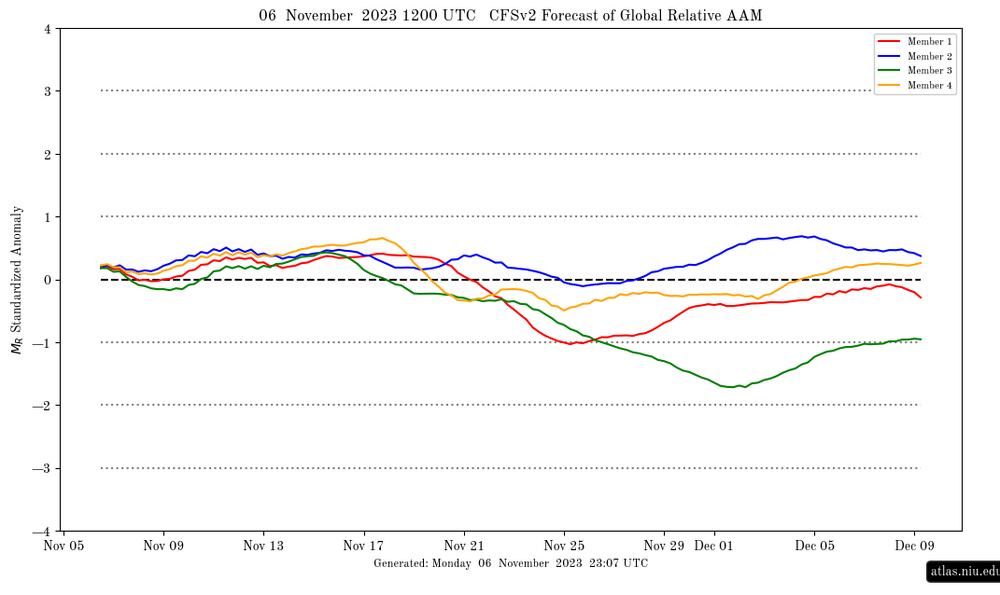
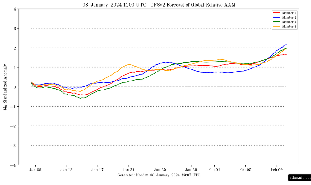
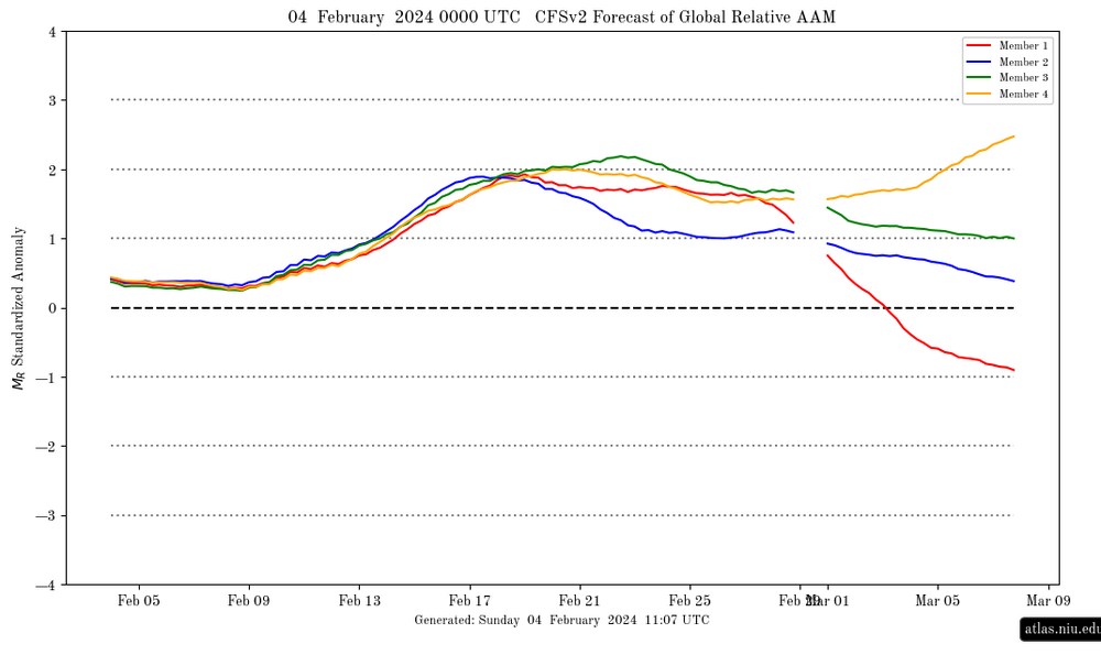
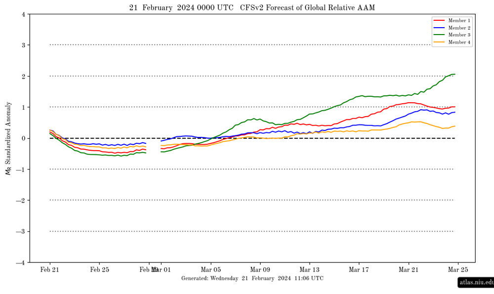
Today’s CFSv2 GLAAM forecast (see top image below): currently extremely high at +3 SD; though very high, Oct is not as high as record-breaking Sep (keep in mind that it amazingly exceeded +4 SD for a 6 day period (within 9/17-23), which may not happen again for decades): By latitude: similar pattern that has dominated for awhile with the strongest positive anomalies S of 20N: In contrast, 2023-4 was nothing of the sort: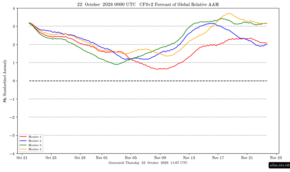
-
I don’t have anything against him personally but I do think Forky needs a break. I don’t entirely disagree with his views on this upcoming winter, but his thinking has gotten way too inflexible. Cognitive rigidity impedes creativity and it narrows your world.
- Today
-
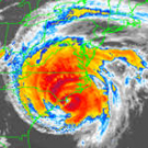
Isn't there a recurving typhoon in the Pacific? Waiting for a @jaxjagmandownstream update and perhaps another to give their take on the Euro Weeklies showcasing a different look second half of November. At least the mornings/evenings feel glorious as we wait for the pattern to flip. It's already Thanksgiving for the Four Corners.
-

2026-2027 Record-breaking El Nino
michsnowfreak replied to Stormchaserchuck1's topic in Weather Forecasting and Discussion
Ohhh there will be lots of forecasts, and "forecasts", that will be fun to score. (And i too think the quoted forecast is too cold).