All Activity
- Past hour
-
1" of rain and EF1 TOR's
-

September 2025 OBS-Discussion centered NYC subforum
SACRUS replied to wdrag's topic in New York City Metro
76 / 74 here 0.22 in the bucket so far. -
Not sure about rain totals near TAN, but was in Dighton/North Taunton earlier and it was torrential rains. I'd guess at least 1" in 20 minutes
-
Almost at 1.00” with this incoming.

-

September 2025 OBS-Discussion centered NYC subforum
WeatherGeek2025 replied to wdrag's topic in New York City Metro
how's it looking for Sunday? any rain or suppression ? -
Starting at 1:00 pm Sunday???(trying to will something into existence on timing) Ah well, you all can thank me for making this reservation on Monday if we end up with a region wide drought buster...
-
Gfs jumping towards euro solution for this weekend
-
Doing a quick mid-afternoon arrival to overnight in Rehobeth Saturday - hoping the Euro is a hair off on timing - maybe delay onset of whatever that is gonna be until midday Sunday...
-
-
This final line is looking very meager Sent from my SM-G970U1 using Tapatalk
-

September 2025 OBS-Discussion centered NYC subforum
Brian5671 replied to wdrag's topic in New York City Metro
heavy downpour here -
TDS northeast of Rockland
-
 Some of the second tier models still have a binary interaction that pulls future Imelda away, but with the Euro/GFS/AI models aligning at least right now that increases the risk to the coast substantially imo. Still, any one solution is far from guaranteed.
 -

September 2025 OBS-Discussion centered NYC subforum
winterwx21 replied to wdrag's topic in New York City Metro
Only 0.17" here between last night and today so far. It's going to be a major disappointment if we don't get a downpour this afternoon or tonight. -
Looks like 75-80 today. Very warm, pleasant late Sept day. I'll take it after the cooler, cloudy, wet wx.
-
Seems unlikely we score 1" Sent from my SM-S921U using Tapatalk
-
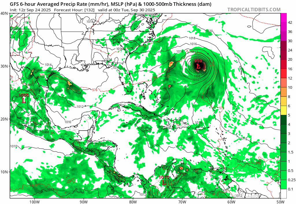
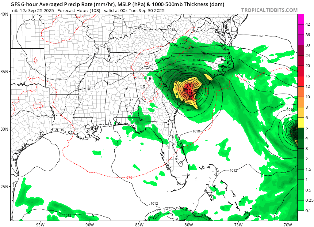
Crazy part is that's Monday! Went from no storm at all at 12z yesterday to a Cat 1-2 landfall coming in 3.5 -4 days. I don't envy forecasters. What a very complex and tricky set up with the different interactions. I know the forecast discussions have been harping it but for the general population, could be quite a shock to wake up to hurricane watches potentially Saturday morning.
-
that's because just 3 days ago they were showing 3-6"
-

September 2025 OBS-Discussion centered NYC subforum
Picard replied to wdrag's topic in New York City Metro
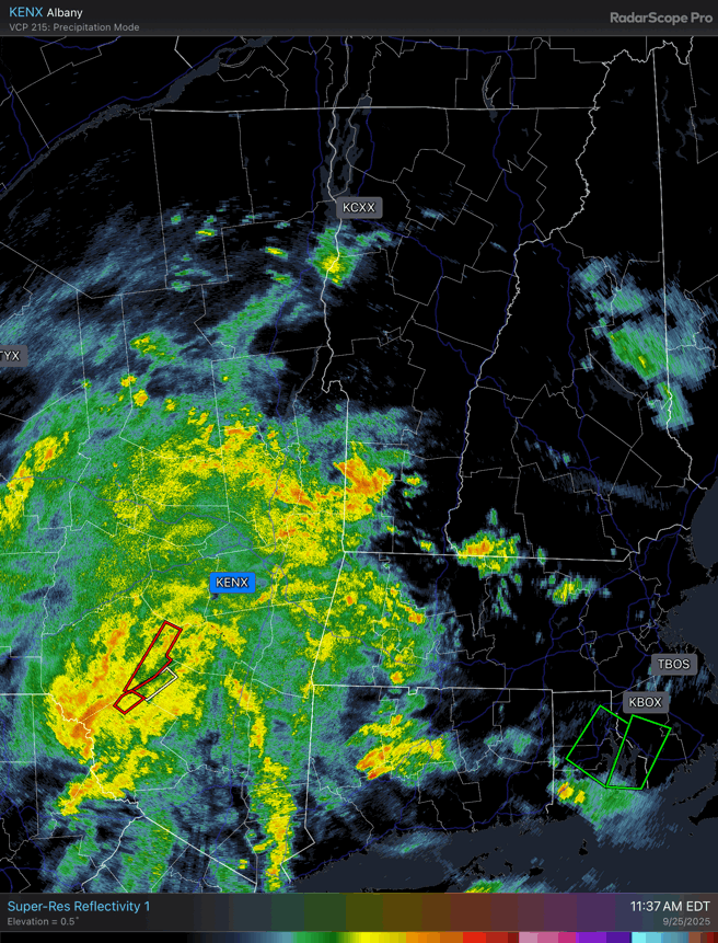
Light rain. Dewpoints are atrotious, and the AC in my classroom doesn't work, so that's fun. If I'm reading it right, Scranton PA has picked up 2.3 inches of rain so far today, and seems to be in the bullseye of heaviest rain. -
Yup building ridge to the north just traps it. Of course, that’s the furthest out and least confident part of the forecast.
-

September 2025 OBS-Discussion centered NYC subforum
Intensewind002 replied to wdrag's topic in New York City Metro
Only 0.3" here since Tuesday morning, dew point up to 73 here makes it feel like mid July -
Pretty cool trends...unfortunately gets stuck in SC

-

Invest 94L—70% 2 day and 90% seven day odds of development
MJO812 replied to WxWatcher007's topic in Tropical Headquarters
SC landfall on gfs
-
-

September 2025 OBS-Discussion centered NYC subforum
bluewave replied to wdrag's topic in New York City Metro
Yeah, it was just something that you got used to living in Long Beach being right under the approach to JFK. The planes ultimately will have to flyover someone’s neighborhood with how busy JFK and LGA are. I hope they can change things up a bit to make the noise a little lower in your area.


(002).thumb.png.6e3d9d46bca5fe41aab7a74871dd8af8.png)