All Activity
- Past hour
-

Strong Nor'Easter/Hybrid Storm Late September 2026
MJO812 replied to Rjay's topic in New York City Metro
The tide is already high. I drove past the Belt Parkway this morning and the waves were crashing against the rocks and onto the walkway. -

Strong Nor'Easter/Hybrid Storm Late September 2026
NEG NAO replied to Rjay's topic in New York City Metro
-

Strong Nor'Easter/Hybrid Storm Late September 2026
jbenedet replied to Rjay's topic in New York City Metro
I remember distinctly with Sandy it was a dry storm on LI and drought conditions leading into it. That really helped mitigate the wind and power outage impacts. This is obviously a much weaker storm but the convective nature of it should help to maximize the rainfall (fresh water flooding) and wind threat along the coast. -
nice of joe's football team to come through for us haters
-
It's here!!! 48 in Cherryville this morning and there was much rejoicing!
-

October Comes Early: Late September Multi-Hazard Hybrid Storm
weatherwiz replied to WxWatcher007's topic in New England
I'd also watch for models overall to perhaps miss some of the very early rain potential (which could have implications on overall flooding risk too). Wouldn't be shocked to see some rain and rain bands get in much earlier than indicated and the rainfall rates would be quite heavy. Maybe progressive movement limits totals but something to watch -
Yeah man...that was awful last night . Falcons did that to us last year but we didn't have a 55 million dollar QB. TB worries me...remember Baker said he knew the calls last time. Anyway...it's better to be 2-0 than not
-

October Comes Early: Late September Multi-Hazard Hybrid Storm
kdxken replied to WxWatcher007's topic in New England
Congratulations woodyard too. -
I figured it’d be below 0 there.
-

October Comes Early: Late September Multi-Hazard Hybrid Storm
Chrisrotary12 replied to WxWatcher007's topic in New England
Really liked the overnight runs. Looks like might be able to sneak it in. Plus need to get in a crappy weather round ahead of the Mid-Am at Mt. Washington 1st week of October. -
Now to be replaced by the Packers sucking. ‘Tis a beautiful thing.
-

Strong Nor'Easter/Hybrid Storm Late September 2026
jconsor replied to Rjay's topic in New York City Metro
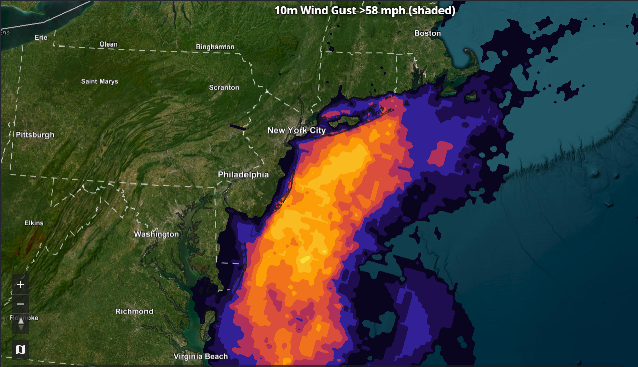
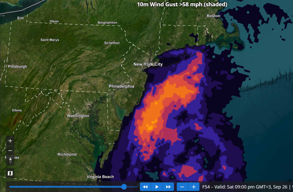
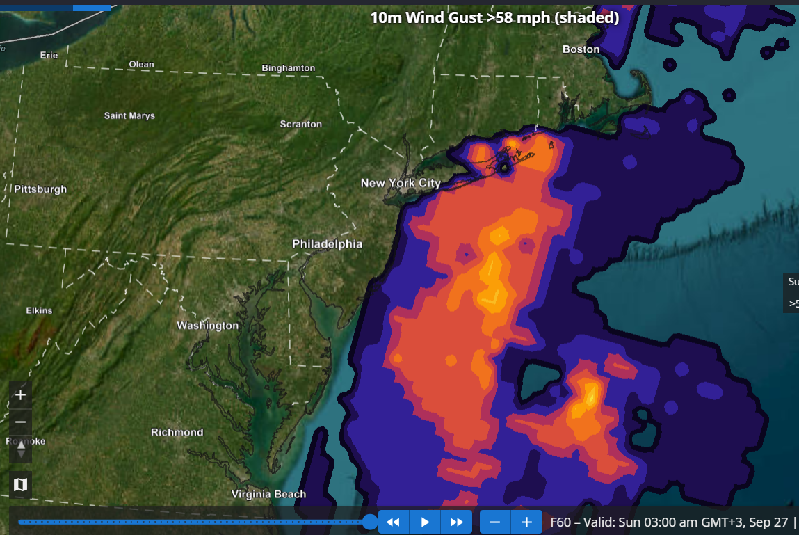
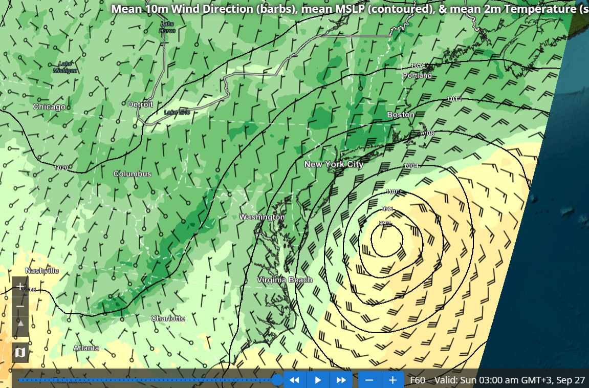
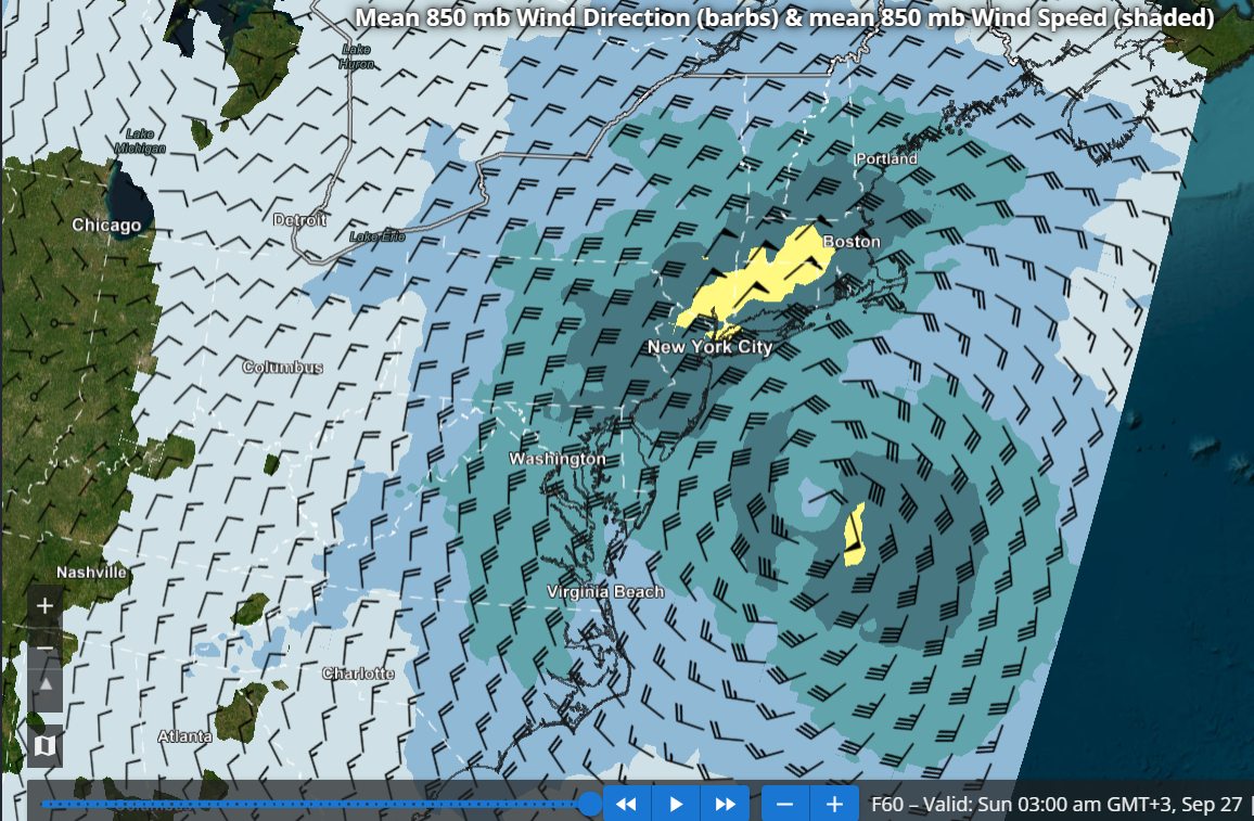
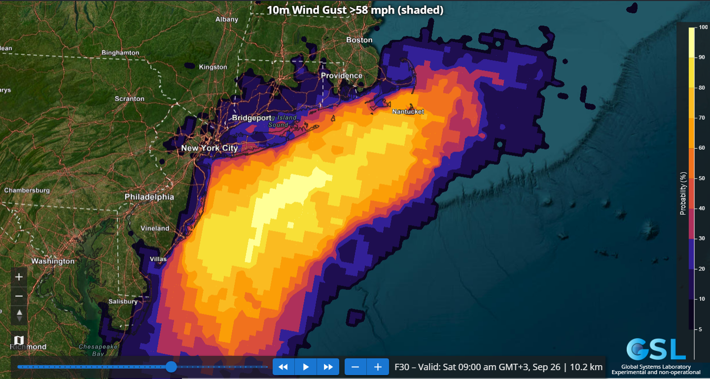
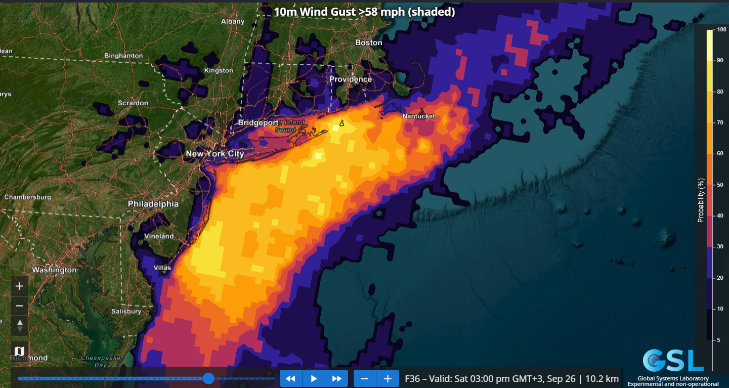
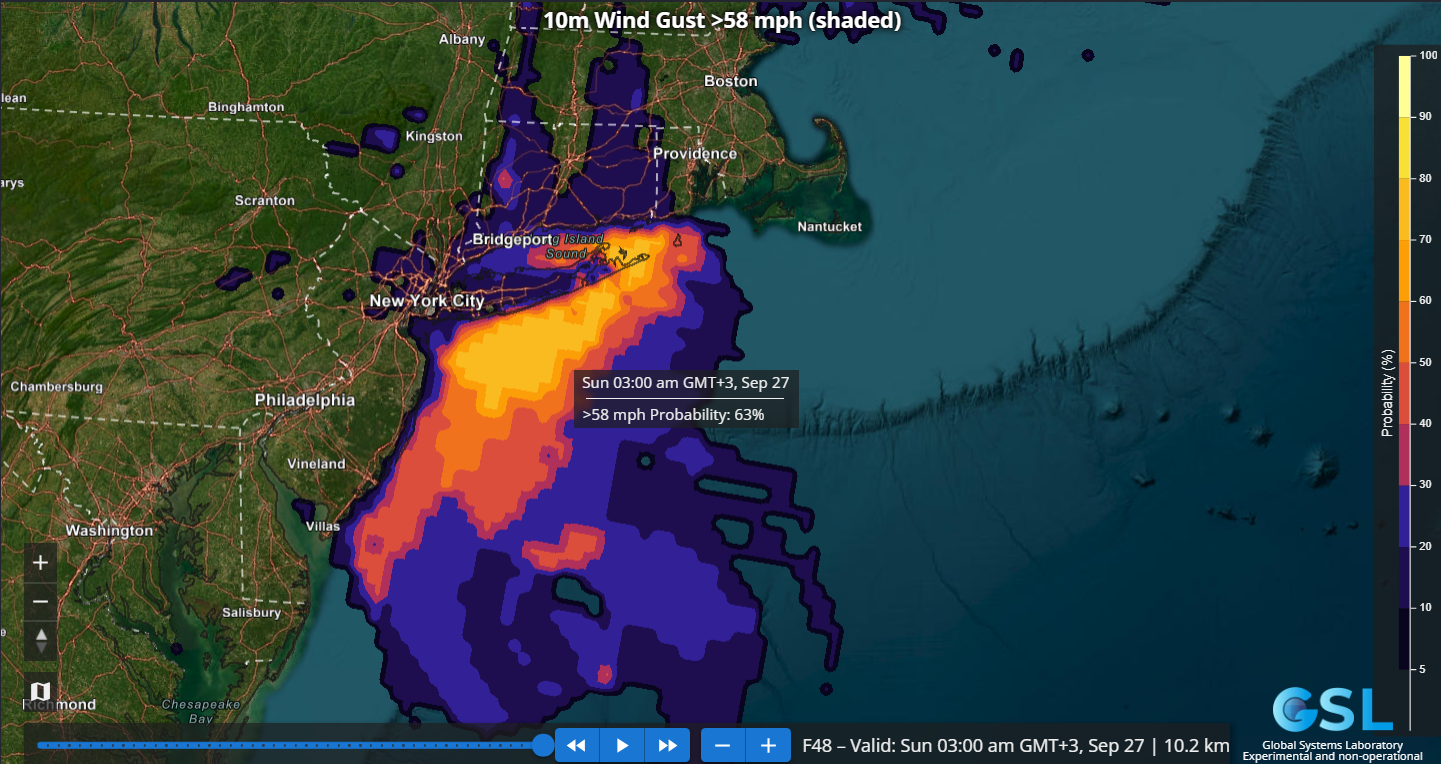
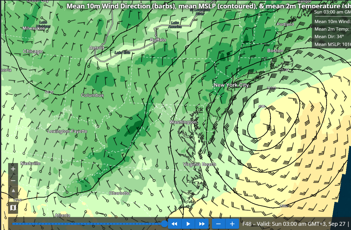
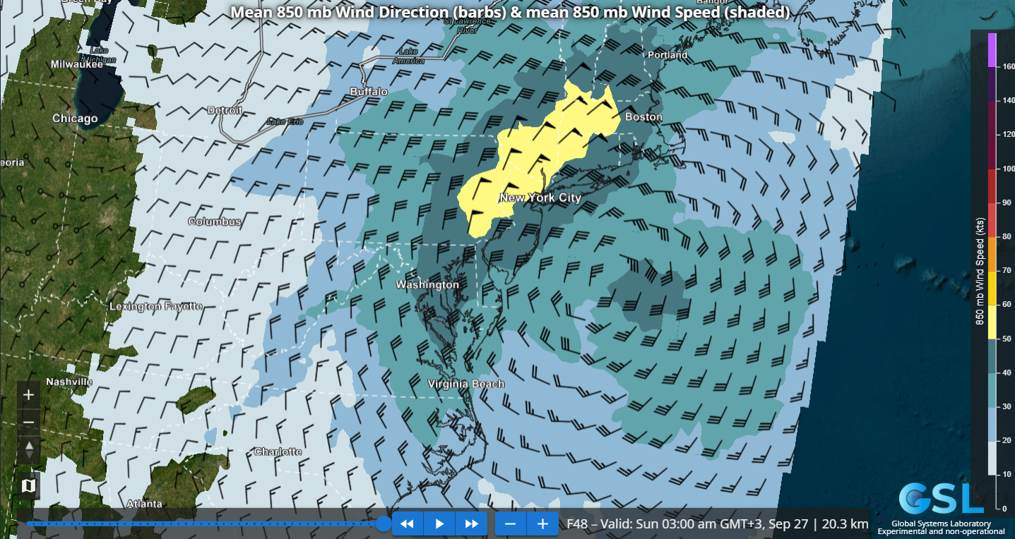
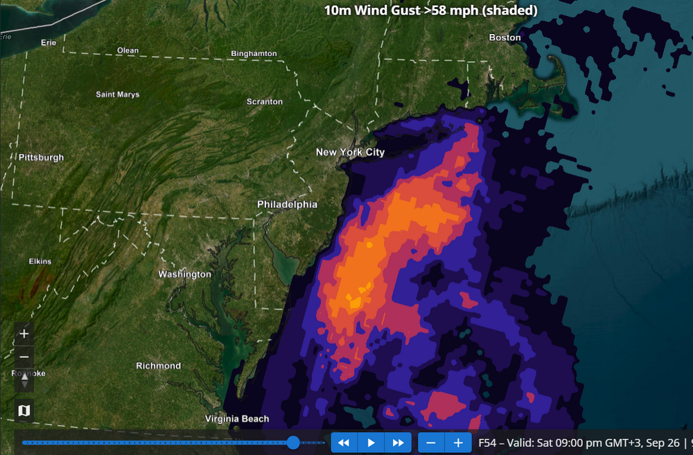
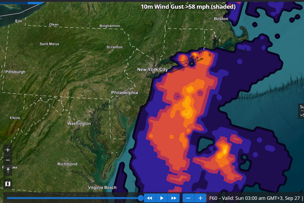
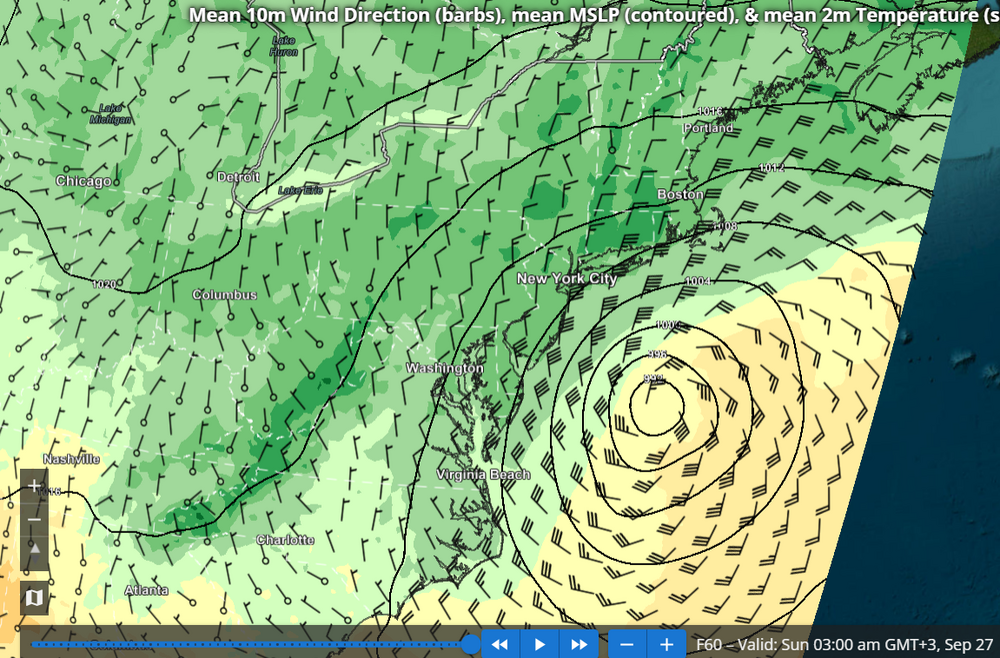
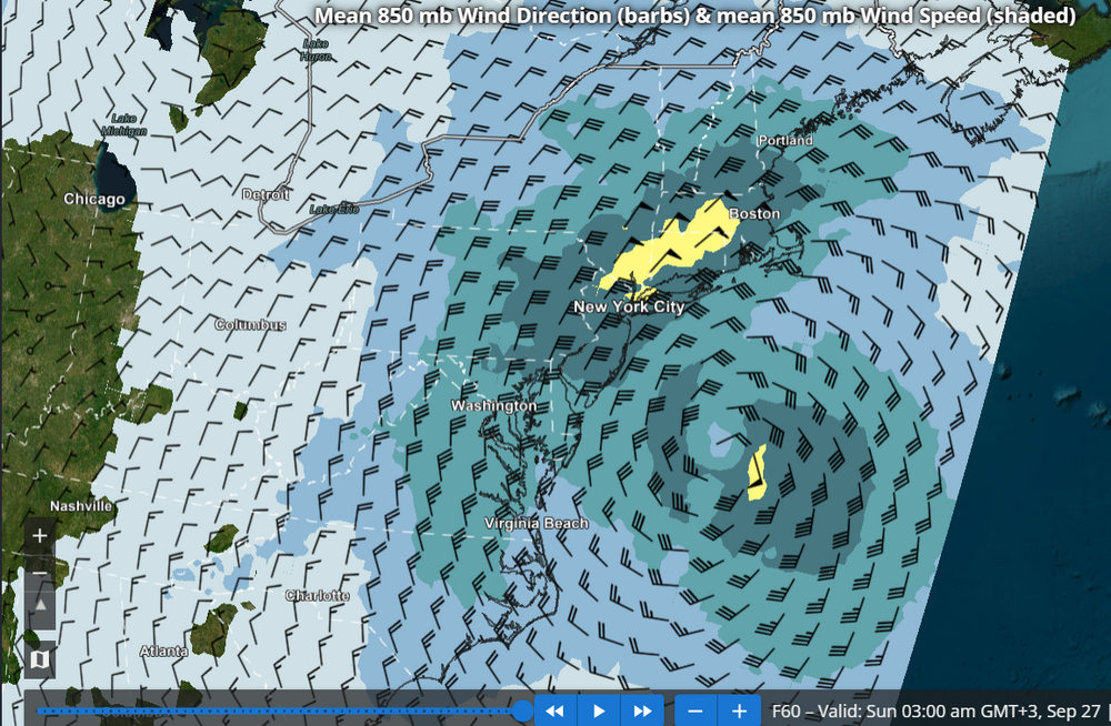
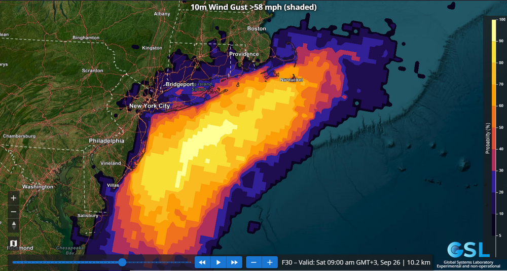
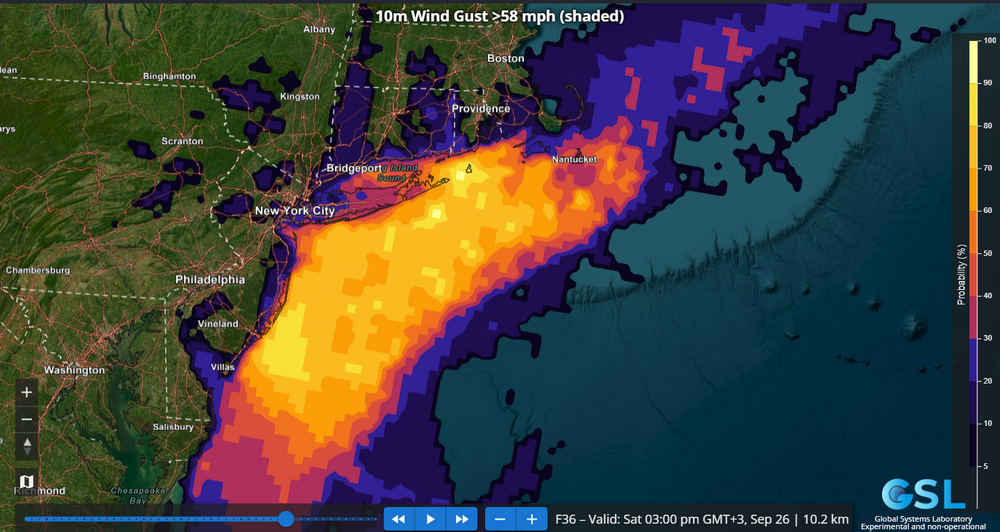
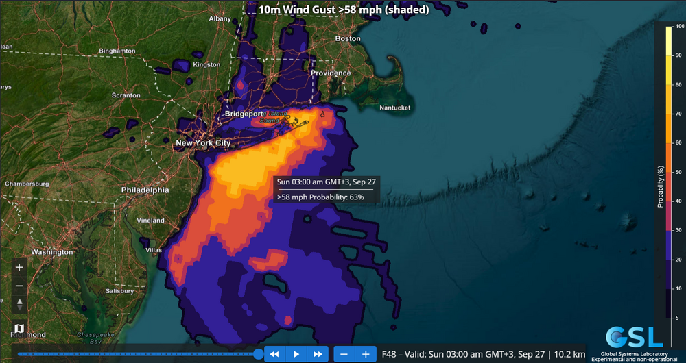
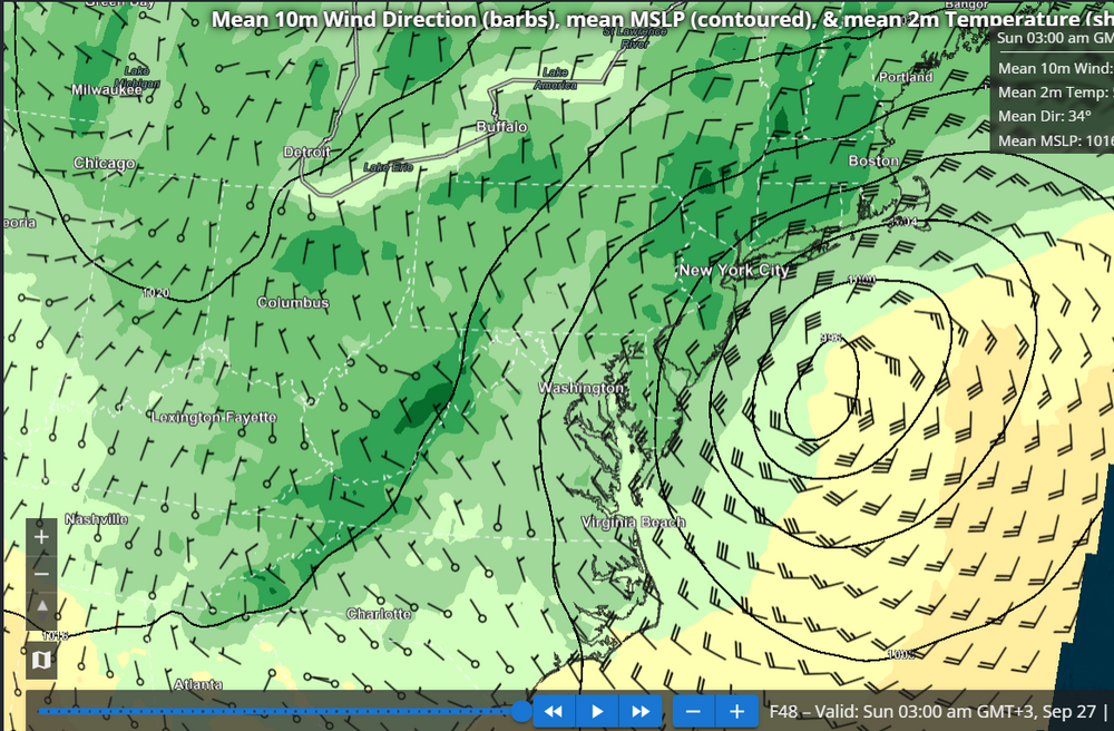
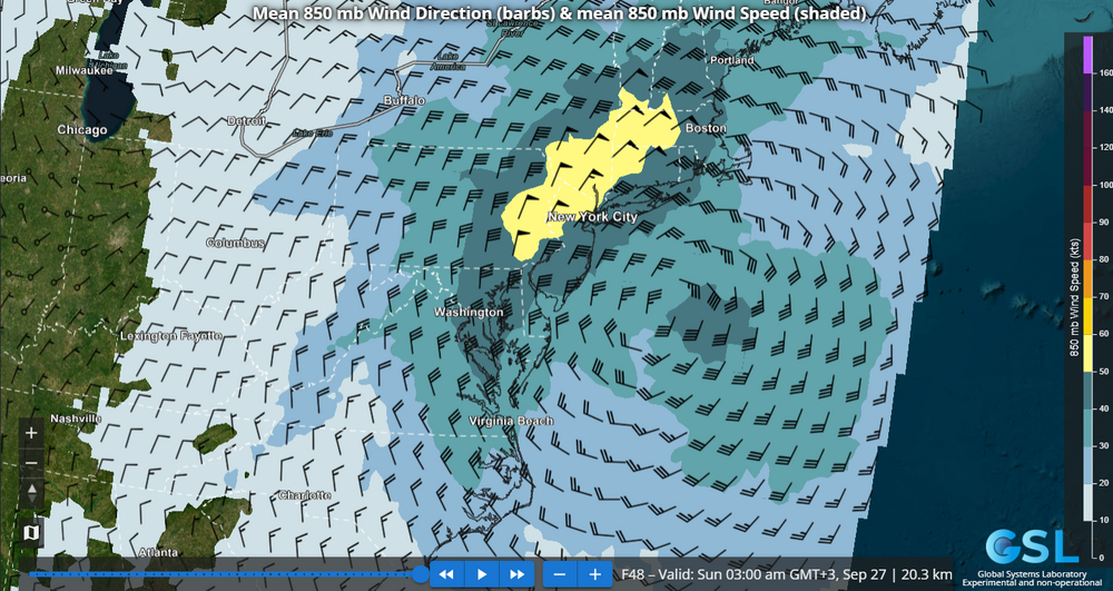
The REFS (RRFS ensemble) probability of wind gusts exceeding High Wind Warning criteria e.g. 58 mph for Sat into early Sun morning remains unnervingly high for the South Shore of LI as well as Eastern Suffolk. Additionally, on this run, the probabilities over 25% have edged into southern portions of NYC like southern SI and far southern Brooklyn and Queens. Still unclear to me why NWS Upton is holding back on a high wind warning for the above-mentioned areas, especially eastern Suffolk where the model consensus is strongest. Note the REFS has shifted NW with the position of the low pressure and the 850 mb low center at 48 hours, if you compare to the 60 hour forecast from the previous post.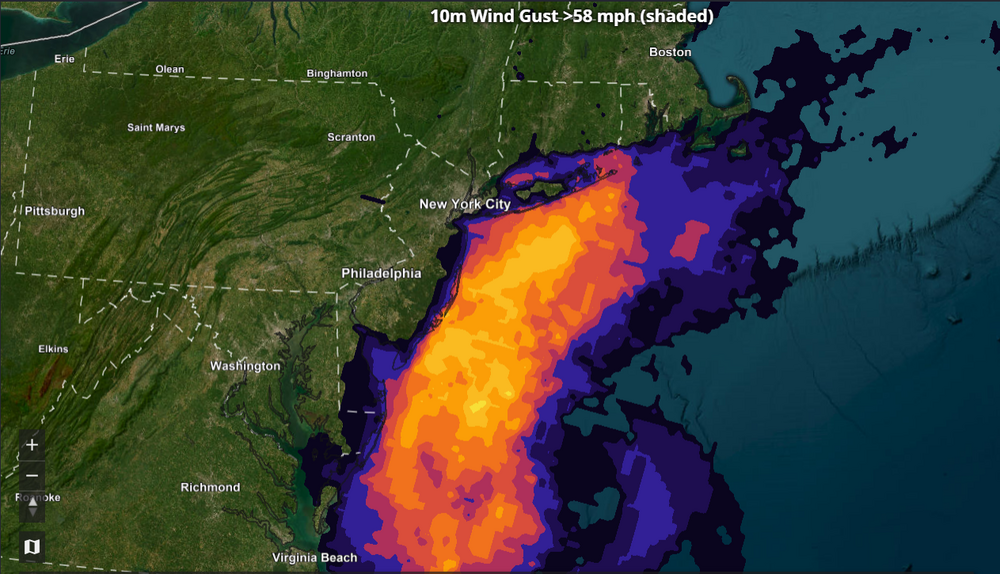
-
Thanks! What’s the link for that?
-
October Comes Early: Late September Multi-Hazard Hybrid Storm
Chrisrotary12 replied to WxWatcher007's topic in New England
The 24 at ASH compared to 30s everywhere else is chef's kiss. These models are getting good. -

October Comes Early: Late September Multi-Hazard Hybrid Storm
Ginx snewx replied to WxWatcher007's topic in New England
Congrats SCOOTER and Masswx.png.2fb76ea236c3c97481f239902fad328d.png)
-

Strong Nor'Easter/Hybrid Storm Late September 2026
TriPol replied to Rjay's topic in New York City Metro
NWS blinked... a little. We now have Coastal Flood Warnings along the entire coast of Long Island. Really wish they would issue Flood Watches and High Wind Warnings as well. National Weather Service New York NY 644 AM EDT Fri Sep 25 2026 .WHAT HAS CHANGED... Coastal Flood Warnings have been issued for a large portion of the coastline to cover multiple high tide cycles from tonight through Sunday. The Wind Advisory was expanded in area. It now includes all of Long Island, NYC, all of S CT, all of Westchester, Rockland, and all but W Passaic in NE NJ. All ocean waters are now under a Storm Warning. -
40 when I woke up 47 now
-
 It’s had that signal overnight Saturday into early Sunday for some very strong winds on and off . Almost like a 2nd pulse
 -

Septorcher 2026 Discussion - Endless Summer
BrianW replied to Damage In Tolland's topic in New England
I have been using mini splits for the last 8 years in my all electric/solar house. I monitor the electricity consumption of everything and its incredible how efficent mini splits are. I kicked mine on a few mornings this week and they used like 1-2 kwh running a few hours in the morning. Thats like 50-60 cents in electricity. I could see if I had $6 heating oil waiting but your only saving like less than a dollar to be cold. -
Coastal deluge on the ne coast otherwise most rain is west and / nations middle
-

October Comes Early: Late September Multi-Hazard Hybrid Storm
dendrite replied to WxWatcher007's topic in New England
6z euro has a period there Sat night where 925 gets up to 65-70kt over CT. It’s tough to see on the soundings but it looks like 55kt at 950 over you 6z Sun and the 950-sfc layer is moist adiabatic. -
Records: Highs: EWR: 91 (1970) NYC: 90 (1970) LGA: 90 (2010) JFK: 87 (2010) Lows: EWR: 39 (1950) NYC: 40 (1887) LGA: 42 (1950) JFK: 45 (1989) Historical: 1848 - The Great Gale of 1848 was the most severe hurricane to affect Tampa Bay, Florida and is one of two major hurricanes to make landfall in the area. This storm produced the highest storm tide ever experienced in Tampa Bay when the water rose 15 feet in six to eight hours. 1848: The Tampa, FL area was hit by a major hurricane. The pressure plunged to 28.18 inches of mercury and the storm surge reached 15 feet. The army post in the area was wiped out. (Ref. Wilson Wx. History) 1926: The coldest temperature ever recorded in Scottsbluff, NE for the month of September occurred on this with a low of 14°, while Chadron, NE recorded their lowest September temperature with 15°. Western Yellowstone, MT recorded -9 °F which was then the lowest temperature reading in the 48 states for September. (Ref. AccWeather Weather History) 1929: Willmar, MN experiences a deluge that dropped 5.22 inches of rain in 24 hours. (Ref. AccWeather Weather History) 1939 - A west coast hurricane moved onshore south of Los Angeles bringing unprecedented rains along the southern coast of California. Nearly five and a half inches of rain drenched Los Angeles during a 24 hour period. The hurricane caused two million dollars damage, mostly to structures along the coast and to crops, and claimed 45 lives at sea. ""El Cordonazo"" produced 5.66 inches of rain at Los Angeles and 11.6 inches of rain at Mount Wilson, both records for the month of September. (David Ludlum) (The Weather Channel) 1942: The earliest first trace of snow in Chicago occurred on this date in 1942 and 1928. First snow of the season Average; October 30 Earliest; September 25 (1928 and 1942) Latest; December 5, 1999 First measurable snow (.1 inches or more) of the season Average; November 16 Earliest; October 12, 2006 Latest; December 16, 1965 Snow Trivia for Chicago - NWS 1953: The center of Hurricane Florence hit the northwest Florida coast between Valparaiso and Panama City near midday with wind maximum sustained winds near 80 mph with gusts to 90 mph and heavy rainfall. The Pensacola Weather Bureau Office reported winds of up to 75 mph early the next morning. The storm passed inland over a sparsely settled area of Florida and this probably accounts for the rather small amount of damage. In Franklin and Okaloosa Counties the Red Cross estimated that 273 homes were destroyed, 145 other buildings damaged, and three destroyed. A fishing trawler, the "Miss Tampa" was reported missing in the storm's wake. (Ref. Wilson Wx. History) 1962: The remnants of Tropical Storm Claudia of 1962 dumped up to 7 inches of rain in the desert west of Tucson, AZ, causing severe flooding. By the year 2010 there had already been six storms by the name of Claudia. (Ref. Wilson Wx. History) 1975: On September 25 and 26 Elloise gave Hayfield secondary School 5.58 inches rain that closed Fairfax County schools September 26th 1975. The remnants of Hurricane Eloise combined with a cold front and produced very heavy rainfall in the Mid-Atlantic. Washington, DC reported 9.08" of rainfall. Total damage for Virginia was estimated to be $17.2 million. (Ref. Washington Weather Records - KDCA) 1976: Up to 3 inches of rain fell on Tucson, Arizona. About a dozen cars, some occupied, were swept down the washes, resulting in one death. Two boys were carried down the Rillito River for a mile before they could reach ground after their car was swept away. Talk about lucky! (Ref. AccWeather Weather History) 1984: Sheridan, WY recorded their coldest September temperature on record when they fell to 6°. 21 inches of snow fell at Sheridan between the 23rd and the 27th. This made it their snowiest September on record. Other record lows included: Cheyenne, WY: 17°, Casper, WY: 20° and Rapid City, SD: 24°. (Ref. Wilson Wx. History) 1987 - Hurricane Emily crossed the island of Bermuda during the early morning. Emily, moving northeast at 45 mph, produced wind gusts to 115 mph at Kindley Field. The thirty-five million dollars damage inflicted by Emily made it the worst hurricane to strike Bermuda since 1948. Parts of Michigan and Wisconsin experienced their first freeze of the autumn. Snow and sleet were reported in the Sheffield and Sutton areas of northeastern Vermont at midday. (The National Weather Summary) (Storm Data) 1988 - Low pressure off the Northern Pacific Coast brought rain and gale force winds to the coast of Washington State. Fair weather prevailed across most of the rest of the nation. (The National Weather Summary) 1989 - Twenty-three cities in the south central U.S. reported record low temperatures for the date, including Topeka KS with a reading of 33 degrees, and Binghamton NY with a low of 25 degrees. Showers and thunderstorms in the southeastern U.S. drenched Atlanta GA with 4.87 inches of rain, their sixth highest total of record for any given day. (The National Weather Summary) (Storm Data) 1993: In both human and economic terms the Great Flood of 1993 was the most devastating in modern U.S. history. It was a catastrophe across portions of 9 states with losses estimated up to $20 billion dollars. Over 50,000 homes were damaged or destroyed forcing the evacuation of some 54,000 people. In all the floods took 50 lives. Water level records were set at 49 places on the Missouri River system and at 43 places on the upper Mississippi River system. The flood was notable for its duration as well as its size. Flooding began in March with record floods beginning in May and continued into September. (Ref. Wilson Wx. History) 1994: Hail to 1 inch diameter was pounding Hebron, NE. A man ventured out into the storm to release a dog tied to a tree. Lightning killed the man and injured a woman at the scene. The dog was unhurt. (Ref. Weather Guide Calendar with Phenomenal Weather Events 2011 Accord Pub. 2010, USA) 1996: An early season snowstorm brought the season’s first snow to the Front Range eastern foothills in northern Colorado. Heavy snowfall totals included: 8 to 12 inches near Conifer, 7 inches at Floyd Hill, 6 inches at Bailey & Chief Hosa and 4.7 inches at Denver. Heavy rain fell in the Blackwell area of north-central Oklahoma beginning the previous day through this date, causing many roads to be closed. National Weather Service radar estimated that more than three inches of rain fell in less than 90 minutes in central Kay County, late in the evening. The two day rainfall in Blackwell totaled 9 inches. (Ref. Wilson Wx. History) 1998: By the 5 PM ET advisory, 4 hurricanes were spinning simultaneously in the Atlantic basin: Georges, Ivan, Jeanne, and Karl. That was the first time this had happened since 1893. After moving along the north coast of Cuba the previous day, Georges crossed the Florida Keys, heading into the Gulf of Mexico. The storm had re-intensified with winds of 105 mph when it made landfall near Key West, FL midday. (Ref. AccWeather Weather History) 1998 - Four hurricanes were spinning simultaneously in the Atlantic basin: Georges, Ivan, Jeanne, and Karl. That was the first time this had happened since 1893. 2004: Jeanne after performing a complete loop over the open Atlantic, it headed westwards, strengthening into a Category 3 hurricane. Jeanne passed over the islands of Great Abaco and Grand Bahama in the Bahamas on September 25. Jeanne made landfall later in the day of the 25th in Florida just 2 miles (3 kilometers) from where Frances had struck 3 weeks earlier. Building on the rainfall of Frances and Ivan, Jeanne brought near-record flood levels as far north as West Virginia and New Jersey before its remnants turned east into the open Atlantic. Jeanne is blamed for at least 3,006 deaths in Haiti with about 2,800 in Gonaïves alone, which was nearly washed away by floods and mudslides. The storm also caused 7 deaths in Puerto Rico, 18 in the Dominican Republic and at least 4 in Florida, bringing the total number of deaths to at least 3,025. Final property damage in the United States was $6.8 billion, making this the 13th costliest hurricane in U.S. history. Hurricane Jeanne's Track - Weather Underground (Ref. More on Hurricane Jeanne)
-
31.6 there at 7:15 this morning
-
They oopsied on the forecasted low here, was 42. I glanced around the local area, and I am actually one of the warmer numbers, range is from 34 to my 39. Pretty sure someone got frost that wasn't called for.
-
Strong Nor'Easter/Hybrid Storm Late September 2026
jconsor replied to Rjay's topic in New York City Metro
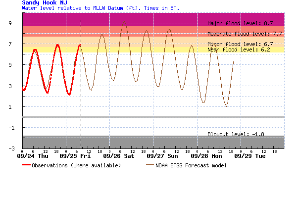
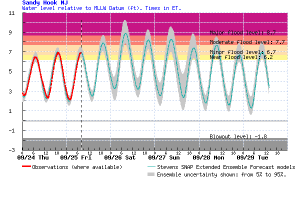
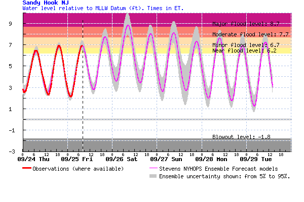
The NWS water level forecast for Sandy Hook may be conservative. Consensus of the 3 main forecast models (https://hudson.dl.stevens-tech.edu/sfas/) is for a water level peaking around 9 feet, with potential for 9.5-10 feet in the higher end scenarios. That could easily put this event as the fourthhighest in the past 60 years.