All Activity
- Past hour
-
picked up maybe .2" yesterday, keeping things greenish. my lawn has never been this green in august.
-
Well not really...it just helps rip a piece of warmth off from the Midwest. Now if Erin went into the Gulf then maybe it would pump up east coast ridging.
-
My guess is that the PNA is more negative during the winter than last year….2nd year -ENSO
-
That’s what a few were discussing. Erin actually pumps the ridge . Tropics bring heat north and ridge pumping
-
 Records: Highs: EWR: 98 (2005) NYC: 99 (1988) LGA: 98 (2016) JFK: 95 (2016) Lows: EWR: 50 (1941) NYC: 54 (1964) LGA: 59 (1964) JFK: 57 (1964) Historical: 1724: The first recorded tornado in Pennsylvania history occurred on this date. It moved from Chester to Bucks County. (Ref. AccWeather Weather History) 1898 - A deadly, estimated F4 tornado moved southeast from 12 miles northwest of Clear Lake, South Dakota, passing 7 miles north of town and ending about 4 miles west of Gary. Deaths occurred on two farms. One man was killed when the kitchen of his farm house was torn off. Five members of one family were killed along with two labors on another farm as every building was swept away. Buildings suffered massive damage on eight farms. This tornado was one of the earliest, estimated F4 tornadoes on record for South Dakota. 1933: Bakersfield, CA reached 117° to set their all-time record for August. Hanford reached 115° for the second day in a row, tying their all-time August high temperature record. (Ref. Wilson Wx. History) 1936 - Temperatures across much of eastern Kansas soared above 110 degrees. Kansas City MO hit an all-time record high of 113 degrees. It was one of sixteen consecutive days of 100 degree heat for Kansas City. During that summer there were a record 53 days of 100 degree heat, and during the three summer months Kansas City received just 1.12 inches of rain. (The Kansas City Weather Almanac) 1953 - Hurricane Barbara hits North Carolina as a Category 2 hurricane. Damage from the storm was relatively minor, totaling around $1.3 million (1953 USD). Most of it occurred in North Carolina and Virginia from crop damage. The hurricane left several injuries, some traffic accidents, as well as seven fatalities in the eastern United States; at least two were due to electrocution from downed power lines. Offshore Atlantic Canada, a small boat sunk, killing its crew of two. 1964: Strong Canadian high pressure pushing a cold front to the Gulf of Mexico brought unseasonable chilly air east of the Mississippi. The following locations recorded their coldest August temperature: Theilman, MN: 32° (also earliest freezing temperature), Mauston, WI: 33°, and Caledonia, MN: 35°. Other daily record lows included: Duluth, MN: 36°, Rochester, MN: 37°, Madison, WI: 37 °F. (Ref. Many Additional Temperatures Listed On This Link) 1969: Tropical Storm Camille formed near Grand Cayman Island. From the beginning, it was evident that Camille would be an explosive storm. First reports from the reconnaissance plane indicated the storm had already reached tropical storm strength with a central pressure of 999 millibars or 29.50 inches of mercury and sustained winds of 55 mph. By afternoon, the storm would already be classified as a hurricane with a central pressure of 964 millibars or 28.64 inches of mercury. (Ref. AccWeather Weather History) 1974: Bethany Beach, Del.--A young girl was killed by lightning as she stood on the beach. Lehigh Acres, Fla.--Lightning struck four workers as they were preparing to leave a road-construction site. Killed one, injured three. (Ref. Lightning-The Underrated Killer.pdf) 1980: National Airport had a 98° high temperature today the last of 21 consecutive days of 90°F or more. (Ref. Washington Weather Records - KDCA) The temperature reached the century mark for the 53rd time in Dallas, TX, establishing the all-time record for 100 degree plus days in a year. (Ref. AccWeather Weather History) 1987 - Slow moving thunderstorms deluged northern and western suburbs of Chicago IL with torrential rains. O'Hare Airport reported 9.35 inches in 18 hours, easily exceeding the previous 24 hour record of 6.24 inches. Flooding over a five day period resulted in 221 million dollars damage. It was Chicago's worst flash flood event, particularly for northern and western sections of the city. Kennedy Expressway became a footpath for thousands of travelers to O'Hare Airport as roads were closed. The heavy rains swelled the Des Plaines River above flood stage, and many persons had to be rescued from stalled vehicles on flooded roads. (13th- 14th) (The National Weather Summary) (Storm Data) (The Weather Channel) 1988 - Eighteen cities in the northeastern U.S. reported record high temperatures for the date, and the water temperature at Lake Erie reached a record 80 degrees. Portland ME reported a record fourteen straight days of 80 degree weather. Milwaukee WI reported a record 34 days of 90 degree heat for the year. Afternoon and evening thunderstorms resulted in about fifty reports of severe weather in the northeastern U.S. One person was killed at Stockbridge MI when a tornado knocked a tree onto their camper. (The National Weather Summary) (Storm Data) 1989 - Afternoon thunderstorms in Illinois soaked the town of Battendorf with 2.10 inches of rain in thirty minutes. Evening thunderstorms in Montana produced wind gusts to 66 mph at Hobson. (The National Weather Summary) (Storm Data) 1996: Arizona recorded its record wind gust of 114 mph at the Deer Valley Airport on the north side of Phoenix as a severe thunderstorm downburst hit the area. (Ref. Wilson Wx. History) 2002: A 594 decameter area of high pressure off the Carolina coast produced hot south to southwesterly winds ahead of a cold front bringing record heat to parts of the east. The temperature in Boston, MA reached 101°, equaling their August record (8/2/1975). Other daily records included: Syracuse, NY: 101°, Concord, NH: 99°, Hartford, CT: 99°, Allentown, PA: 99°, Philadelphia, PA: 99°, Milton, MA: 98°, Providence, RI: 98°, Rochester, NY: 97°, Harrisburg, PA: 97°, Burlington, VT: 96°, Binghamton, NY: 95° and Erie, PA: 94°. (Ref. Wilson Wx. History) In San Angelo, TX, just after midnight, a descending heat-burst jumped the temperature from 75° to 94° in 30 minutes. The event ended about 90 minutes later when the temperature fell back to 73°. (Ref. Wilson Wx. History) (Ref. WxDoctor) 2004: Hurricane Charley made a second landfall near North Myrtle Beach, South Carolina, on August 14. 2009: (June/28-Sep/6) Iowa temperatures averaged above normal only 10 days in this 71-day period. July’s 68.1 degree average became the coldest July in 137 years of record (old: 68.3 degrees in 1891). The last greater or equal 90 degree noted in IA this year was today – the earliest of record (old: 19th in 1902). (Weather Guide Calendar with Phenomenal Weather Events 2011 Accord Pub. 2010, USA) 2016: August 9-16. Weak low pressure combined with abundant Gulf moisture produced phenomenal rainfall and flooding across central Louisiana, inundating entire neighborhoods and towns, especially around Lafayette and Baton Rouge. Rainfall totals exceeded 20 inches in as little as two days. Thirteen people died and economic costs ranged from $10 to $15 billion.
 -
It's amazing how I went from bitching that every weekend had precipitation to my yard having rock hard soil and dormant grass. This morning the dews just hit me different, like I'm really starting to get sick of them. I don't like them to begin with but I do my best to embrace whatever weather we have but this morning might have been my breaking point LOL
-
 Did your power go out, or internet? .80" yesterday
 -
Looks like it warms uo to the 90s again the weekend after when Erin passes. What a summer.
-
Some of us knew while a select few prayed it wouldn’t be true.
-
 0.50" for me last night, good for the grass and garden but we definitely need more
 -

E PA/NJ/DE Summer 2025 Obs/Discussion
JTA66 replied to Hurricane Agnes's topic in Philadelphia Region
Temps overperformed yesterday, I topped out at 91F before the clouds rolled in. That's 2 days in a row of 90+. Picked up .65" of rain yesterday taking my monthly total to .67". -
Take it away for working class consumers while they give it to big corporations and big banks instead? Socialism for the rich, individualism for everyone else…
-
was going to comment on this... yup All major ens-derived, sweeping numerical index changes. Well represented in the spatial depictions, too. A significant overhaul of the hemispheric foot pattern mode. Not sure if that represents the end of summer but ...considering D10 enters the last week of August... modulate for climatology accordingly.
-
77 / 73 warm / muggy and partly cloudy. With enough clearing the heatwave extends with most upper 80s / low 90s. Scattered showers today. A bit cooler and a likely pause in the 90s Friday and Saturday even in the hot areas with mid 80s / upper 80s perhaps a stray 90 in the NJ inland areas. Hot on Sunday with a w/wnw flow could push temps into the mid 90s (95+) in the hottest areas. Cooler by Monday as Erin comes up offshore then recurves. Near normal Wed - next weekend, with a surge of warm/hot ahead of the trough next weekend - sneaky 90s perhaps. Trough into the northeast by the 24th. Ridging building east with expanding heat from the west to close the final 2 - 3 days of the month. 8/14 - 8/18: Warm - hot - hottest Thu/ Sunday. only scattered showers Thu / Isolated Sat-Sun-Mon 8/19 - 8/24 : Cooler / near normal perhaps a sneaky push of warmth 8/22-23 as Erin pulls aways 8/25 - 8/28 : Cooler / trough north east below normal 8/29 - Beyond : Warmer - Ridge building east - Warmer overall - potential heat
-
Wow you usually fair better than I do down here. That being said my FIL is coming up next week. He is the one who helped me dig up a small street side patch of dead grass and roll sod down back in April when they were here. He will arrive seeing that it has yet again a patch of dead grass.
-
The cool weather potential might have been reduced a bit, but still better next week than this week. The core of the heat settles in the West.
.thumb.png.665c667bbc4596f57db28041a082205c.png)
-
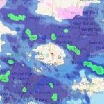
This did work out for some areas of the upper Eastern Shore last evening. Chesapeake City with over 2 inches, my location with 1.50 inches.
-
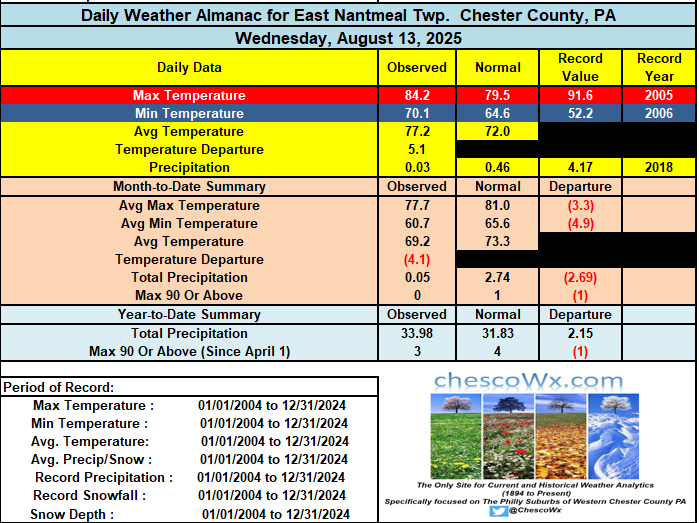
Most folks across the north and west parts of the county saw little rain (under 0.05")....much different across other spots with West Grove 1.39" / Nottingham 2.33" / Avondale 1N 0.55" / Kennett Square 1.26" / Devault 1.70". We do have a chance at some more showers this afternoon. Mainly dry and sunny weather looks likely for the weekend. Of note most spots across Chester County have not experienced any days over 90 degrees so far here in August. The exceptions were West Chester and Devault yesterday. Most spots in the county look to have potentially their next shot at a 90-degree temperature on Sunday with highs well into the 80's. As we move through next week temperatures begin to cool back down to not far from normal levels with some higher spots seeing highs mainly in the 70's by mid-week.
-
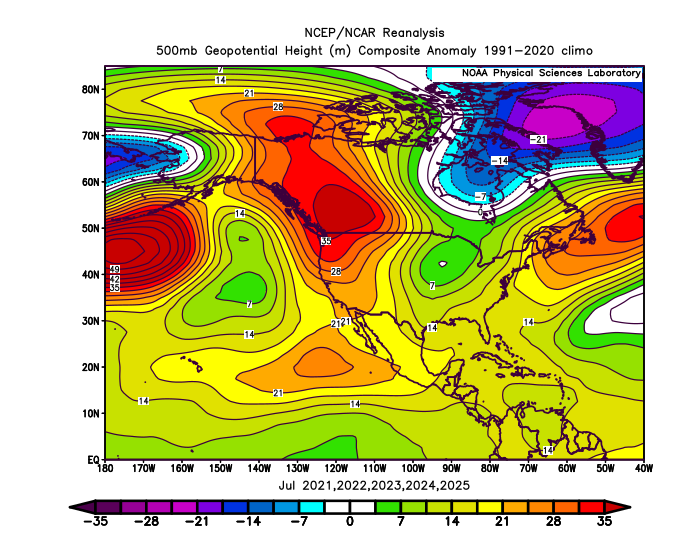
There has been a new relationship between the -PDO and PNA especially during the 2020s summers. This was our first July streak of 5 consecutive -2 to -4 -PDOs. There has been a very strong +PNA signal leading to the record wildfires, record heat, and drought up in Canada. Past instances of -2 -PDOs in July were more -PNA. My guess is that this is related to the -PDO being more driven by the warmer SST anomalies than the colder ones which used to dominate -PDOs in the past. Recent July -2 to -4 -PDOs have been more +PNA Older -PDO below -2 in July were more -PNA
-

E PA/NJ/DE Summer 2025 Obs/Discussion
ChescoWx replied to Hurricane Agnes's topic in Philadelphia Region
Most folks across the north and west parts of the county saw little rain (under 0.05")....much different across other spots with West Grove 1.39" / Nottingham 2.33" / Avondale 1N 0.55" / Kennett Square 1.26" / Devault 1.70". We do have a chance at some more showers this afternoon. Mainly dry and sunny weather looks likely for the weekend. Of note most spots across Chester County have not experienced any days over 90 degrees so far here in August. The exceptions were West Chester and Devault yesterday. Most spots in the county look to have potentially their next shot at a 90-degree temperature on Sunday with highs well into the 80's. As we move through next week temperatures begin to cool back down to not far from normal levels with some higher spots seeing highs mainly in the 70's by mid-week.
-
Looks like the cool down starts Monday.
-
 Same in northern Westchester!
 -
1.7" in Akron yesterday. Funny thing is that it didnt "feel" like that much. Ida guessed half of that tops. Happy pre Friday all.
-
 .28 imby..not impressed
 -

2025-2026 ENSO
40/70 Benchmark replied to 40/70 Benchmark's topic in Weather Forecasting and Discussion
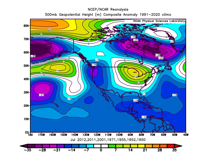
Yea, the PDO and PNA part ways relatively frequently, as was the case last season. This is probably why the PNA in many of my analogs isn't as negative as you seem to think.


.png.e1c4baae78d7347e65e49f6942a1c8fb.png)


