All Activity
- Past hour
-

December 2025 regional war/obs/disco thread
mahk_webstah replied to Torch Tiger's topic in New England
Surprisingly nice event here. As of this morning, we were supposed to have a little bit of snow mixing and then totaling less than 1 inch. As it has happened, we have nice snow growth fluffy accumulating snow. At 2 inches now it’s still coming down steadily 28°. An over performer and a few degrees colder than predicted. Let that be our trend this winter. -
We're this close to greatness. Wow that's actually impressive coming from you. You've always struck me as a person that hedges warmer.
-

December 2025 regional war/obs/disco thread
SnowGoose69 replied to Torch Tiger's topic in New England
The ICON I swear has ideas close to the end result on some events in the 120-150 range when the GFS/CMC are just totally lost but it might just be selective memory by me or the fact at that range its made a few hits and I remember them. The NAM used to have biases/tendencies at 72-84 that gave you a feel for things but its been a good 8-10 years now since those worked. I think upgrades to it ended that and now it often just shows oddball things but I can never find consistent biases anymore like I used to. -
I'm actually pretty bullish on colder this Winter.. at least one of the better Winters in the last 10 years. The models made a huge shift to warm over the last few days though.. Polar Vortex in northern/NW Canada really pops the SE ridge here in the 2nd half of December. Here's a post I just made about it in the ENSO thread: Yeah, pretty big warm up on the GFS ensembles. +NAO gets going in the next few days, and the -WPO transitions into a pattern where the PV is in northern/NW Canada. Natural Gas moved from $5.50 to $4.50 in a few days, over the last few days. It actually led models shifts by about 2 days. I just think that is so interesting. I wonder if Ray's January warm up is happening early? I do think in the longer term we have tendency for -AO/-EPO but that may not be until after or around Jan 1.. Stratosphere warming in Nov wasn't super strong, but that is a possible -NAO the last week of Dec, if the cooler pattern is going to move back in early. we'll see. After the clippers the next few days, I don't really see any threats for snow until around Jan 1st.
-
18z EPS a tick better. The euro was very close to a better solution with the sw a bit more south and west.
-

December 2025 regional war/obs/disco thread
codfishsnowman replied to Torch Tiger's topic in New England
MTK to BID special...that's somewhat rare. Be pretty cool though. -
Ya ripping under this
-
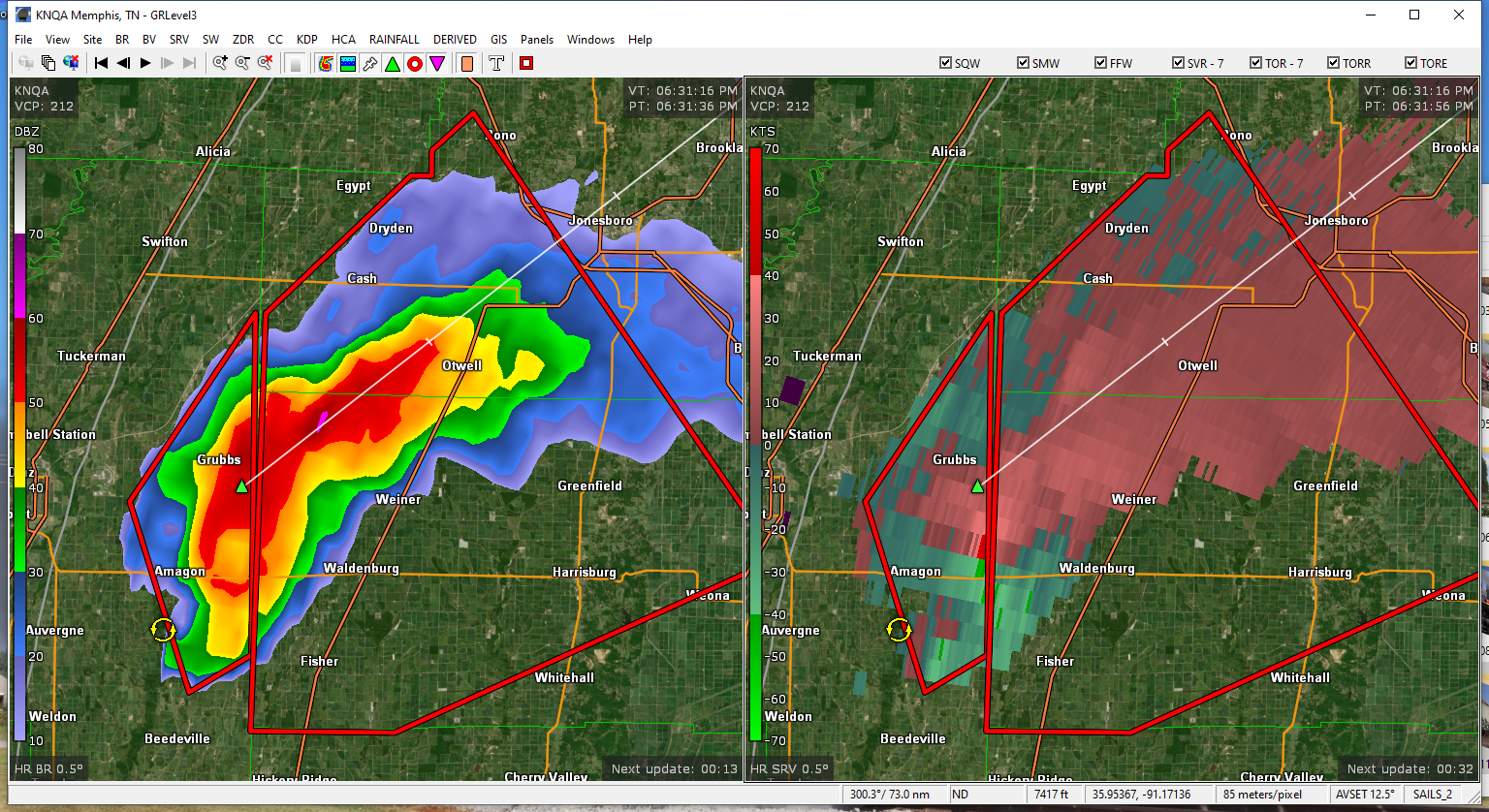
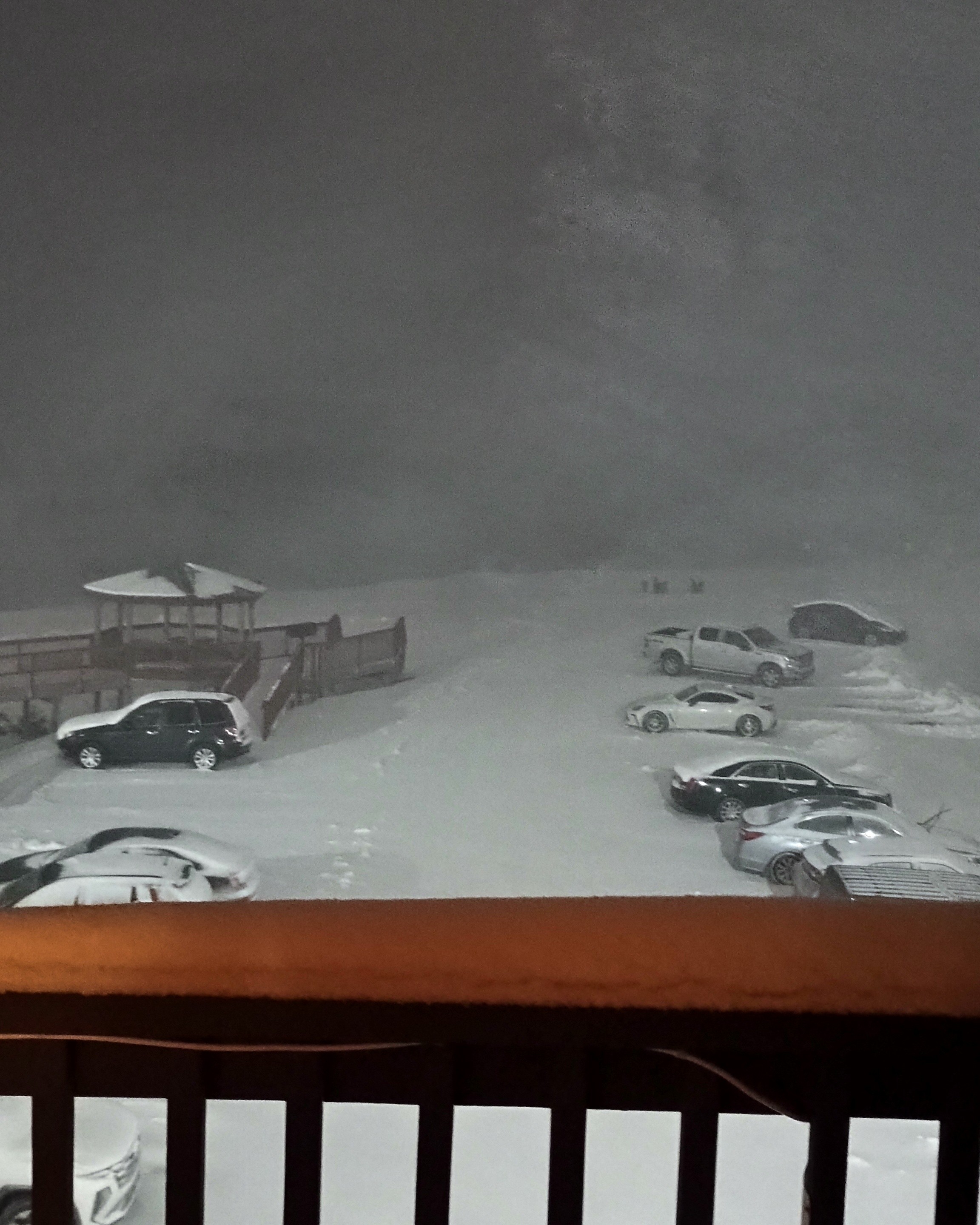
Good 4" or so in Jackman.
Scaled(63).thumb.png.e6fa7b5d659ac10672c976eed323f413.png)
-

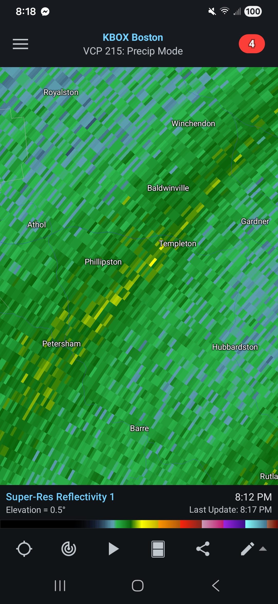
December 2025 regional war/obs/disco thread
HoarfrostHubb replied to Torch Tiger's topic in New England
Looks like snowing mixing in at Wachusett. -
Things have finally picked up. In the past couple of minutes, two incredibly loud claps of thunder occurred. The only other time I've experienced this was during a LES event off of Erie a few years ago. It sounded just like something you'd hear during the summer. Very, very cool. Maybe about a half-inch so far.
-
mod snow here now fat flakes
-
1-3” possibility Sunday followed by a drop into the teens that night sounds great.
-
Can't believe I'm saying this, but I put more stock in the CMC or mid trance NAM for trends over the ICON
-

Winter 2025-26 Medium/Long Range Discussion
CheeselandSkies replied to michsnowfreak's topic in Lakes/Ohio Valley
4 years ago OTD...
-
12z gfs… 65-70 degrees Christmas Eve 18z gfs… 6-12+ storm for the MA and NE on Christmas Eve Safe to say models have minimal clue how our pattern will unfold in 2 weeks
-

December 2025 regional war/obs/disco thread
WinterWolf replied to Torch Tiger's topic in New England
Ya, I find it hilarious he said the Icon. Like the icon is something to consider. -
December 2025 regional war/obs/disco thread
HoarfrostHubb replied to Torch Tiger's topic in New England
It would cut back on the bitching ineedweenies and I will get ours… -

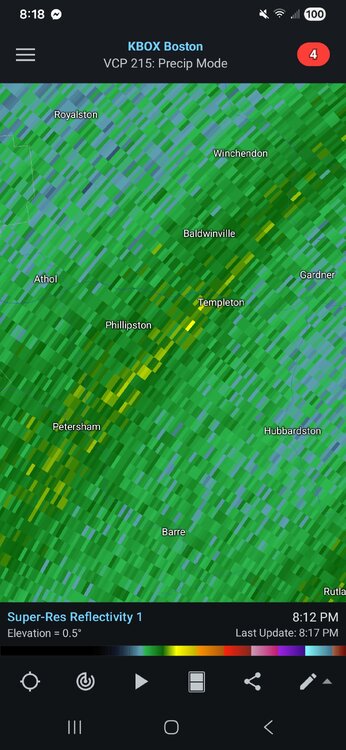
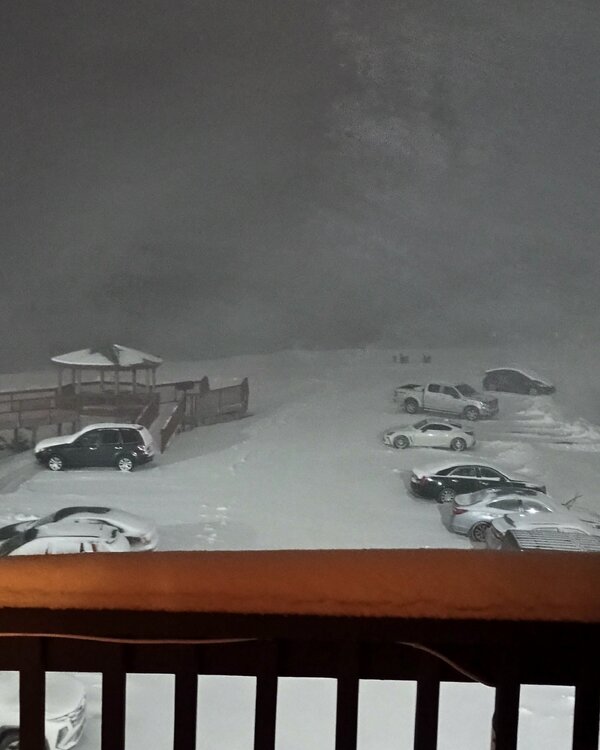
2025-2026 Fall/Winter Mountain Thread
Buckethead replied to Buckethead's topic in Southeastern States
Lightning strikes in the approaching line! Sent from my Pixel 10 Pro using Tapatalk -
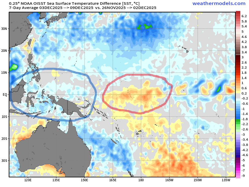
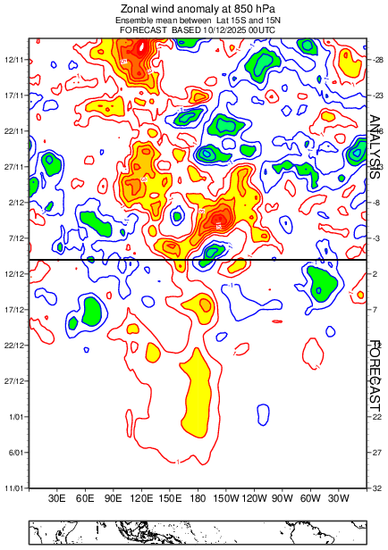
Yeah, this warm pool facet of how things are evolving this year is pretty fascinating. Eric Webb had even made a mention of this idea near the beginning of the month too. I mean... we legitimately could be attempting to pull off something exactly like that... Already, over the last 7 days there's been warming and cooling of sst's in all of the right places (1st image). Plus with an outlook favoring some persistent wwb's right around the dateline (2nd image). In the near future and for the seemingly foreseeable future. With that warm pool currently leaning a little to the east already too. Sure sounds a lot like the proper recipe for continuing to see good things evolve out there in the wpac.
-
It's getting fun
-

December 2025 regional war/obs/disco thread
Kitz Craver replied to Torch Tiger's topic in New England
Scooter approved -
A very pretty 1.3" here as the temp sat right at 32F for most of the day. It's certainly been a wintry month so far
-
LOL is right, same as citing the NAM at this range... without caveats
-

December 2025 regional war/obs/disco thread
moneypitmike replied to Torch Tiger's topic in New England
The faux-sympathy is palpable. -

December 2025 OBS and Discussion
coastalplainsnowman replied to wdrag's topic in New York City Metro
I'd love to know how strongly correlated a snowfall prediction 360 hours out is to actual results. I know we like to joke that if it's on there at 360 that's bad because that means it won't happen, but it's probably just a wee bit better to be in the jackpot 360 hours out than for it to be showing no storm? Or is the correlation so weak as to be negligible? At what point is it better than negligible? 10 days? 8 days? I imagine those results exist somewhere? When I'm retired someday I'm going to have a lot of fun messing around with this sort of data.


.thumb.JPG.418e8a9a2902ae687ec35ff4bc0e038e.JPG)