All Activity
- Past hour
-
Everyone has their own subjective likes and dislikes when it comes to the weather. I liked cooler and wetter in the summer when it used to keep the big beach crowds away from Long Beach. Since finding parking spaces was always a challenge there. So 1996 and 2009 are two of my favorite summers living in Long Beach. I didn’t mind having several days which were compete washouts since all the perfect days in the 70s made up for it.
-
up to a gorgeous 73 here - bright sunshine.
-
There's a diffused re-enforcing cool front passing through ( because we need more cold of course...). The wind gusting has slacked off here in the last 1/2 or so hour so it might've been a transient aspect of that feature.
-

-
Wow you're not kidding. Just got some pretty decent gusts all of a sudden. Guessing we must have just reached ~850mb for mixing level.
-

Central PA Spring 2026 Discussion/Obs Thread
canderson replied to Voyager's topic in Upstate New York/Pennsylvania
72 and haze sunny at noon -
Only of he quits. Lol
-
Another great day out there. In the "bad" pattern lol
-
-
-
61° here. It feels like 81° after what we've been having.
-
Not for me
-
Last week was Mother Nature cracking up at us.
-
56/32 FEW Not a bad day out there although there’s some rogue good gusts at times.
-
Smoke is visible in this area due to the S GA fires.
-
why? i understand winter is your thing but constant grey 50's with rain and wind is just gross
- Today
-
I would live in Thule, Greenland and eat fermented whale blubber all day before I’d live down there.
-
Probably not. This year is probably the polar of 2020. That year, we had an ending weak +ENSO that transitioned into a solid la nina, and a developing -PDO. This year, we have an ending weak -ENSO that looks like it's transitioning to a strong, if not super, el nino, and an ending -PDO/developing +PDO. Plus, 2019-20 was a very warm and virtually snowless winter that turned cold in April into May, while this winter was cold and snowy, that turned warm in March, and flipped to a torch around Daylight Saving Time.
-
63 and bluebird sky. Beautiful day!
-
Ha ha ha that’s all right. I knew I was going to incur the wrath just by bringing it up.
-
Music to my ears
- 806 replies
-
- 1
-

-
- april showers bring may..
- rain
- (and 2 more)
-
Want to switch ?
-
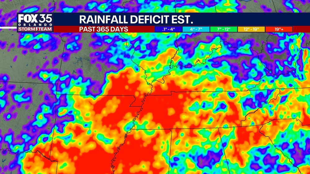
Found this on FB from a local news station in Orlando showing 365 day rainfall deficits. I found it very interesting that the location of the August 2025 flash floods over eastern Hamilton county is very apparent. That was the only significant rainfall in this corner of the state for months.
-
Yep it is bad throughout the Southeast.
-
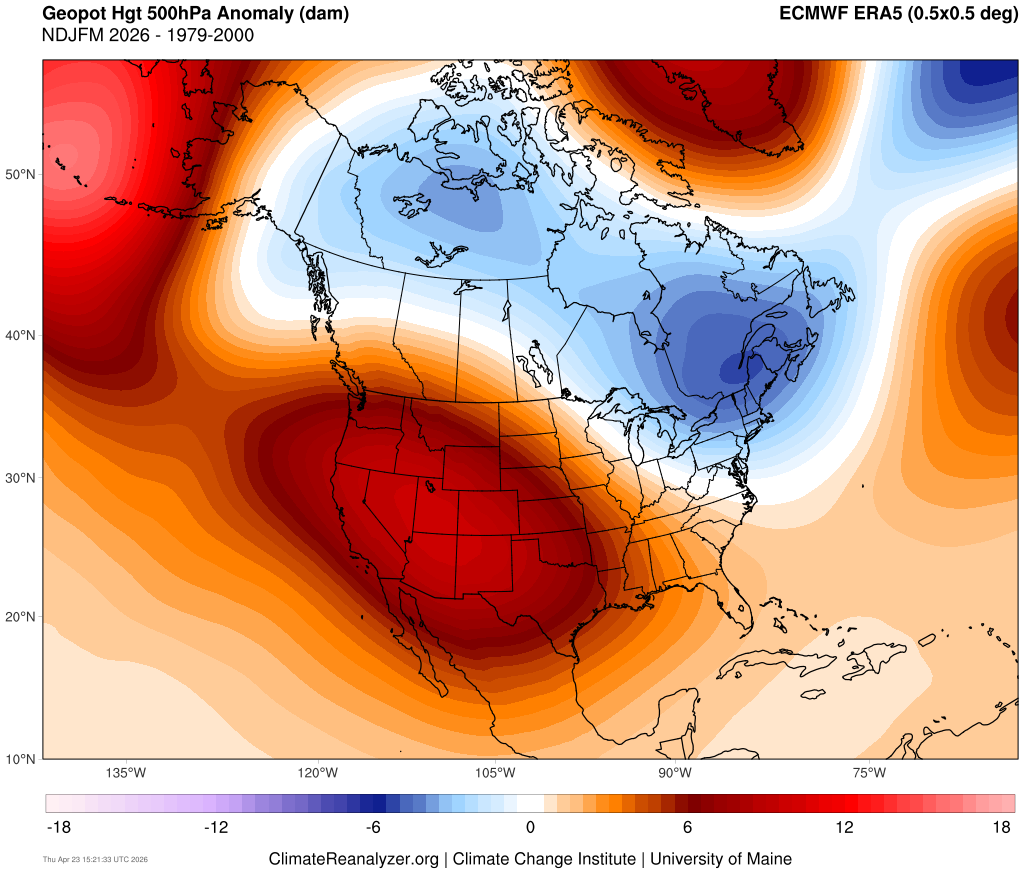
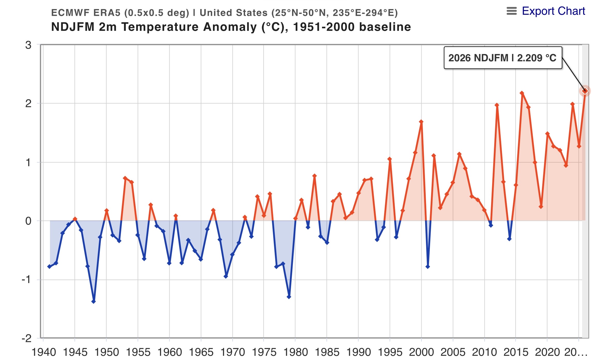
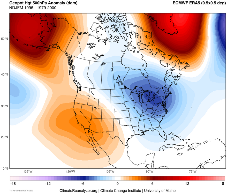
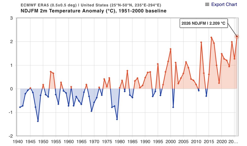
There are a few ways of looking at this. If you use a linear model, then you would be correct. But a non-linear process involving threshold temperarures of marine heatwaves potentially driving the forcing leading to that record breaking ridge would be a different case. The ridge out West was much stronger from November to March this year than the similar weak La Niña in 1995-1996. Such an increase could be the result SST forcing thresholds being met and the pattern becoming much more amplified and locking in over a longer duration. So rather than a gradual increase in temperatures and 500mb ridging, the warmer background pattern resulted in more of a jump. The CONUS was actually slightly colder in 1995-1996 instead of the warmest November to March on record in 2025-2026. There wasn’t the extended record warmth out West over the same period back in 1995-1996. https://agupubs.onlinelibrary.wiley.com/doi/full/10.1029/2022GL101499 Circus Tents, Convective Thresholds, and the Non-Linear Climate Response to Tropical SSTs Using model simulations, we demonstrate that the climate response to localized tropical sea surface temperature (SST) perturbations exhibits numerous non-linearities. Most pronounced is an asymmetry in the response to positive and negative SST perturbations. Additionally, we identify a “magnitude-dependence” of the response on the size of the SST perturbation. We then explain how these non-linearities arise as a robust consequence of convective quasi-equilibrium and weak (but non-zero) temperature gradients in the tropical free-troposphere, which we encapsulate in a “circus tent” model of the tropical atmosphere. These results demonstrate that the climate response to SST perturbations is fundamentally non-linear, and highlight potential deficiencies in work which has assumed linearity in the response.


.thumb.gif.f92b16c631a1d15d405ed77b33f0710d.gif)