All Activity
- Past hour
-

Hurricane Erin: 140 MPH - 937 mb - NW @ 10
wthrmn654 replied to BarryStantonGBP's topic in Tropical Headquarters
Gfs another noticeable shift west and north.... lol this reminds me of winter storms the past few years non stop shifts... -
That's a monster hit sucks it's 10 days out
-
Ya can we just lock that in now lol
-
Doesn’t mean much of anything for us: meh. But looks like you initialized the next storm lol.
-
Drunk
-
Cocgust!
-
 74 for high Coldest day since 69 on 6/27 8 day heatwave comes to a crashing end
 -
Congrats @dendrite
-
Mt Holly disco not buying into much significance of any rain
-
 They were taking everything off the beach in LBC
 -
IMO, there is a high risk for a dry met fall (SON) again this year. I don’t think we see a record drought like last fall, but I can see us reach drought conditions none the less
-
End of the month looking nice too.
-
ALB to Dendy congrats on heavy rains Wednesday
-
No it’s not. In fact, a La Niña Watch was just issued by the CPC/NOAA
-
GFS with the shift west.. ICON FTW?
-

Hurricane Erin: 140 MPH - 937 mb - NW @ 10
Eskimo Joe replied to BarryStantonGBP's topic in Tropical Headquarters
Already have water overwashing lower Assateague Island. -
Isn't nina looking less and less likely? Almost looks like a carbon copy of last winter (which was good for mid atlantic but meh for philly-nyc-coastal new england).
-
Scoot lives in South Wey though
- Today
-

2025 Spring/Summer Mountain Thread
Maggie Valley Steve replied to Maggie Valley Steve's topic in Southeastern States
For the second day in a row we've had storms nearby, nothing at the house. A weak cold front isoving through and we're 35 days until Fall arrives. Perhaps someone can start our Mountain Fall/Winter discussions. It won't be long! -

Spring 2025 Med/Long Range Discussion
KakashiHatake2000 replied to John1122's topic in Tennessee Valley
oh okay gotcha thank you daniel boone at least it will be better than the temps we have now im guessing they change the climatology maybe every decade or something i guess but good to know -
Nice work
-
Their extended outlook has nothing dramatic for this time of Year. Cooler but nothing extreme. However, Model Data is showing cooler but nothing of Tecord proportions. NWS is adjusting to Climatology , so their extended Outlook will be warmer than Guidance.
-
Midnight high for MBY.
-
Hurricane Erin: 140 MPH - 937 mb - NW @ 10
wthrmn654 replied to BarryStantonGBP's topic in Tropical Headquarters
Consensus model has shifted both north and west this time around! The amount of shifting past few days is remarkable! Euro cmc, and even some of the more reliable hurricane models had a decent shift west/ north at 12z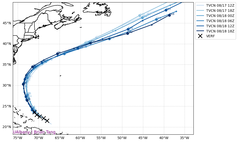
-
yeah and the average Joe doesn't realize it's fake-what a dumpster fire.


