All Activity
- Past hour
-
St. Louis area (Belleville IL) had 96/79/114.3
-
The problem is the questions are not asked in good faith. There is an agenda. You have to identify things like this because it is designed to suck away your attention span. https://en.wikipedia.org/wiki/Firehose_of_falsehood This is a well known propaganda technique. It is designed to exhaust you until you just waive the white flag.
-
.thumb.png.4150b06c63a21f61052e47a612bf1818.png)
July 2025 Obs/Disco ... possible historic month for heat
HIPPYVALLEY replied to Typhoon Tip's topic in New England
Agree but I think it is more a Worcester to Cape Cod deal. -
I know there was some discussion about PIT and AGC maybe running warm at times last year, but it definitely seems to have been corrected. Arguably running a little on the cool side this year compared to surrounding observations, especially AGC. The official tally might have this July cooler than last, but overall it's been a bit warmer just about everywhere in the region (especially with the overnight minima).
-

July 2025 Obs/Disco ... possible historic month for heat
Typhoon Tip replied to Typhoon Tip's topic in New England
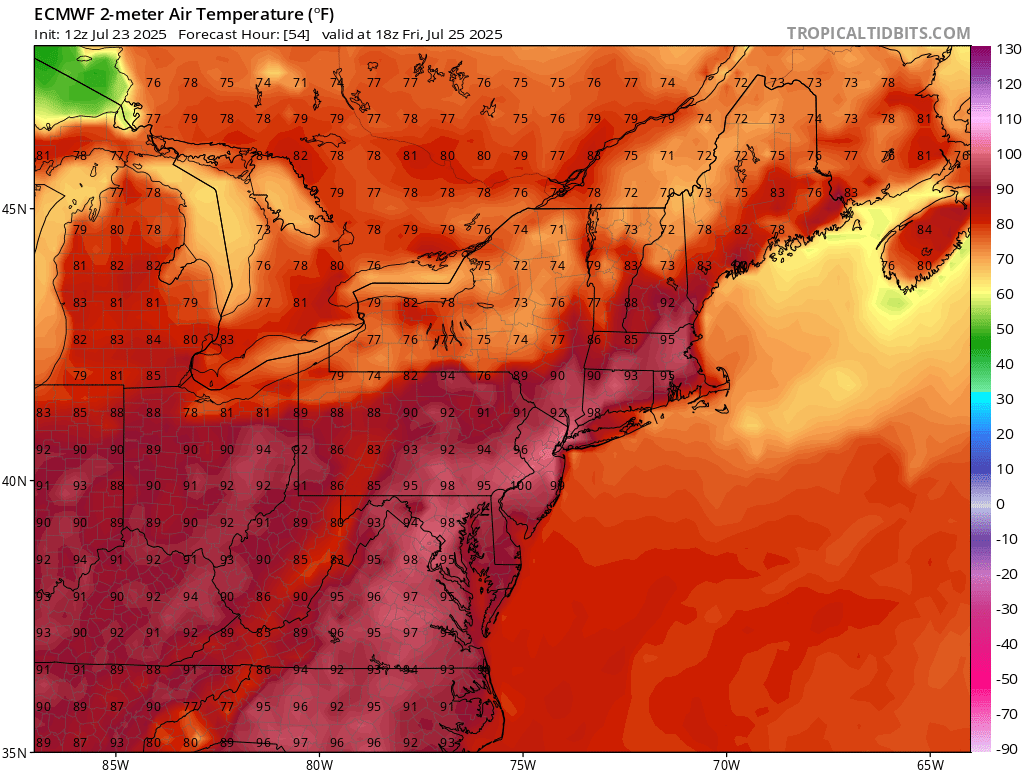
Man. Big heat Friday on this NAM run -
HA! He was born in Hoboken. If he heard you call him a Southern Gentleman he would have been quite amused.
-

July 2025 Obs/Disco ... possible historic month for heat
Brewbeer replied to Typhoon Tip's topic in New England
took out two nests in the lawn the past two nights -
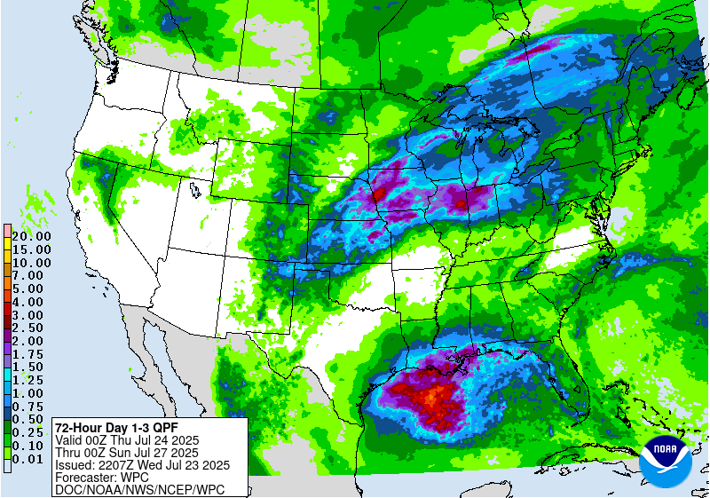
Decent heavy rain/flood potential starting tomorrow night through Saturday for Northern Illinois and Indiana.
-
Please tell me it extends to the next weekend, lol
-
Table attached below shows the difference between mean low temperature for 1st 22 days of July 2025 versus mean low temperature for July 2024. 51 sites have data for both years. Missing data not a significant factor, only 7 of the sites have more than 3 days missing through the 1st 22 days of the month. It is a factor for some individual sites, e.g. Pike Island shows an 8.7F increase but had 15 missing days in July 2024. 49 of 51 warmer. Exceptions: Donegal 2NW Coop, bizarrely 3.3F cooler, and DUJ Airport, 0.5F cooler. The mean difference is +3.2F across the 51 sites. 4 of the 6 smallest increases are the airport sites - DUJ (0.5F cooler), AGC (1.0F warmer), MGW (1.4F warmer), and PIT (1.7F warmer). Compared to the mean (average) change across the 51 sites, DUJ is 3.7F cooler, AGC is 2.2F cooler, MGW is 1.8F cooler, and PIT is 1.5F cooler. The smaller airfields seem to be unaffected. AFJ is +5.6 for the year on year (or 2.4F warmer than the mean change) and BTP is +4.1F for the year on year comparison (or 0.9F warmer than the mean change).
-
With the big pattern change at some point later next week, ushered in with a strong cold front, you would think that the chances of severe are quite high. But it could be more of a saggy cold front that sometimes doesn't work well here for severe. Definitely has my interest, though.
- 1,310 replies
-
- 1
-

-
- severe
- thunderstorms
- (and 2 more)
-
The cooldown for the first weekend in August looks legit - very strong ensemble agreement across modeling systems.
-
I don't know what's going on with the airport thermometers this year. It's bizarre. Like all the airports dropped 2-3F, every single one of them? Especially AGC and HLG. They went from one of the warmest spots in the PBZ CWA last July to among the coldest by mean maximum temperature this year? AGC has suddenly become one of the coldest spots in the entire CWA outside of some high mountain sites for daily high temperatures. PIT airport went from 1.7F warmer than the Moon Township COOP in July 2024, to 0.9F colder this July. The lows are still warmer, but they have dropped a bunch too relative to the COOP sites. Last year, 4 airport sites had the warmest daily low temperatures in July. This year, the highest is like 5th of all sites.
- Today
-
Today’s Euro Weeklies had a large increase vs yesterday for the week covering 8/18-24. Yesterday’s run for 8/18-24: Today’s run:

-
The state championship for the Geography Bee was being held there. It was a middle school competition. Sort of like the Spelling Bee. If I had made the national championship I would have seen Alex Trebek as he was the host of the event! My dad was wondering if we'd be able to make it but it worked out in the end. I remember leaving home with nothing on the ground and then seeing my first glimpse of a coating here or there somewhere between New Rochelle and White Plains. The Catskills got smoked so there was still a ton of snow on the ground even a couple days later.
-

July 2025 Obs/Disco ... possible historic month for heat
HoarfrostHubb replied to Typhoon Tip's topic in New England
August could rock in this regard. -
July 2025 Obs/Disco ... possible historic month for heat
HIPPYVALLEY replied to Typhoon Tip's topic in New England
I’ve never experienced a summer in W MA with so little thunder. It’s actually the one thing we do best in New England and it has just been so benign. -
July 2025 Obs/Disco ... possible historic month for heat
HIPPYVALLEY replied to Typhoon Tip's topic in New England
So far it’s been a fairly hot and humid summer but with enough mild downs to keep people sane. It certainly has not been an exciting summer and for the few that are expecting a major hurricane to hit SNE, good luck with that. I think the hurricane season is going to become Gulf Coast centered by September. -
Many Prayers
-
The current squall line over Northern Lower is more impressive than expected. The southern outflow boundary might act to really concentrate the steam flowing up from Illinois. I don’t see those dewpoints mixing out so easily this time.
-
RIP JBurns
-

2025-2026 ENSO
PhiEaglesfan712 replied to 40/70 Benchmark's topic in Weather Forecasting and Discussion
13-14 and 14-15 were wall-to-wall winters, or at least very close. Both were very cold and snowy from at least January to March, with each having a cold November, and 13-14 a taste of winter in early December (before a 2nd half of the month thaw). 08-09 definitely felt like a longer winter than 09-10 and 10-11. It's just that the cold and snow didn't come hand-in-hand. The cold was there in October-January, but the two snow events happened in early February (this one was more isolated) and early March (the Nor'easter). Of course, 15-16 was saved by the massive snowstorm. Otherwise, it would have been another warm and snowless winter that has become more commonplace since 11-12. -

July 2025 Obs/Disco ... possible historic month for heat
kdxken replied to Typhoon Tip's topic in New England
Not even close for the month. Boston is 17th and Worcester is 13th. I guess if you throw out the two biggest cities in New England it was pretty hot in brimfield and shutesbury lolz.. -
July 2025 Obs/Disco ... possible historic month for heat
kdxken replied to Typhoon Tip's topic in New England
Stay in the sun. Give it a try. -
Friday looks like a good time.