All Activity
- Past hour
-

February 2026 Medium/ Long Range Discussion: Buckle Up!
high risk replied to Weather Will's topic in Mid Atlantic
AI models don't do particularly well with QPF. They get a general shape of the field but struggle to resolve amounts and detail. I'd focus far more on 500 heights and SLP. -

Possible coastal storm centered on Feb 1 2026.
Roger Smith replied to Typhoon Tip's topic in New England
If anyone from NS looks in, BOOM !!!! 40-60 cm potential, the low explodes and tracks ideally to bring S++ bands across the province. Cape Breton could see highest totals. Parts of Newfoundland could see 20-40 cm. These amounts will be wind-blown by northeast 70-110 km/hr winds. Temps near -5 C. At this late hour I still think there is some potential for the outer bands of this storm to back into parts of e MA, there has been a trend towards a deeper-digging 500 mb low over SC now, and you have to wonder if there might be a slow last-minute trend towards backbuilding this storm slightly, but wow such a waste of excellent ingredients unless you are of course in Nova Scotia (Sunday night into Monday Feb 2nd). -

Central PA Winter 25/26 Discussion and Obs
pasnownut replied to MAG5035's topic in Upstate New York/Pennsylvania
as you /we know, many times we score during times of relaxation of trough/nao blah blah. Enough showing that I'd thin suppression depression will work its way back to MA/NMA instead of the carolinas. -

February 2026 Medium/ Long Range Discussion: Buckle Up!
Heisy replied to Weather Will's topic in Mid Atlantic
The Ai models shouldn’t really be used for QPF for this reason. H5? Different story. -

The “I bring the mojo” Jan 30-Feb 1 potential winter storm
Kraychav replied to lilj4425's topic in Southeastern States
Yep -

Jan 30th-February 1st 2026 Arctic Blast/ULL Snow OBS Thread.
BKinLenoirCity replied to John1122's topic in Tennessee Valley
Nothing in northern loudon county. I’m about 3 miles from Farragut line. Hopefully it gets here! Schools are already closed for Monday! . -
February 2026 Medium/ Long Range Discussion: Buckle Up!
Heisy replied to Weather Will's topic in Mid Atlantic
I know verbatim the gfs didn’t work out, but it did trend like the Ai, slowing down the wave and shifting ridge W. If this thing is going to come up the coast that’s a good way to start so I’ll take it as a positive overall. -
Central PA Winter 25/26 Discussion and Obs
pasnownut replied to MAG5035's topic in Upstate New York/Pennsylvania
unfortunately that happens when big cold snaps hit. but fortunately we got hit with a great event prior to, and have lost almost no snowpack. Took the sled out for an after work rip in the fields, and this shit is legit solid. Further compaction when we moderate next week could set the stage if we get more snow to follow, for a memorable stretch of snow days w/ 1" or more otg. -

The “I bring the mojo” Jan 30-Feb 1 potential winter storm
IceQueen706 replied to lilj4425's topic in Southeastern States
Yes. -

The “I bring the mojo” Jan 30-Feb 1 potential winter storm
NYweatherguy replied to lilj4425's topic in Southeastern States
I am from Upstate NY but have lived in Buford, GA for 15 years. I expect to get 2-4, but we shall see! -

2025-2026 Fall/Winter Mountain Thread
Tyler Penland replied to Buckethead's topic in Southeastern States
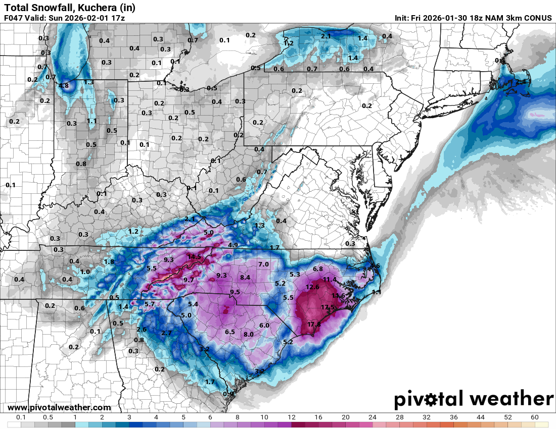
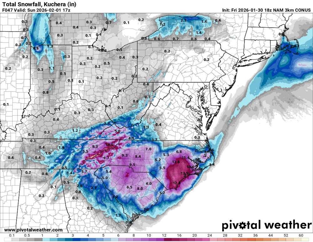
Here's the whole run. Up to nearly a foot for Boone now. -

The “I bring the mojo” Jan 30-Feb 1 potential winter storm
USCG RS replied to lilj4425's topic in Southeastern States
This. We need more of this from meteoroligcal outlets. -
It's only through 1 p.m. tomorrow. Here's through 1 p.m. Sunday. Also adds a good thumping of NWFS for the mountains.
-
 https://x.com/katcampbellwx/status/2017356148890890363?s=46
 -
Some melting is happening but not enough.
-

1/30-1/31 Lake Effect Snow Threat - SE WI, NE IL, and NW IN
ILSNOW replied to A-L-E-K's topic in Lakes/Ohio Valley
ended up with just under 2 inches here for round 1 lake effect has moved back in prolly get another inch -
We don’t cut the flower beds back until spring so that the birds and the critters can enjoy them. We also have multiple birdfeeders throughout the backyard. It’s great for this time of year.
-

Central PA Winter 25/26 Discussion and Obs
canderson replied to MAG5035's topic in Upstate New York/Pennsylvania
Storm so suppressed it’s moving too far east to push stronger ones to us (thankfully) -
The “I bring the mojo” Jan 30-Feb 1 potential winter storm
Roger Smith replied to lilj4425's topic in Southeastern States
Here's how I would expect this to play out, first an interval of light to moderate snow mostly inland NC-SC-ne GA as the 500 mb low begins to deepen over GA, then an interval of heavy bands of snow along the Carolina coasts from roughly New Bern to Savannah, possibly two parallel bands with local snow maxima of 12-18 inches. Ongoing lighter snow further inland brings totals to about 6 inches. Southeast VA and northeast NC have more uncertainty, they could have an interval of blizzard like heavy snow, or the coastal may pull away too far south and too fast to give them more than 3-5 inches. Temperatures in the low to mid 20s during this snow, a few bands in eastern GA with slightly higher temps could see hail mixed with snow. Looks increasingly likely that some local bands of 0.5 to 1.0 inch snow could fall in n/c FL also. There are a lot of small to medium sized lakes there to enhance shower clouds, and temperatures by late Saturday will be below freezing as far south as Tampa to Space Center and low to mid 40s in s FL. Crazy man! -

The “I bring the mojo” Jan 30-Feb 1 potential winter storm
PenguinLover replied to lilj4425's topic in Southeastern States
Same here, I'd take those few inches of snow for me and run at this point. -

Jan 30th-February 1st 2026 Arctic Blast/ULL Snow OBS Thread.
bearman replied to John1122's topic in Tennessee Valley
Ok we got what I would call steady light snow. -

Richmond Metro/Hampton Roads Area Discussion
wasnow215 replied to RIC Airport's topic in Mid Atlantic
Both AI's slightly north-18z -

February 2026 Medium/ Long Range Discussion: Buckle Up!
T. August replied to Weather Will's topic in Mid Atlantic
Agreed… too much smoothing. Almost ensemble-esque -
Richmond Metro/Hampton Roads Area Discussion
wasnow215 replied to RIC Airport's topic in Mid Atlantic
We will see about that and how the models are handling the low placement etc. Won't know til nowcasting. -

The “I bring the mojo” Jan 30-Feb 1 potential winter storm
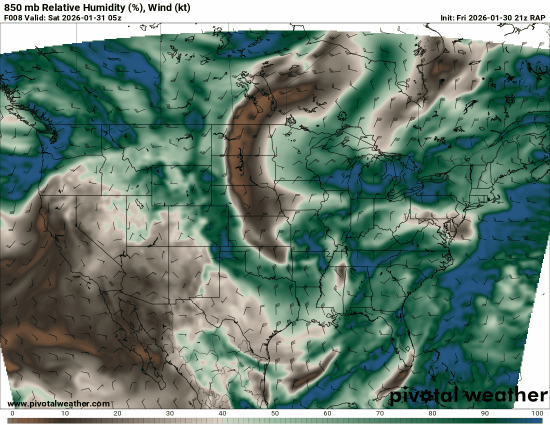
Snowncanes replied to lilj4425's topic in Southeastern States
The RAP dry slot can be seen here. Im not sure I would really buy into that not being moist enough for snow growth. Not sure why there’s that tiny dry pocket either. Maybe a Met could explain better than me. I think the HRRR likely has something similar going on.