All Activity
- Past hour
-

Occasional Thoughts on Climate Change
TheClimateChanger replied to donsutherland1's topic in Climate Change
Yeah, I've always thought it was a red herring. The Lake Erie at Buffalo average annual temperature is rising at pretty much the exact same rate as the air temperature at Buffalo. So unless UHI is pouring into Lake Erie, it would seem the temperature represents a real trend. Lake is slightly warmer because it doesn't drop below 32F in the winter due to ice. -
6z Friday on NAM: Station: KBOS Latitude: 42.37 Longitude: -71.02 Elevation: 37.36 Press Height Temp Dewpt Dir Spd SFC 1024.1 37 0.1 -0.4 51 13 M 1000.0 227 -1.0 -1.4 57 27 S 950.0 636 -2.9 -3.4 83 33 S 900.0 1066 -1.2 -1.6 96 25 M 850.0 1523 -0.0 -0.3 119 20 S 800.0 2008 -0.7 -1.0 139 20 S 750.0 2524 -1.1 -1.4 181 16 M 700.0 3073 -2.6 -3.1 219 22 S 650.0 3658 -5.1 -5.9 234 28 S 600.0 4284 -8.2 -9.2 243 35 S 550.0 4955 -11.7 -13.1 248 45 M 500.0 5679 -16.0 -17.8 251 54
-
I remember talking to Scott 4 or 5 days ago, this thing had a minimum/floor of moderate impact back then and it was kind of believable just synoptically because the feature’s playing into it were stable/predictable.
-
Let’s ice it up.
-

Spring 2026 Pattern Discussion Thread
KakashiHatake2000 replied to Carvers Gap's topic in Tennessee Valley
Gotcha thank you nrg Jeff . -
Next winter is going to suck.
-
I mean this is a very classic ice storm look for SNE, south of pike.
-
Let’s get a March 24, 1993 mini blue bomb at Logan (over 8” of pure spackle on a weak but juicy system running into a Quebec high with marginal antecedent airmass)
-
Definitely starting to notice the slow uptick in temps.
-
0z NAM continues to strengthen the push of the BDCF. If it’s right, cold sector hangs on from Thursday evening thorough Saturday evening from NoVA north and east. Front looks like gets as far SW as Lynchburg.
-
Lol I’ve seen others post similar, but I wanted to make sure each direction was covered. I might have to add that my elevation is too low to escape a warm nose haha.
-
Isothermal sounding on this NAM over Logan. NE wind 30mph pushing S/S+ rates is nasty cake at 32
-
This looks like a signiicant icing event south of pike with potential all the way down to 95. Needless to say, glad I’m largely missing this one to the north…
-
For Boston... 00z 12k NAM coming in with 6-8" 00z 3k NAM says, what snow? 00z HRRR says 4-6" 18z GFS says 4-6" 18z EURO says 4-6"
-
Ha! So excited to see it all go over the next week. Was a good winter but glad it’s pretty much over!
-
I wouldn’t get too hung up on models generating convection, and then using that as QPF distribution Thing is that these general isenreopic event types are better handled by the coarser smoothed solutions. The meth models are going to spuriously trigger convection that is completely driven by chaos in the model and then that’s gonna turn around and fuck up all the works
-
For those thinking this weather is a bit early. Wait about 10 more days and things will definitely correct course.
-
3k not nearly as good as 12k. Handling of the convection upstream seems to be jumping around.
-
NAM arrives at the party
-
Let’s get play dough
-
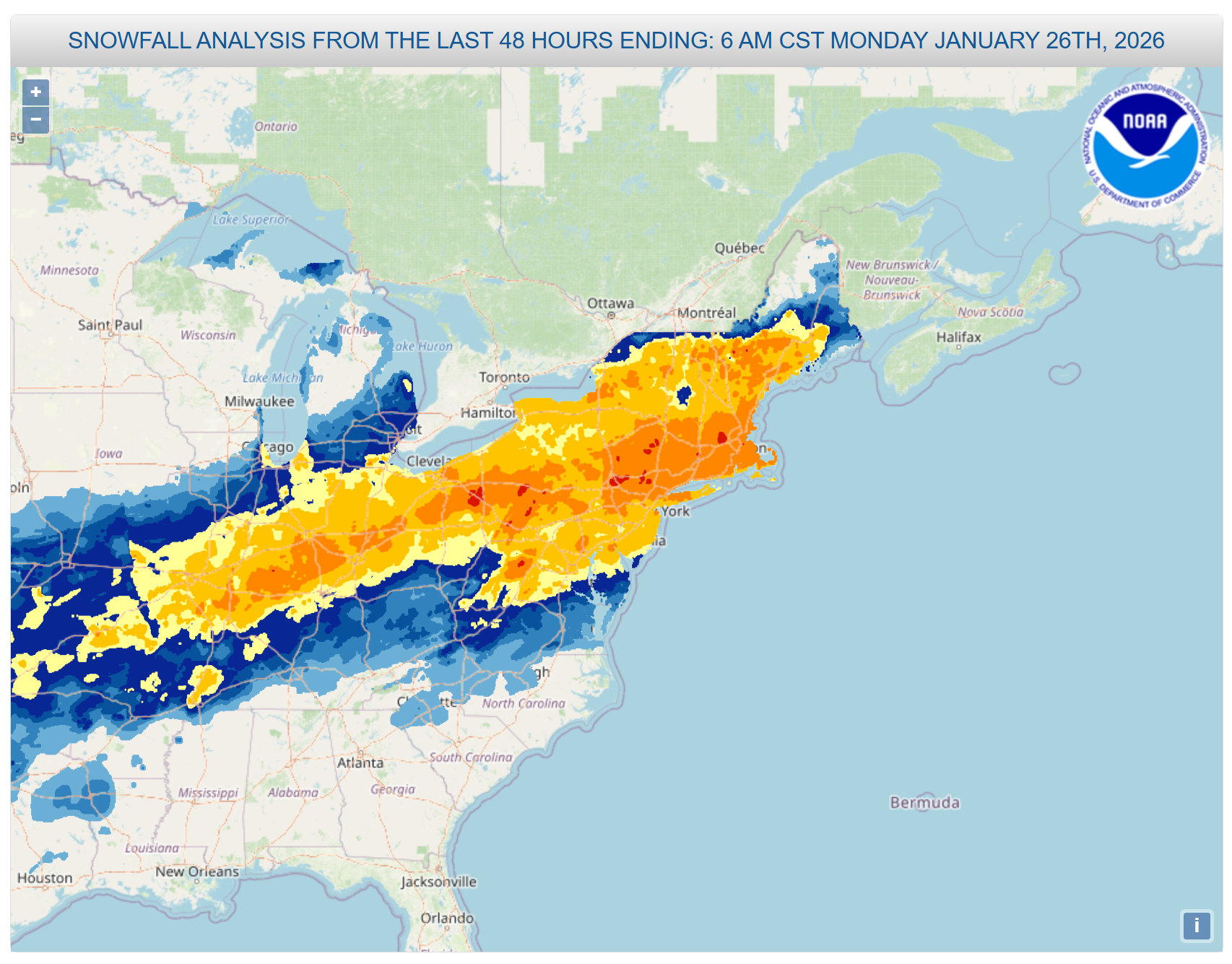
I'd still like to know when, if ever, Jan 25-26th is coming. There are some pretty puny Cat 1s in that list so i have no doubt its obviously higher than a Cat 1. Has to be at least 2 or 3. I dont know if theyll ever do it, if they skipped right over to Feb Thats a large area of 8-18 over major US cities
-
Nam going wild
- Today
-
00z HRRR says Boston sees moderate snow accumulations...not buying that at the moment. Severe gradient just to the south, little to nothing down at the Braintree split.
-
HRRR has SEMass (Plymouth and Bristol counties) radiating more than anyone tonight. Soundings for 11Z show 20˚ at the surface and 50˚ juuuust above the surface. Cranberry bog special. TAN and MVY already down to 30˚, OWD at 32˚. Cranberry bog special!
-
This is going to be one of those years where the trees are still bare on April Fool’s Day isn’t it?