All Activity
- Past hour
-
 around 1 inch of rain looks about right for here winds gusted to 40 mph there probably should have been a wind advisory and a gale warning here I noticed there was a tropical storm warning up to central NJ-- why not here Don?
 -
You called it. Getting some sun over here. Pleasant out and will eat dinner on the deck.
-
Standing on a dune near the shore still about 2 hours from high tide. Some waves lapping at the base of dunes already. Pretty sobering what would happen if/when OCMD takes a direct hit again from a major hurricane.
-
 The only stations I could find that made it to 100° from July to September in 1983 were in an around Philly. Monthly Data for July 1983 for Mount Holly NJ NWS CWA Click column heading to sort ascending, click again to sort descending. DE NEWARK AG FARM COOP 105 NJ MOORESTOWN 4 E COOP 102 PA NORRISTOWN COOP 101 MD DENTON 2 E COOP 100 PA MARCUS HOOK COOP 100 DE WILMINGTON AIRPORT WBAN 100 PA PHILADELPHIA WBAN 100 PA DREXEL UNIV COOP 100 NJ ATLANTIC CITY INTL AP WBAN 100 NJ INDIAN MILLS 2 W COOP 100 Monthly Data for August 1983 for Mount Holly NJ NWS CWA Click column heading to sort ascending, click again to sort descending. MD CHESTERTOWN COOP 101 MD MILLINGTON 1 SE COOP 101 PA PHOENIXVILLE 1 E COOP 101 PA PHILADELPHIA WBAN 101 PA DREXEL UNIV COOP 101 MD CENTREVILLE COOP 100 DE BRIDGEVILLE 1 NW COOP 100 MD DENTON 2 E COOP 100 DE NEWARK AG FARM COOP 100 PA MARCUS HOOK COOP 100 DE WILMINGTON AIRPORT WBAN 100 PA DEVAULT 1 W COOP 100 PA NORRISTOWN COOP 100 NJ HAMMONTON 1 NE COOP 100 NJ INDIAN MILLS 2 W COOP 100 Monthly Data for September 1983 for Mount Holly NJ NWS CWA Click column heading to sort ascending, click again to sort descending. PA PHILADELPHIA WBAN 102 NJ HAMMONTON 1 NE COOP 102 NJ EWING 3 WNW COOP 101 MD CENTREVILLE COOP 100 MD CHESTERTOWN COOP 100 DE BRIDGEVILLE 1 NW COOP 100 DE NEWARK AG FARM COOP 100 DE MIDDLETOWN 3 E COOP 100 PA MARCUS HOOK COOP 100 NJ SHILOH COOP 100 DE WILMINGTON AIRPORT WBAN 100 PA DEVAULT 1 W COOP 100 PA NORRISTOWN COOP 100 PA READING 4 NNW COOP 100 NJ AUDUBON COOP 100 NJ LAMBERTVILLE COOP 100
 -

2025 Spring/Summer Mountain Thread
Met1985 replied to Maggie Valley Steve's topic in Southeastern States
Amazing! Sent from my SM-G998U using Tapatalk
-
40's for western lows early to middle portions of next week.
-

2025 Atlantic Hurricane Season
BarryStantonGBP replied to BarryStantonGBP's topic in Tropical Headquarters
PACK IT UP GABRIELLE TomballEd Category 3 Posts: 832 Age: 61 Joined: Wed Aug 16, 2023 4:52 pm Location: Spring/Klein area, not Tomball Re: 2025 Global Model Runs Discussion (Out thru day 16) #753 by TomballEd » Thu Aug 21, 2025 4:36 pm Tiny bit of support for something that will follow 90L out to sea and developing in the same area on the GFS family, the Euro family has weak support for a subtropical development of the East Coast. But it still looks like dead tropics after 90L recurves. Near the peak of the season. But it comes back around mid-September. That is for the Day 16+ thread, of course. -
Yep. We can never stay out of it for long.
-
Not a drop this week.
-
INVEST 99L FORMED: (40/40)
BarryStantonGBP replied to BarryStantonGBP's topic in Tropical Headquarters
Watch the names Fernand and Gabrielle be given to SAL-choked systems -
Hoping the news about Bautista possibly being done is rock bottom, and the rest of the Birds can have a healthier 2026. Because this year has been absurd. Rutschman back on the IL again and Westburg still out.
-
Do people go to Cracker Barrel? It’s like a Disney theme park ride. You have to walk through a maze of store merchandise just to get to where you’re coming/going to.
-
We engaging in Erin clouds.
-
Nelson didn't say anything that others weren't thinking to themselves.
-
 Hopefully, a corrected figure will be provided.
 -
Cracker Barrel is over !! Just like Bud Light. The woke destroy another. Cant wait for summer to return tomorrow
-

Mid to long range discussion- 2025
WinstonSalemArlington replied to wncsnow's topic in Southeastern States
-
 BDR rain gauge must be broken-we had about 1.50 inches here
 -
18z NAM profile is near 90 Saturday BOS SW burbs/metrowest and other usuals.
-
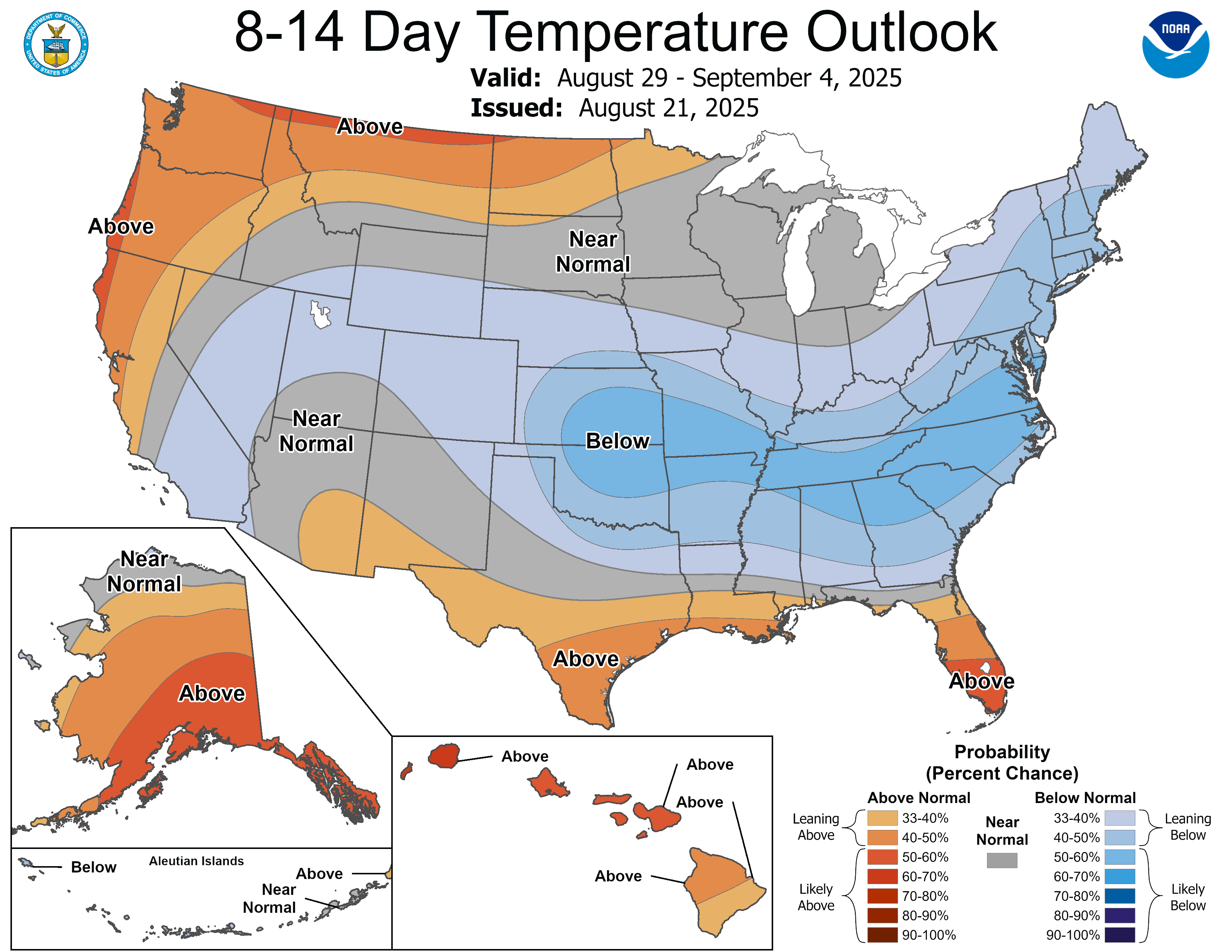
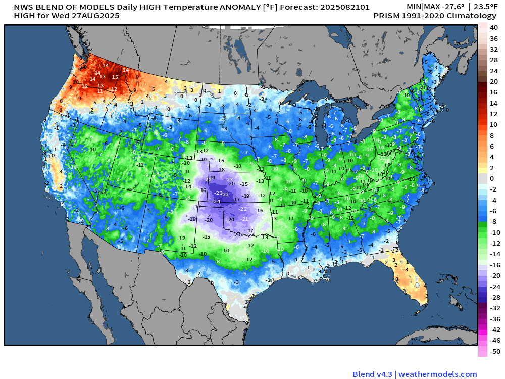
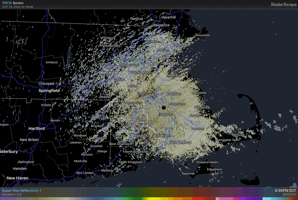
Clouds were breaking across the region this afternoon as the rain of yesterday into this morning had departed. Rainfall amounts included: Bridgeport: None Hartford: 1.52" Islip: 0.38" New Haven: 0.81" New York City-Central Park: 0.78" New York City-JFK Airport: 1.03" New York City-LaGuardia Airport: 0.53" Newark: 0.68" Philadelphia: 0.14" Poughkeepsie: 1.23" White Plains: 1.21" It will turn warmer tomorrow. High temperatures will top out mainly in the lower 80s tomorrow through the weekend. The extended range guidance continues to suggest that the closing week of August could feature below normal temperatures. Precipitation could be near normal. There will be higher-than-climatological risk of at least one period in September with highs in the upper 80s or perhaps 90s. Summers similar to the current one have had September highs of 90 or above about 10 percentage points above that for all other years. The ENSO Region 1+2 anomaly was +0.6°C and the Region 3.4 anomaly was -0.3°C for the week centered around August 13. For the past six weeks, the ENSO Region 1+2 anomaly has averaged +0.53°C and the ENSO Region 3.4 anomaly has averaged -0.20°C. Neutral ENSO conditions will likely continue into early autumn. The SOI was +1.33 today. The preliminary Arctic Oscillation (AO) was -0.858 today. Based on sensitivity analysis applied to the latest guidance, there is an implied 88% probability that New York City will have a cooler than normal August (1991-2020 normal). August will likely finish with a mean temperature near 74.4° (1.7° below normal). Supplemental Information: The projected mean would be 0.8° below the 1981-2010 normal monthly value.
- Today
-
And yet we've seen an overall decline in violent crime since the 1980/90s, despite warming temps.
-
Who said nelson isn’t free? I don’t think anyone should be banned if they are live and let live and don’t start drama. Everyone has different passions. I don’t care about heat so I just scroll past Spartsman complaining about not hitting 90 enough. Who cares. Why does the whole internet need to turn into f***ing reddit with gatekeeping?
-
June and July were wet. August has been very dry at only 19% of normal moisture thru 8-20.
-

INVEST 99L FORMED: (40/40)
Wannabehippie replied to BarryStantonGBP's topic in Tropical Headquarters
99L is pretty far south, at about 8N. On the other hand Erin broke up a lot of that SAL. Still a lot in the mid and eastern Atlantic. But there is that spot between 90L and 99L that is clear of SAL at the moment.