All Activity
- Past hour
-

Hurricane Erin: 110 MPH - 943 mb - N @ 13
BarryStantonGBP replied to BarryStantonGBP's topic in Tropical Headquarters
Reminds me of: -
We typically get warmer rains in Jan and Feb
-
Ridgely is on the edge of it. Close to an inch there.
-
BULLETIN - EAS ACTIVATION REQUESTED Flash Flood Warning National Weather Service Mount Holly NJ 700 PM EDT Wed Aug 20 2025 The National Weather Service in Mount Holly has issued a * Flash Flood Warning for... Central Caroline County in eastern Maryland... South Central Queen Anne`s County in northeastern Maryland... * Until 1100 PM EDT. * At 700 PM EDT, Doppler radar indicated thunderstorms producing heavy rain across the warned area. Between 2.5 and 3.5 inches of rain have fallen. The expected rainfall rate is 1 to 2 inches in 1 hour. Additional rainfall amounts of 1 to 2 inches are possible in the warned area. Flash flooding is ongoing or expected to begin shortly.
-
Yeah Tuckahoe is getting hammered. Flash flood warning in that area. Fun for anyone camping there tonight.
-

Hurricane Erin: 110 MPH - 943 mb - N @ 13
Coach McGuirk replied to BarryStantonGBP's topic in Tropical Headquarters
As a kid, I remember traveling to Florida from Virginia after hurricane Hugo. The place was devastated. -
That lunchtime storm was pretty legit. Loud thunder!
-
Albany to dendrite.
-
-
-
0.29", missed all the heavy rain, over 1.0" just 2 miles west of my location. 0.78" month @CAPElooks like just to your south persistent heavy rain
-
Hurricane Erin: 110 MPH - 943 mb - N @ 13
Coach McGuirk replied to BarryStantonGBP's topic in Tropical Headquarters
I don't recall it but just looked it up. I live in SEVA. Georges 1998 track - Hurricane Georges - Wikipedia -
“Wahhh, the weather’s boring.” Get a 1 day change in temp and actual rainfall and ….. “Wahhh, it’s different outside”!
-

2025-2026 ENSO
brooklynwx99 replied to 40/70 Benchmark's topic in Weather Forecasting and Discussion
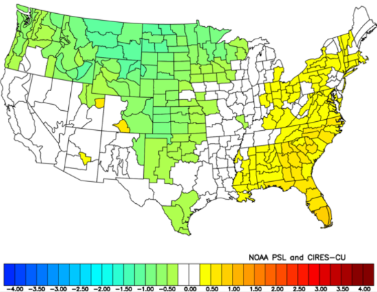
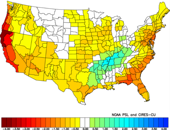
this is what i'm thinking for the winter pattern this year when looking at preliminary analogs. overall, I think we'll be looking at a winter with lots of ridging over the WC (or least nearby), likely pushing poleward into AK and north of Siberia, promoting -EPO and +PNA. this will displace the TPV SE at times, and although a SE ridge likely shows in the mean, it's likely suppressed for a decent portion of the winter Dec can feature some blocking, aided by the -QBO. I think the blocking certainly eases by Feb, but even then, the propensity for +PNA/-EPO should prevent a full on torch in the East. Jan is likely more +PNA driven, becoming warmer late in the month my main reasoning is that we're going to enter into a cool neutral ENSO state (weak Nina per RONI), and it's increasingly likely that the Nina influence will be more east-based, allowing for more ridging into the WC and AK rather than a flat ridge over the NPAC. we're also looking at high solar, a -QBO, and a -PDO overall, my top analogs are 2024-25, 2021-22, 2001-02, and 1989-90 (I don't think we'll see an AK vortex like 2001-02, but it scored well with ENSO, PDO, and solar). I think the best analog for this winter is last winter, as the ENSO, PDO, solar, and similarities to last summer's pattern are hard to ignore temps are slightly AN in the east with solidly BN precip (though it shouldn't be quite as dry as last winter)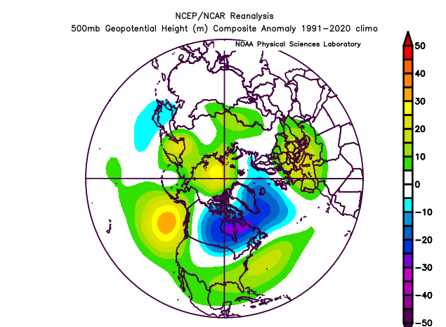
-
 Really pouring here now (SI) with some moderate flash flooding.
 -
Hurricane Erin: 110 MPH - 943 mb - N @ 13
BarryStantonGBP replied to BarryStantonGBP's topic in Tropical Headquarters
Were you in hurricane Georges in 1998 -
Marysville rain was .44 today.
-
Looking forward to the cooler temps. Just wish we could buy some rain. Everything is dying in this area.
-
Hurricane Erin: 110 MPH - 943 mb - N @ 13
Coach McGuirk replied to BarryStantonGBP's topic in Tropical Headquarters
Erin reminds me of hurricane Floyd in 1999 but out to sea. -
Come on now, it's the first rainy day in like forever.
-
A lot of churn from Erin here in EI, not much wind, water has reached the dunes. Humid as hell and winds direction bringing the flies in force. Need to be on the beach for the breeze to be strong enough to fight them off.
-
yes yes and more yes!!!
-
Ah yes, the ole .26 “wall of water”
-
57 and rain (at least it’s raining) Coc k!
-
Wow! The cold snap of '25 . Something to tell your grandchildren about. Was there some sort of volcanic eruption?