All Activity
- Past hour
-
Looks like a January winter day!
-
Ah yes. My favorite time of year. When it’s in the 70s in Quebec and the 50s on Long Island.
-
I think alot goes today it's already 39 here probably overperformer on warmth
-
Hrrr is interesting
-
No arguments here. We need some sunshine.
-

E PA/NJ/DE Spring 2026 Obs/Discussion
The Iceman replied to PhiEaglesfan712's topic in Philadelphia Region
I believe you said 70 by March 1st. It was in the 40's that day FYI. I'm skeptical we hit 70 even this weekend but we shall see, you may end up being right that it gets warmer in spring, gutsy call and all.. -

Pittsburgh/Western PA WINTER ‘25/‘26
RitualOfTheTrout replied to Burghblizz's topic in Upstate New York/Pennsylvania
I mean if you are expecting consecutive days of highs in the 20s and sustained snowpack yeah, not happening. I think the point is after the warm-up there is a window for a storm to coincide with the colder than average temperatures. All you need is it to be just cold enough and get a dynamic storm with heavy snow and it won't matter if the ground is warm, it was 70 the day before, or the sun angle. Is it likely? No. Is it my preferred type of Winter weather? No. However, any forecaster worth an ounce of salt would be remiss to at least not discuss the fact Winter may have one more trick up its sleeve before Spring really sets in. -
New chief met.
-
https://x.com/shirispear/status/2029154769319633053?s=46&t=dhcbvkjmRcyBVQtDxJ3lRg
-
We repent and pray for salvation
-
Good for you..enjoy. No school yesterday, and a delay today…didn’t expect this on Monday.
-
(002).thumb.png.6e3d9d46bca5fe41aab7a74871dd8af8.png)
Central PA Spring 2026 Discussion/Obs Thread
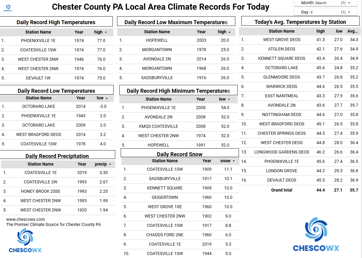
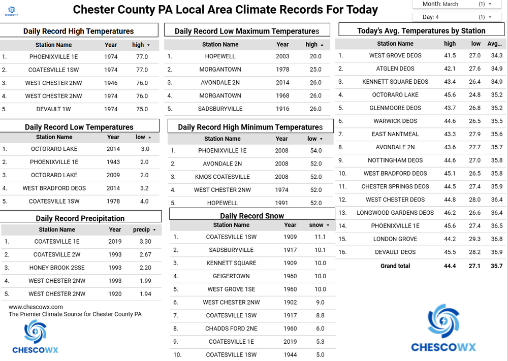
ChescoWx replied to Voyager's topic in Upstate New York/Pennsylvania
Unfortunately, our warmth will be a bit muted for the rest of the work week along with rain much of the time. Today will likely be our "warmest" day of the work week with highs in the upper 40's. The pain of spring in the Northeast with chilly ocean water temperatures will rear its ugly head for the rest of the week as winds back off the very chilly ocean and drive temps back down into the low to mid 40's at best for both Thursday and Friday. We finally warm up for the weekend with temps into the 60's. We should see as much as 0.75" to an inch of beneficial rains over the rest of the work week.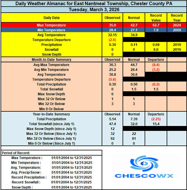
-
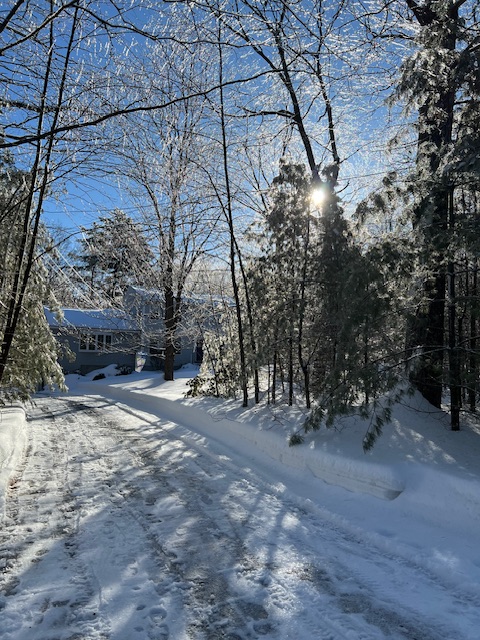
This morning while snowblowing the end of the driveway. All of the ice on the trees was dripping with the sun.
-
E PA/NJ/DE Spring 2026 Obs/Discussion
ChescoWx replied to PhiEaglesfan712's topic in Philadelphia Region
Unfortunately, our warmth will be a bit muted for the rest of the work week along with rain much of the time. Today will likely be our "warmest" day of the work week with highs in the upper 40's. The pain of spring in the Northeast with chilly ocean water temperatures will rear its ugly head for the rest of the week as winds back off the very chilly ocean and drive temps back down into the low to mid 40's at best for both Thursday and Friday. We finally warm up for the weekend with temps into the 60's. We should see as much as 0.75" to an inch of beneficial rains over the rest of the work week.
-

Central PA Spring 2026 Discussion/Obs Thread
anotherman replied to Voyager's topic in Upstate New York/Pennsylvania
-
Ole’ man winter letting us out with the seasonal change. A steady and subtle progression. Just keep ticking lines of latitude north on that northern jet with the ISR increasing and we’re good to welcome real spring earlier than in recent years.
-
KBOS is 4.3 on Bufkit
-
Lots of low ratio stuff in there. Very nuanced look.
-
3k and H cubed have ice
-

Central PA Spring 2026 Discussion/Obs Thread
mahantango#1 replied to Voyager's topic in Upstate New York/Pennsylvania
Indeed they can be very cruel to us. But better days of temps in the 90's and dp in the 70's aren't too far away! -

Winter 2025-26 Medium/Long Range Discussion
WestMichigan replied to michsnowfreak's topic in Lakes/Ohio Valley
As soon as I saw 0z gfs I knew this wasn't going to end well. -
You can almost see that decoupling on the cinema ... there's a sw moving subtle kink in the geometry of the isobars sliding down the coast behind that weak wave's exodus, like moving a like passing a dowel under a rug. That's a BD for the MA.
-
Great area, just not for snow
-
GFS is .67 freezing at BDL NAM is rain

-
Not quite a redux coming up next but some similarities. That looks like like a narrower snow production, possibly from Rt 2 N. Those areas in N CT up through the SW 'burbs of Boston probably don't fare so snow well. But they'll be cool and cooling off, so IP fest? Not a ton of either tho. The whole thing is moving really fast. There does appear to be a tiny 2 hour period of tuck potential.. It's interesting because as that shallow near surface slosh back is happening the total troposphere thicknesses are rising. Our regional topography can sometimes force the atmosphere to decouple, where the lower 150 mb may as well be a different planet