All Activity
- Past hour
-
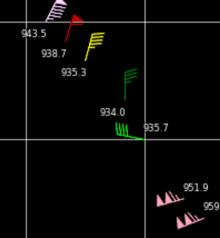
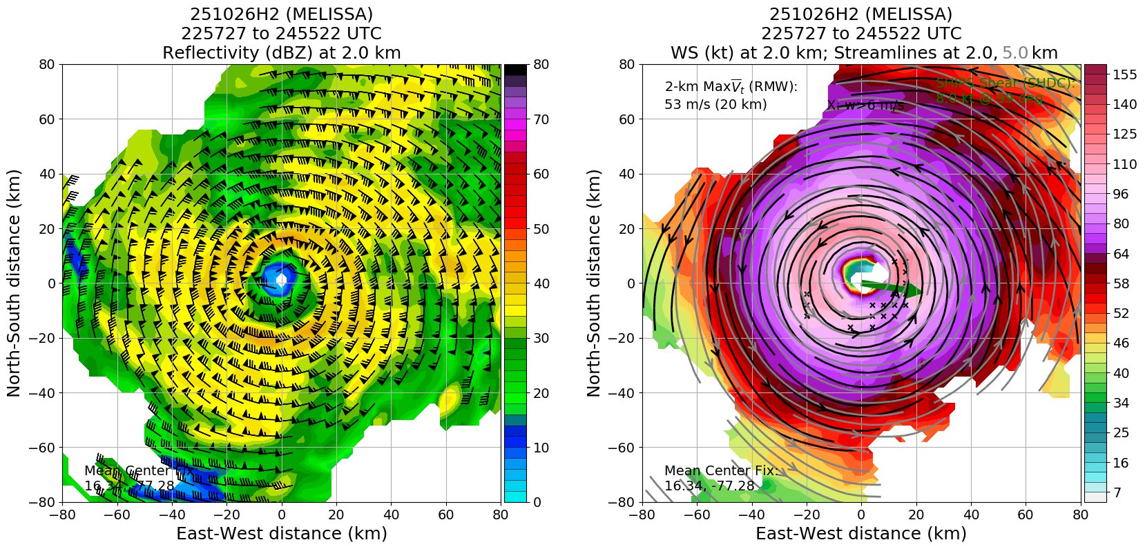
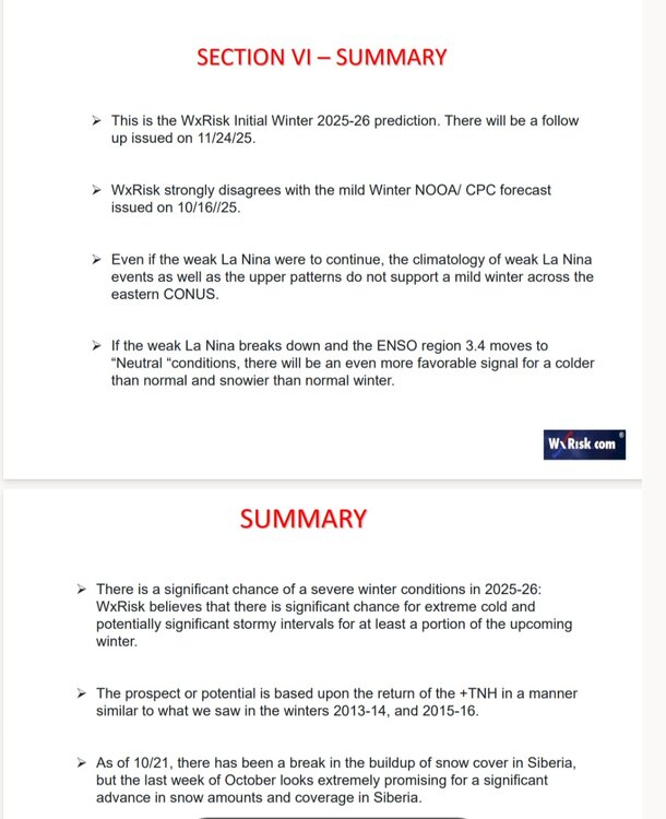
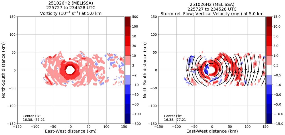
11:00 PM EDT Sun Oct 26 Location: 16.3°N 77.5°W Moving: W at 5 mph Min pressure: 933 mb Max sustained: 145 mph
-
This webcam over the hill in Island Park is pretty fun to watch. In the winter they set up a 7 foot tall ruler so you can see the snowdepth at any time. IP's longterm average is about 210" but lately (since 2000) they seem to be averaging more like 240". https://highmountainadventures.com/live-cam
-

-
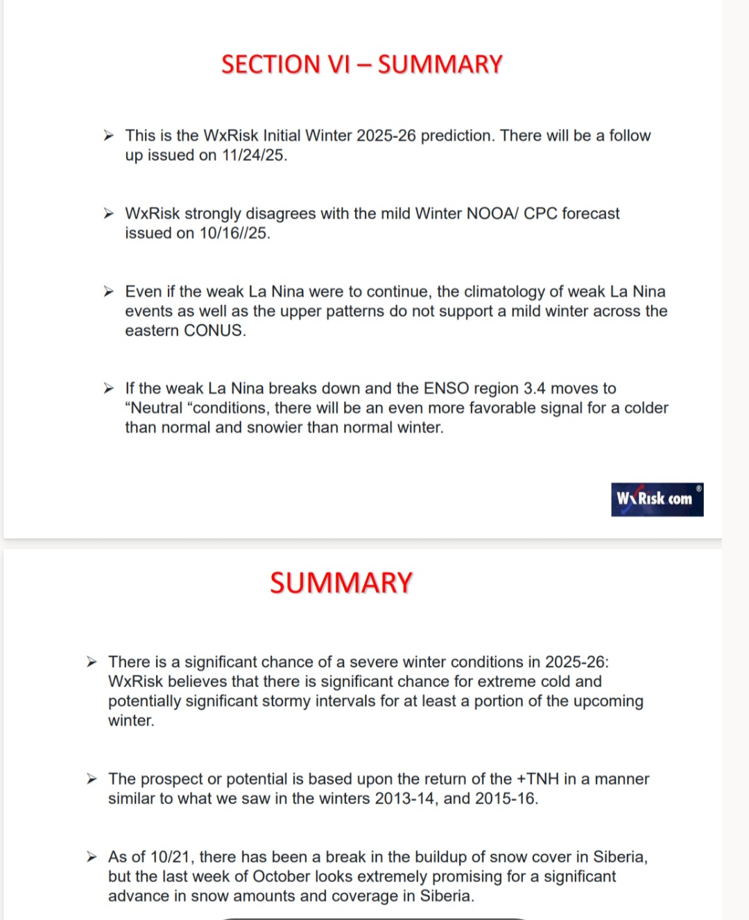
DT Preliminary Winter Outlook

-
DT Preliminary Winter Outlook
-
38 in Muttontown & 40 in Syosset.
-

Spooky Season (October Disco Thread)
mreaves replied to Prismshine Productions's topic in New England
I was cold playing golf at 1100’. We could see what looked like snow showers in the higher elevations of the Worcester Range. -
They look goofy lol
-
What a monster. Looks like it might do an ERC in the next 12 hrs or so. Not good, because then the wind field will expand further.
-

The return of the elusive Nor'easter. Drought buster or bust?
AlexD1990 replied to dailylurker's topic in Mid Atlantic
Cutting it a bit close for my liking, but I'll take some mixing paste if it means the whole sub gets plastered. Just give me some CCB on the backside as the low moves away after stalling for 3 days Sent from my Pixel 9 Pro XL using Tapatalk -
Pressure holding steady and no longer tanking. Looking at TDR, perhaps an outer eyewall trying to go up. Looks like an ERC or MERC about to commence soon.

-
Apparently hurricane hunters are struggling to hit the eye because it's small and turbulence. Hopefully they get a good sample before having to head back.
-
Yep. Was 39 now up to 39.8 with a breeze developing. Don’t see us going lower than 37
-
It looks as good as it ever has. Very cold cloud tops now rotating around core. I would be shocked if we didn't have a Cat 5 by morning.
-
Model consensus is sold on it moving NNE into western Jamaica. These wobbles aren't uncommon and will correct themselves.
-
38
- Today
-
That would be incredible.
-
I'm not far from the water, about a mile and a half. In November 2012 I had 8 inches of paste while LGA recorded 1 inch because of the station being right next to the East River.
-
It isn’t just upwelling that cools the waters at or near where a hurricane crosses: it also cools due to the conservation of energy (potential energy from warm water transitions to kinetic (wind) energy of the storm/heat engine), cooling from raindrops (I assume this factor is relatively minor), and cooling from cloudcover blocking the sun: Hurricanes cool the ocean by acting like "heat engines" that transfer heat from the ocean surface to the atmosphere through evaporation. Cooling is also caused by upwelling of cold water from below due to the suction effect of the low-pressure center of the storm. Additional cooling may come from cold water from raindrops that remain on the ocean surface for a time. Cloud cover may also play a role in cooling the ocean by shielding the ocean surface from direct sunlight before and slightly after the storm passage. All these effects can combine to produce a dramatic drop in sea surface temperature over a large area in just a few days. https://earthobservatory.nasa.gov/images/6223/passing-of-hurricanes-cools-entire-gulf#:~:text=Hurricanes cool the ocean by,pressure center of the storm
-
I'm really not seeing weakening. It's throwing up hot towers like crazy.
-
Is it me or does it look like it’s weakening just a hair?
-
Eventually the longer term pattern will change. It’s well known that the north shore is the place to be on LI during winter storms with the added moisture from the sound entraining into the synoptic scale precipitation bands. Now the pattern is more like that of 70s/80s with the coastal hugger storm tracks. I moved out to PA in 2005 and you guys probably got 3x more snow since then through 20/21 than what I saw here.
-
Dude, no offense and I enjoy some of your posts… this is the least surprising take I’ve ever seen on the board, and I’ve been on here or easternwx (or wright weather before that) for over twenty years.
-
I moved here in Nov 2018 thinking I’d finally cash in on good winters here vs growing up in Long Beach. Then the luck areawide ran out lol (other than 20-21).
-

Spooky Season (October Disco Thread)
powderfreak replied to Prismshine Productions's topic in New England
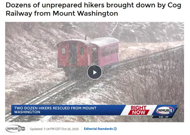
Sounded like a lot of people got in over their heads this weekend. I was cold on Mount Mansfield wandering around, but it’s only 4,000ft and I know I can get down rapidly on foot. MWN is 2,000 feet higher (10F usually). The tourists were still in autumn mode. I always travel prepared this time of year with the basics of change of base layer if get sweaty on the way up, plus gloves and hat this time of year. It’s crazy how much those things matter. You could be in shorts even (not ideal or recommended), but if your upper body core is warm with layers, head is warm, and hands covered… those are the keys to both comfort and survival.