All Activity
- Past hour
-
What is trenton? Philly has been running really high.
-
Depends on how we get to +4… we’ve had some luck recently with that because it never radiates all month and its like +5 because mins average 18F instead of 11F. We’ve had some whopper departures though recently that come out passable. BTV had measurable snowfall on 17 days in Jan 2023, 19.9” fell (average of 17.4”)… with a +8.3 departure . Every day was like 35/25 which is like +12.
-

Augdewst 2026: Summer's Last Stand
Damage In Tolland replied to Prismshine Productions's topic in New England
Heavy heavy drizzle moving daughter into Uconn apartment. Building has two elevators . Only one was working and then the 2nd broke with people stuck in it . 4th floor apartment .. drenched in sweat . Turned into a great day ! -

Augdewst 2026: Summer's Last Stand
Baroclinic Zone replied to Prismshine Productions's topic in New England
Stellar day in AEMATT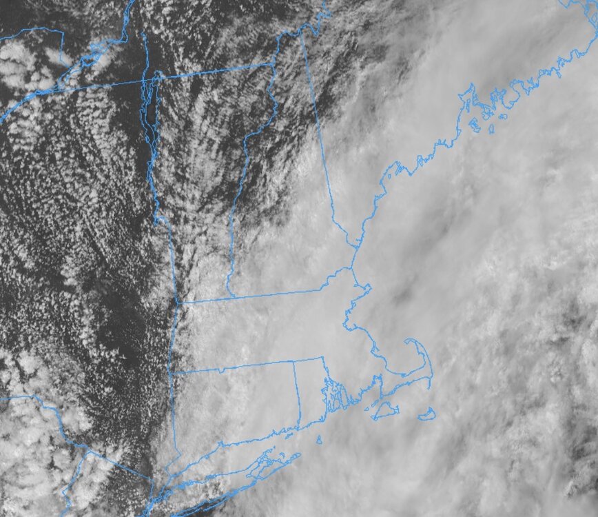
-

Augdewst 2026: Summer's Last Stand
VivaManchVegas replied to Prismshine Productions's topic in New England
Did you get that think bubble wrapped from Arizona? -

super el nino banter thread
LakePaste25 replied to forkyfork's topic in Weather Forecasting and Discussion
^ good place to grow Alfalfa while giving the farmers free water lmao -
1.11", sun coming out now
-
don't ask me why.....going tonight.
-
(002).thumb.png.6e3d9d46bca5fe41aab7a74871dd8af8.png)
E PA/NJ/DE Summer 2026 Obs/Discussion
ChescoWx replied to PhiEaglesfan712's topic in Philadelphia Region
If not for Philly maybe the how much for my backyard question LOL! -
Sweet ranger.
-

2026-2027 Record-breaking El Nino
GaWx replied to Stormchaserchuck1's topic in Weather Forecasting and Discussion
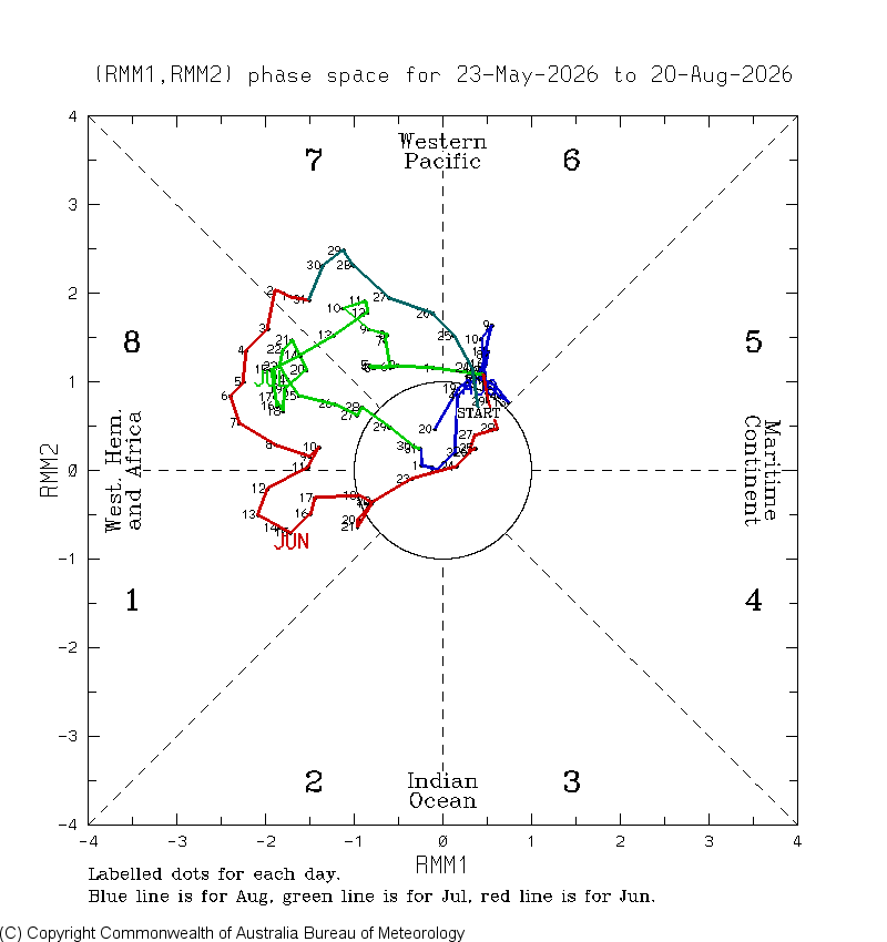
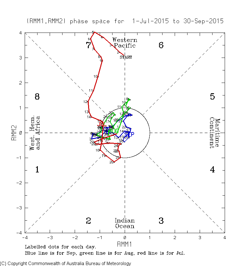
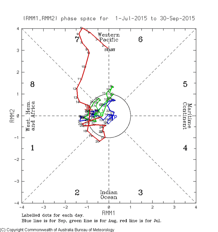
During the last 90 days, 86 of them were in MJO phases 6, 7, 8, or 1! The other 4 were only barely into phase 5 (inside circle) and since records started in 1974 there’s no instance of a 90 day period with >95% of the days in either the WPAC or the W Hem/Africa: The closest is 7/25/15-10/22/15, which had 81 of the 90 days (90%) in 6-7-8-1: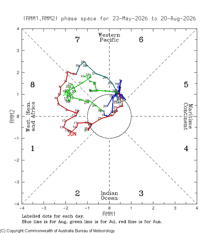
-

E PA/NJ/DE Summer 2026 Obs/Discussion
JTA66 replied to PhiEaglesfan712's topic in Philadelphia Region
Are you saying we may finally be able to answer the age-old question, “How much for Philly?” 78F/DP 66F Went to mow an area of the yard I only get to once a month or so. Wasn’t sure I’d be able to get to it, expecting muddy conditions. But despite all the rain this past week, the soil was just damp, no mud. -
And PHL +3.6
-
 [url=https://tajmeds.top/#]tajmeds[/url]
 - Today
-
overnight low of 59--the house is still nice and cool.
-
We’ve got a dog who likes to whizz on the grass rather than on bushes or our fence, so we’ve got those dead spots, as well. I plan to get at the lawn during the second or third weekend of September. It’ll be the first time I’ve really done anything to it in quite a few years, so we’ll see what happens.
-
I think we could easily go through the rest of August with <5 ACE points. Zero additional ACE points certainly in play but not ready to go that low just yet but certainly possible.
-
Viagra online price and sildenafil online viagra without prescription http://presto-pre.com/modules/wordpress/wp-ktai.php?view=redir&url=https://primemensrx.shop viagra without prescriptionand https://allchoicesmatter.org/user/frjadrfgjd/?um_action=edit order viagra [url=https://csgotraders.net/linkfilter/?url=https://primemensrx.shop]buy viagra here[/url] over the counter sildenafilor [url=http://georgiantheatre.ge/user/pecwdhjvcm/]buy Viagra over the counter[/url] Cheap generic Viagra
-

Augdewst 2026: Summer's Last Stand
powderfreak replied to Prismshine Productions's topic in New England
Love it… “Today is one of those chamber of commerce type days…” -

2026-2027 Record-breaking El Nino
michsnowfreak replied to Stormchaserchuck1's topic in Weather Forecasting and Discussion
Sept 1997 looks cooler than avg but nothing crazy. -
Central PA Summer 2026 Discussion/Obs Thread
ChescoWx replied to Voyager's topic in Upstate New York/Pennsylvania
-
Central PA Summer 2026 Discussion/Obs Thread
ChescoWx replied to Voyager's topic in Upstate New York/Pennsylvania
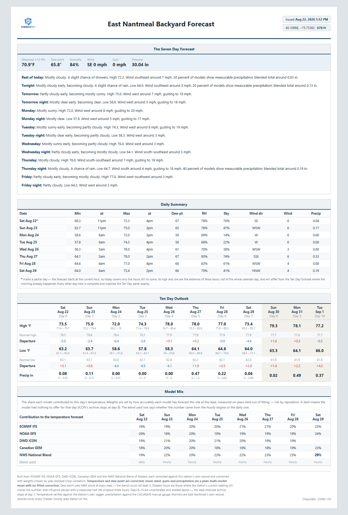
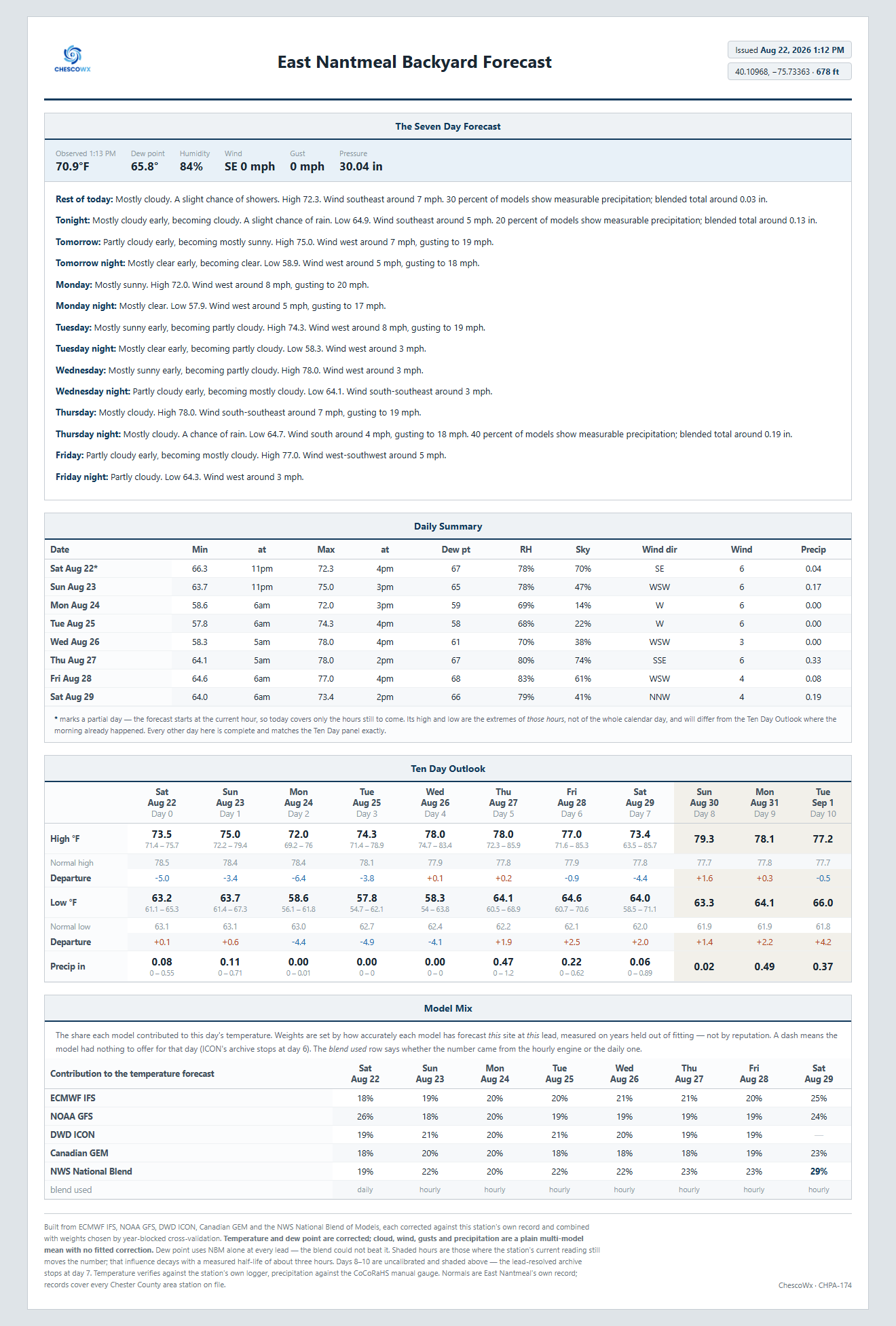
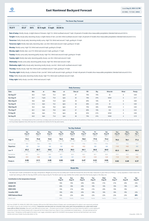
Some of you may remember I used a program called WXSIM to build my own "in my backyard" forecast. Well with AI and my own detailed weather station climate history at this location since 2004. I have developed a new hyper local backyard forecast. Below is the high level background on how it was built. I will also track this AI forecast vs. my NWS Point and Click forecast to see how accurate or not it actually turns out to be. How the East Nantmeal Backyard Forecast Is Built A ten-day forecast for one hilltop in northern Chester County, trained on that hilltop’s own twenty-two year record — and measured against the National Weather Service’s own guidance on days it had never seen. 40.10968°N, 75.73363°W · 677.7 ft USGS 3DEP Davis Vantage Pro 2, fan-aspirated, in service since 2004 CoCoRaHS · NWS Skywarn CHPA-174 The short version Five weather models are pulled for this exact coordinate — the European ECMWF, NOAA’s GFS, the German DWD ICON, the Canadian GEM, and the National Weather Service’s own National Blend of Models. Each one is corrected using its own track record at this East Nantmeal site — how wrong it has been here, in this month, at this hour of the day, at this many days out. The corrected forecasts are then combined, weighted by how much each has earned. Finally the whole trace is nudged toward what the station is reading right now, by an amount that decays as the present stops mattering. Nothing in it is a physical simulation. It does not model soil moisture or cold-air drainage from first principles. It measures what those things have actually done to this thermometer, over years, and applies that. The site Everything rests on one sensor. A Davis Vantage Pro 2 with a solar fan-aspirated shield, five feet above ground over grass, in service since 2004. The anemometer is roof-mounted, and reads well below open exposure because hills rise in every direction. Corroboration: the station behaves like its elevation and is accurate A forecast trained on one sensor invites an obvious question — is that sensor telling a coherent story, or just producing numbers? One way to test it is to compare against a research-grade station nearby and ask whether the difference between them looks like physics. Avondale 2N is a U.S. Climate Reference Network site about nineteen miles south, at 409 ft — 268 ft below East Nantmeal. USCRN stations use triple-redundant sensors and are built for exactly this kind of reference use. The two records overlap for 7,139 days, from January 2007 to August 2026. East Nantmeal minus Avondale 2N, 7,139 overlapping days, 268.5 ft apart. The two stations track each other almost perfectly day to day — r = 0.996 on highs and 0.988 on lows across nearly twenty years. And the offset between them is exactly the shape elevation predicts: the higher site runs cooler by day and warmer by night, giving East Nantmeal the narrower diurnal range. Cool days come from elevation; mild nights come from cold air draining off a hilltop into the valleys instead of pooling on it. Expressed as a lapse rate, that is −5.08 °F per 1,000 ft on highs and +5.23 on lows. Earlier work in this archive, using an entirely different station pair — Phoenixville 1E, some 550 ft lower — and a different era, arrived at −5.23 and +4.85. Two independent comparisons landing within a few tenths of each other! I will post the latest forecast below. Let me know if any questions or suggestions. Thanks! -
E PA/NJ/DE Summer 2026 Obs/Discussion
ChescoWx replied to PhiEaglesfan712's topic in Philadelphia Region
-
E PA/NJ/DE Summer 2026 Obs/Discussion
ChescoWx replied to PhiEaglesfan712's topic in Philadelphia Region
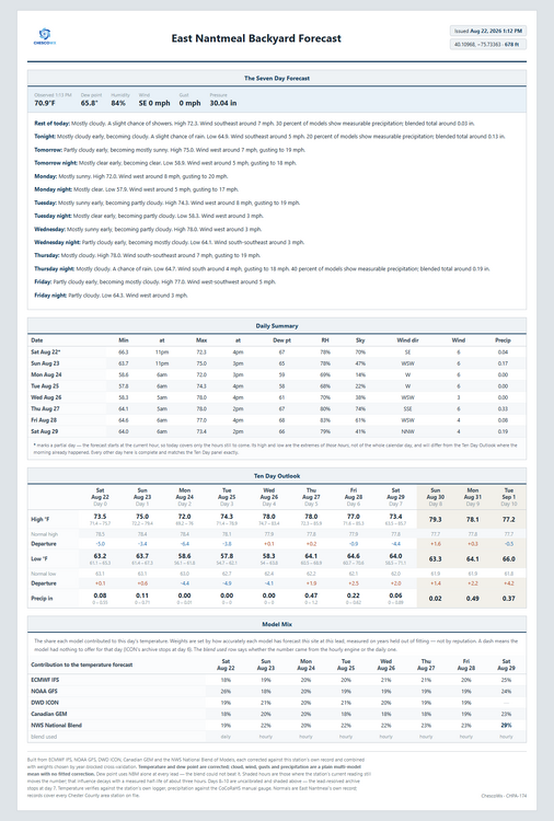
Some of you may remember I used a program called WXSIM to build my own "in my backyard" forecast. Well with AI and my own detailed weather station climate history at this location since 2004. I have developed a new hyper local backyard forecast. Below is the high level background on how it was built. I will also track this AI forecast vs. my NWS Point and Click forecast to see how accurate or not it actually turns out to be. How the East Nantmeal Backyard Forecast Is Built A ten-day forecast for one hilltop in northern Chester County, trained on that hilltop’s own twenty-two year record — and measured against the National Weather Service’s own guidance on days it had never seen. 40.10968°N, 75.73363°W · 677.7 ft USGS 3DEP Davis Vantage Pro 2, fan-aspirated, in service since 2004 CoCoRaHS · NWS Skywarn CHPA-174 The short version Five weather models are pulled for this exact coordinate — the European ECMWF, NOAA’s GFS, the German DWD ICON, the Canadian GEM, and the National Weather Service’s own National Blend of Models. Each one is corrected using its own track record at this East Nantmeal site — how wrong it has been here, in this month, at this hour of the day, at this many days out. The corrected forecasts are then combined, weighted by how much each has earned. Finally the whole trace is nudged toward what the station is reading right now, by an amount that decays as the present stops mattering. Nothing in it is a physical simulation. It does not model soil moisture or cold-air drainage from first principles. It measures what those things have actually done to this thermometer, over years, and applies that. The site Everything rests on one sensor. A Davis Vantage Pro 2 with a solar fan-aspirated shield, five feet above ground over grass, in service since 2004. The anemometer is roof-mounted, and reads well below open exposure because hills rise in every direction. Corroboration: the station behaves like its elevation and is accurate A forecast trained on one sensor invites an obvious question — is that sensor telling a coherent story, or just producing numbers? One way to test it is to compare against a research-grade station nearby and ask whether the difference between them looks like physics. Avondale 2N is a U.S. Climate Reference Network site about nineteen miles south, at 409 ft — 268 ft below East Nantmeal. USCRN stations use triple-redundant sensors and are built for exactly this kind of reference use. The two records overlap for 7,139 days, from January 2007 to August 2026. East Nantmeal minus Avondale 2N, 7,139 overlapping days, 268.5 ft apart. The two stations track each other almost perfectly day to day — r = 0.996 on highs and 0.988 on lows across nearly twenty years. And the offset between them is exactly the shape elevation predicts: the higher site runs cooler by day and warmer by night, giving East Nantmeal the narrower diurnal range. Cool days come from elevation; mild nights come from cold air draining off a hilltop into the valleys instead of pooling on it. Expressed as a lapse rate, that is −5.08 °F per 1,000 ft on highs and +5.23 on lows. Earlier work in this archive, using an entirely different station pair — Phoenixville 1E, some 550 ft lower — and a different era, arrived at −5.23 and +4.85. Two independent comparisons landing within a few tenths of each other! I will post the latest forecast below. Let me know if any questions or suggestions. Thanks! -
Finished with 0.24” which brings MTD to 1.36”