All Activity
- Past hour
-
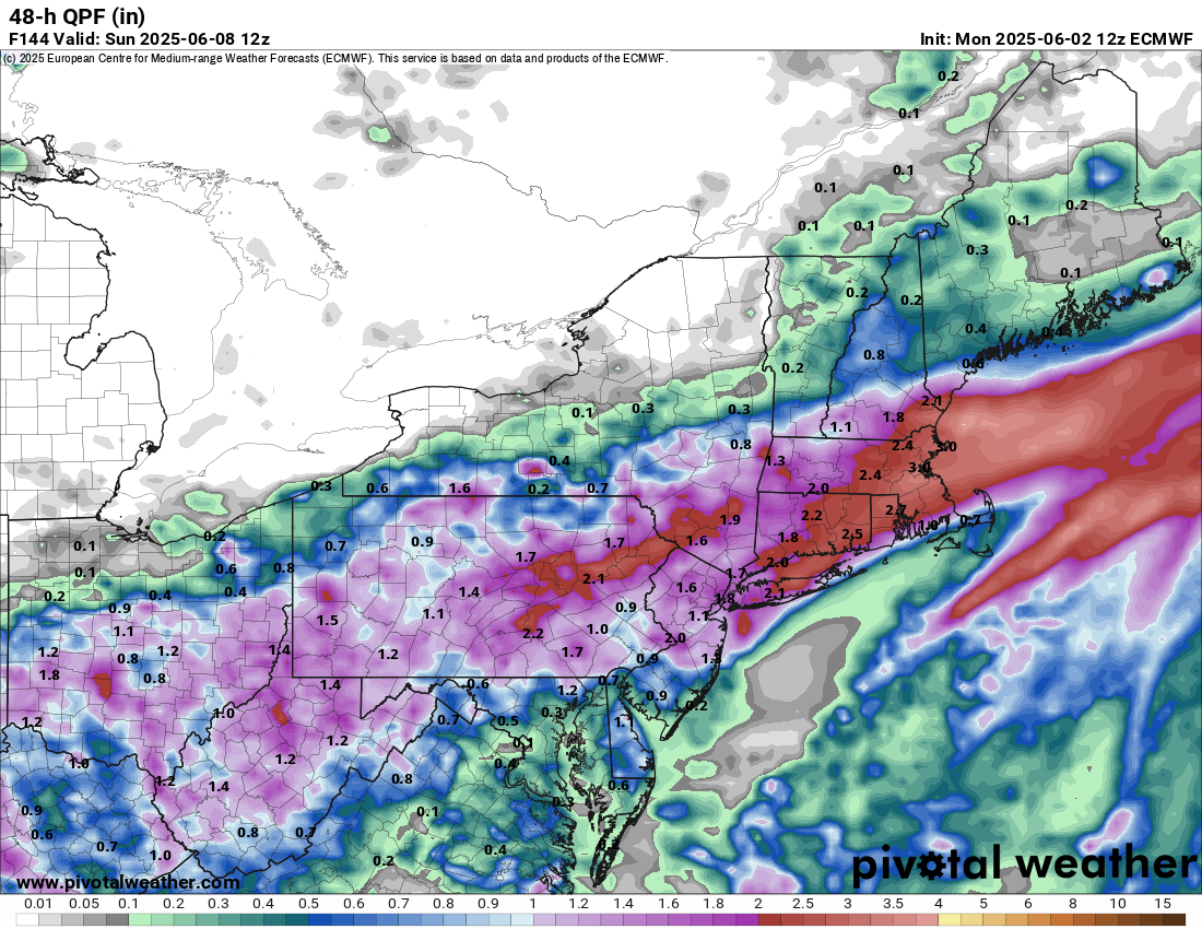
Been watching a possible area off the SE coast in the next few days and NHC has a lemon for it now. Low chance but if it stay offshore it could become a weak low.
-
Popped off our 2nd 90 temp of 2025 today, at least dews are manageable in the mid 50s. Big dog ground smoke heading this way. The Fargo area has had an AQI over 250 today. Letting the kids enjoy the splash pad before we are locked indoors.
-

2025-2026 ENSO
michsnowfreak replied to 40/70 Benchmark's topic in Weather Forecasting and Discussion
Good point in bold. There are winters where we both have done well, BUT when you examine even those winters, you will notice its different parts of the winter that stand out for each of us. -
Yeah not a crazy setup for widespread severe but we would certainly see some localized severe weather each day I'd think.
-
Would be the icing on the cake if everyone has to stay inside for another Saturday, but this time without power.
-

2025 Atlantic Hurricane Season
Roger Smith replied to BarryStantonGBP's topic in Tropical Headquarters
Enter your forecast for seasonal totals of storms, hurricanes, and major hurricanes (in the North Atlantic basin) ... using NOAA official counts as our contest guide ... separate thread in tropical forum. -
CSU April 3, 2025 17 9 4 UKMO May 21, 2025 16 9 4 NOAA __ May 22, 2025 13-19 6-10 3-5 (16 8 4 avg fcst)
-
Guess it depends on instability, but setup didn't appear that way to me. There would be some verbatim.
-
let's get after it! May as well root for big 'un totals
-

2025 Atlantic Hurricane Season
Normandy Ho replied to BarryStantonGBP's topic in Tropical Headquarters
life’s already giving us lemons how about that bruh -
I was referring to highly unlikely possibility that so many of the hurricanes in both basins will become majors.
-

E PA/NJ/DE Summer 2025 Obs/Discussion
snowwors2 replied to Hurricane Agnes's topic in Philadelphia Region
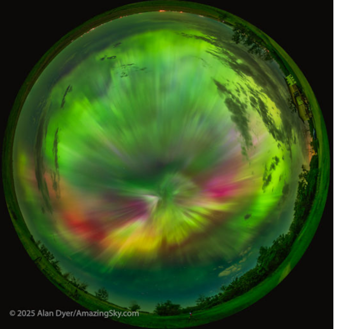
Might have missed here but not in Alberta… Check out this amazing skyward 360° panoramic (apparently SO bright that the entire ground looked green)‼️
-
how about if it's training severe ... nickle hail 3 times with incredible rain rates and overlapping multi-pulser CG bombs ...otherwise still 76/72-like
-
We want pretty much diametrically opposite patterns in the winter, although we have some like 2010-11 where we both do well. I think the final snow number comes from the fact that here, we usually get all or nothing type seasons and big individual storms rather than smaller nickel and dimes that can still get to 40+ inches on the season. And sustained cold is quite rare at least the last 10-15 years. Generally you want more of these Nina type setups since they favor the Lakes while I desperately want it to become more El Niño like. Whatever can make this wretchedness since Jan 2022 end I’m all for.
- Today
-
surprised it managed 80 considering it's been p milky skied all day
-
It's not good. Man these shit Saturday's absolutely suck the life out of the weekends. Hopefully it goes back north or gets more progressive.
-
Seems like convection and dews.
-
I'd prefer that too. The graduation party for my niece looks bad as of now.
-
I finished May with 7” of rain that’s the 6th time in last 60 years I have recorded that amount or more The others since 1965 are 1989,2003, 2008(record of 10.2”) 2009 and 2018
-
it's cloudy and rainy..not great
-
Appears to be wafting this way https://www.star.nesdis.noaa.gov/GOES/sector_band.php?sat=G19§or=cgl&band=GEOCOLOR&length=24
-
Storms with front across region?
-
Smoke is definitely starting to blow into the area up high. Was all blue here wall-to-wall in the morning but now the Western sky is definitely milky gray, east more blue.