All Activity
- Past hour
-

2025-2026 ENSO
40/70 Benchmark replied to 40/70 Benchmark's topic in Weather Forecasting and Discussion
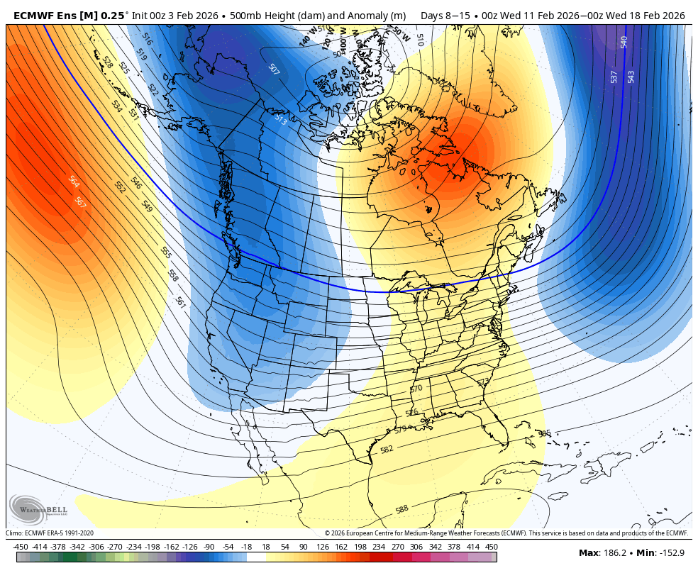
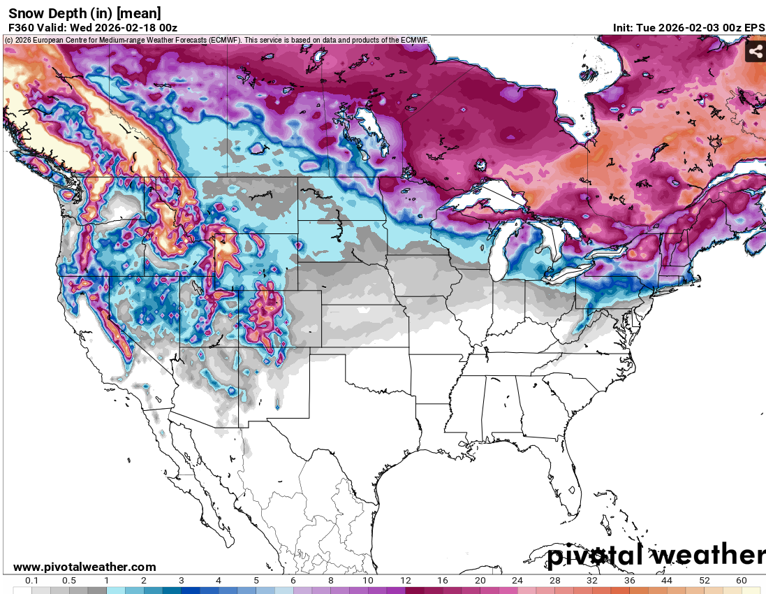
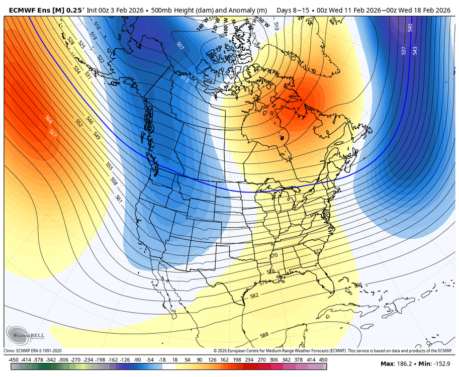
This is what I had for February in my Outlook last fall....I think there is still some colder risk to this forecast, but probably not as much as looked last week. February 2026 Outlook February Analogs: 2025, 2022, 2018, 2014,2008, 2002, 2001, 1971 The Alaskan ridge will rule this month, along with -PNA and +NAO. Some -NAO blocking could develop late if stratospheric warming gets underway early enough, but it likely holds off. Alaskan Ridge Regime Courtesy Lee et al (2019) The polar vortex should begin the month fairly strong, but will be weakening rapidly, as a SSW is likely by mid-month. The January-February 2001 transition from reflection event to SSW may be a reasonable expectation, in terms of progression, as RNA pattern resumes and refocuses the cold west prior to any SSW. The interior will continue to be favored for snowfall as the storm track remains either inland or hugs the coast. While not prohibitively warm, this will largely canonical La Niña month with average to below average snowfall on the coastal plane, and average to above average snowfall across the interior. Should the SSW develop in the earlier portion of the 1/17 to 2/17 window, the the second half of the month may change that due to the development of high latitude blocking, however, it is more likely not to occur until mid-month, as previously alluded to. The month will finish between +1F and +3F over New England and +2F to +4F over the mid Atlantic. -
Yeah, this has been the first time since 17-18 and 10-11 that Islip averaged under 35.0° for both December and January. Monthly Mean Avg Temperature for ISLIP-LI MACARTHUR AP, NY Click column heading to sort ascending, click again to sort descending. 2025-2026 34.3 29.6 32.0 2024-2025 36.5 30.4 33.5 2023-2024 42.2 35.1 38.7 2022-2023 36.8 41.1 39.0 2021-2022 41.7 28.8 35.3 2020-2021 37.2 32.9 35.1 2019-2020 36.8 37.3 37.1 2018-2019 38.1 31.1 34.6 2017-2018 33.8 30.1 32.0 2016-2017 36.6 36.2 36.4 2015-2016 48.4 33.3 40.8 2014-2015 39.6 28.7 34.2 2013-2014 37.1 27.7 32.4 2012-2013 40.5 33.1 36.8 2011-2012 40.5 36.2 38.4 2010-2011 31.5 27.1 29.3 2009-2010 34.5 30.4 32.5 2008-2009 36.7 26.5 31.6 2007-2008 35.1 33.8 34.5 2006-2007 41.1 35.9 38.5 2005-2006 33.5 37.5 35.5 2004-2005 35.2 28.5 31.9 2003-2004 36.6 23.5 30.1 2002-2003 33.5 26.5 30.0 2001-2002 41.2 37.7 39.5 2000-2001 29.6 29.5 29.6 1999-2000 38.3 29.5 33.9 1998-1999 40.0 33.7 36.9 1997-1998 37.7 39.1 38.4 1996-1997 39.0 30.2 34.6 1995-1996 31.4 30.4 30.9 1994-1995 39.7 38.0 38.9 1993-1994 35.2 25.6 30.4 1992-1993 36.1 34.6 35.4 1991-1992 37.3 32.5 34.9 1990-1991 39.9 32.1 36.0 1989-1990 24.8 37.9 31.4 1988-1989 33.4 34.6 34.0 1987-1988 36.8 26.6 31.7 1986-1987 36.4 30.5 33.5 1985-1986 32.1 31.7 31.9 1984-1985 41.2 26.2 33.7 1983-1984 33.6 27.3 30.5 1982-1983 40.1 32.7 36.4 1981-1982 36.1 25.8 31.0 1980-1981 33.5 25.2 29.4 1979-1980 39.1 32.3 35.7 1978-1979 36.9 31.7 34.3 1977-1978 32.8 25.5 29.2 1976-1977 28.9 20.8 24.9 1975-1976 35.2 26.5 30.9 1974-1975 36.9 35.0 36.0 1973-1974 38.4 32.8 35.6 1972-1973 39.6 32.7 36.2 1971-1972 40.1 33.7 36.9 1970-1971 34.0 27.1 30.6 1969-1970 33.4 23.3 28.4 1968-1969 29.3 30.1 29.7 1967-1968 33.1 23.8 28.5 1966-1967 33.0 33.8 33.4 1965-1966 36.0 29.5 32.8 1964-1965 35.5 25.5 30.5 1963-1964 28.1 32.3 30.2
-
Bring it. Sick of the cold. Ok, now flame me.
-
Robots like the 11-12 threat…
-

Pittsburgh/Western PA WINTER ‘25/‘26
RitualOfTheTrout replied to Burghblizz's topic in Upstate New York/Pennsylvania
Clipper still looking solid for Friday. 1-3 inches if I had to guess now. Those wanting a warmup, looks like after this arctic hit this weekend things will moderate. Looks a bit more active too, but rain and storms cutting west will be back on the table. -
It looks mostly cloudy and 22 degrees. Hopefully clouds hold temps down today.
-
Looks a lot more active next week and noticing confluence playing a role and keeping storms from cutting. So maybe a lot of redevelopers and SWFEs.
-
Yeah, I don’t know, it still looks like we moderate. It’s gonna be kind of a thread the needle I think to get snow events.
-
Low of 8F
-
Low is almost too far south lol
-
GFS as well. The extended looks primed up. February will be a tracking fun time.
-

February 2026 Medium/ Long Range Discussion: Buckle Up!
Ji replied to Weather Will's topic in Mid Atlantic
6z grok -
2025-2026 ENSO
40/70 Benchmark replied to 40/70 Benchmark's topic in Weather Forecasting and Discussion
Not sure where you are from, but late December and early January didn't warm up in the east, it was mid January. As far as the PNA, yes...I don't think I recall literally anyone going with a +PNA for the month of February. -
Could
-
I just couldn’t care less about cold. I’d like the snow:
-
There’s no traction in clown range. Wait until early next week.
-
Always impressive seeing the Great South Bay almost totally frozen over. The Long Beach Super Bowl splash has been postponed to March. I don’t remember that ever happening before. We did it in 2011 when there was still a lot of snow around from the 1/27 storm.
-
I feel like Friday night is about 10% more exciting now, it’s def trending south which should get more qpf albeit meager and more impactful cold .
-
2025-2026 ENSO
40/70 Benchmark replied to 40/70 Benchmark's topic in Weather Forecasting and Discussion
You do realize there is an imminent SSW at just about the same, exact time as 2018, right? You favor a warm start to March based on generic ENSO climo, then list three seasons that deviated from said expectation, which are quality overall analogs (2018, 2014) and a pretty good TNH analog (2015). -
Trough axis is simply not going to work even with the blocking outside of maybe NNE. Bring that trough further west, we can get systems dropping down from the NW. Or bring it east and we can get overrunning events W to E. But with this position, storms will cut.
-

Winter 2025-26 Medium/Long Range Discussion
A-L-E-K replied to michsnowfreak's topic in Lakes/Ohio Valley
march will be rocking?
-

February 2026 Medium/ Long Range Discussion: Buckle Up!
Chris78 replied to Weather Will's topic in Mid Atlantic
It's close to a big storm for us PD weekend. Maybe we need just enough cold not Vodka cold lol. -
 Fuk this. 1F
 -
 Down to 3F here Got into the mid 30s here yesterday for about 2 hours, warm enough to wash my car
 -
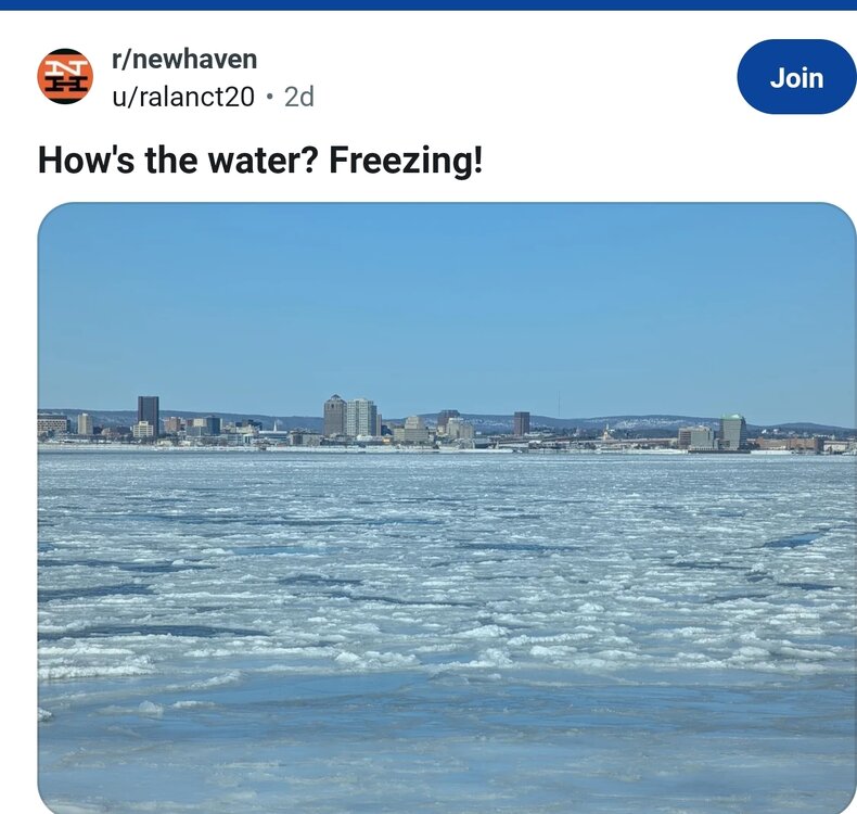
 New Haven Harbor has a ton of ice. I think 2012/2013 was the last time it happened. There are stories that in the winter of 1934 they drove cars and trucks across the ice was so thick.