All Activity
- Past hour
-

Occasional Thoughts on Climate Change
WolfStock1 replied to donsutherland1's topic in Climate Change
You keep shifting around the goalposts, even in your own posts. What kind of "death" are you talking about here? Because each type is hugely different. When you're talking about "world destiny" (your original) words, are you talking about: Death of humanity? Death of a bunch of non-human species? Death of "the world" - encompassing all of the above (a literal wasteland)? Each of these is *massively* different in their proposed causes, timeframes, scales, etc. Your term "world destiny" certainly sounds like the first or the latter, not just the death of a few species. While there are certainly a lot of species dying off in recent years - it has very much *not* been due to global warming; it's generally been due to habitat removal; in particular things like overfishing and overhunting (generally under control now), and forest clearing due to harvesting, farming, and development (still ongoing; though improving somewhat). On the latter - it's worth noting the massive acreage of forests that will be need to be cleared (or not allowed to regrow) to meet solar farm proposals; e.g. the 277,000-acre proposal in VA. If you're talking death of humanity - I refer to my previous chart, among other hopefully obvious things. The use of fossil fuels very much *lessens* the level of human deaths, in many, many ways. If things like king tides in Miami are such a big danger - wouldn't one expect the number of annual deaths from natural disasters to be steadily rising - not falling? Why aren't we seeing news reports of all these deaths being caused by these king tides? That seems... mysterious. -

2026-2027 Record-breaking El Nino
bluewave replied to Stormchaserchuck1's topic in Weather Forecasting and Discussion
With the historic +30C warm pool pushed so far to the east, we are just going to have to wait and see what effects the western extent of the +30C warm pool are relative to the eastern side. Plus the pattern since May has been the seasonal models underestimating the southward extent of the ridging across the CONUS. So it’s possible the typical super El Niño ridge position south of Hudson Bay gets shifted further south than usual. The ridge wound up further south than the 2023-2024 seasonal winter forecasts and that was a much weaker event than this one. This stronger mid-latitude ridge has been leading to the persistent -PDO +AMO pattern during the 2020s. -
 online drug or buy online medicine order medicines from india to usa https://www.google.mw/url?q=https://indigetrx.com indian pharma online pharmacy and http://sotoycasal.com/user/vasgpweqfc/ generic prescription drugs in india [url=https://maps.google.gg/url?q=http://indigetrx.com]indian pharmacies that ship to usa[/url] online medicine sites and [url=http://nosugar.co.uk/profile.php?uid=270652]india pharmacy online[/url] prescription drugs from india
 -
online drug or buy online medicine order medicines from india to usa https://www.google.mw/url?q=https://indigetrx.com indian pharma online pharmacy and http://sotoycasal.com/user/vasgpweqfc/ generic prescription drugs in india [url=https://maps.google.gg/url?q=http://indigetrx.com]indian pharmacies that ship to usa[/url] online medicine sites and [url=http://nosugar.co.uk/profile.php?uid=270652]india pharmacy online[/url] prescription drugs from india
-
High around 50 with rain today. Bring it, we need it.
-
safe canadian pharmacy: Can Get Rx - canadian pharmacy online
-
October 15 1968: Unseasonably warm weather moves into central and southern Minnesota. The high was 85 in the Twin Cities. 1899: Heavy rain falls, with 3.2 inches in the St. Cloud area and 2.1 inches in Willmar. For Thursday, October 15, 2026 1880 - A violent early season blizzard raked Minnesota and the Dakotas. Winds gusted to 70 mph at Yankton SD, and snow drifts 10 to 15 feet high were reported in northwest Iowa and southeast South Dakota. Saint Paul MN reported a barometric pressure of 28.65 inches on the 16th. Railroads were blocked by drifts of snow which remained throughout the severe winter to follow. Gales did extensive damage to ship on the Great Lakes. (15th-16th) (David Ludlum) (The Weather Channel) 1954 - Hurricane Hazel struck the Carolina coastline. The hurricane demolished every pier along a 170 mile stretch from Myrtle Beach SC to Cedar Island NC, and obliterated entire lines of beach homes. Hurricane Hazel also destroyed 1500 homes as it moved inland with seventeen foot tides. Winds between Myrtle Beach SC and Cape Fear NC gusted to 150 mph. Hurricane Hazel caused 163 million dollars damage, and claimed the lives of 98 persons. (David Ludlum) (The Weather Channel) 1966 - Iowa experienced its worst late season tornado of record. In just one minute a twister tore through the town of Belmond leveling 75 percent of the businesses, and 100 homes, causing more than eleven million dollars damage. (The Weather Channel) 1987 - Unseasonably cold weather continued in the eastern U.S., with thirteen cities reporting record low temperatures for the date. The low of 34 degrees at Montgomery AL was their coldest reading of record for so early in the season. Lows of 32 degrees at Harrisburg PA and 34 degrees at Parkersburg WV marked their third straight morning of record cold. (The National Weather Summary) 1988 - The cold high pressure system responsible for the record low temperatures in the eastern U.S. began to move out to sea, giving way to a trend toward "Indian Summer". Thunderstorms developing ahead of a cold front produced golf ball size hail at Altamont KS and hail two inches in diameter at Yates City IL. (Storm Data) (The National Weather Summary) 1989 - Hurricane Jerry made landfall at Galveston, TX, at 6 30 PM (CDT). Winds at the Galveston Airport reached 75 mph, with gusts to 100 mph. Tides along the island were six to eight feet, and rainfall totals ranged up to slightly more than six inches north of Beaumont. Three persons were killed when their vehicle was blown off the Galveston seawall into the pounding surf. Total damage along the Upper Texas Coast was estimated at fifteen million dollars. Thunderstorms produced severe weather in Lower Michigan during the late morning. Two persons were injured when a tree fell on their camper at the Traverse City State park. While strong northerly winds ushered much colder air into the central U.S., unseasonably warm weather continued in the south central and eastern U.S. The afternoon high of 82 degrees at Bluefield WV was a record for October. (The National Weather Summary) (Storm Data) Observances: 15 Thu White Cane Safety Day 15 Thu National Grouch Day 15 Thu Global Handwashing Day 15 Thu National Mushroom Day 15 Thu International Day of Rural Women 15 Thu National Cheese Curd Day 15 Thu National Expense Report Day 15 Thu National Esthetician Day 15 Thu National Latino AIDS Awareness Day 15 Thu National Lemon Bar Day 15 Thu Pregnancy and Infant Loss Remembrance Day 15 Thu World Students’ Day 15 Thu HSA Day 15 Thu I Love Lucy Day
-

2026-2027 Record-breaking El Nino
40/70 Benchmark replied to Stormchaserchuck1's topic in Weather Forecasting and Discussion
You would think that would be reflected in the precip output, but perhaps the models are just in error in that regard. We shall find out. BTW, I think the break did you well....your approach to disagreement is noticeably different and great for discussion. -
2026-2027 Record-breaking El Nino
40/70 Benchmark replied to Stormchaserchuck1's topic in Weather Forecasting and Discussion
Yes, but you are neglecting the western portion of that "birdge", which actually has the heaviest precipitation anomaly...this is why I argue for increased variability relative to the super composite. -
Know it well….cute lil town off Rt 161.
-

2026-2027 Record-breaking El Nino
snowman19 replied to Stormchaserchuck1's topic in Weather Forecasting and Discussion
Just a friendly disagreement, I think the forcing is actually going to end up to the east of the super El Niño composites because of the anomalously (record) east 30C warm pool. It is going to alter the global heat budget and shift the main forcing IMO -
Enjoy your 300" of fluff.
-
2026-2027 Record-breaking El Nino
bluewave replied to Stormchaserchuck1's topic in Weather Forecasting and Discussion
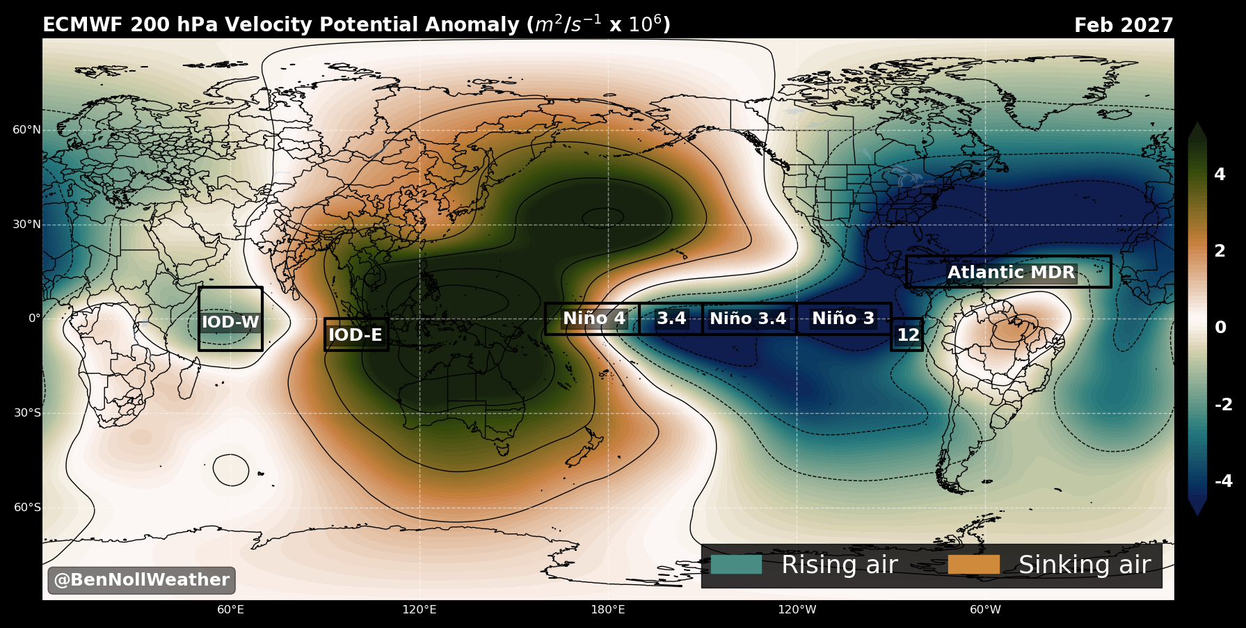
I don’t think we were discussing the same exact parameters. The Nino 3 Euro forecast is nearly identical to the JMA keeping the Nino 3 anomalies over +4 into late January or February. The Nino 1+2 forecasts for both the JMA and Euro are similar. The reason I posted the JMA is that the Euro doesn’t have an absolute forecast on their site only the anomalies. So we have to work out the Euro absolutes manually. So even if the actual Nino 1+2 absolutes top out at say 29.5 C, there will likely be +30C actual SSTs just to the north near Central America or even near southern Mexico. You can see the forcing bridge on the Euro developing linking Nino 3.4 all the way over to Central America. This is signaling how far east the +30C warm pool is going to be similar to the JMA and Euro absolutes.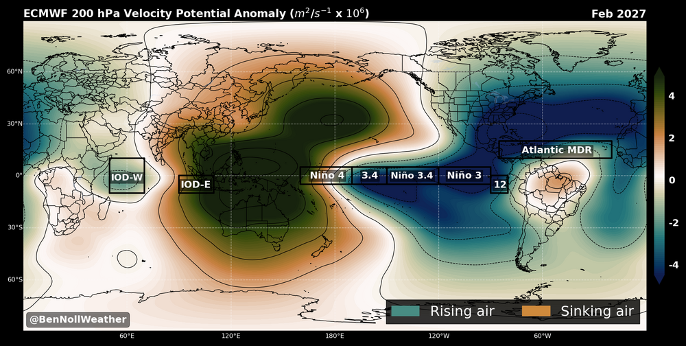
-
So the wet pattern got can kicked again…
-
New Sweden (just north from CAR) reported 1.0".
-
DT was comparing it to the perfect storm on FB.
-
many people don't believe this is an existential crisis for long term human civilization because so far, many people have been able to adapt to the changes that they have experienced, so far it has already become an existential crisis for some people living in and around Miami as king tides increasingly impact low lying neighborhoods; people can't sell their homes because the value is greatly diminished due the reoccurring sunny day flooding, which is progressively getting worse. for a person who lives in such a neighborhood and needs to sell and leave, it IS an existential crisis. same goes for millions who live on only feet above sea level in southeast Asia, which have substantially less means that the home owner getting flooded out in southern Florida has we've been discussing AGW/climate change and it's on-going effects since the 1970s. it's well understood. because the facts and basis for it are so widely accepted, there is a general frustration with people who won't accept the facts, or modify their behaviors accordingly
-

E PA/NJ/DE Autumn 2026 Obs/Discussion
JTA66 replied to PhiEaglesfan712's topic in Philadelphia Region
Slight risk day 2 west of the river. We'll see. -
2026-2027 Record-breaking El Nino
40/70 Benchmark replied to Stormchaserchuck1's topic in Weather Forecasting and Discussion
I was arguing that the forcing would be little to the west of the super-El Nino composite due to that, and you disagreed....it was like a couple of weeks ago. -

Occasional Thoughts on Climate Change
Typhoon Tip replied to donsutherland1's topic in Climate Change
If someone is distorting, or attempting to alter an understanding of reality, that is “demagoguery” or gaslighting. The data that is real and empirical does not support a grand CC conspiracy to fabricate a climate crisis to jump in bed with macro-economics required to rewire the world around a green infrastructure, though... The following does not support the first sentence above. Glaciers melted... Seas already rising ... Global temperatures exceed previous record along a contiguously accelerating curve ... Species dying off or in states of diaspora due to lacking the ability to adapt at a pace their habitats are forcibly changing ... Math and physics demonstrating that these should exactly happen - and here we are... This compendium of objective realities does not suggest a grand CC conspiracy. They suggest CC. Period. -
There is typically lake effect talk in this region: https://www.americanwx.com/bb/forum/10-upstate-new-yorkpennsylvania/
-
Ah our old friend QLCS (from this morning AFD from LWX) Warm conditions return Friday as sunshine and southwest winds push highs back up to the low to mid 80s. Models continue to slow the arrival of our next cold front. The leading edge of the front, with its associated line of showers and thunderstorms, is now progged to cross the area Friday late afternoon to evening. The later arrival also allows for more instability to develop, which will act to fuel stronger thunderstorms. Sufficient shear should support an organized like of convection, with embedded severe thunderstorms. While damaging wind gusts are going to be the primary threat, a quick QLCS tornado spin-up is certainly possible. SPC has added a Slight Risk across the northern Shenandoah Valley to northern MD, with a Marginal Risk covering the rest of the forecast area.
-
Squeegee line instead?
-
2026-2027 Record-breaking El Nino
bluewave replied to Stormchaserchuck1's topic in Weather Forecasting and Discussion
I have been taking about the importance of the +30 C warm pool for years now. Back over the summer we were discussing the potential of the +30 C warm pool off of Mexico linking up with the Nino +3 +30C warm pool. So not sure what resistance you are referring to. -
2026-2027 Record-breaking El Nino
40/70 Benchmark replied to Stormchaserchuck1's topic in Weather Forecasting and Discussion
Right...like I said in my original point, which you disagreed with....PDO is not the driver, but it is reflective of the drivers, so it shouldn't be ignored.