All Activity
- Past hour
-
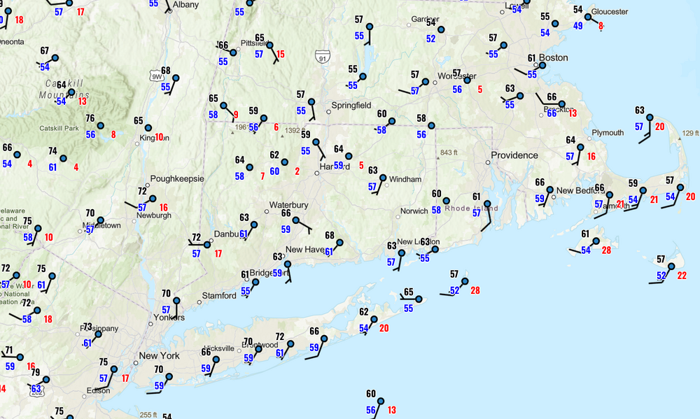
Temp ? I've been monitoring this site all morning ( provided by the Grand Rapids MI NWS ) and you can see/get a feel for where the warm frontal erosion axis is...
-
mid 60's and pokes of sun, more humid
-
Not wedged here, just need junky mid level shit to get out of here.
-
Yes sir. We have rented out Greystone Public House - have friends flying in and driving in from all over the east coast all today (a few fly tmrw am so hope that is before the lines develop).
-
I agree 100%. From everything I read he is a great poster and a very smart guy, but absolutely lets his bias get in the way. As I posted a few posts up, our snowfall is just slightly below avg the past decade despite multiple warm winters, and our 20 year avg and 30 year avg are STILL slightly above longterm avg. The area also saw some 10-15" MORE snow in 2019-20 & 2022-23 than we did in '24-25, and those were winters 5-6° warmer than 2024-25 (but '24-25 saw more days with snow on the ground - THAT is the bigger connection to temps). Plus we aren't a feast or famine climate like yours. It's not always about temps. Climate, pattern, and storm tracks play a big role. A pattern conducive to noreasters will quickly shoot up snow totals on the east coast, regardless of winters final mean temp.
-
Yeah it’s doable, but it’s hard stuff. Terrain and chase infrastructure are horrible. It’s more risky to chase out here than the Midwest. More open spaces like NY can be good though if you’re in the right spot.
-
-
It's becoming sad, as he obviously is a good poster, but his head has become so clouded now is downright laughable. Talk about letting your bias get in way, lol. You are 100% right, we went through a stage where we averaged a good 7" or so more than normal for 20 years. Now since 2016 it is a below average stretch and the new norm. So delusional.
-
Headed to the game Sunday. Think the afternoon is a washout?
-
It is an absolute guess as to whether or not your region will get another very snowy period. ESPECIALLY with the feast/famine nature of your climo. You JUST had the snowiest time on record a short decade ago. You think there wasnt warming in place already when that snowy spell occurred? I remember back in the late '90s when global warming was a hot media topic and we had a string of mild winters, we heard that "by 2020 this will happen and that will happen and it wont snow" blah blah blah and we proceeded to see the 2000s and 2010s produce multiple severe winters. And whats more, these predictions for a future of radically different weather than was seen in the past are nothing new. Its been going on for centuries, and it never materializes.
-
There is a farm on Rte 66 in Columbia, right near the Hebron line, which I've always thought would be a great place to storm watch from, as it has a great view to the west. But it's obviously private land and I'm not sure they'd be excited to have people pulled off the road on their property.
-

Central PA Spring 2025
Itstrainingtime replied to canderson's topic in Upstate New York/Pennsylvania
I thought the same thing this morning...maybe because there wasn't much of a breeze but regardless, it felt every bit like a July morning. -
Central PA Spring 2025
Itstrainingtime replied to canderson's topic in Upstate New York/Pennsylvania
Have a great day! Eating local? -
April checked in at +0.61C [versus 1991-2020] on UAH V6.1.
-
Your sky's gotta be glowing at least now looking at high res vis loop. We may actually scour out prior to the real warm front moving through over the course of the next several hours ... but, if that happens the high intense sun will then process the shit out of the prefrontal inversion and we may see a "frontal leap" up to a bicycle ride S of Brian where it stalls until next spring
-
GFS has much of it staying west of us again and most of our subforum about an inch or so over the few days. This can still evolve in a way that’s mostly just chilly east wind mist and occasional light rain.
-
Muggy out. Picked the wrong time to decide on bedlining the truck bed (needs 5 days without touching water) but all the prep work needs to get done.
-
No thunder here, reported 0.17" at 7 AM. Currently in a small patch of moderate RA and upper 40s. Spring signs - inch-long sugar maple and hophornbeam leaves though oak/ash still asleep. Less pleasant - fetched 2 deer ticks day before yesterday as I was measuring the trees I've tracked biweekly May-Sept since 2012.
- Today
-
When the hell is it going to warm up? Just reached 60
-
Last night about 5am was a nice mini event. Gave me just enough juice to keep me happy for a few days. Hopefully something transpires tomorrow even if likely to be non severe
-

E PA/NJ/DE Spring 2025 Obs/Discussion
LVblizzard replied to PhiEaglesfan712's topic in Philadelphia Region
Wouldn’t be surprised to see tomorrow upgraded to a slight risk. Looks pretty decent for some severe wx. -
You should be getting feedback here for good elevated locations to track. I will give 3 near me although my part of SNE is where Storm come and die. RT 31 Dresser Hill in Charlton Mass, just prior to the food stand) great view looking west. RT 31 in Dudley Ma, at the water tower looking S and E RT 49 in Sterling CT near the Ekonk Hll Farm, great view N and W
-
We probably have a shot at something tomorrow night. Euro and ukie still seem way overdone
-
I've actually seen some damn good storms doing it.. and 6-1-11 one of the best storms I've seen in Northampton then coming home from that storm the Springfield tornado
-
Going to be an interesting anniversary dinner party for us.


.thumb.jpeg.f5c6ba9d911ec96b3b124f8606aee58e.jpeg)


