All Activity
- Past hour
-
might be that I didn't actually measure here, and what I saw was already compacted. Plus from what I am seeing online, reports 8-9" all around here. so it could be correct, and I could certainly be wrong.
-

Central PA Fall Discussions and Obs
Itstrainingtime replied to ChescoWx's topic in Upstate New York/Pennsylvania
Outside of some showers the GFS looks really dry over the next couple of weeks. -
Man K street in D.C is where all the action happens
-
Definitely some better lift at 700 and 850 on the 12Z FV3 for northern third of NC, especially western half. Probably will be the keys to how strong these levels will be and ultimately precip. Just my opinion.
-
We may have to toss December
-
 So any updated head count?
 -
That works for December..Rather be in phase 8 than 4 or 5 which we have seen numerous Decembers.If this is true should be an exciting holiday season this year.
-
I can definitely believe it. Continuation of last winter’s crap.
-
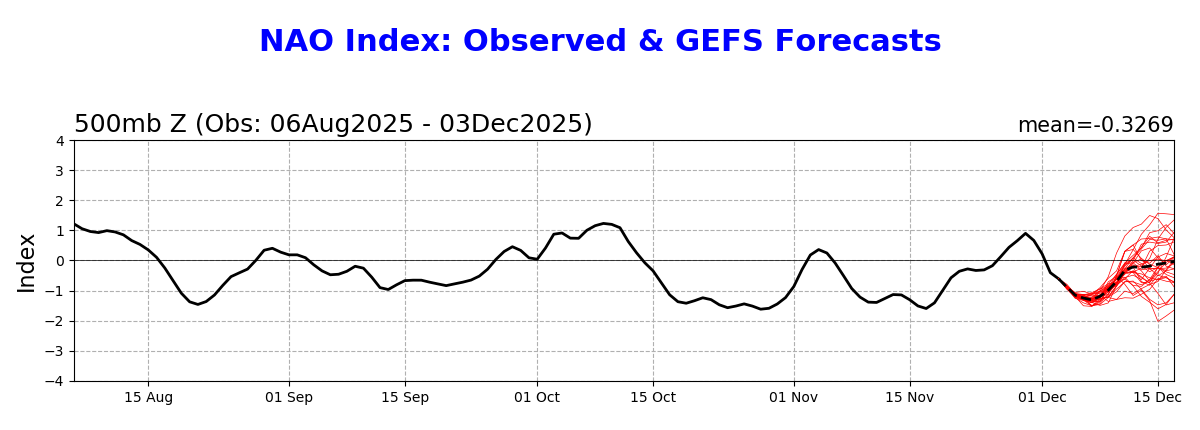
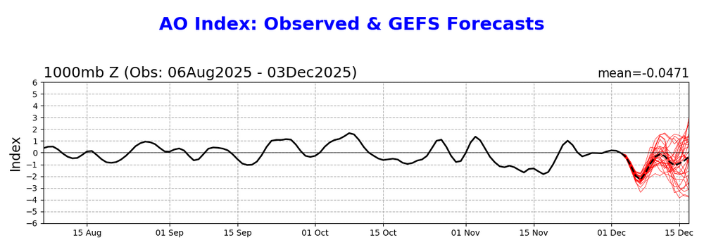
Regardless, there’s been and looks to continue to be plenty of winter (cold and/or wintry precip) in most of the E US through the first half of Dec at least. Despite the weak -PNA, there’s a very rare combo of a very long moderate amp phase 8, a -NAO, and a -AO to more than compensate. -NAO: wasn’t seen dominating the 1st 1/2 of Dec as recently as 5 days ago -AO: wasn’t seen dominating the 1st 1/2 of Dec as recently as 5 days ago

-

December 2025 regional war/obs/disco thread
Damage In Tolland replied to Torch Tiger's topic in New England
The long ones we skim -

2025-2026 New England Snow Recordkeeping Thread
mreaves replied to bristolri_wx's topic in New England
I entered my totals this morning and looked the summary but I don't see where I left anything open or did anything to it. -
December 2025 regional war/obs/disco thread
Damage In Tolland replied to Torch Tiger's topic in New England
1/4 “ -
Mid month ridge looks transient
-

December 2025 regional war/obs/disco thread
weathafella replied to Torch Tiger's topic in New England
Getting back to earlier in the thread-in the years I’ve been posting, I’ve never put anyone on ignore. Reading posts I don’t like is part of the fun. -
12z NAM has snow breaking out in KS at 84
-
Richmond is the new Westminster
-
December 2025 regional war/obs/disco thread
weatherwiz replied to Torch Tiger's topic in New England
Not often you see MET exceed MAV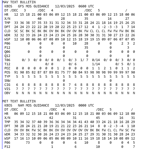
-
Truly horrrific
-

Kick-Off '25-'26 Winter Storm Obs
AstronomyEnjoyer replied to 40/70 Benchmark's topic in New England
7.3" total here in Bradford. Not too bad. -
A little bit better for you, but it wasn’t obvious to me looking at the radar. 7 inches on the ground this morning and most spots. So probably with settling we had about 7 1/2.
-
Same ol pattern. Fast Pac jet won't let much turn the corner or phase
-
Again courtesy of the MA forum. Its the NAM so grain of salt at this range but would fit the last few years where the Delmarva schoold our area w/r/t %of average snowfall lol.
-
A shame Friday won’t work out. Cant believe mid Atlantic snows before us
-
I'm not feelin a nam like solution with qpf but I do like all guidance running a measurable stripe through my region. Pretty sold on the 1-2" potential. Above that is possible but light events are what they are. H5 is pretty flat. 100% stoked that it's a daylight event with a start around sunrise.
-