All Activity
- Past hour
-
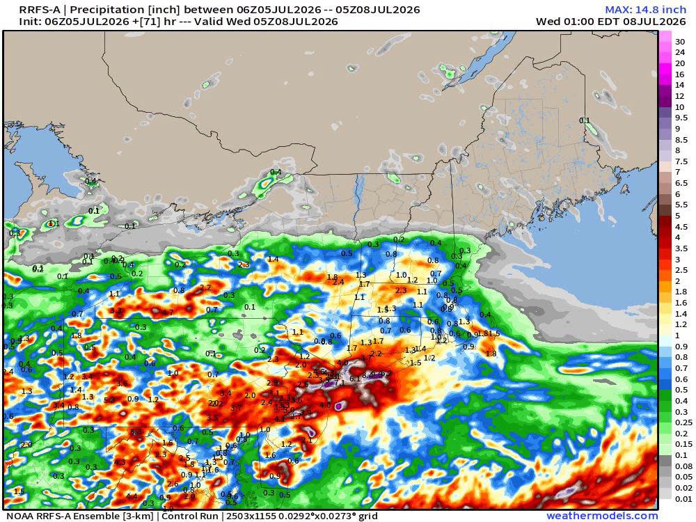
 The RRFS? Found it quickly . Might not be right but wagons def south for heaviest
 -
.thumb.jpg.6a4895b2a43f87359e4e7d04a6fa0d14.jpg)
Central PA Summer 2026 Discussion/Obs Thread
Yardstickgozinya replied to Voyager's topic in Upstate New York/Pennsylvania
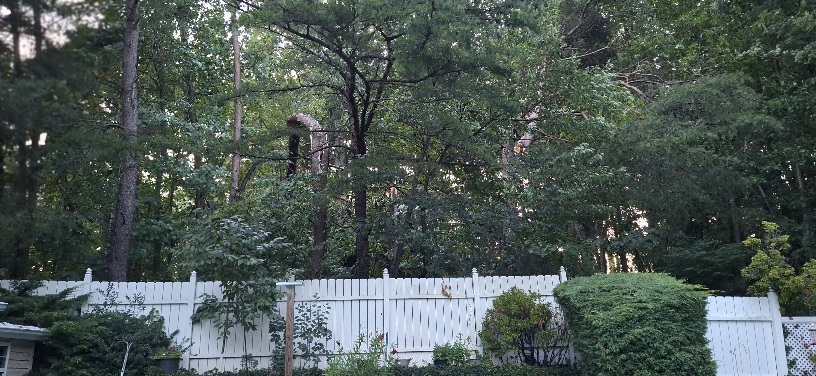
The one thing I noticed every place had in common along my drives last night, and this morning was the smell of freshly cut timber. I think a lot of people are going to be surprised about how widespread and damaging ithis wind event actually was as pictures and stories roll in. Some of the hardest hit places along my drives were the Heritage golf course in Lisburn, neighborhoods surrounding the I81 and Carlisle pike Interchange, areas around Cedar, Cliff high school, including the Cliffs, and the north end of Greenlane farms. My son also sent me pictures from front street in Harrisburg and I can also confirm that that area seems particularly hard hit. Unfortunately, driving last night required extra attention so I got very few pictures and videos ,but seeing the damage fresh leves, no doubt in my mind that this was the worst windstorm in my hometown and many surrounding areas in my lifetime. The picture below is what it looks like outside my sliding door and looking directly back at it from my woods. I lost four large connifer trees just in that view. I also lost 2 large poplar trees and small dogwood and had several deadfalls.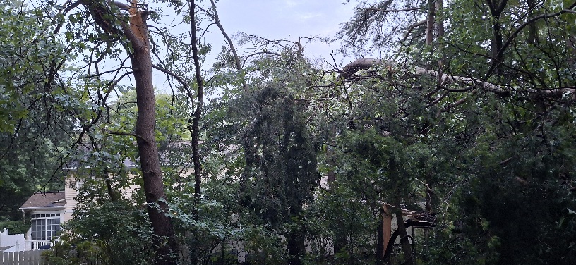
-
 That’s the future right there
 -
There is a flood watch posted for a wide region. Even a historic heat wave with high dew points does not result in a decent rainfall at the end, pretty pathetic.
-
Min 56.3° Kinda chilly A few models are tickling some precip up here on Tue. Just asking for 0.75”+.
-

Big Heat (and storms?) Week into July 4th Weekend
MN Transplant replied to yoda's topic in Mid Atlantic
0.06” -
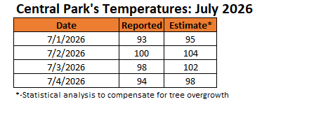
As had likely been the case during the record June 2025 heatwave, Central Park likely had two 100° or above days during the most recent heatwave. Only one such day was recorded due to Central Park's well-documented tree overgrowth. Moreover, July 3, 2026 was likely one of Central Park's hottest days on record, as was the case at surrounding sites: JFK Airport: 102°; LaGuardia Airport: 104°; and, Newark: 105°. As noted previously in this thread, I would run the statistical analysis based on the most recent 30-year period prior to the issue of tree overgrowth. The numbers are below.
-
The fireworks display at Wisp was awesome. Had a few sprinkles ~8PM which dropped the temp into the mid 60s so it was quite refreshing. What was super strange was after we got back home and turned on the Cubs game, Wrigley Field looked like the London Fog of 1952 - even delaying the game due to fireworks smoke. I used to live within walking distance of Wrigley and don't remember fireworks let alone those kind of after effects (I realize the wind was calm, etc.). Hit 88 yesterday and so, never reached 90 this past week.
-
0.20” for 7/4 imby/Columbia, which is also the monthly July total at this point. Not much rain, but still a fairly nice watering of shrubs, grass, etc.
-

Central PA Summer 2026 Discussion/Obs Thread
mahantango#1 replied to Voyager's topic in Upstate New York/Pennsylvania
-
 Lol you really dug to find that one.
 -
Yeah by radar that storm looked very severe.
-
Central PA Summer 2026 Discussion/Obs Thread
mahantango#1 replied to Voyager's topic in Upstate New York/Pennsylvania
PPl customers without power. Customers currently without power: 125,284 Last Updated: Jul 05 07:30 AM -

Central PA Summer 2026 Discussion/Obs Thread
Jns2183 replied to Voyager's topic in Upstate New York/Pennsylvania
They managed to put road blocks by the downed trees, haha. The people without power barely moved all night, so I suspect this may be a long long duration event. It sucks I can't even get ice to save my food Sent from my SM-S731U using Tapatalk -

Big Heat (and storms?) Week into July 4th Weekend
dailylurker replied to yoda's topic in Mid Atlantic
The drought just keeps winning. Boring ass weather continues. -
.
-
Wasnt a fun storm… lost some trees and an xbox :/ .
-
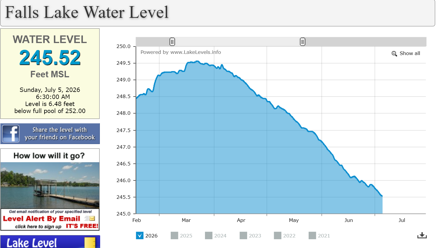
It is basically falling at its steepest rate since the real drop began. Showers over the next few days should slow or stop the bleeding for a short time.

-
Nothing but some light rain last night in Vienna. Overcast sky.
-

E PA/NJ/DE Summer 2026 Obs/Discussion
Hurricane Agnes replied to PhiEaglesfan712's topic in Philadelphia Region
Ended up with 0.32" of rain which I guess is better than nothing but am hoping for more the next couple of days to get all this heat-storing infrastructure cooled down. Looks like I bottomed out at 72 and it's currently overcast and 73 with dp 72. -

Big Heat (and storms?) Week into July 4th Weekend
BlizzardNole replied to yoda's topic in Mid Atlantic
0.89 from last night is the total so far and is probably similar for PF. Based on radar, I think they got a lot more down in the southern part of the county. Forecast has us dry here through tonight and more showers tomorrow. Other than last night, it has been extremely dry here. -
Central PA Summer 2026 Discussion/Obs Thread
Yardstickgozinya replied to Voyager's topic in Upstate New York/Pennsylvania
No morning update from the Spc yet but the national weather service seems pretty confident we are going to see more severe weather in cpa today. Highlight Changed Discussion -- 998 FXUS61 KCTP 050843 AFDCTP Area Forecast Discussion National Weather Service State College PA 443 AM EDT Sun Jul 5 2026 .WHAT HAS CHANGED... * Dense Fog Advisory issued early this morning for the western and central Alleghenies * Targeted Moderate Risk Excessive Rainfall Outlook (level 3/4) for east-central Pennsylvania through tonight * Flood Watch issued this afternoon through Monday for east- central Pennsylvania && .KEY MESSAGES... 1) Breakdown of heat wave pattern gives rise to severe storms and torrential downpours today and Monday && .DISCUSSION... KEY MESSAGE 1: Breakdown of heat wave pattern gives rise to severe storms and torrential downpours today and Monday 40 severe thunderstorm warnings issued in the past 2 days. The days following a transition from an extreme heat pattern are often marked by severe/active weather, and that trend continues through at least Monday. As the heat dome shifts to the west and troughing develops over the Great Lakes/Ohio Valley/Northeast, the upcoming week will feature relatively cooler (more seasonal) temperatures with a bullish signal for almost daily rain chances particularly early and late in the week. In the very near term, clearing sky and nearly calm wind following last evenings widespread rainfall has resulted in areas of dense fog over the western and central Alleghenies. IR sat shows the fog expanding as higher clouds peel away. We issued a DFA through 13Z/9AM with several ASOS and RWIS sites already reporting 1/4 mile visibility. Another active wx day ahead with dual severe T-storm and flash flood risks to manage. We anticipate another diurnal uptick in convective development within a very warm, moist and increasingly unstable environment indicative of steep low-mid level lapse rates. Pockets of stronger deep layer shear 30+ kt may exist in the upper OH Valley and eastern PA, but the general expectation is for pulse to multicell storms to once again merge/form into line segments with some cold pool organization to promote damaging wind potential from mid afternoon into the evening. SPC placed the highest damaging wind probs near/southeast of I81/78 where max temps should reach 90F. Focus will should evolve from severe to flash flood/hydro ops by later this evening and continue into Monday as a robust +RA signal continues to manifest over east-central PA. Atmos conditions will be quite favorable for heavy rainfall and flash flooding potential with 2+ inch pwats correlating to intense rain rates >2 in/hr and repeating/back-building storms along q-stnry/wavy frontal zone. Latest HREF/REFS mean QPF guidance is signaling 1-3" in the 24hr period ending 00Z Tue with PMM/LPMM max values exceeding 5 inches. WPC coordinated a targeted and relatively small moderate excessive rainfall outlook (level 3/4) within a broader level 2/4 or SLGT risk area. We issued a relatively large/broad flood watch along with WFO PHI as there remains some spatial uncertainty to exactly where the greatest rainfall will occur. The setup (multiple rounds of slow moving/torrential downpours) favors locally significant flash flooding particularly in terrain areas and highly urbanized corridors. One limiting factor is obviously the drought conditions and corresponding elevated FFG values that may offset the overall risk to some extent https://forecast.weather.gov/product.php?site=CTP&issuedby=CTP&product=AFD&format=CI&version=1&glossary=1&highlight=off - Today
-
.14"
-

Big Heat (and storms?) Week into July 4th Weekend
Weather Will replied to yoda's topic in Mid Atlantic
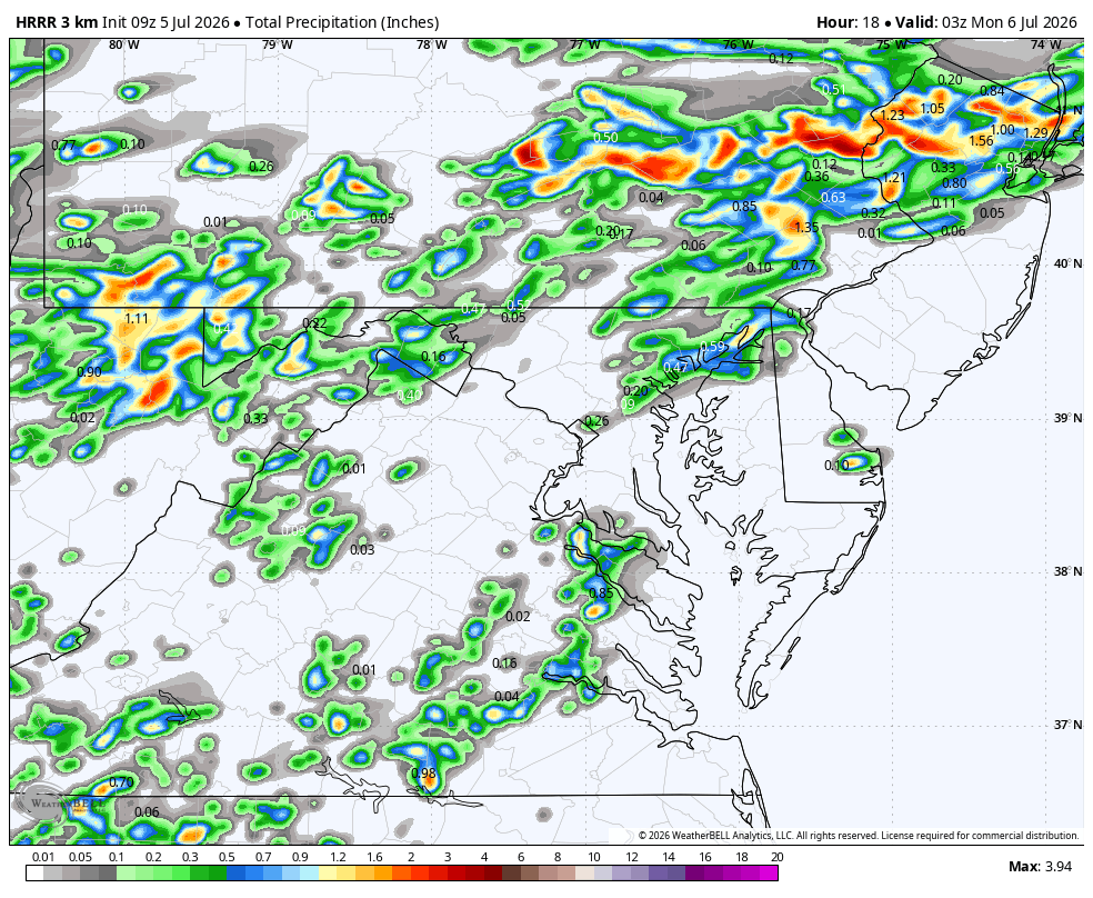
WB 9Z HRRR pretty quiet today....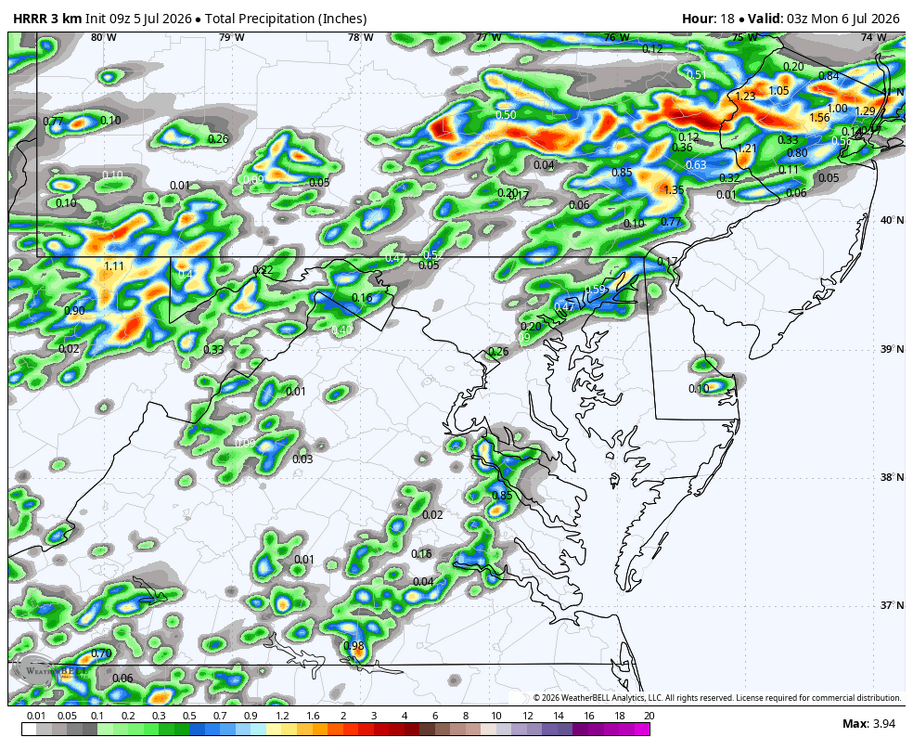


.thumb.JPG.418e8a9a2902ae687ec35ff4bc0e038e.JPG)