All Activity
- Past hour
-
I'll agree with Jan and Feb, but March is a stretch in my area. We can all dream though.
-
We just hit 78!!! Another 80 degree day possible?
-

November 2025 general discussions and probable topic derailings ...
CoastalWx replied to Typhoon Tip's topic in New England
Let’s do that euro. Balls cold in between rains. -
Not sure. Stratospheric warming is supposed to bring down colder air, although I'm not sure this exact scenario as pictured will materialize...
-

November 2025 general discussions and probable topic derailings ...
ineedsnow replied to Typhoon Tip's topic in New England
We snow! -
I assume that future AI models will be excellent, being able to correct biases, and errors from the last run if initial 6 hour forecast(s) don't verify. Anyways, I'm optimistic (for once)...
-
There's very little support on any of the major ensembles for much snow through 10 days... or even 12 days (corrected, the GEFS shows the Dec 4/5 potential wintry event). It looks relatively active with cold air not too far away, but the multi-guidance consensus suggests the progression and evolution of the longwave pattern is not locally favorable. Even the individual members are stingy with wintry outcomes for the moment. Early December is still highly trackable... and we know that ensemble members group too close to the parent model, so favorable changes are still possible especially out past 7 days.
-
You are correct - checkout the 12Z AI much different from the 6Z BUT some amature Mets on youtube will probably make a big deal out of the 6Z run
-
Thank you for the kind words. It’s good to see that we can each use different methods and converge on similar solutions. You do a fantastic job putting together your seasonal outlooks. It’s why this extended format discussion forum is such a valuable resource bringing us all together in the same spot.
-
At the game today. My god the offense looks like shit
-

2025-2026 ENSO
40/70 Benchmark replied to 40/70 Benchmark's topic in Weather Forecasting and Discussion
Excellent post...mic drop- -
2025-2026 ENSO
40/70 Benchmark replied to 40/70 Benchmark's topic in Weather Forecasting and Discussion
Se Canada will be cold...they can cut all they want, it will have to snow at this latitude to advect the warmer air from the inland primary, and a triple point low will pop INVO cape cod as a byproduct of the initial resitance from the CAD. -
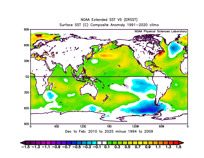
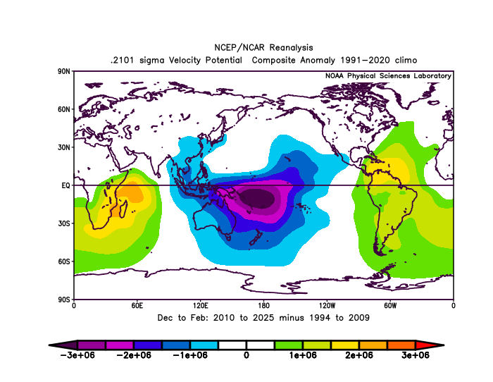
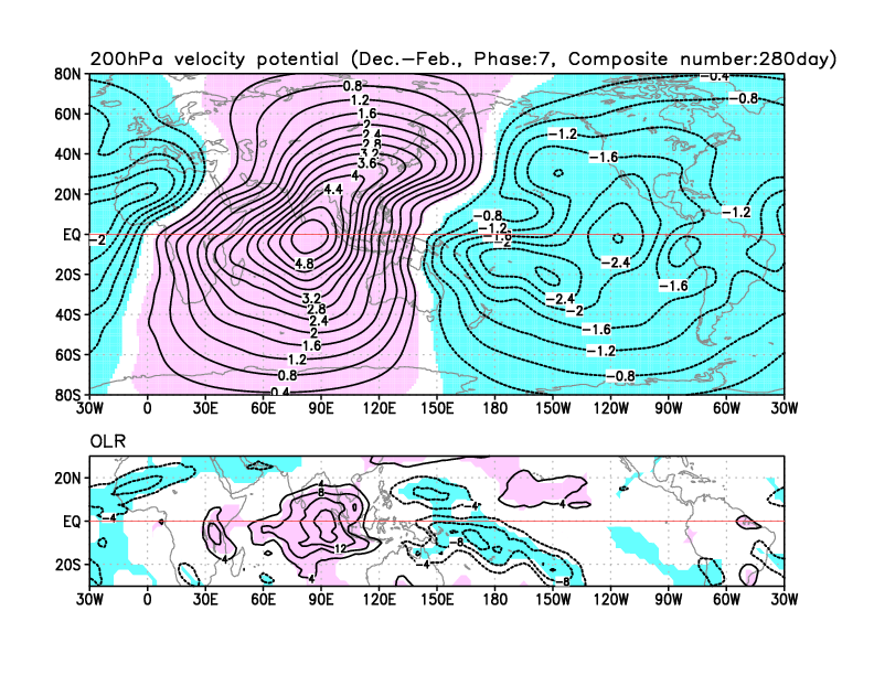
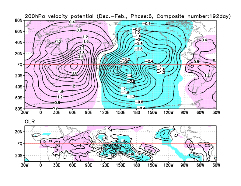
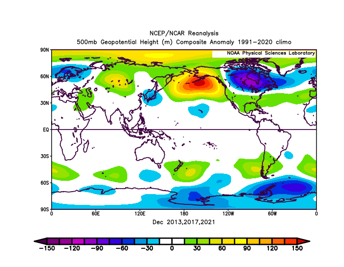
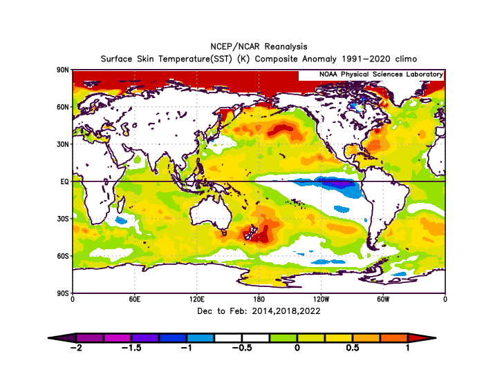
Yeah, this is what I have been discussing. The rapid warming of the WPAC tropical SSTs near the near the Maritime Continent has been stalling the MJO in the warmer storm track and background temperature phases. So the MJO progression tends to linger longer in the 4-7 phases and spend less time in phase 8. This is why January 2022 was the last time that the RMM and VP anomaly charts were both solidly in Phase 8. From March 2022 through the winter of 2024-2025 the few MJO 8s per the RMM charts had lingering forcing in phase 5-7 regions. So we didn’t fully realize the MJO 8 pattern which we last had in January 2022. Many times the models try to rush the progression through phase 8 and it gets delayed and or weakened the closer in time we get to the forecast period. This is what is shown when we subtract the last 16 years from the previous 16 years. You can see the stronger forcing closer to phases 6-7 where the warmest SSTs on earth near +30C are found during the winter. This +28C +30C warm pool has been steadily expanding across that region.
-
Amazing job! Thanks guys .
-
yes, it's real. It's a long range forecast that's been somewhat consistent with the GFS and ECMWF the last couple of days, I think
-
Yeah clouds again hanging on and pushing in
-
2025-2026 ENSO
40/70 Benchmark replied to 40/70 Benchmark's topic in Weather Forecasting and Discussion
I have a learned a ton from your material. -

2025-2026 ENSO
so_whats_happening replied to 40/70 Benchmark's topic in Weather Forecasting and Discussion
Honestly I wish it could be as simple as saying we are going into a phase 8 pattern thus it should look like this. The issue going on is we are still in a Nina like background state but we are getting intrusions of Nino like features popping up. I honestly never thought this setup would work out as well as it is. Lets see how things continue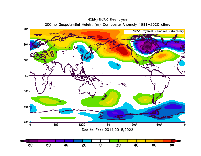
-
I think you will. 12z models are showing a better press with the storms ahead.
-
2025-2026 ENSO
40/70 Benchmark replied to 40/70 Benchmark's topic in Weather Forecasting and Discussion
I'll bet you $100 I have a plowable event of 3" or greater by the end of the second week of December (14th). - Today
-

November 2025 general discussions and probable topic derailings ...
H2Otown_WX replied to Typhoon Tip's topic in New England
When the pattern comes together "I know the pieces fit" -
Well, we are back to zero because the Euro just came in way different at the end of the week. Last night the Euro looked like the GFS, but now it has suddenly pulled all the energy back into the western US and pulls a bunch of warm air up into Iowa so we get rain.
-
Torching here. Sunny and the temp has jumped to 59 after a morning low of 29. West wind gusting to 30.
-
So much for that mostly sunny forecast!
-
 We'll all hands and sing Kumbya once a good snowstorm hits.


