All Activity
- Past hour
-

Friday February 6 FROPA / WINDEX small event
NorEastermass128 replied to HoarfrostHubb's topic in New England
Puking snow. -

Friday February 6 FROPA / WINDEX small event
The 4 Seasons replied to HoarfrostHubb's topic in New England
0.9 and steady light snow. nice refresher -
I haven't been out yet but it looks covered out there. It looks like an of snow where I had dug a patch through the pack. I got up and watched it come through. It came down real nice.
-
Looks like I got hit pretty flush with the snow along the Arctic front based on radar. But it’s all blown away…
-
Euro ai and gfs ai like Presidents’ Day…. Little warm for nyc south big totals north and New England
-

E PA/NJ/DE Winter 2025-26 Obs/Discussion
MickeyTim6533 replied to LVblizzard's topic in Philadelphia Region
6z GFS says what storms? -

Friday February 6 FROPA / WINDEX small event
TauntonBlizzard2013 replied to HoarfrostHubb's topic in New England
Very light dusting. Enjoy those getting the goods. We knew here -
Wow euro AI overnight looks like light snow 11-12, big storm 15-16, light or cutter 15-16, big storm 20-21
-
Holy SHIT! complete whiteout blizzard for 10 minutes! Had to gust to 50 MPH
-

E PA/NJ/DE Winter 2025-26 Obs/Discussion
Birds~69 replied to LVblizzard's topic in Philadelphia Region
Not sure how much but it’s whiter out there than before bed. Nice stream coming down over my area…NW-SE
-
This is one of the more intense flow events I've seen in Boone/Blowing Rock, having lived here a bit over a decade now. Interesting considering we are much warmer and less windy than forecast. Guess the banding has set up right.
-
Next weekend has potential. Ensembles continue to increase.
-
Friday February 6 FROPA / WINDEX small event
The 4 Seasons replied to HoarfrostHubb's topic in New England
looks that way Washington/Kent counties are also getting smoked right now
-
 6Z GFS has nothing like the EURO AI. The 6Z GFS AI improved but still too warm and weaker than EURO AI.
 -

Friday February 6 FROPA / WINDEX small event
Modfan2 replied to HoarfrostHubb's topic in New England
Looks like you can see the heavy areas in S RI and NE Mass starting to set up on radar -
Thats one for the record books, even though i didnt get those 20 burger amounts it was still one of the greatest storms ive ever experienced. 7F and S+ during daylight hours the whole day is unbeatable.
-

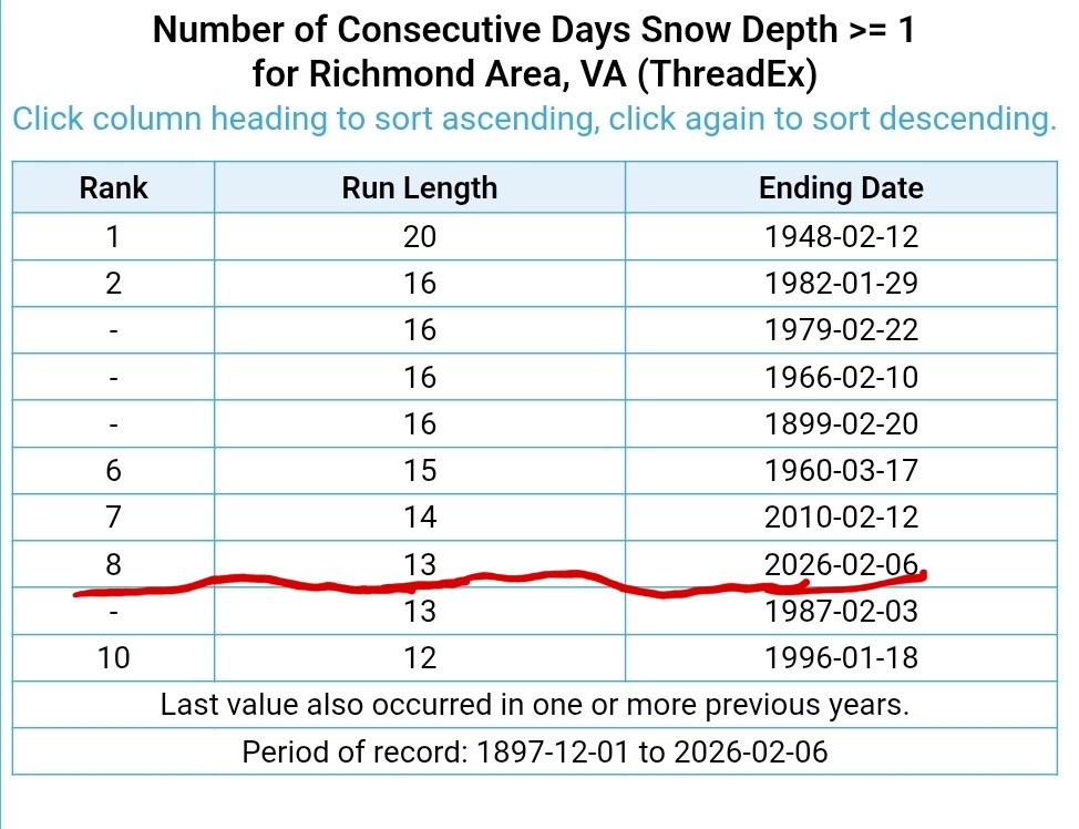
Richmond Metro/Hampton Roads Area Discussion
migratingwx replied to RIC Airport's topic in Mid Atlantic
Looks like RIC is at 11.0” for the season. Last year’s total was 11.7” Also, at least 1” of snow (including sleet) has been on the ground for 13 straight days in Richmond. This is the longest stretch of snowcover 1” or more since the 2009-10 winter. With this weekend’s cold, it’s likely this will increase to at least 15 days, which means it could be the longest stretch since 1982.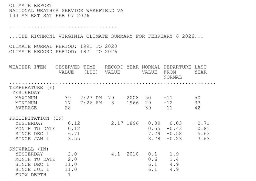
-
Models all over the place next week. Hopefully it settles down by Monday.
-
Friday February 6 FROPA / WINDEX small event
Modfan2 replied to HoarfrostHubb's topic in New England
2” here so far, temp 24F -
Looks like a snow squall must’ve come through, everything is more covered in snow than when I went to bed. Wind is cranking now behind the front.
-

Winter 2025-26 Medium/Long Range Discussion
A-L-E-K replied to michsnowfreak's topic in Lakes/Ohio Valley
Zzzzzz -

Friday February 6 FROPA / WINDEX small event
Ginx snewx replied to HoarfrostHubb's topic in New England
That's the Arctic front -
I have a quick question about whether the NWS "Forecast Discussion" has changed. The NWS seems to have dropped the "long-term" section of the discussion in favor of "key messages". I had thought it was the result of my moving to a different NWS area, but Mt. Holly seems to have made this small change as well. The long-term section was not that long ahead, usually just 4-5 days or so, but discussion of it seems to have much diminished. Is this my imagination or has this been an across-the-board slight change?
-

Friday February 6 FROPA / WINDEX small event
Chrisrotary12 replied to HoarfrostHubb's topic in New England
Beverly, MA going to end up with like a foot aren’t they? -
Friday February 6 FROPA / WINDEX small event
Ginx snewx replied to HoarfrostHubb's topic in New England
I would push 6 plus if they verified.png.6713fe6661a0669419e0aa2328dd6f29.png)
.png.23098054523484b0ff4c2ea3edfadf2b.png)