All Activity
- Past hour
-
Fireworks can F off
-
Heckuva storm in Owings Mills. Might have been the strongest winds I’ve seen since moving here in ‘18. Heard there power outages in Owings Mills and Reisterstown and a tree fell on house in Reisterstown as well.
-
We can agree. Snowenoutthere, a college student, wrote eloquently about rejecting this type of nihilism. I don't know who you're arguing with here but you keep trotting this out, a bit like a strawman, which is a..you know what. Anyway there's a separate forum for this whole discussion and I'm probably about to get in trouble. Why don't you share your take on the science there (not the nihilism, we get that).
-
Yes was sick. Lighting bolts and fireworks
-
Watching fireworks and lightning was something else. Rain missed a mile to my north.
-
House shaking thunder and people are still shooting off fireworks
-
 BLM and DOV were ASOS…AO2 ESN was manned in the evening BLM did have TS without precip METAR KBLM 131956Z AUTO 13005KT 10SM FEW044 SCT060 BKN110 34/27 A2988 RMK AO2 TSB00E16 SLP117 T03390272
 -
 Nice long steady rain some booms
 -

Central PA Summer 2026 Discussion/Obs Thread
Jns2183 replied to Voyager's topic in Upstate New York/Pennsylvania
I'm still amazed it did that to a healthy tree Sent from my SM-S731U using Tapatalk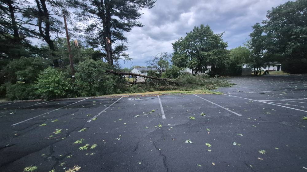
-
Not even a drop of rain here. Cool lightning in the background with fireworks though. High was 97 today
-
Central PA Summer 2026 Discussion/Obs Thread
Jns2183 replied to Voyager's topic in Upstate New York/Pennsylvania
Powe has till 10 am tomorrow to come in at my restaurant or else we are filing a $50k insurance claim and I have a week from hell on the backend Sent from my SM-S731U using Tapatalk -
Got skunked today which is good. Strong storms went north and south of me.
-
.thumb.jpg.6a4895b2a43f87359e4e7d04a6fa0d14.jpg)
Central PA Summer 2026 Discussion/Obs Thread
Yardstickgozinya replied to Voyager's topic in Upstate New York/Pennsylvania
No shortage of crews and people still out here clearing debris out of roads and off of homes. Fireworks and generators glore out here tonight. -
just wait until DC records the worst air quality ever recorded here in about 2 hours.
-
E PA/NJ/DE Summer 2026 Obs/Discussion
SouthernNJ replied to PhiEaglesfan712's topic in Philadelphia Region
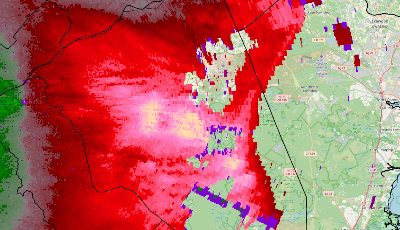
The strongest winds appeared to occur along the many outflow boundaries put out by the storms this evening. Unfortunately, these boundaries also caused weakening of convection and less rainfall for some. The highest number of damage reports were in the western zones where the storms arrived with some daylight remaining. Currently, the strongest winds are near Pemberton in Burlington county.
-

Central PA Summer 2026 Discussion/Obs Thread
Itstrainingtime replied to Voyager's topic in Upstate New York/Pennsylvania
Worst part of all of this, tomorrow offers an opportunity for even more destructive winds affecting an even larger area. That's in addition to the flash flood potential tomorrow into Monday night. -
Central PA Summer 2026 Discussion/Obs Thread
Jns2183 replied to Voyager's topic in Upstate New York/Pennsylvania
They sent that out here as well it was basically a mass text everywhere. Got to think they're probably running on skeleton crews and they just had one of the single worst blowdowns and a decade Sent from my SM-S731U using Tapatalk -
580 thickness? 60,000 ft I bet occurred w/ such a high tropopause/EL!
-
 By a matter of only a few miles...
 -
 That's good you brought up the DP plot for the day. That 81 on the NJ coast... I think that's KBLM? That's an AWOS so that is likely very suspect.
 -
Well that was quite the interruption. Had to take down tents and bring the bar in in a hurry.
-
 I bet they took a lightning strike.
 -
A few drops fell today. Splitting around Bergen County.
-
absolutely surreal with fireworks going up all around me with a disco ball right overhead at the same time. somehow barely even a tenth. LOL. but the anvil crawlers are something else.