All Activity
- Past hour
-
should see initiation right overhead tomorrow afternoon
-

2026-2027 Super El Nino
so_whats_happening replied to Stormchaserchuck1's topic in Weather Forecasting and Discussion
-

E PA/NJ/DE Summer 2026 Obs/Discussion
PhiEaglesfan712 replied to PhiEaglesfan712's topic in Philadelphia Region
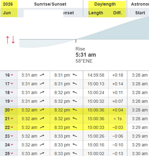
We've pretty much, more or less, stopped gaining daylight at this point. The sunrises and sunsets are just shifting a little bit later each day, but we aren't really gaining or losing daylight. At least not enough for anyone to really notice. We are in the period of maximum daylight. -
.thumb.jpg.6a4895b2a43f87359e4e7d04a6fa0d14.jpg)
Central PA Summer 2026 Discussion/Obs Thread
Yardstickgozinya replied to Voyager's topic in Upstate New York/Pennsylvania
I'm pretty sure I took a picture of it sneaking by me In the rain from pinchot park. -

2026 Atlantic Hurricane Season
WxWatcher007 replied to Stormchaserchuck1's topic in Tropical Headquarters
Flash flooding in the south as odds increase… Tropical Weather Outlook NWS National Hurricane Center Miami FL 200 PM EDT Mon Jun 15 2026 For the North Atlantic...Caribbean Sea and the Gulf of America: Northwestern Gulf of America: A trough of low pressure located over northeastern Mexico is producing a large area of disorganized showers and thunderstorms. Development is not expected during the next day or so while the trough remains inland. However, the system could re-emerge over the northwestern Gulf of America late Tuesday or Wednesday, and environmental conditions there are marginally conducive for the formation of a short-lived tropical storm on Wednesday into Thursday. Regardless of tropical cyclone formation, interests across southern and eastern Texas and portions of Louisiana and Mississippi should prepare for periods of intense rainfall over the next several days which could produce widespread, life-threatening flash, urban, and river flooding. Gusty winds and coastal flooding are also possible along portions of the northwestern Gulf Coast, and Tropical Storm Watches or Warnings could be required on Tuesday. Additional information on this system can be found in products issued by your local National Weather Service Forecast Office or NHC Key Messages. * Formation chance through 48 hours...medium...40 percent. * Formation chance through 7 days...medium...50 percent. $$ Forecaster Blake -
Central PA Summer 2026 Discussion/Obs Thread
Yardstickgozinya replied to Voyager's topic in Upstate New York/Pennsylvania
Spc hasn't been too impressed either. The only one that has any mention of an EML surge has been NWS and they're still holding on to that in their discussion, although I expect changes are coming. -
Flash flooding along the Gulf coast as odds increase… Tropical Weather Outlook NWS National Hurricane Center Miami FL 200 PM EDT Mon Jun 15 2026 For the North Atlantic...Caribbean Sea and the Gulf of America: Northwestern Gulf of America: A trough of low pressure located over northeastern Mexico is producing a large area of disorganized showers and thunderstorms. Development is not expected during the next day or so while the trough remains inland. However, the system could re-emerge over the northwestern Gulf of America late Tuesday or Wednesday, and environmental conditions there are marginally conducive for the formation of a short-lived tropical storm on Wednesday into Thursday. Regardless of tropical cyclone formation, interests across southern and eastern Texas and portions of Louisiana and Mississippi should prepare for periods of intense rainfall over the next several days which could produce widespread, life-threatening flash, urban, and river flooding. Gusty winds and coastal flooding are also possible along portions of the northwestern Gulf Coast, and Tropical Storm Watches or Warnings could be required on Tuesday. Additional information on this system can be found in products issued by your local National Weather Service Forecast Office or NHC Key Messages. * Formation chance through 48 hours...medium...40 percent. * Formation chance through 7 days...medium...50 percent. $$ Forecaster Blake
-
Hope so. Really bad at my location. It has rained some within 5 miles of the house, but ZERO rain here for all of June. NADA. Nobody mowing grass around me at all.
-

2026-2027 Super El Nino
mitchnick replied to Stormchaserchuck1's topic in Weather Forecasting and Discussion
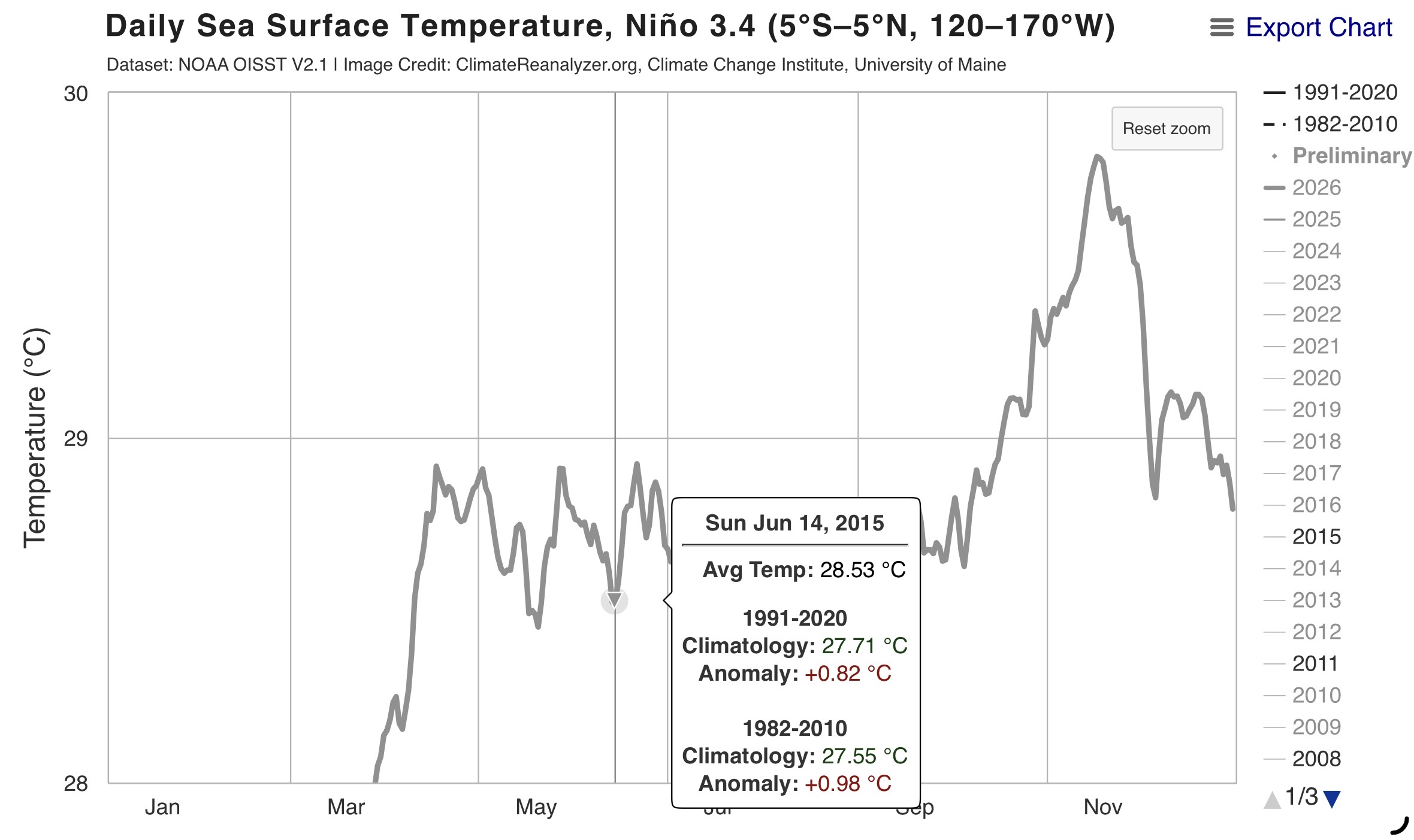
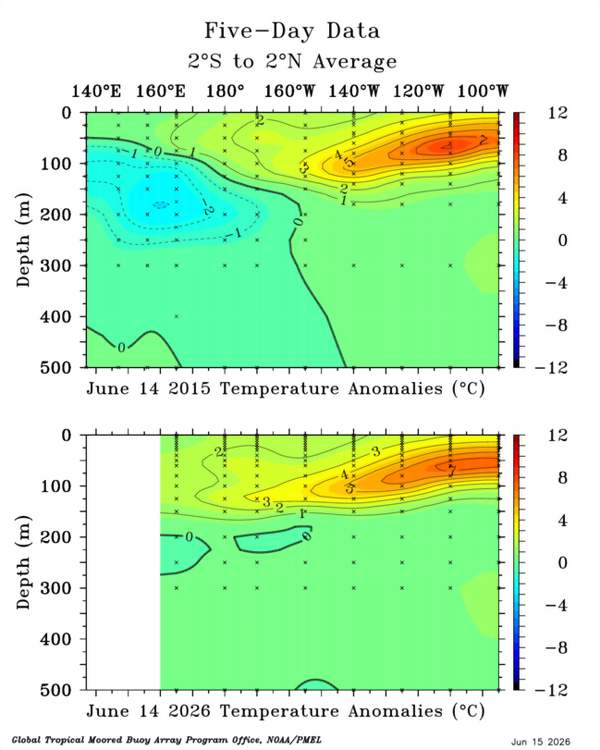
Here are CPC numbers for all 4 Enso areas for 6/10/15 & 6/10/26: 10JUN2015 25.5 2.0 27.8 1.2 28.7 0.9 29.8 0.9 10JUN2026 26.1 2.7 28.3 1.6 29.2 1.5 30.1 1.3ⁿ If you divide Enso 1.2 anomaly into the other 3 areas' anomalies for both years, you get respectively 60%, 45% and 45% in 2015 and 59.25%, 55.55% and 48.15% this year. Comparing the 2 years, Enso 3 is nearly identical for both years and 3.4 and 4 are a hair warmer this year than 2015. Obviously, there may be other ways to figure it, but I'd have to say that they are very similar with a slight edge to 2015 as being more east based under this method. P.s. @GaWx will surely check my math! Lol -

Pittsburgh PA Summer 2026 Thread
TheClimateChanger replied to TheClimateChanger's topic in Upstate New York/Pennsylvania
-

E PA/NJ/DE Summer 2026 Obs/Discussion
Birds~69 replied to PhiEaglesfan712's topic in Philadelphia Region
-
Kind of wondering if this setup is going to over-convect. Several models are showing a line of supercells. May be too much storm competition for a widespread tornado setup. Gonna be interesting to see how this plays out.
-
I drove home from NJ at 10:00 PM last night and it was some of the hardest rain i have ever seen. At points i had to pull over because i couldn't see a thing out of my windshield. It was crazy.
-

E PA/NJ/DE Summer 2026 Obs/Discussion
JTA66 replied to PhiEaglesfan712's topic in Philadelphia Region
We start losing daylight next week. NFL training camps open next month. -
Had a couple good downpours late yesterday. Idk what’s going on, but mby has done well with precip the last couple months.
-
I want to believee
-
I love those maps, its been a while. I'm surprised in OH valley the rec low slps are that high, and the gradient between central ON and central MI.
-
Main action likely to miss east and especially south of here. Should get a nice non severe MCS in the morning though.
- Today
-

2026-2027 Super El Nino
snowman19 replied to Stormchaserchuck1's topic in Weather Forecasting and Discussion
There’s also a big divergence with 2015…this one is way more east-based than 2015 was -

Junorch obs and discussion 2026
Damage In Tolland replied to Damage In Tolland's topic in New England
Steined is the way of the walk . -
dry and semi warm this summer?
-
I’m feeling outshined
-

2026-2027 Super El Nino
roardog replied to Stormchaserchuck1's topic in Weather Forecasting and Discussion
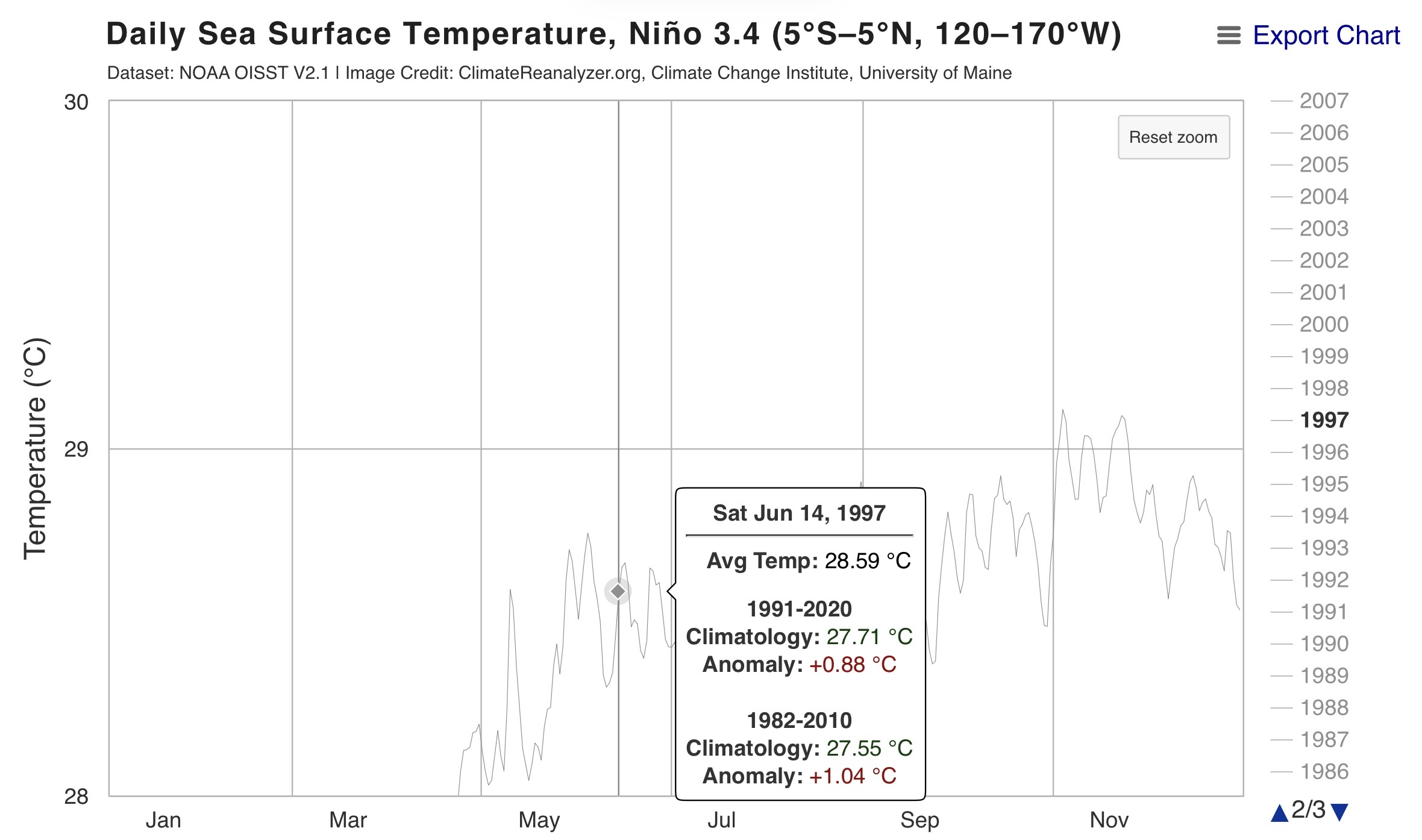
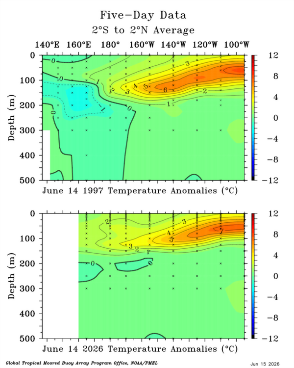
Now that we’re heading through June we can see the big divergence with 1997 is going to be Nino 4. This shouldn’t really be a surprise to anyone but it’s still a big deal IMO. -

2026-2027 Super El Nino
bluewave replied to Stormchaserchuck1's topic in Weather Forecasting and Discussion
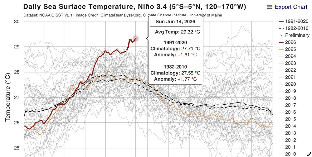
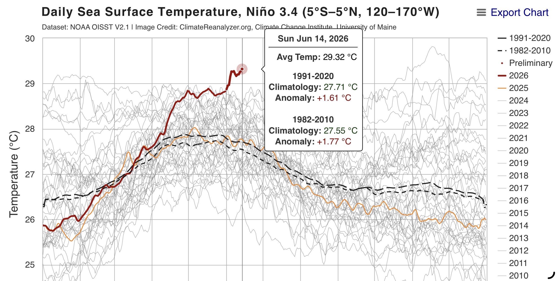
Impressive and record breaking Nino 3.4 lead over 2016 and 1997 for June 14th at 29.32C or +1.61 C.