All Activity
- Past hour
-
My first guess for central Montco is 6-10". Obviously subject to change.
-
Good morning from DFW. Since lived in Rocky Mount NC up until 2017, I still enjoy keeping with the SE forum. We are at the very beginnings of the event here just beside the airport. I work in Irving TX. Currently around 49 * and light to moderate rain. Temps aren't expected to be dropping here until early evening and overnight. That said, the guy I pay attention to most on the TX weather thread on the Central/Western sub forum thinks we are in for a significant amount of sleet in the area. I will post again when things get interesting here. I know there can be a correlation btw DFW and NC weather so it will be fun to see how that works.
-

2025-2026 Fall/Winter Mountain Thread
Rainforrest replied to Buckethead's topic in Southeastern States
Haywood emc is usually pretty good at keeping our right of way cut back pretty good. The only thing that worries me is Duke powers transmission lines Duke sucks at keeping up maintenance on those lines. -

January 24-26: Miracle or Mirage Thread 2
NorthArlington101 replied to mappy's topic in Mid Atlantic
Did nobody post the warning text for us? Wow, we really are fatigued. Don't blame anyone. Only gonna bother sharing the one for DC/Balt -
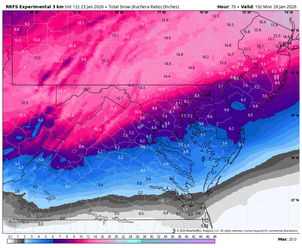
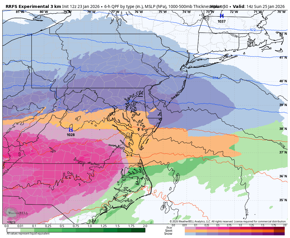
WB 12Z RRFS

-

“Cory’s in LA! Let’s MECS!” Jan. 24-26 Disco
Prismshine Productions replied to TheSnowman's topic in New England
12+ for the entire region Sent from my SM-S166V using Tapatalk -
I’m in the camp that the DC area gets the floor and the Baltimore area gets the ceiling.
-

January 24-26: Miracle or Mirage JV/Banter Thread!
Nomz replied to SnowenOutThere's topic in Mid Atlantic
Are ratios solely based on surface temps, assuming there isn’t an above freezing warm nose? -

“Cory’s in LA! Let’s MECS!” Jan. 24-26 Disco
HoarfrostHubb replied to TheSnowman's topic in New England
Possible depending on the individual location, their DPW, etc. Further east seems more likely -

1/24-1/25 Major Winter Storm - S. IL, IN, MI and OH
Stebo replied to A-L-E-K's topic in Lakes/Ohio Valley
Trending the way it has today sucks, I guess its turning into another boring 2-4 maybe 3-6. -
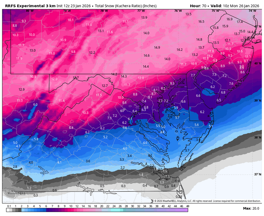
Internal snow ratio gives both DC and Baltimore 9 inches, FWIW. Kuchera is 8.
-

Possible Record Breaking Cold + Snow Sunday 1/25 - Tuesday 1/27
Prue11 replied to TriPol's topic in New York City Metro
Going with 6-10” for my area. -
for some reason the excitement is fading......for SOMOCO
-
 It's not from just one storm - it's happened many, many times over multiple decades in Central NJ. When the mix line or changeover stays south, we often jackpot. But it's very common for us to get 4-6 inches less than from the southern and far eastern portions of Middlesex County to the northern and and further inland portions
 -

January 24-26: Miracle or Mirage JV/Banter Thread!
North Balti Zen replied to SnowenOutThere's topic in Mid Atlantic
Find you someone who loves you as much as this board loves obsessing over the worst possible outcome from any one model in a particular suite ahead of a winter event no matter how unreliable that model is at range... -

1/24-1/25 Major Winter Storm - S. IL, IN, MI and OH
buckeye replied to A-L-E-K's topic in Lakes/Ohio Valley
say what you want, but he remains the consummate professional
-
Possible Record Breaking Cold + Snow Sunday 1/25 - Tuesday 1/27
Prue11 replied to TriPol's topic in New York City Metro
Going to be a nowcast event. -

January 25/26 Jimbo Back Surgery Storm
NorthHillsWx replied to Jimbo!'s topic in Southeastern States
ICON is a massive hit across the board -

Possible Record Breaking Cold + Snow Sunday 1/25 - Tuesday 1/27
winterwx21 replied to TriPol's topic in New York City Metro
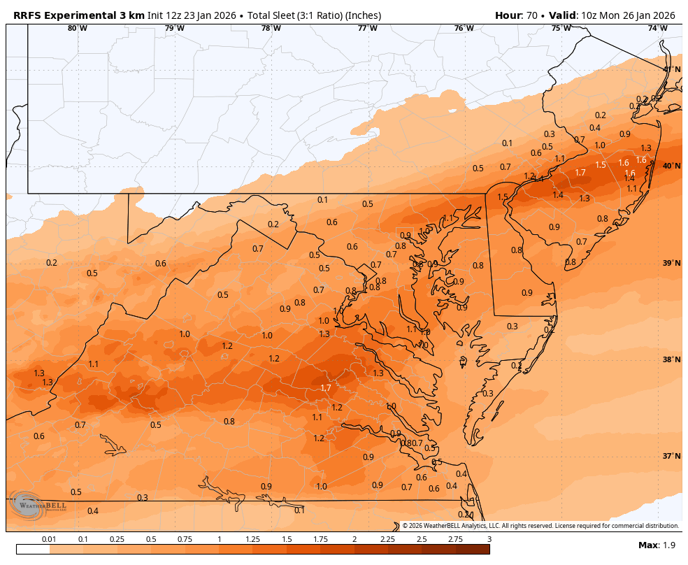
The NAM 3km flips us over to sleet here around 2pm ... that would be lousy. -
And/or ratios higher than 10:1?...
-

Possible Record Breaking Cold + Snow Sunday 1/25 - Tuesday 1/27
weatherpruf replied to TriPol's topic in New York City Metro
that one actually had backend snows though... for me the classics are march 94 and march 2017. that 94 storm was brutal; like the house was being sandblasted. unlike this one, temps were more marginal so it was slushy on bottom; try shoveling 5-6 inches of that..... -
Great test for the NAM replacement. RRFS is what the NWS must be leaning on....orientation of the precip shield is much better. DC gets heavier snow 4-9am Sunday.

-
Kuchie gets Baltimore to a foot. Would be a dream. But probably a couple inches too many. Knock off 2 and I still abscond with that a million percent of the time.
-
 not just that storm... 40 years of watching these overruning events...thump to sleet to snizzle...the end part usually dry slots and we get less qpf than forecast the rgem is what I think will happen for me at least
 -

Central PA Winter 25/26 Discussion and Obs
WmsptWx replied to MAG5035's topic in Upstate New York/Pennsylvania
WARNED URGENT - WINTER WEATHER MESSAGE National Weather Service State College PA 1020 AM EST Fri Jan 23 2026 ...MAJOR WINTER STORM THIS WEEKEND... PAZ004>006-010>012-017>019-024>028-037-041-042-045-046-049>053-058- 240915- /O.UPG.KCTP.WS.A.0002.260125T0300Z-260126T1800Z/ /O.NEW.KCTP.WS.W.0001.260125T0300Z-260126T1800Z/ Warren-McKean-Potter-Elk-Cameron-Northern Clinton-Clearfield- Northern Centre-Southern Centre-Cambria-Blair-Huntingdon-Mifflin- Juniata-Tioga-Northern Lycoming-Sullivan-Southern Clinton- Southern Lycoming-Union-Snyder-Montour-Northumberland-Columbia- Schuylkill- Including the cities of Bloomsburg, Coudersport, Lewistown, Warren, Lewisburg, Philipsburg, Mount Union, Altoona, Lock Haven, Johnstown, Wellsboro, St. Marys, Clearfield, State College, Huntingdon, Laporte, Mansfield, Emporium, Sunbury, Berwick, Trout Run, Pottsville, Danville, Williamsport, DuBois, Mifflintown, Selinsgrove, Shamokin, Renovo, Bradford, and Ridgway 1020 AM EST Fri Jan 23 2026 ...WINTER STORM WARNING IN EFFECT FROM 10 PM SATURDAY TO 1 PM EST MONDAY... * WHAT...Heavy snow expected. Total snow accumulations between 10 and 18 inches. * WHERE...A portion of central Pennsylvania. * WHEN...From 10 PM Saturday to 1 PM EST Monday. * IMPACTS...Travel will be very difficult to impossible. Widespread and prolonged travel disruptions are expected. * ADDITIONAL DETAILS...Snow will overspread the area late Saturday night, becoming heavy at times through Sunday with accumulation rates of one to two inches per hour at times. Frigid temperatures and wind chills are expected before, during, and after the winter storm. Some blowing and drifting snow is possible. PRECAUTIONARY/PREPAREDNESS ACTIONS... Persons should consider delaying all travel. Motorists should use extreme caution if travel is absolutely necessary. && $$