All Activity
- Past hour
-
It will change in a week lol
-
33. Two degrees lower than the forecast.
-

Central PA Fall Discussions and Obs
Itstrainingtime replied to ChescoWx's topic in Upstate New York/Pennsylvania
You enjoy it as well - our kids ages range from 23 up to 31. -
Yup it certainly seems like NC and Virginia are the new new England this winter lol
-

Dec 6-7th (It's not a clipper) Clipper
RogueWaves replied to Chicago Storm's topic in Lakes/Ohio Valley
Not even 1/3 of the way so outcomes rivaling 2000 are still on the table. Tbh, I thought DTW was kinda screwed out of a lot of the big action in 2000. -

The Monday wintry event potential (12/8/25)
Buddy1987 replied to GaWx's topic in Southeastern States
GFS and its nest has been remarkably rock steady. Feel like it has led the way here. -

E PA/NJ/DE Winter 2025-26 Obs/Discussion
Birds~69 replied to LVblizzard's topic in Philadelphia Region
Yep, remember him and his segment. He looked like a scientist or doctor. Remember the "Green Grocer" Joe Carcione... -

December 2025 regional war/obs/disco thread
TauntonBlizzard2013 replied to Torch Tiger's topic in New England
The most interesting thing about this December for me is whether or not this will be year 15 in a row without a white Christmas. Last one was 2010. id love to know when the last time this area went that long, if ever -

The Monday wintry event potential (12/8/25)
BornAgain13 replied to GaWx's topic in Southeastern States
FV3
-
LOL, schools dropping like flies in the last hour, closing for Monday.
-
The Monday wintry event potential (12/8/25)
BornAgain13 replied to GaWx's topic in Southeastern States
0z HRW-WRF
-
Shut up and stop trolling us from New New England.
-
Shit man, sorry to hear. Hope she fires cancer.
-
Latest HRRR and FV3 both get snow up into DC. No help for me out here though.
-

E PA/NJ/DE Winter 2025-26 Obs/Discussion
Voyager replied to LVblizzard's topic in Philadelphia Region
Yup. I remember those days. -
The Monday wintry event potential (12/8/25)
BornAgain13 replied to GaWx's topic in Southeastern States
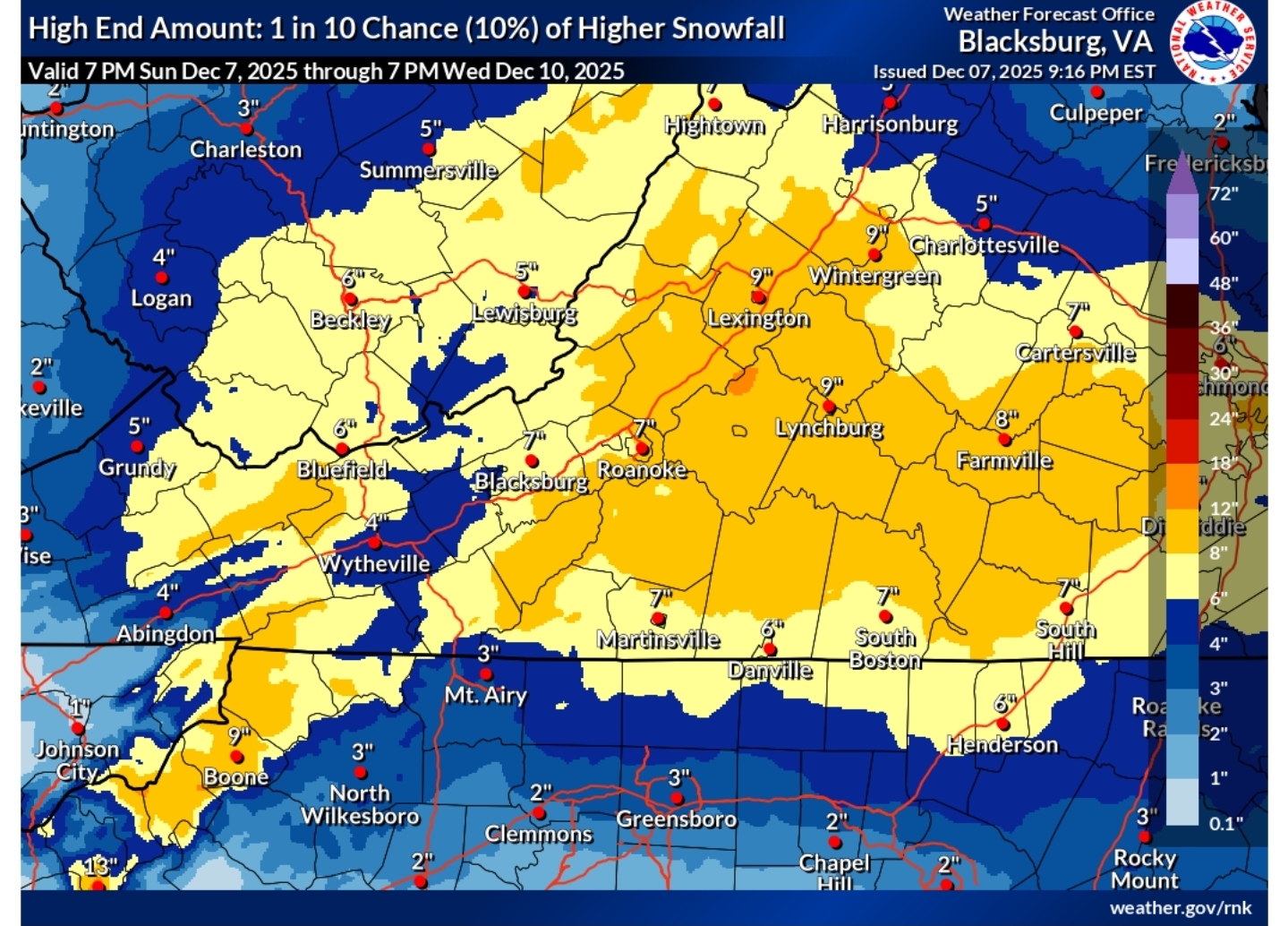
Highly unlikely to happen but a 10% chance it does. High bust potential either way with this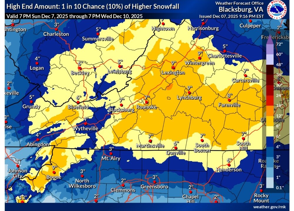
-

December 2025 regional war/obs/disco thread
Snowcrazed71 replied to Torch Tiger's topic in New England
So here's a hypothetical. Let's just say we get to the end of the month with less than 5 in of snow for all the areas that are still waiting for snow ( New York Long Island most of Connecticut, Southeastern Massachusetts and Rhode Island ). Are you going to stop coming on the forum and just give up. I think not, but I'm just wondering ( and let's hope this is worst case scenario ) -
The Monday wintry event potential (12/8/25)
BornAgain13 replied to GaWx's topic in Southeastern States
Looks nothing like the global though. All the global are south of the nam and hrrr. Just something to watch. Probably somewhere between the 2 is a good spot! -
The support for a warm up late month is this - implies a big storm in the Southwest gets stuck around Dec 21-25 in a Rex Block and floods the East with warmer air in that period. Probably doesn't last long. Then you revert back to canonical -WPO for a while. But, later on, six 6-10 days out, the same maps over NE Asia imply storms get cut off over the NM/AX/MX/TX borderlands either via weak subtropical impulses or lost waves from the Northern jet. If some of those eject east when it is cold, that's a better signal for the East for storms and cold, but that's very late in December, probably Dec 30 into week one of January. The deep blues over southern Kamchatka were last there late Oct to week one of Nov, when we had the three week stormier period in the Southwest from Nov 15-Dec 5 or so as the timing pretty much always works at a 17-21 day lead. Your call or not whether you believe it.
-
It might be with the Walker Circulation starts to strenghten,this is why you see the ensembles pull the JS much further north and basically traps the cold air up North in the long range in a NINA
-
The Monday wintry event potential (12/8/25)
BornAgain13 replied to GaWx's topic in Southeastern States
Still looks like we get a solid event up this way. Just to my north Advisorys have been upgraded to Warnings! Gonna be a nice narrow stripe of 4-6"+ somewhere -
32.2, if starts snowing in the morning I don't think we get above freezing.
-
Not a reprimand! Frankly, I just want the northern crew to sound like we are used to snow and brush these misses off like a dusting on the windshield. But, yea, I’m really jelly. December snow IS special.
-
Just got the WSW text for my yard. Welcome surprise. Lowest stress warning level storm I can remember. Never expected it and here it is 8 hours before onset lol. Awesome
-
28.5/27.2 at 9:30 here. Although I am one county off from the just issued WSW, I'll take whatever falls. The models have done nothing but increase snowfall with each run it seems.