All Activity
- Past hour
-
1.9” in Moncure
-
 Nice! Glad I turned the AC off and opened the windows before I left lol
 -
3.5 inches so far, finally a good rain
-

If you could re-experience ONE winter event....
sbnwx85 replied to cyclone77's topic in Lakes/Ohio Valley
I remember my mom telling me about water skiing and barbecuing at the lake on Christmas of ‘82. -

E PA/NJ/DE Summer 2026 Obs/Discussion
BBasile replied to PhiEaglesfan712's topic in Philadelphia Region
It's a drone. A DJI Mini. -
You have been here for one of the more interesting periods weather wise. Do not recall such intense thunderstorms on consecutive days like this in quite some time.
-
I do wonder if the low-level circulation is reforming further south near the mid-level circulation in Bertha.
-

2026-2027 Super El Nino
bluewave replied to Stormchaserchuck1's topic in Weather Forecasting and Discussion
An interesting question is why the recent 2023 developing super El Niño was able to break from the warmer 2020s -PDO/+AMO summer atmospheric mid-latitude pattern and this one in 2026 hasn’t so far? We’ll have to just wait and see how things go heading into the fall and winter. Since a lingering -PDO atmospheric pattern could potentially alter the state of the Aleutian low and possibly even where the maximum STJ precipitation zones set up. -
 That's gonna feel good after my 106 high and 84 low yesterday at AFW
 -

2026-2027 Super El Nino
snowman19 replied to Stormchaserchuck1's topic in Weather Forecasting and Discussion
As strong El Niño as it gets….. And the subsurface heat/DWKW is reloading and strengthening under the 30C warm pool and is going to get pushed to the South American coast in the next month by the DWKWs and WWBs. The thermocline depression is ridiculous -
Definitely. But the worst is likely behind us. August heat never feels as bad with the lowering sun angle at least in my opinion.
-
 His post makes me want HHH to come back asap. As much as I don't think that's going to happen in next couple weeks.
 -
HRRR looks a lot better for your area today. 2”+. Hope it works out - this event could go a long long way to breaking this drought for all of us.
-
 The point was. He posts every tweet from them about cold and below normal and leaves out anything related to heat, AN. It’s part of his agenda
 -
 At least he didn’t cancel summer on July 4th like last year.
 -

2026-2027 Super El Nino
40/70 Benchmark replied to Stormchaserchuck1's topic in Weather Forecasting and Discussion
Yes, but that doesn't render them worthless...rather it's incumbent on a quality seasonal forecaster to apply the necessary modifcations. -
Big points for the RRFS, or as I call it, Rufus. It had the I-40 corridor getting slammed for the Wed Eve-Thursday morning period first among the cams.
-
Thats a good chunk of time lost before any big heat comes back. That picture still looks like NW flow over New England. Isn't that guy from Indiana?
-

2026-2027 Super El Nino
SnoSki14 replied to Stormchaserchuck1's topic in Weather Forecasting and Discussion
We are also relying on analogs that might as well be from an ancient timeline. -
Just 1.21 here
-
2026-2027 Super El Nino
bluewave replied to Stormchaserchuck1's topic in Weather Forecasting and Discussion
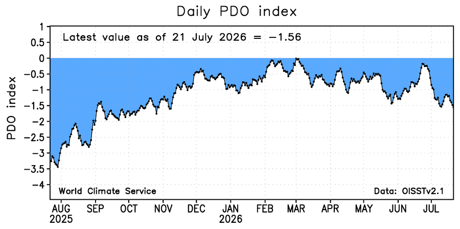
The -PDO/+AMO atmospheric pattern is the dominant player this summer so far across the CONUS.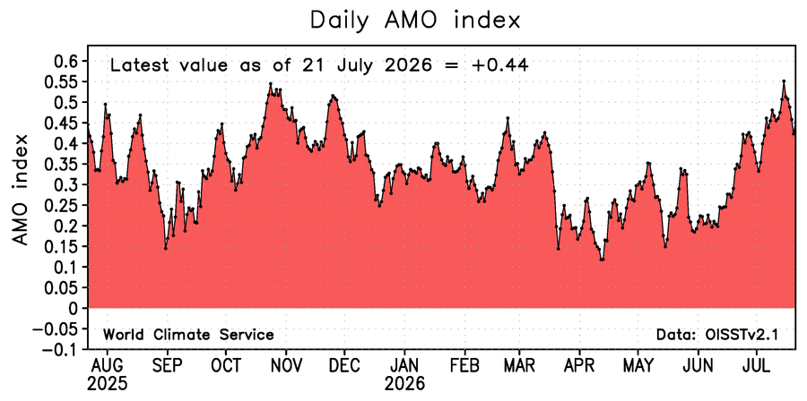
-
If you mean no more 100s then most likely but it's only July 23. Heat will likely return sometime in August
-
58 here. Nice morning.
-
 Nice down here this morning lows were around 60. AC is off today!
 -
August has been super kind to us the past few years. Let’s see if we can keep the streak going. I can almost smell football in the air.