
All Activity
- Past hour
-
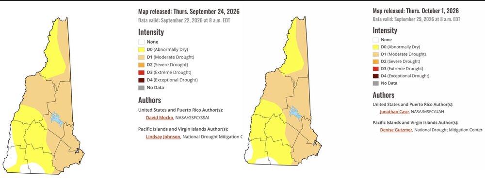
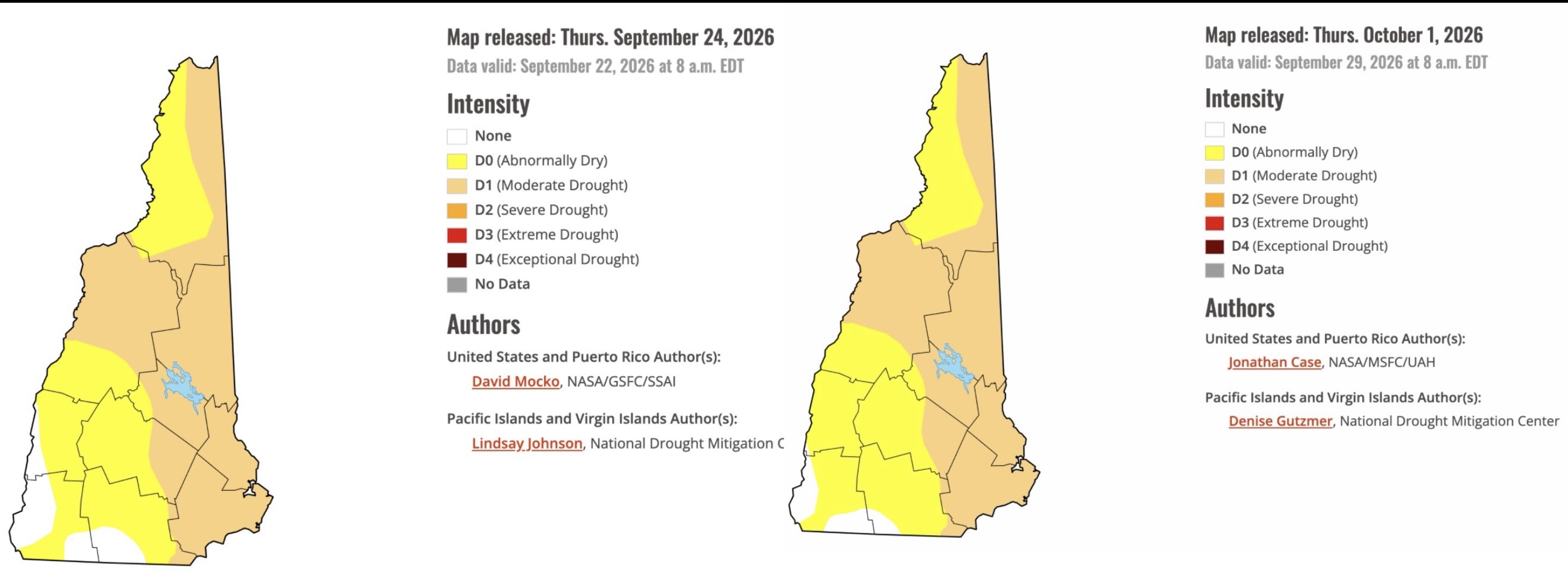
Drought monitor claims the recent rain had no impact in NH. My totals at home are: May 7.37” June 3.62” July 2.75” August 3.26” September 5.87” Total 22.87” Is just under two feet of rain low?
-
Where are people getting these sunny forecasts from these past few days? Was always going to be clouds rolling in
-
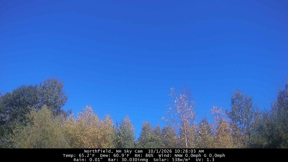
Still cloud free but will probably be BKN/OVC within an hour. Goodbye warm season. See you again on 12/24.
-
Can you find an underpass to get under?
-
All week forecasts have had partly / mostly sunny and all week has been mostly ass. Not specifically the Wrys and Crew , just in general.
-

Mountain West Discussion
donsutherland1 replied to mayjawintastawm's topic in Central/Western States
In part due to moisture from the remnants of Hurricane Polo, Lincoln, NE set an all-time daily precipitation record yesterday with 6.15" of rain. The old record had stood for more than a century.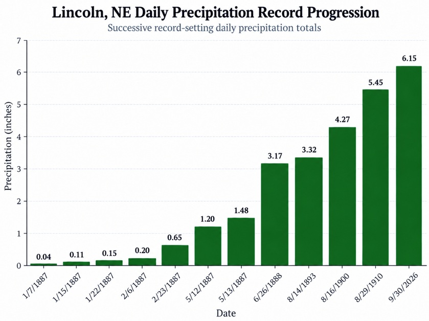
-
We had mostly cloudy for the day.
-
Yeah it really likes the overnight Friday Into Saturday rain. Kinda the only model showing that. Not even AI is as enthusiastic. Yeah it really led the way on the nor’easter.
-
If the Phils win tonight and advance it will ease my brain from the Birds lackluster performance and the Flyers getting throttled last night. If they lose, a total all around shitty sports week in Philly...utter failure.
-

2026 Atlantic Hurricane Season
WxWatcher007 replied to Stormchaserchuck1's topic in Tropical Headquarters
No hurricanes seems to be increasingly likely, but as for activity, the Gulf is starting to light up a bit on AI ensemble guidance. -
From the bottom of the barrel, the Icon ensembles.
.thumb.png.b60184f486e1f23a897b70716dcf3d4b.png)
-
we got the old unmanned fire hose across the continent. these guidance are flip flopping the jet and wave train because they're missing underpinning planetary wave signal. It's like all S/Ws and no L/W. without the L/W rail system, the S/W train slips off the tracks on ever model run.. heh
-

2026 Atlantic Hurricane Season
NorthHillsWx replied to Stormchaserchuck1's topic in Tropical Headquarters
As we are now in October and with absolutely nothing showing in any modeling, I am folding. For the first time this year I think the odds of not getting a hurricane exceed the odds of seeing a hurricane in the Atlantic basin. I'm going 60/40 odds (no hurricane/hurricane) at this point with only a CAG system as the realistic most likely chance to break the streak. Unbelievable -
Kind of surprised SPC doesn't have general thunder extending into the Northeast tomorrow
-
Radar looking like we may get trained on today. Ready 2 drown.
-
I know Ai was.
-
Has any one looked at the visible GOES-East this morning?
-
Wasn't the EuroAi and Eps combo the winning team over the weekend?
-
6z Eps
.thumb.png.5039d0d91a1009193ba0e58d42aea1e7.png)
-
I'm hesitant but I think I'll go with the Vikings. Miami is so bad and they lost their best player for the season.
-
October 1 1999: One of the earliest significant snowfalls in Minnesota history falls in a narrow track across southern Minnesota. Reported snowfall totals include 4.0 inches in Montgomery (Le Sueur County) and Northfield (Rice County), 3.8 inches in Springfield (Brown County), 3.0 inches in Vesta (Redwood county), and 2.8 inches in Mankato (Blue Earth County). 1989: High temperatures across central and southern Minnesota reach the 80's. Later in the day, a cold front would come through and drop the mercury to the 40's. For Thursday, October 1, 2026 1752 - The second severe hurricane in two weeks hit the Carolinas. The Onslow County Courthouse was destroyed along with all its records, and Beacon Island disappeared. (David Ludlum) 1893 - The second great hurricane of the 1893 season hit the Mississippi Delta Region drowning more than 1000 persons. (David Ludlum) 1987 - A blast of cold arctic air hit the north central U.S. An afternoon thunderstorm slickened the streets of Duluth MN with hail and snow, and later in the afternoon, strong northerly winds reached 70 mph. Unseasonably warm weather continued in the Pacific northwest. Afternoon highs of 90 degrees at Olympia WA, 92 degrees at Portland OR, and 89 degrees at Seattle WA, were records for the month of October. For Seattle WA it marked the twenty- first daily record high for the year, a record total in itself. (The National Weather Summary) 1988 - Afternoon and evening thunderstorms produced severe weather across central Oklahoma and the eastern half of Texas. Thunderstorms in Texas produced softball size hail northwest of Nocona, and baseball size hail at Troy and Park Springs. (The National Weather Summary) (Storm Data) 1989 - Thunderstorms produced severe weather in the southeastern U.S. through the daytime and evening hours. Severe thunderstorms spawned eleven tornadoes, with seven of those tornadoes in Georgia. A tornado southwest of Moultrie, GA, killed two persons and injured a dozen others. Tornadoes also injured one person north of Graceville, FL, and two persons at Bartow, GA. (Storm Data) (The National Weather Summary) Observances: 1 Thu International Coffee Day 1 Thu National Homemade Cookies Day 1 Thu National Fire Pup Day 1 Thu Urticaria day 1 Thu International Day of Older Persons 1 Thu National Hair Day 1 Thu World Vegetarian Day 1 Thu Breast Cancer Awareness Month 1 Thu International Music Day 1 Thu Balloons Around the World Day 1 Thu CD Player Day 1 Thu Model T Day 1 Thu National Black Dog Day 1 Thu National Lace Day 1 Thu National Raccoon Day 1 Thu Filipino American History Month
-
Raining in leominster
-
I’m not switching over until after Christmas Eve. Then it’s official.
-
Near-record highs today and tomorrow look to be replaced with actual fall next week. I hope these are the last 90's of the year, there is a good chance they are
-
100%. Great post, and info. Appreciate the explanations.








.png.43a87c4d8d5fa1690f9d61a95c52eb0c.png)





.png.188021931e6029587c3ba0f8b75c696c.png)





