All Activity
- Past hour
-
What the fuck is the euro and gfs smoking
-

80 Degrees to Ripping Snow: March 12th
MN Transplant replied to SnowenOutThere's topic in Mid Atlantic
Due to all of the snow on the roads, right? Right? And you don't go from 80s to 30s without everyone's favorite - wind! -
Gorgeous day out there. Mild, dry, bright sun. Take!
-
Tomorrow looks pretty meh. Maybe a little flip to snow as the dry air really begins advecting in. Mesos aren’t wild about it. Looks like a half inch at best east of the high terrain, but I wouldn’t be surprised if even that fails. Western upslope areas may get a sneaky few?
-
Going to be great to get some boomers tonight
-
Some of the model runs are uhh something for this area that's for sure. There is definitely a lot of moisture around to the S so I am not totally discounting higher totals. A late major snowstorm is a pretty typical thing around here in a transitioning Nino spring. With the recent notable examples of 4/13-15/18 and 3/25/23. However, being so warm ahead of said storm is unusual. Could be a very interesting start to next week here.
-
As Met pointed showed above, the GFS and now several short-range models are showing a deformation zone forming as the trough goes neutral and the cyclone begins occluding, wrapping moisture back into the colder air mass on the northwest side of the system. The window is very narrow, so odds are low, but it could surprise some folks with a burst of snow.
-
the models are trash, op’s and ens alike. tune in on saturday to see what will happen.
-

Occasional Thoughts on Climate Change
TheClimateChanger replied to donsutherland1's topic in Climate Change
-
front passed ewr and they jumped to 75. crazy for march
-
We'll see. Now it has heavy stuff moving through the metro after 9pm
-
Will likely see snow in the air but doubt much of that sticks given the warmth of the last 3 days
-
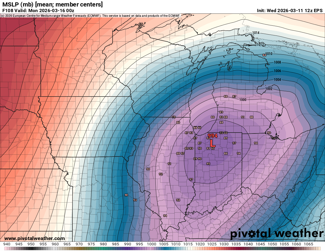
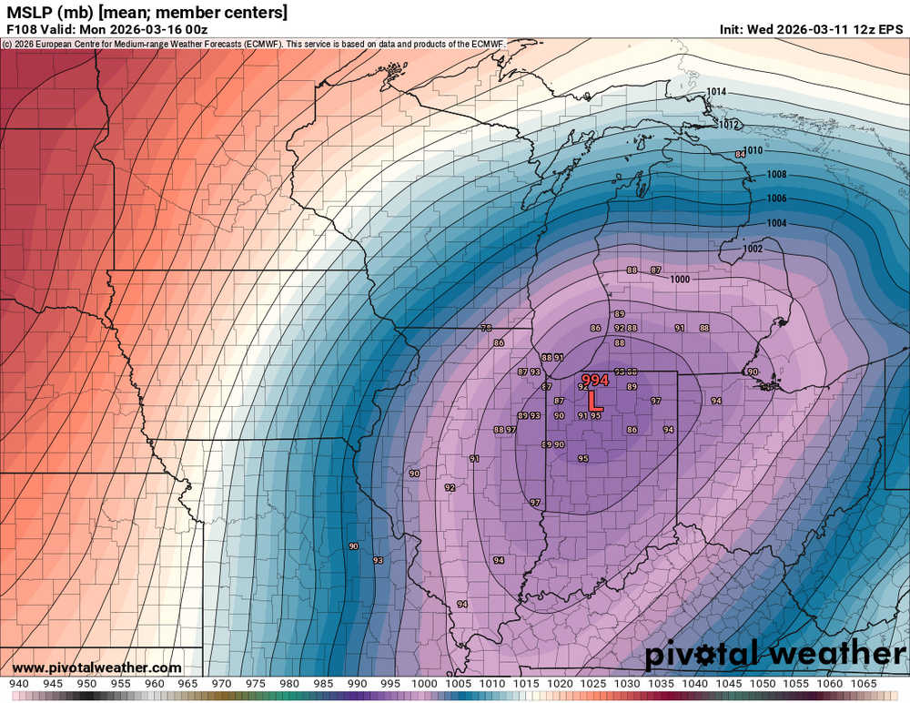
EURO has a light/mod event on the 25th. Obviously weeks out but perhaps not a shutout pattern through the end of the month.
-
Below normal in NE…all we care about. What a winter.
-
-
The National Weather Service disagrees. Here is the 2:00pm updated disco: “The cold front should move through early Thursday morning, so after a relatively mild Wednesday night with lows in the 40s, winds switch quickly to the NW as a continental polar air mass moves in. High temps in the 50s will likely be achieved in the morning, with temps falling into the 40s after fropa, and then to the upper 20s and 30s Thu night. Post-frontal rain showers could mix with or change to wet snow showers just before precip ends. Boundary temps will be noticeably milder than aloft, so any wet snowflakes will have difficulty accumulating. Liquid precipitation amounts are likely to range from 1/4 to 1/2 inch, with the higher amts from NYC north/west where stronger showers/thunderstorms are expected.” Forecast for Rockland County: “Thursday Rain showers before 2pm, then a chance of rain and snow showers. Temperature falling to around 40 by 9am. Northwest wind 13 to 15 mph, with gusts as high as 29 mph. Chance of precipitation is 80%. Little or no snow accumulation expected.”
-

80 Degrees to Ripping Snow: March 12th
NorthArlington101 replied to SnowenOutThere's topic in Mid Atlantic
I guess you'd expect they would - and I realize they are useless at this range, but EPS look exactly like the OP. Guess it's time to "prep" for a few inches of snow falling - not necessarily sticking -
I’ve found it’s usually sleet. I suppose it technically can report it in other scenarios, but I feel like you usually just see it defer to the alternate ptype when there’s a mix…or the dom type in a RS scenario. I’ve just seen it report S with a jump up in vis too many times when there’s ptype goes from straight S to an obvious SIP mix. Unfortunately ASOS is pretty bad with L/ZL detection.
-
Tomorrow lol.
-
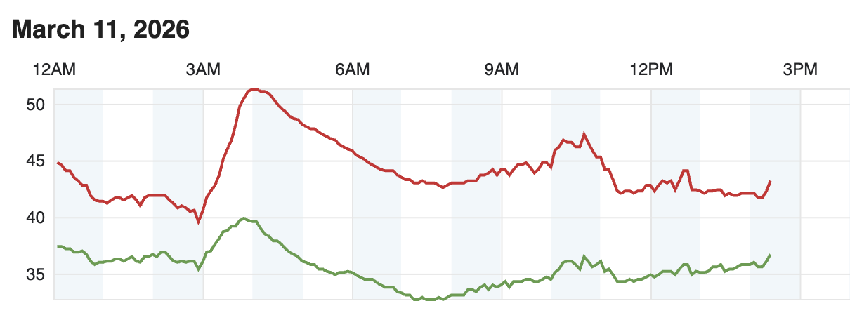
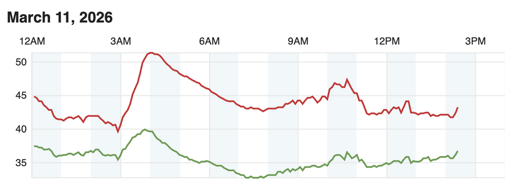
42 and cloudy all day long here. Vicious departure from yesterday.
-
EPS big shift South?
-
You can blindly forecast that without any models, and 75-80% of the time you'd be right. That's been a multi-year trend, and I can easily see most of our frontal passages and pop up thunderstorm forecasts resulting in exactly that for this season too. It's probably the reason drought conditions are generally worse as you get closer to the east coast (although for now not right on the coast).
-

80 Degrees to Ripping Snow: March 12th
SnowenOutThere replied to SnowenOutThere's topic in Mid Atlantic
In fairness I said “ripping snow” not accumulating snow. -
I just don't understand why people keep saying this is unreasonable. If you're looking at 10:1 maps of course it's unreasonable. But with the temperatures and when the snow is going to fall, why would you look at those maps?- even Kuchera will be wrong. Snow depth with the GFS and the 12 Z Euro shows a 1/2 to an inch of snow and maybe some lollies a tad higher. All on grass and any colder surfaces bc rates will be heavy according to the models.
-
Yep, can't wait for next January.