All Activity
- Past hour
-
.thumb.jpg.6a4895b2a43f87359e4e7d04a6fa0d14.jpg)
Central PA Spring 2026 Discussion/Obs Thread
Yardstickgozinya replied to Voyager's topic in Upstate New York/Pennsylvania
Sometimes I get really p***** off when I think about all the stuff I wrote as Flatheadsickness that got deleted. The crazy thing is you all can choose to believe this or not but this phenomenon has commonly been witnessed by cannabis growers including myself during lights out for years . I actually wrote about trees and Turgor movements right before thunderstorms which may or not be related to Coronae glow. Back when I wrote about it, I just didn't know the proper scientific term for changes in the leaf . I still witness turgor movements in tree foliage every single foliage season right before thunderstorms but no one else ever seemes the notice. Thunderstorms conjure ghostly coronae in treetops, observed outdoors for the first time The weak electric discharges may set off ultraviolet sparkles over large swaths of forest under storms, potentially impacting canopy health 23 February 2026 Coronae glow on the tips of spruce needles, induced by charged metal plates in a laboratory. These weak electric discharges subtly singe the tips of leaves and needles, and new observations indicate they may occur ubiquitously across treetops under thunderstorms. Credit: William Brune https://news.agu.org/press-release/thunderstorms-conjure-ghostly-coronae-in-treetops-observed-outdoors-for-the-first-time/ -
12z HRRR says my call is looking a bit bullish.
-
I’m trying to figure out how Ray had the same amount of pack as me before last night.
-
very windy outside a few times i was pushed back...
-
Must be some good weed in Texas lol. You da man, Jeb. Windy and seasonal. Beautiful
-
No BN signal in E US:
-
Sounds slanty compared to what Ray had.
-
1.1 in Methuen..
-
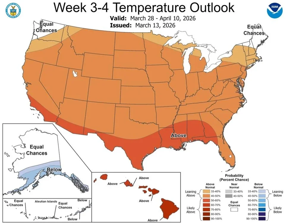
The map above was not accurately made. Examples: Providence and much of L.I. had 200+% of normal (pink), but this shows pink south of them. Bos is also too low. This has Charlotte ~normal vs actual of 300+%! It has GSO in NC in yellow vs actual of 200%!
-

Central PA Spring 2026 Discussion/Obs Thread
Voyager replied to Voyager's topic in Upstate New York/Pennsylvania
Well, it should make for an interesting video day if I encounter the storms in my travels. The only thing is having a brand new car with only 1,000 miles on the ticker. I'd be bummed bad if it got any hail damage. -
(002).thumb.png.6e3d9d46bca5fe41aab7a74871dd8af8.png)
Central PA Spring 2026 Discussion/Obs Thread
ChescoWx replied to Voyager's topic in Upstate New York/Pennsylvania
Continued breezy today and tomorrow with below normal temperatures not far from 50 degrees. We briefly warm on Monday with highs well into the 60's before a strong cold front crosses the area not too long after the evening rush hour. Rain chances to ramp up tomorrow night with over an inch possible by later Monday. We could see some severe weather Monday evening. With the cold frontal passage Monday night, we could again see rain changing to wet snow with temperatures dropping over 20 degrees over a couple of hours. Tuesday and Wednesday will be unseasonably cold with highs barely above freezing on Tuesday and remaining in the 30's on Wednesday.
-
E PA/NJ/DE Spring 2026 Obs/Discussion
ChescoWx replied to PhiEaglesfan712's topic in Philadelphia Region
Continued breezy today and tomorrow with below normal temperatures not far from 50 degrees. We briefly warm on Monday with highs well into the 60's before a strong cold front crosses the area not too long after the evening rush hour. Rain chances to ramp up tomorrow night with over an inch possible by later Monday. We could see some severe weather Monday evening. With the cold frontal passage Monday night, we could again see rain changing to wet snow with temperatures dropping over 20 degrees over a couple of hours. Tuesday and Wednesday will be unseasonably cold with highs barely above freezing on Tuesday and remaining in the 30's on Wednesday.

-
47 with sun. Not even going to talk about the W word although after a dust up to the morning there is a bit of calm now.
-
We're lucky for the recent precipitation, rough look for sure
-
.
-
soon to be all of us

-
6z EURO AIFS had a couple chances between 3/21-3/23.
-
-
Obviously, this is out at range, but this will happen either by the end of this month or in April. Blocking will form again because of the cycle we've seen so far. Sent from my SM-G998U using Tapatalk
.thumb.jpg.1f59b804745893417d3a415af8a7c27b.jpg)
-
Monday
-
Keep on blockin I ain’t shovelin
-

Central PA Spring 2026 Discussion/Obs Thread
Mount Joy Snowman replied to Voyager's topic in Upstate New York/Pennsylvania
Low of 34. Monday is really starting to get my attention. Going to alert some family later today after the 12z runs. Curious to see how the Mesos handle things over the next 24-36 hours. -

Pittsburgh/Western PA WINTER ‘25/‘26
EVLINC64 replied to Burghblizz's topic in Upstate New York/Pennsylvania
Power went off & on 6 times here & thankfully stayed on, But now I have neighbors patio furniture in my yard. Have very tall Choke Cherry trees behind my house too, But They all stayed up -
Finally a flood’s happen to me right in front if my face and my chicks can’t describe it?
-
Records: Highs: EWR: 79 (2007) NYC: 75 (1946) LGA: 75 (1946) JFK: 72 (2012) Lows: EWR: 17 (1993) NYC: 12 (1888) LGA: 18 (1993) JFK: 19 (1993) Historical: 1870 - The term blizzard was first applied to a storm which produced heavy snow and high winds in Minnesota and Iowa. (David Ludlum) 1933: A deadly tornado outbreak affected the Middle Tennessee region, including Nashville, on this day. The outbreak, which produced five or more tornadoes, killed 44 people and injured at least 461 others. The strongest tornado, F3, cut a path through the center of Nashville. About 1,400 homes were damaged or destroyed. Windows were blown out of the State Capitol Building. 1935: Suffocating dust storms frequently occurred in southeast Colorado between the 12th and the 25th of the month. Six people died, and many livestock starved or suffocated. Up to six feet of dust covered the ground. Schools were closed, and tenants deserted many rural homes. 1944 - A single storm brought a record 21.6 inches of snow to Salt Lake City UT. (The Weather Channel) 1960 - Northern Georgia was between snowstorms. Gainesville GA received 17 inches of snow during the month, and reported at least a trace of snow on the ground 22 days in March. Snow was on roofs in Hartwell GA from the 2nd to the 29th. (The Weather Channel) 1987 - A powerful storm in the western U.S. produced 15 inches of snow in the Lake Tahoe Basin of Nevada, and wind gusts to 50 mph at Las Vegas NV. Thunderstorms in the Sacramento Valley of California spawned a tornado which hit a turkey farm near Corning. (The National Weather Summary) (Storm Data) 1988 - Squalls in the Great Lakes Region continued to produce heavy snow in northwest Wisconsin and Upper Michigan, and produced up to 14 inches of snow in northeast Ohio. Poplar WI reported 27 inches of snow in two days. (The National Weather Summary) (Storm Data) 1989 - High winds in Colorado and Wyoming gusted above 120 mph at Horsetooth Heights CO. High winds in the Central Plains sharply reduced visibilities in blowing dust as far east as Kansas City MO. Winds gusting to 72 mph at Hill City KS reduced the visibility to a city block in blowing dust. Soil erosion in northwest Kansas damaged nearly five million acres of wheat. (The National Weather Summary) (Storm Data) 1990 - Fifty-three cities reported record high temperatures for the date as readings warmed into the 70s and 80s from the Gulf coast to the Great Lakes Region. Charleston WV was the hot spot in the nation with a record high of 89 degrees. It was the fourth of five consecutive days with record warm tempeatures for many cities in the eastern U.S. There were 283 daily record highs reported in the central and eastern U.S. during between the 11th and the 15th of March. (The National Weather Summary) 2007 - The temperature in Concord, NH, reaches a record high of 74 degrees less than one week after a record low temperature of 7 degrees below zero on March 8, an 81 degree temperature swing in six days. 2008: An EF2 tornado moved through downtown Atlanta, Georgia, shortly before 10 pm, damaging the Georgia Dome where the SEC men's basketball tournament was underway.


.jpg.927a60fbff36f3abec3b2a00524e3385.jpg)
