All Activity
- Past hour
-

July 2025 Discussion-OBS - seasonable summer variability
winterwx21 replied to wdrag's topic in New York City Metro
Most of us figured that HRRR was way off with the huge amounts for today. That model is very inconsistent, and it seems to be wrong more often than it's right. -
feels like we are getting an inordinate number of days so far with dews of 75F-80F. Not comfortable at all out.
-

July 2025 Discussion-OBS - seasonable summer variability
Brian5671 replied to wdrag's topic in New York City Metro
never buy into the "week of rain" hype. almost never happens this time of year -

July 2025 Obs/Disco ... possible historic month for heat
Damage In Tolland replied to Typhoon Tip's topic in New England
Similar to that Julorch 1 storm here last week -

July 2025 Obs/Disco ... possible historic month for heat
Snowedin replied to Typhoon Tip's topic in New England
Zeusinpowderville Too long? -

July 2025 Obs/Disco ... possible historic month for heat
CoastalWx replied to Typhoon Tip's topic in New England
Dews do that -

July 2025 Discussion-OBS - seasonable summer variability
jm1220 replied to wdrag's topic in New York City Metro
Which happens 9 out of 10 setups in the summer. -
95 was my high.
-
That is no joke. Hope you’re okay.
-
For some unknown reason my wife convinced me to go play pickelball at 5:30. Not my brightest moment.
-

July 2025 Discussion-OBS - seasonable summer variability
steve392 replied to wdrag's topic in New York City Metro
Everything dying out. So much for that training rain :/ -
0.80"
-

July 2025 Obs/Disco ... possible historic month for heat
powderfreak replied to Typhoon Tip's topic in New England
Ha, I don't think I've ever seen anything like this. Just seeing jagged lightning go to the ground, over and over and over right out the window. Sounds like WWIII. -

E PA/NJ/DE Summer 2025 Obs/Discussion
RedSky replied to Hurricane Agnes's topic in Philadelphia Region
How can a depression not agitate this soupy atmosphere into heavy rain Meanwhile the weakass front traversing the state looks wetter -
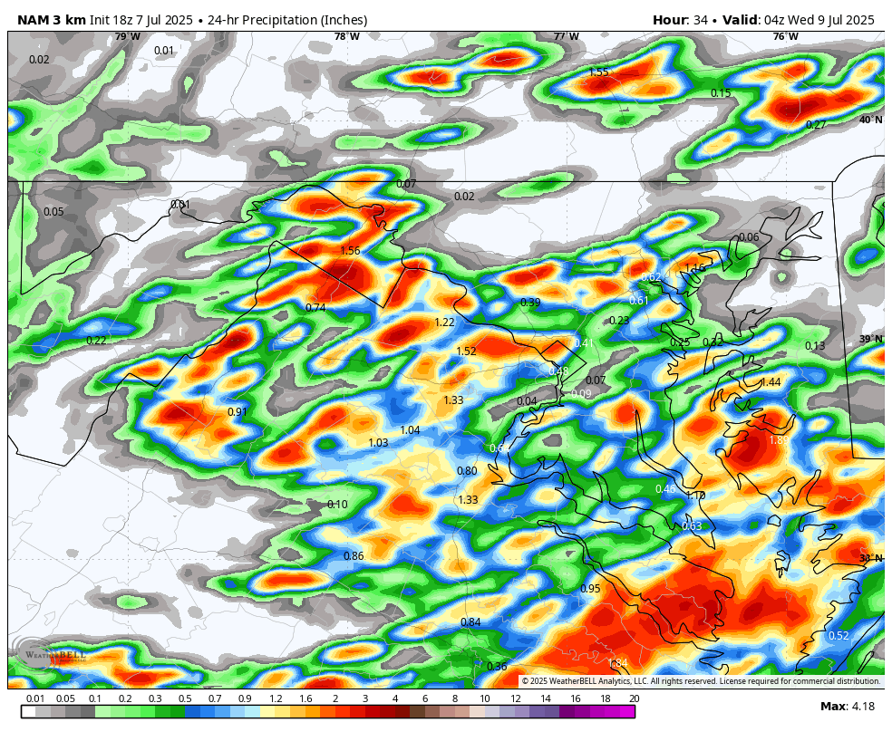
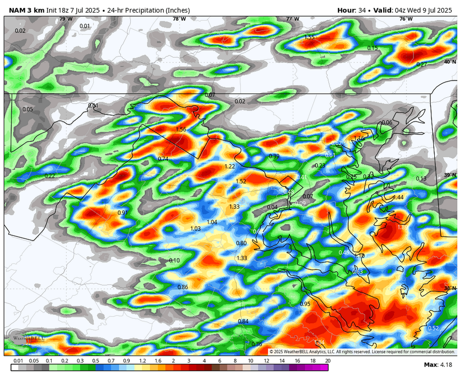
WB 18Z 3K NAM, hopefully more widespread chances for thunderstorms tomorrow west to east starting around 3pm.
-

July 2025 Obs/Disco ... possible historic month for heat
dendrite replied to Typhoon Tip's topic in New England
He’s been quiet today…must still be looking for a blue ptype pixel. -
July 2025 Obs/Disco ... possible historic month for heat
CoastalWx replied to Typhoon Tip's topic in New England
Powdewfreak -
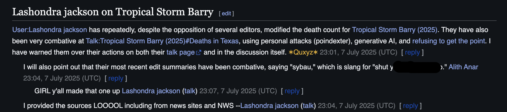
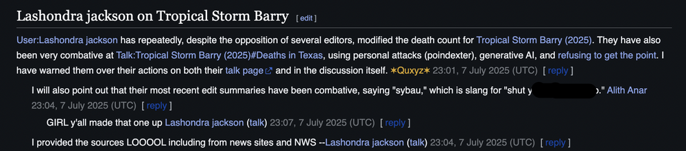
I think so Plus the editors are at war with someone saying that Barry killed 95 people See here, Lashondra posted legit sources (Papin, NWS, news sites) and the wiki editors are refusing to listen to her https://en.wikipedia.org/wiki/Talk:Tropical_Storm_Barry_(2025)
-
July 2025 Obs/Disco ... possible historic month for heat
powderfreak replied to Typhoon Tip's topic in New England
This is some of the craziest lightning in a while. Map has multiple strikes within a mile. Dog is going nuts. These are bright flashes followed by immediate chest thumping concussions. Closing in on 1" of rain too. 2.50"/hr rate. Zeus is just cranking bolts down into the center of Stowe.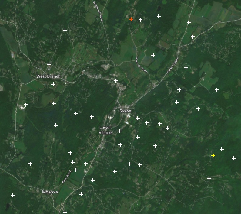
-
Bluesky increasing in popularity
-
Is there a chance that the name Barry will be retired as a result of the TX floods?
-
E PA/NJ/DE Summer 2025 Obs/Discussion
RedSky replied to Hurricane Agnes's topic in Philadelphia Region
The anemic models nailed it -
I think he’s commented before on why this pattern seems to be coming more common. But currently another bite at this Apple seems inbound for 25-26.
-
Who are “they” and what do “they” want me to think?
-

July 2025 Obs/Disco ... possible historic month for heat
WxWatcher007 replied to Typhoon Tip's topic in New England
I'm not fully sold, but tomorrow does seem like a day to watch in SNE. There could be some localized flash flood risk. Maybe higher end. Here was BOX and WPC this afternoon: BOX Models still indicate favorable ingredients for heavy rainfall. Broad anticylonic flow will advect high PWATs into the region. In some instances values will approach 2.5 inches. Values this high are around +2.5 STD above climatology and are certainly a significant signal for heavy rain. Unsurprisingly model soundings have also hinted at favorable conditions for localized flash flooding. The most notable signals include weak winds through the column, deep warm cloud depths, and tall skinny CAPE profiles. HREF ensembles have started highlighting areas in our CWA with 5-15% probabilites for 6 hour precipitation totals to locally exceeding the 100 year annual return interval. Not every area will see heavy rainfall tomorrow, but any storm that forms in this environment will be capable of producing rainfall rates of 1-2 inches per hour. Communities most at risk include poor drainage and urban areas with little in the way of permeable surfaces. WPC ...Mid-Atlantic and Northeast... Post-tropical cyclone Chantal will be exiting east of Cape Cod to start the period as it continues to get caught up in increasing southwesterlies downstream of a trough approaching from the Great Lakes. This trough will continue to translate eastward through the day, but will be slow to advect due to downstream Bermuda-type ridging. Between these two features, SW flow will remain prevalent over the area, with 850-500mb winds being nearly unidirectional from the W/SW at 15-20 kts. This will result in a continued extremely moist environment with PWs likely eclipsing 2" from eastern VA through southern New England Tuesday afternoon, coincident with a plume of SBCAPE exceeding 2000 J/kg. Into these impressive thermodynamics, a shortwave embedded within the mean flow will traverse northeast ahead of a cold front and along a surface trough, providing additional ascent atop the already impressive convergence on these boundaries. This suggests showers and thunderstorms will become widespread, which is additionally supported by high-res CAM simulated reflectivity. Storms that develop will move very slowly, and Corfidi vectors collapsed to just around 5 kts will support backbuilding and training echoes along the surface trough and front. With warm cloud depths potentially eclipsing 14,000 ft, this will support efficient warm-rain processes and rain rates above 2"/hr at times. Where training occurs, this could result in total rainfall in excess of 3", with instances of flash flooding possible across much of the I-95 corridor from Richmond, VA to Portland, ME, and a slight risk has been added for this area.