All Activity
- Past hour
-

December 2025 regional war/obs/disco thread
moneypitmike replied to Torch Tiger's topic in New England
LOL--KY with 2x more snow than PWM. I like the 50mph winds showing up on my new P/C for Friday. It might not snow there, but it will blow. -
If we have a slightly negative or neutral PNA that would drive a more zonal jet stream, it could work with a -NAO, but a sharply negative -PNA would drive such a deep trough on the west coast that the SE ridge would respond and possibly link with the NAO block. That’s obviously what we want to avoid.
-
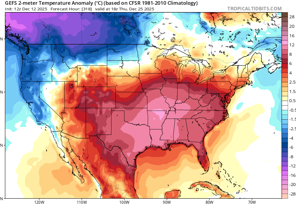
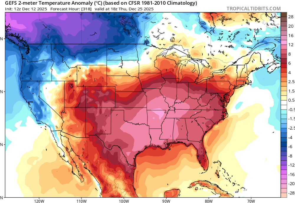
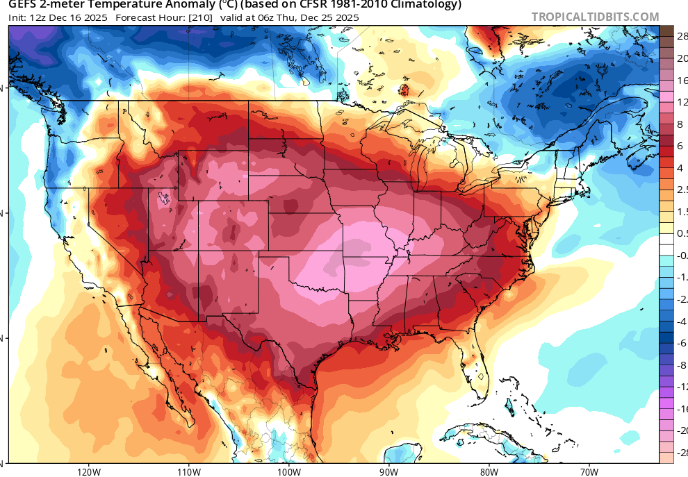
Took away our high pressure to the north for Xmas. But whatever…we’ll check back in once we’re inside a week. 12/23 wasn’t too far off from something decent either. Seems like the ridge axis was further east than other runs. Subtle but important differences. OP vs EPS
-
that would guarantee a couple of weeks of cutters too
-
Once the block hooks up with the southeast Ridge, like it’s been doing more often than not over the past few years that will keep most of the east US warm. The southeast Ridge is almost always under modeled so I’m not sure it’s a good look.
-

December 2025 regional war/obs/disco thread
WxWatcher007 replied to Torch Tiger's topic in New England
-
Euro AI offers hope. Haven’t seen EPS.
-
Christ euro is a disaster.
-
we could definitely get something around Christmas eve and on! Not so sure I like that look though!
-
Hopefully the PNA doesn’t tank negative, that’s what seems to drive it like what happened in 2023.
-
These overnight lows would be nearing records for warmth
.thumb.png.f750350a7c445cb2c835c82505930e29.png)
-
Very acceptable.
-

December 2025 regional war/obs/disco thread
WinterWolf replied to Torch Tiger's topic in New England
STFU…take your crap out of here. -
.thumb.png.a320f4d68754936e9f2360da174335c3.png)
-

Central PA Winter 25/26 Discussion and Obs
canderson replied to MAG5035's topic in Upstate New York/Pennsylvania
As Jimmy V, never give up. You’re proof! -
12z GFS has us in the 40s for Christmas.
-
MGJ : -7.1 HPN: -7.6 DXR: -7.0 You can look them up here: https://www.weather.gov/wrh/Climate?wfo=okx
-

Central PA Winter 25/26 Discussion and Obs
paweather replied to MAG5035's topic in Upstate New York/Pennsylvania
Thanks Canderson -

Winter 2025-26 Medium/Long Range Discussion
cyclone77 replied to michsnowfreak's topic in Lakes/Ohio Valley
It'd be nice to take advantage of the warmth and get some thunderstorm action but looks like the systems will be very wimpy the next 10-15 days. -
What about some of us up here like HPN, DXR and SWF?
-

Winter 2025-26 Medium/Long Range Discussion
A-L-E-K replied to michsnowfreak's topic in Lakes/Ohio Valley
-
I’m in wake county and have had temps in the teens and seen snow fall twice and it’s only the 16th of December. I’m content. .
-
wut.
-
Yard measurements were all 4.5-5", shaded driveway was spot-on 4", and elevated surfaces were 4-4.5. Due to my completely unorthodox procedures I'd call it 4".
-

December 2025 Short/Medium Range Forecast Thread
Carvers Gap replied to John1122's topic in Tennessee Valley
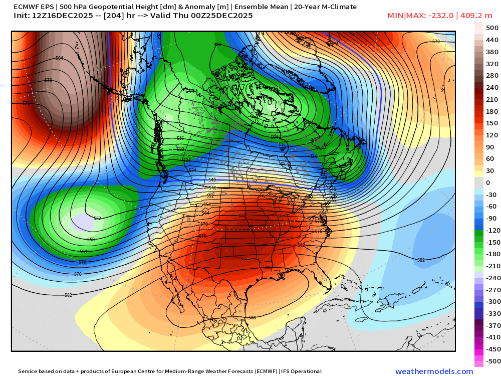
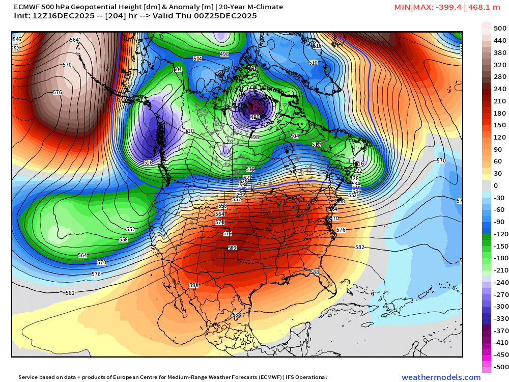
The 12z AIFS pushes back pretty heavily on the chinook - even more so than the 6z GFS. Take one look at the 500 map, and it doesn't look great. But take a look at what is creeping into Greenland. That is a game changer if it stands(and doesn't connect to a WAR). But take a look at the surface. Not what you would expect. That isn't warm. Cold air is seeping into the EC. A cold hp over the GL is not a bad thing for us. FWIW, the 12z GFS looked ready to break the chinook look by the end of its run. The NAO firing will force everything south.


.png.ccdc33952ce445c42642b31571c88464.png)


.png.970399f7e080763b61af92820eb9aaf1.png)