All Activity
- Past hour
-
She only looks petrified, she's actually frozen stiff.
-
I haven’t moved the rain magnet from my old house yet, so congrats SOMD
-
in NYC? Its happened in EWR - NJ. Ill have to check
-
That’s a pretty classic last four or more winter events kinda precip shield for our area - just hilarious watching the moisture hit a wall around Baltimore City and not advance north at all
-
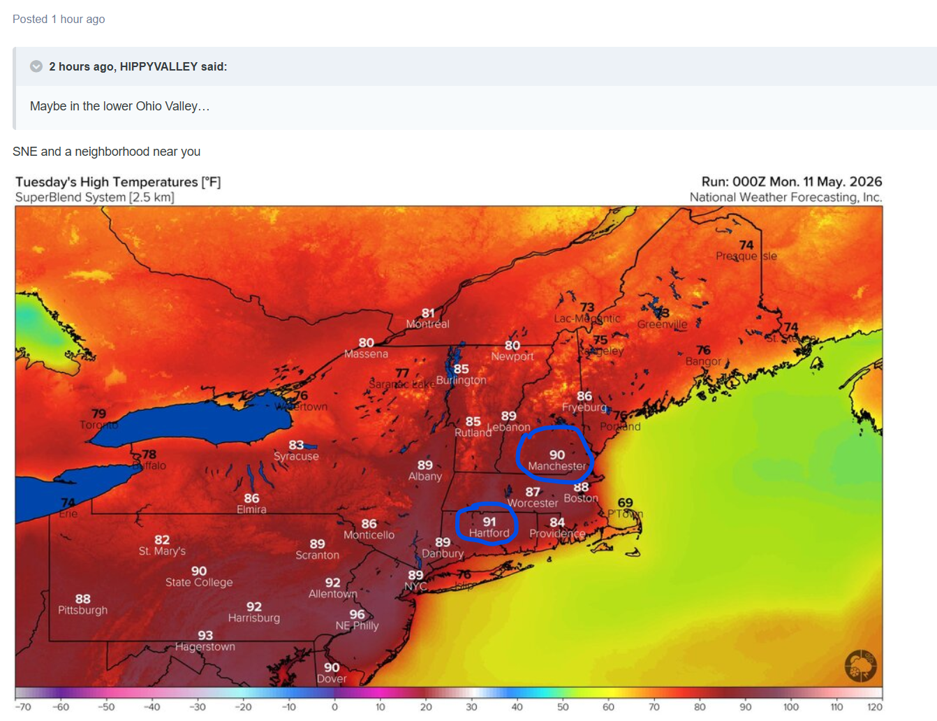
If we get a 90-degree day in May, this spring would be the first ever to get an 80 in March, and a 90 in both April and May, correct?
-
0.16 so far which is the most I've had for weeks. Hoping for more from that batch in central VA. You're right about it looking heavier on radar that is actually is. Yellows on radar just produce light rain. But I'll take it! Glad it held off for Mothers' Day
-
Ridging building in 5.17 - beyond next shot at 90s 5/17 - 5/24 - beyond
-
SST Anomaly
-
It's been a steady moderate rain here all morning. It looks heavier on radar than it actually is. There's probably some big wet snowflakes aloft.
-
Hm Not sure that you do ( bold ^), because your ensemble of reply is overbearing, out of line, and looks petty - seriously ...why in the fuck are you bolding text that was completely in jest. He knows that.... chill out and go away Besides ... those are outliers. They don't represent the intent and spin of his typical attempt at overselling - so ...I'm just bustin his balls Hopefully, you are sufficiently offended now.
-
0.02” today for a 0.11” two day total lol
-
Absolutely a nice weather morning we are having down here.... Much needed steady rainfall.... My first measurable rainfall in weeks...
-
Your wife is probably petrified.
-
Sprinkles earlier but rain missed us again, this time to the north
-
Wednesday would be a lot more interesting if low level winds were going to back. NW flow with modest dewpoints could give some nice, sculpted updrafts though. Wed might be decent for photography. Then early next week we'll see if we can get a system into the Mid-South. Current forecasts have it weakening as it moves out of the Plains into the Midwest. Just scattered showers for the Mid-South.
-
It has been a good spring for backdoor cold front enthusiasts
-
The radar right now reminds me of the January 3rd storm from 2022 with a front shutting off moisture flow to the north.
-
Worried about another frost/freeze the next two nights. It’ll be close.
-
Same here, was 53.5 at 7 am, now 47.6/46.8 at 10:30 am with rain continuing. Up to 0.40" in gauge since 7 am and a 0.88" total.
- Today
-
I’d say we’re definitely behind leaf out wise here. Kind of sad we’ve been rotting mostly in the 50s for weeks. Even yesterday was nice but struggled to upper 60s
-
Look, now I'm 100% for logic and bustin' people chops when they deserve it, but really John??? 90+ is pretty damn clear in this image. Who's gaslighting whom here?

-
Man that's a weird temperature distribution. Seems like you have a pretty scattered low level inversion considering the valleys are colder than the mountains?
-
An over-performer at last!!! Have received .60" since 6 am!! Temp. has dropped from 55 at 5 am to 43 at 9:55 am.
-
Models showing a pretty rainy Wednesday Thursday period. Let's see if it holds or fizzles
-
Yeah I noticed some TCU as well. Bit of humidity in the air so some instability certainly there.