All Activity
- Past hour
-
Records: Highs: EWR: 95 (2023) NYC: 94 (1985) LGA: 93 (1985) JFK: 94 (1961) Lows: EWR: 53 (2000) NYC: 51 (1963) LGA: 54 (2000) JFK: 52 (1989) Historical: 1925 - The temperature at Centerville, AL, soars to 112 degrees to establish a state record. Every reporting station in Alabama was 100 degrees or above that afternoon. (The Weather Channel) 1929: Early season snowfall occurred in the mountains of Wyoming and the Black Hills of South Dakota on September 5th and 6th. The highest snowfall amount was 16 inches in Fox Park, Wyoming. 1933 - A hurricane hit Brownsville, TX, killing forty persons and causing 12 million dollars damage. (David Ludlum) 1933: A Category 3 hurricane made landfall on South Padre Island, Texas during the late evening hours on September 4th, or Labor Day. The storm caused 40 fatalities and nearly $17 million in damages. With the storm making landfall during a holiday weekend, fatalities could have been much higher. The following is from the report of the official in charge at Corpus Christi, Texas: "Probably never before in the history of Texas hurricanes have such widespread and early warnings been given as were received from Washington in advance of this one. The telegram of Saturday, September 2, warning all persons to avoid inaccessible places over the weekend probably saved thousands of lives." 1950 - Hurricane Easy produced the greatest 24 hour rainfall in U.S. weather records. The hurricane deluged Yankeetown, on the upper west coast of Florida, with 38.7 inches of rain. (David Ludlum) 1950: Hurricane Easy was an erratic and unpredictable hurricane that lingered over the Tampa Bay area for days, dropping torrential rains and causing damage especially in Cedar Key, Florida where the storm eventually made landfall. This hurricane dumped 38.7 inches of rain in 24 hours in Yankeetown, a record for the U.S. at the time, and caused $3.3 million in damage. Total rainfall amounts in Yankeetown was 45.20 inches. 1975 - Strong winds reduced visibilities to near zero in blowing dust resulting in a 22-car chain reaction accident on Interstate 10 near Toltec AZ. Two persons were killed, and 14 others were injured. (The Weather Channel) 1978: Tropical Depression Norman became the most recent tropical system to make landfall in California near Long Beach as an extra-tropical storm. 1987 - Thunderstorms over the Southern and Middle Atlantic Coast States drenched Charleston, SC, with 5.50 inches of rain, and a total of 13.50 inches in two days, flooding homes, and leaving roads and bridges under water. (The National Weather Summary) A tropical storm which formed off the South Atlantic coast was responsible for torrential rains over coastal regions of South Carolina. Between the 30th of August and the 8th of September, Charleston SC received 18.44 inches of rain. The heavy rains caused extensive flooding around the city of Charleston, seriously damaged cotton crops in the eastern part of the state, and resulted in an unusually high number of mosquitos. (Storm Data) 1988 - Five days of heavy rain commenced in west central Florida. Up to 20 inches of rain in four days resulted in extensive urban flooding, and evacuation of 1000 homes. Flooding claimed four lives, and caused more than five million dollars proprty damage. (The National Weather Summary)(Storm Data) 1989 - Thunderstorms produced six to ten inches of rain in south central Kansas between 6 AM and Noon. Serious flooding was reported around Wichita, with water four feet deep along some roads. A cold front crossing the Northern High Plains Region produced wind gusts to 63 mph at Sheridan WY. (Storm Data) (The National Weather Summary) 1996: Hurricane Fran made landfall near the tip of Cape Fear, North Carolina with maximum sustained winds near 115 mph on the evening of September 5th. Fran was responsible for 26 deaths and was at the time the most expensive natural disaster ever in North Carolina’s history. 2017: Hurricane Irma became a category 5 hurricane with maximum sustained winds of 180 mph. This made Irma one of strongest hurricane ever observed in the open Atlantic Ocean.
-

2026-2027 Record-breaking El Nino
EasternLI replied to Stormchaserchuck1's topic in Weather Forecasting and Discussion
Yeah, next big WWB just getting underway now. -
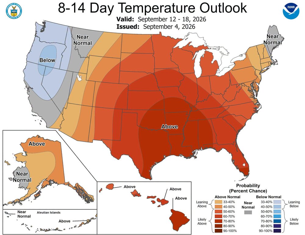
75 / 61 mostly sunny. Looking like a great day in this long weekend. Upper 70s low 80s. More onshore NE flow tomorrow could see more clouds and isolated showers in eastern areas i am still not totally buying the mostly sunny and dry forecasts especially eastern. Labor day looks like a copy of today upper 70s low 80s. Overall near to slightly above normal week with the 10th being the warmest day of the next 7 mid upper 80s or higher in the hot spots. Looking overall dry this week outside of some showers later on thursday. Beyond there overall near normal to above throuuh mid month. Ridge looks to build back into the mid section we'll have to see the extent of the eastern and northern influences. .
-
Guess that answers it
-

Septorcher 2026 Discussion - Endless Summer
tamarack replied to Damage In Tolland's topic in New England
Southwest Harbor (Penobscot Bay) recorded a gust of 115 mph in that storm. The 957 mb reading at CAR that day is a contender for lowest pressure in New England from a non-tropical storm. At Fort Kent we had 1.5" of rain plus 0.5" flurries with wind gusting to 50 and temp 46/-11. At 1 PM it was 44, 4 PM 14, 6 PM -6. By the next day the ice holes on most roads were awesome. -
Maybe @Weather Will can post some of the monthly maps when he gets a chance.
-
My yard is already rock hard and cracked. The .34 that i received over the past 7 days didn't do much for the drought. No rain in sight is great for my business but not for the drought. The creeks that feed the South River are mostly completely dry. We can't shake this drought.
-
Well done lol.
-

2026-2027 Record-breaking El Nino
forkyfork replied to Stormchaserchuck1's topic in Weather Forecasting and Discussion
-

Septorcher 2026 Discussion - Endless Summer
jlauderdal replied to Damage In Tolland's topic in New England
Coldest air temp I ever experienced was in Stowe -29F. -

2026-2027 Record-breaking El Nino
mitchnick replied to Stormchaserchuck1's topic in Weather Forecasting and Discussion
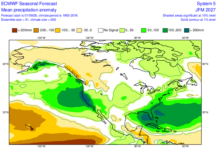
For coastal locations, it'll be harder for snow, but it'll still be dependent on exact track and surface High locations. But if the precip forecasts from all the seasonal modeling are correct, there will at least be a lot of chances. If nothing else, it won't be a boring winter. -
Not ideal
-

2026-2027 Record-breaking El Nino
SnoSki14 replied to Stormchaserchuck1's topic in Weather Forecasting and Discussion
Looks warm/wet like many have said. Probably under 10" snows in the NYC metro. Very 97-98 like -

2026-2027 Record-breaking El Nino
OSUmetstud replied to Stormchaserchuck1's topic in Weather Forecasting and Discussion
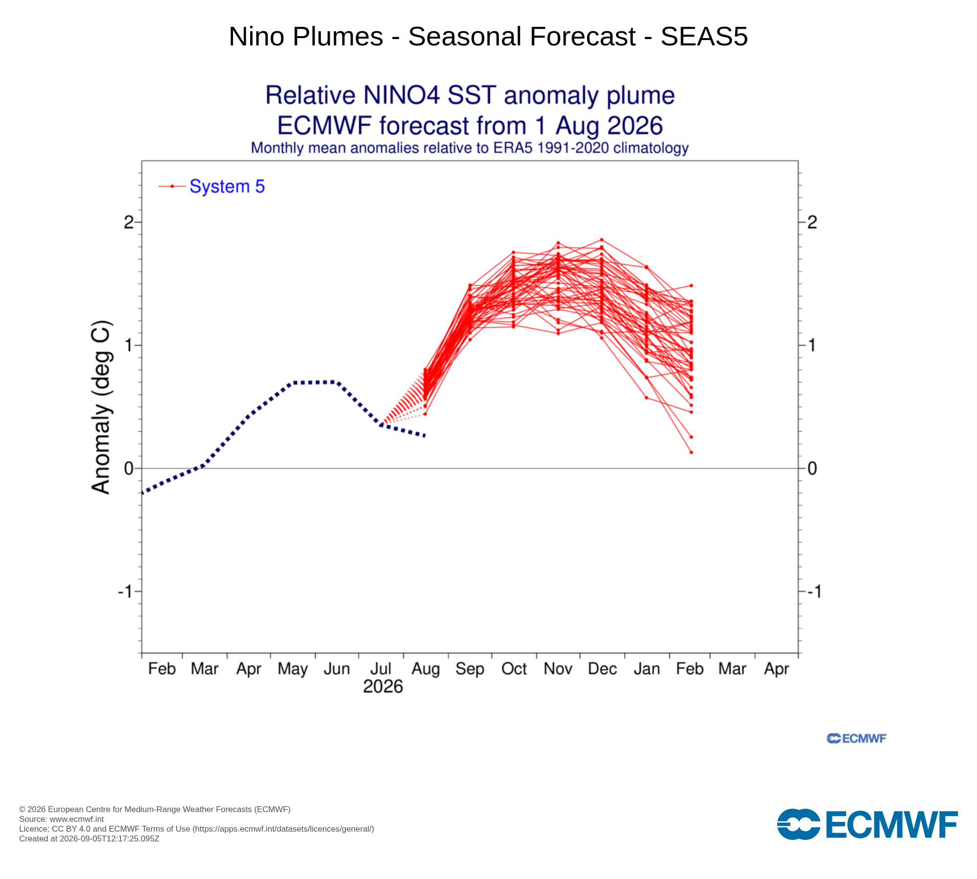
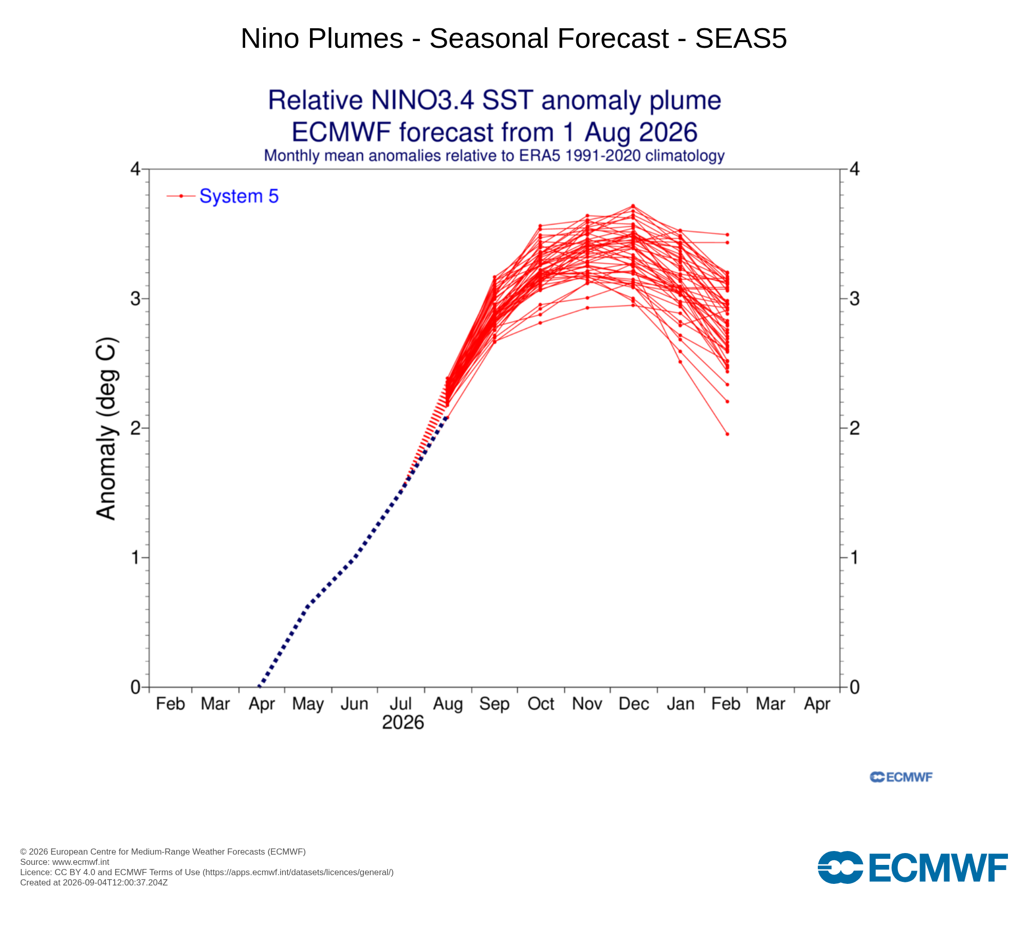
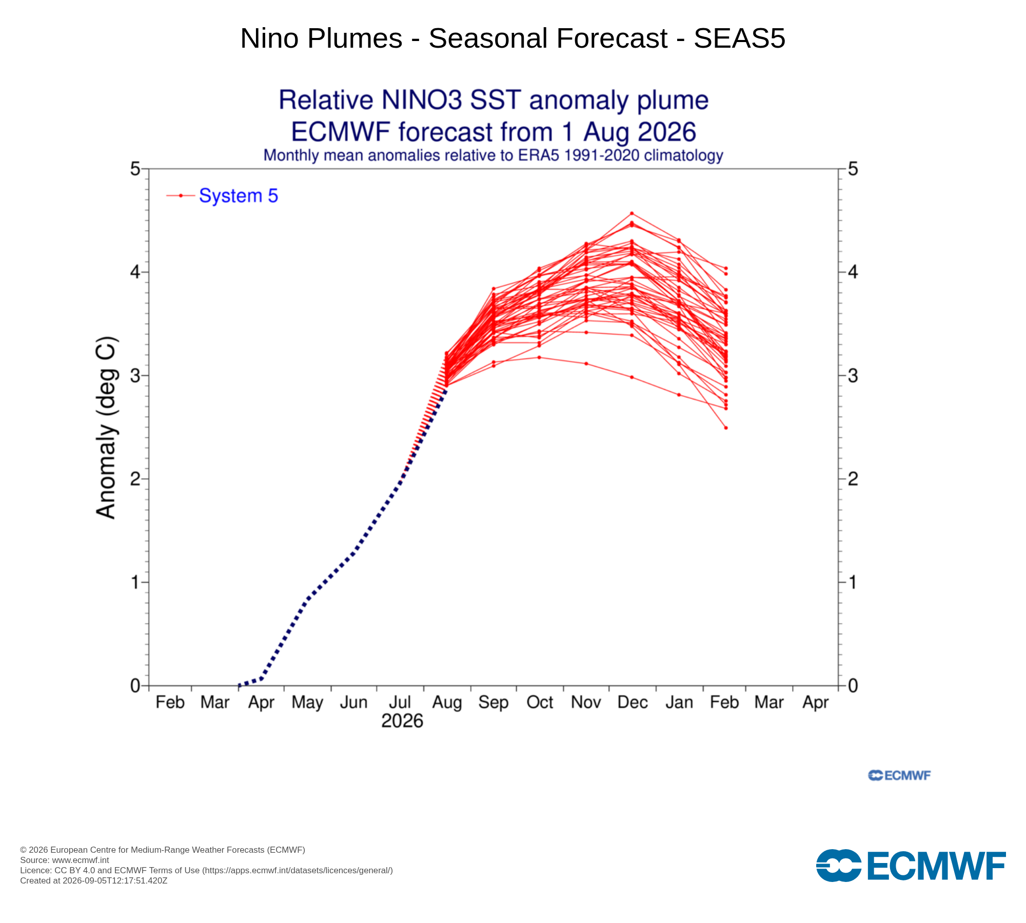
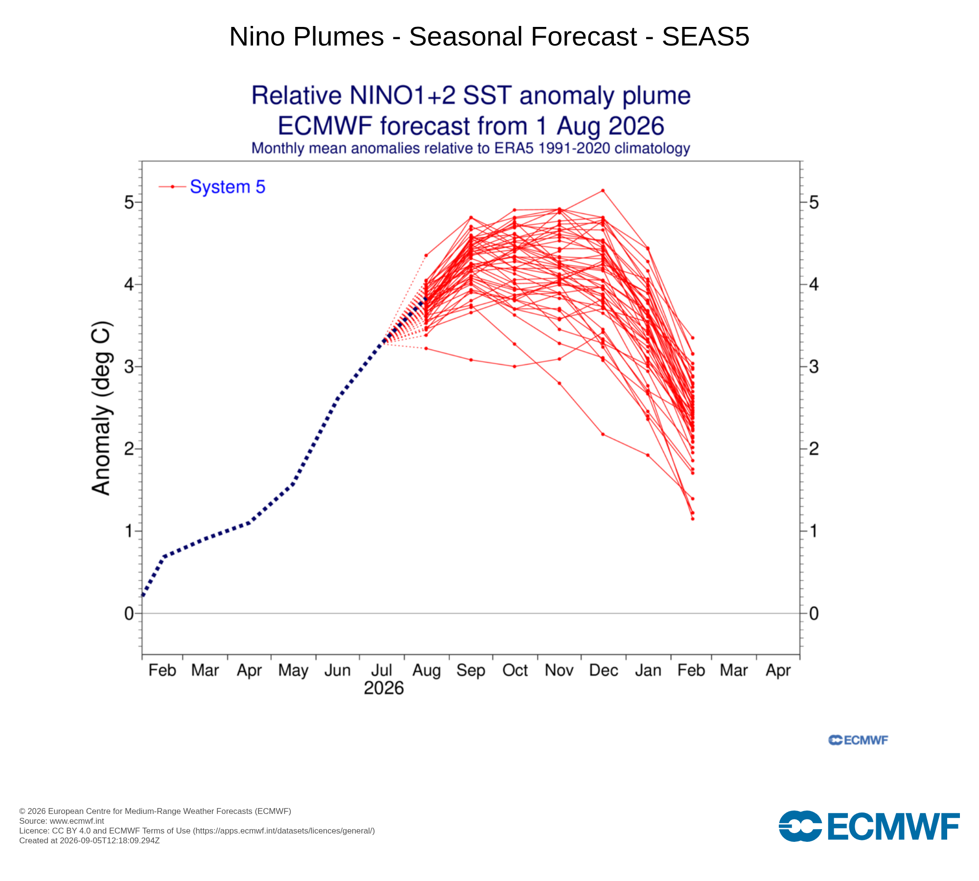
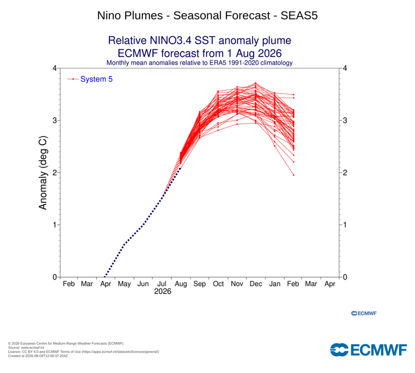
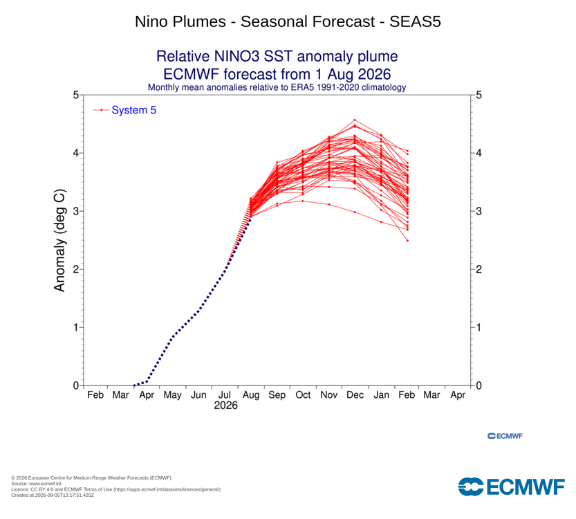
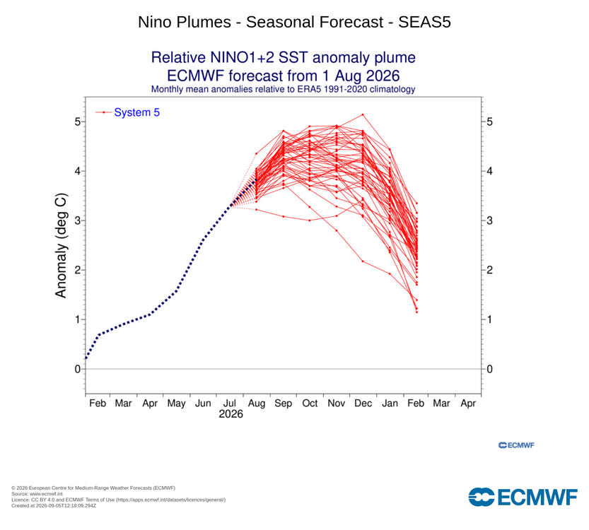
Nino 1+2 end up on the higher side of the average. The decreasing warm anomaly in Nino 4 was a big miss...falling completely outside of the ensemble spread. The forecasts for both Nino 3 and Nino 3.4 were near the bottom of guidance. RONI makes a difference but the sst analysis/database matters a lot too. ERA5/OSTIA puts the Nino 3.4 RONI around 2.1C whereas NOAA ERSSTv6 puts it at 1.7C. This is due to both very high resolution (0.05 degrees) and the inclusions of satellite-based SST analysis. The best forecasts from ECMWF from today and CPC/IRI plumes from late August still show this as a clearly record breaking Nino event with a RONI peak between 3 and 3.5C.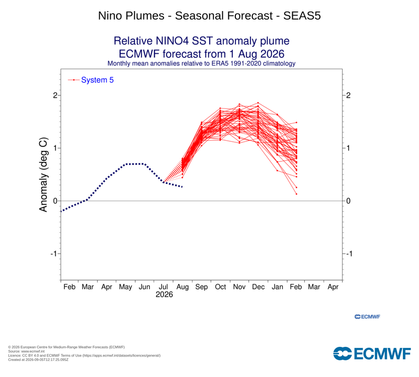
-
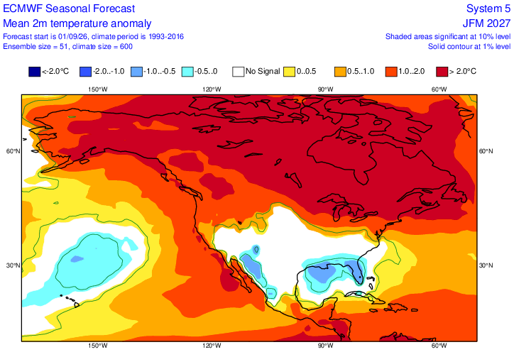
Updated Euro seasonal. A touch warmer for the winter months by around .5C. Still wet. Link to everything off this run. https://charts.ecmwf.int/?facets={"Product type"%3A["Experimental%3A AIFS"]%2C"Parameters"%3A[]%2C"Type"%3A[]%2C"Range"%3A["Seasonal"]}
- Today
-
2026-2027 Record-breaking El Nino
mitchnick replied to Stormchaserchuck1's topic in Weather Forecasting and Discussion
Link for everything on Euro seasonal https://charts.ecmwf.int/?facets={"Product type"%3A["Experimental%3A AIFS"]%2C"Parameters"%3A[]%2C"Type"%3A[]%2C"Range"%3A["Seasonal"]} -
2026-2027 Record-breaking El Nino
mitchnick replied to Stormchaserchuck1's topic in Weather Forecasting and Discussion
Precip DJF & JFM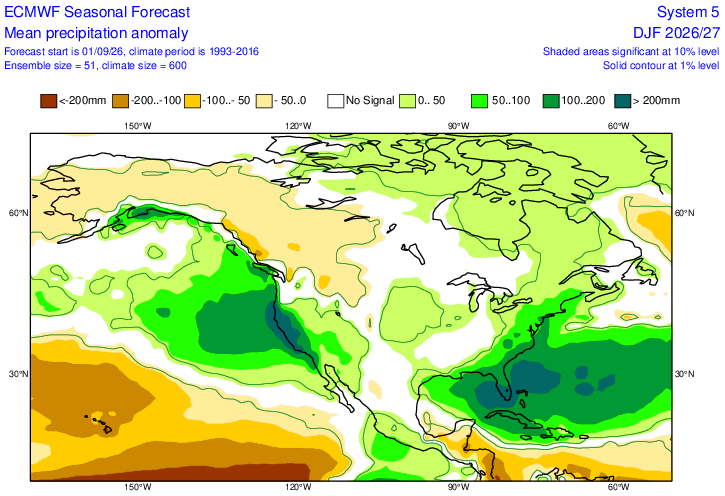
-
2026-2027 Record-breaking El Nino
mitchnick replied to Stormchaserchuck1's topic in Weather Forecasting and Discussion
850 DJF & JFM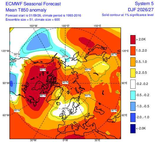
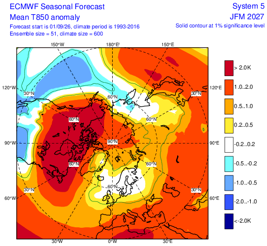
-
2026-2027 Record-breaking El Nino
mitchnick replied to Stormchaserchuck1's topic in Weather Forecasting and Discussion
H5 DJF & JFM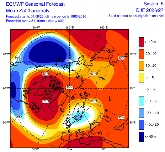
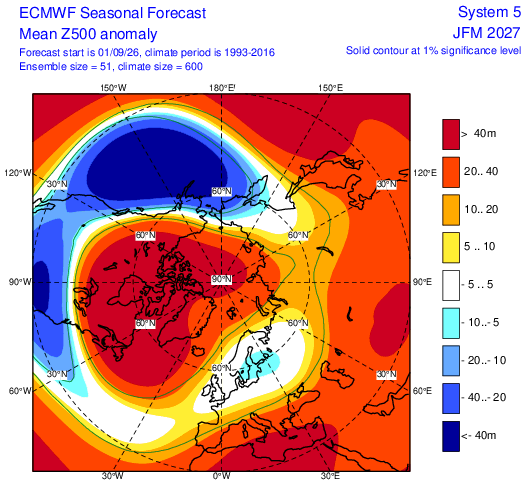
-
2026-2027 Record-breaking El Nino
mitchnick replied to Stormchaserchuck1's topic in Weather Forecasting and Discussion
Updated Euro a touch warmer this run. DJF and JFM T2.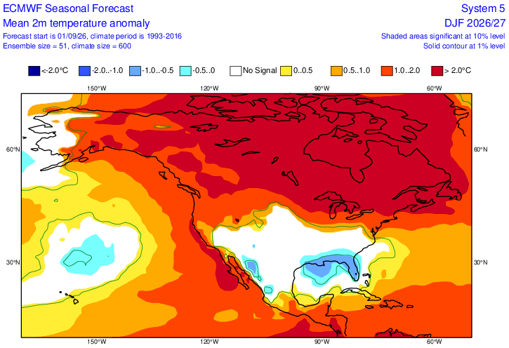
-
 https://nolvacare.com/# tamoxifen vs clomid
 -
what is tamoxifen used for: NolvaCare :: tamoxifen and osteoporosis
-
.thumb.jpg.6a4895b2a43f87359e4e7d04a6fa0d14.jpg)
Central PA Summer 2026 Discussion/Obs Thread
Yardstickgozinya replied to Voyager's topic in Upstate New York/Pennsylvania
What is the deal with tornadoes? You spend your whole life building a house, putting up drywall, picking out a nice neutral beige paint, and then the air decides it just wants to spin really fast and carry your sofa into the next county. And the meteorologists! They get on TV with their little glowing screens, pointing at red blobs like they’re tracking a hostile alien invasion. "We have rotation! Seek shelter immediately!" Calm down, Gary! It’s just wind having a nervous breakdown. Why does it gotta touch the ground? Stay up in the clouds where you belong! It’s like nature is doing a magic trick, but instead of pulling a rabbit out of a hat, it pulls your garage off the foundation and deposits it neatly in a cornfield. And what do they tell you to do? "Go to the basement." Oh, the basement! Right under the house that’s currently disintegrating. That’ll make me feel safe, sitting in a damp concrete box next to a water heater and a half-empty can of wood stain, waiting to see if my toaster ends up in Ohio.
-
Central PA Summer 2026 Discussion/Obs Thread
Yardstickgozinya replied to Voyager's topic in Upstate New York/Pennsylvania
I never ended up under a core, in fact, I didn't even really get that much rain from the event compare to others. However, the anvils alone provided the occasional close lightning strike . Distant flashes and thunder were continuous. Nights like those turn out to be very productive for me becaus It gives me a reason to keep my butt outside and work around the house. -
https://www.popville.com/2026/09/more-cars-smashed-by-downed-trees-from-last-nights-storm/ DC really got hammered by the Thursday night storm. Great photos in that thread with many downed trees. Our friends friends from NE DC stayed with us last night because their power was still out, though we think it's back now. There were no wind issues like this just a few miles north in silver spring, just heavy rain.