All Activity
- Past hour
-
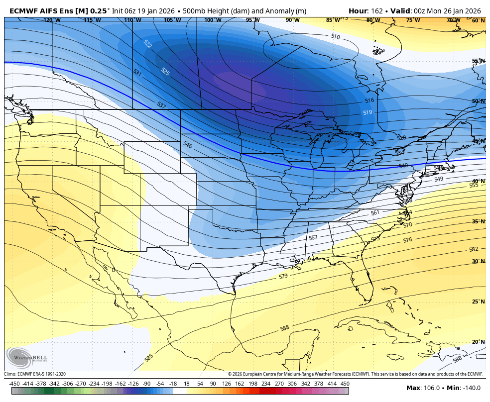
For this to really to go bonkers you’d want the through to close off over the Tennessee Valley. Even so, there will be an insane amount of overrunning precip.
-

-
Low of 27 with heavy frost.
-
-

Rise of the Machines: January 18-19 Winter Storm Obs Thread
vortex95 replied to WxWatcher007's topic in New England
That's a new modifier concerning snowfall -- "violently" beautiful??? Now everyone knows why I call CoastalWx the super UBER snow weenie! He makes up phrases to describe his ecstasy! -
We've seen the last minute rug pulled out from us MANY times. Honestly, just enjoying having something to track within 4 days at the moment.
-

Central PA Winter 25/26 Discussion and Obs
pasnownut replied to MAG5035's topic in Upstate New York/Pennsylvania
Yeah based on 500mb flow, safe or too safe is more likely for this one. I 80 souther special in the makings with northers still getting warning level. Only about 19 more model runs to go....lol -
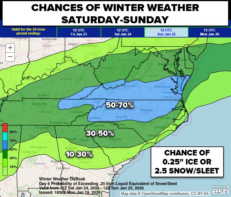
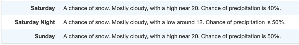
I know it's a silly point forecast but how often to we have that high POPs this far out plus highs barely out of the teens. Gotta be a strong signal.
-
I worked with Tomer when he was DTB at WPC…this is incredible coming from him…..but he’s not wrong imo. Do I think it’ll be the same magnitude? Probably not, but impactful to a point of major impact potential? Yes, it really could be. This is a pattern where it might not be just one system we are tracking. The teleconnections tell the story. This is the lineup for Mid Atlantic storminess. Details be damned, but this is truly a pattern where there will be a ton to watch over the next 2 weeks. Prep that coffee and prepare for cold weather, at a minimum.
-

Rise of the Machines: January 18-19 Winter Storm Obs Thread
ORH_wxman replied to WxWatcher007's topic in New England
Yes it was. You’d go moderate to heavy for a few minutes and back to light and then rinse and repeat a few times. -
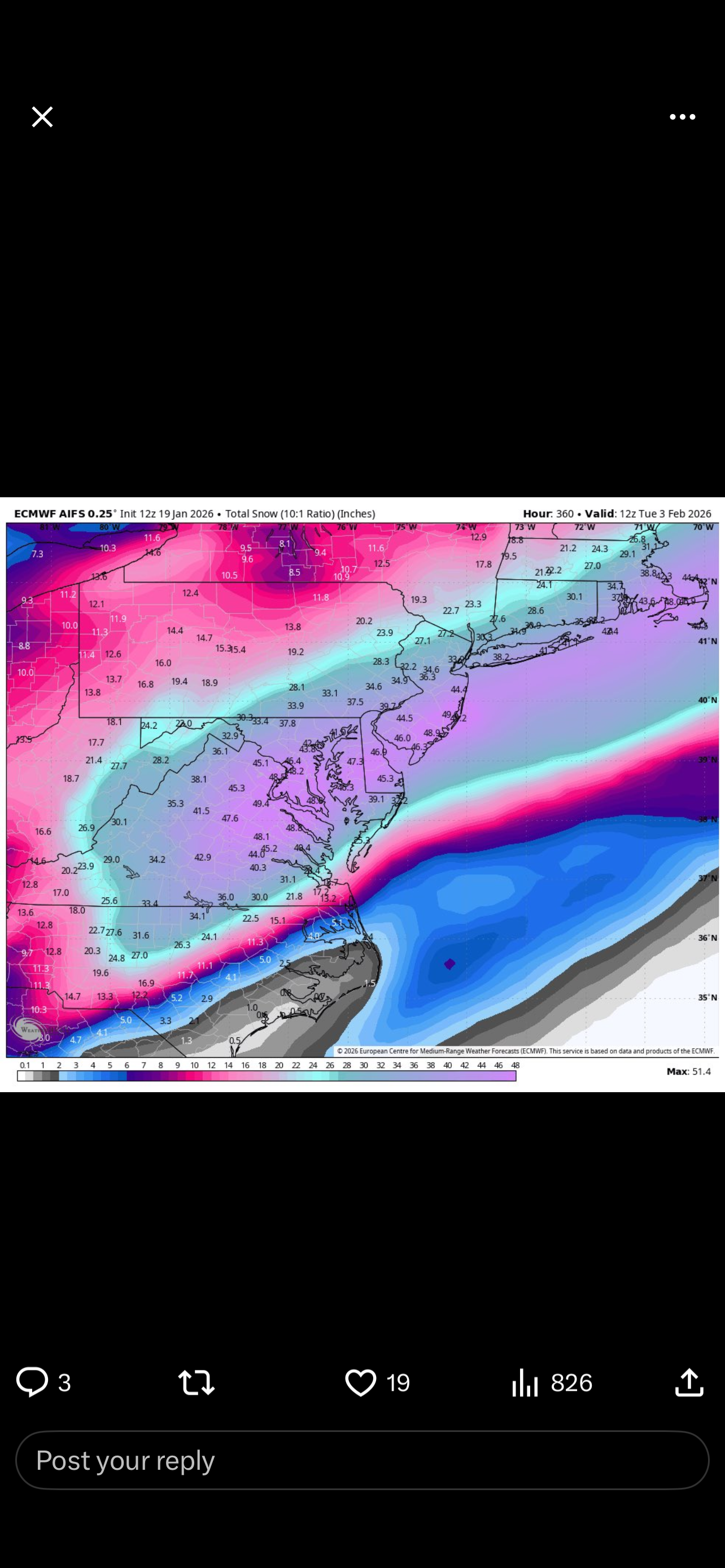
12z EPS is a Dream Run for NC/VA.
-

January 2026 regional war/obs/disco thread
brooklynwx99 replied to Baroclinic Zone's topic in New England
AIFS-EPS likes that idea
-
anyone have the kuchera euro ai clown map for the whole run?
-
They both sit on these things until it's obvious. I kind of get NashSevereWX's hesitancy as they are entirely social media based and crowd-funded, and when stuff doesn't go to forecast, they get absolutely hammered.
-
Pete's the best. I went to school with him and he was one of my heroes of forecasting. Always was able to spot things others would miss.
-
Rise of the Machines: January 18-19 Winter Storm Obs Thread
vortex95 replied to WxWatcher007's topic in New England
So the rear squalls verified well. HRRR did a great job. Was it bursty like snow squalls? -
Climo is climo. I can't buy the 12z euro for 1 simple reason. It would be one of the top 5 biggest storms in history down this way. Idk if this is the kind of setup for something that historic. Blizzard of 96 was 24" in Roanoke. Feb 2014 was close to 20". A 15-20" storm is quite rare. Imo, the DC area is more likely to get 15-20" than central and swva. That said, my yard is in a pretty good spot and I'm pretty fired up over the potential.
-
I love Ruth Chris (hint hint). Oh i’ll pick up the check too. Hope the snow will have have melted by March.
-
EPS trend gif would help visuals
-
Threads created for this weekends storm. .
-
2025-2026 Fall/Winter Mountain Thread
CheoahBald1 replied to Buckethead's topic in Southeastern States
BAM weather is dying for a NW trend , you can tell he is bias for the north lol . -
https://x.com/burgwx/status/2013321433670144421?ct=rw-null .
-
Rise of the Machines: January 18-19 Winter Storm Obs Thread
vortex95 replied to WxWatcher007's topic in New England
So you got your 6" and that breaks the 6" drought for Weymouth. Happy dayZZZZZZZZ are here again!? LOL. I don't want to hear it from you anymore. This winter is turning out pretty good now, esp, since we just filled the "snow hole" area in parts of RI and ern MA and given recent winters. And it will be *preserved* well for the next week being so cold except Thu, but some melting will actually be good b/c it will refreeze *hard* into a glacier block. Have lemons, make lemonade! But wishful thinking? CoastalWx already I bet: "The pseudo-Miller A this weekend will miss SNE and may give Norfolk VA its all-time record snowstorm. Why can we get that here???!!!" -
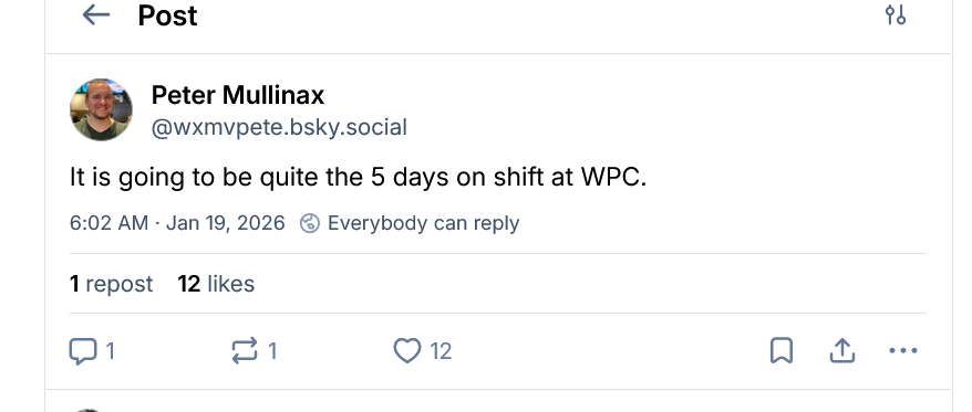
good sign: https://bsky.app/profile/wxmvpete.bsky.social/post/3mcril3p4522p
-
The hesitancy of NWS-Nashville and NashSevereWx...I don't get it. Their downplaying of the weekend event is irking me.