All Activity
- Past hour
-
78 / 66 day 2 for a few and for many others day 1 of a 5-6 or 7 day heatwave peaking Wed - Sat. Isolated / scattered storms Fri - Sat and look for MCS which looks north into New England if develops. Sunday looks a bit unsettled but enough sun extends the heatwave for the areas. Ridge > 594 DM and 850s peaking >22c Thu-Sat argues upper 90s / low 100s, maybe mid low - mid 90s in central park. Next week near to slightly above normal between 7/7 - 7/14 with ridge pulling back west and weak trough into the northeast. WC / Rockies ridge pumps up and pushes pieces of heat east towards mid month. The usual transition from these strong ridge / heat spikes is followed by near / below normal for 3 - 7 days before next push of heat.
-

Central PA Summer 2026 Discussion/Obs Thread
PaWeatherNut replied to Voyager's topic in Upstate New York/Pennsylvania
Hey all. First time poster, long time reader. I was up in Slate Run on Pine Creek during the worst of the July 2011 heatwave. All the trout were huddled where the tiny seeps and feeders trickled into the main stem of Pine creek. They were so distressed you could pick them up with your hands. Walleye just floated up to the surface and you could grab them by hand as well. I don't know what the water temperature was, but there was no relief from being in the water. -
 sfed11 joined the community
 -
Looks like we are going to finish June with a negative temperature departure for the month. A warm period at the beginning and end of the month couldn't overcome an incredibly pleasant middle part. It would take something like +42 departure today to bring us back to normal. It might feel like it with the humidity today, but that is a different story.
-
all kidding aside July 4th PM has some potential for the atmosphere to put on its own show in the region
-
81/78/89 at 8:30am... No thanks
-

Central PA Summer 2026 Discussion/Obs Thread
Dillsburg Keith replied to Voyager's topic in Upstate New York/Pennsylvania
Early July 1966-104,107,104 followed by a 100 on July 10th,and 100 on July 26th. and most other days that Summer were in the 90's -
Even the GFS has a quite a bit of elevated CAPE with at least western sections on the instability gradient. It will be an interesting evening/overnight, especially if the NAM sort of verifies with the advection of rather impressive MUCAPE. The HRRR I think has been solid with the idea of convection moving into the region this evening but I think this may end up being a bit more impressive than modeled. These are tough environments, even more mesos to handle
-

Central PA Summer 2026 Discussion/Obs Thread
mahantango#1 replied to Voyager's topic in Upstate New York/Pennsylvania
I can remember back in 1988 summer when it was hot. I took a thermometer in the creek at my place where we have a swimming hole in the middle of the creek. The hole is about 5 foot deep in between 2 big rocks. In between the rocks the current flows, thats where I held a wire that was attached to My thermometer about half a foot under the water. The temperature was 88. The water felt like bath water. You cooled off but it wasn't exactly what I call refreshing. If we get several days of hot temperatures this week I'll have to see what the temperature of the creek is this time. -

Fireworks Heat Contest W 7/1 - S 7/4 for Five MA Airports
GramaxRefugee replied to nw baltimore wx's topic in Mid Atlantic
DCA: 98, 102, 103, 101 BWI: 97, 102, 103, 100 IAD: 96, 99, 101, 98 SBY: 96, 99, 101, 98 RIC: 97, 100, 102, 99 Total Rain: 0.05 -
I planted Texas grass seed in my full sun spots for a reason…
-
Also where there’s any compressional heating zone. That area just ahead of the seabreeze can really roast. Sometimes that’s around the Southern State Parkway/Five Towns to Roosevelt Field.
-
86 yesterday on the south shore For Long Island, the Euro has a prominent sea breeze on Thursday so Euro only has 90s for the island that day. West wind comes back on Friday (Euro) so that would be our best chance at 100+. GFS has more of a westerly wind both days but there will probably be a sea breeze both days. Where it sets up during the day will dictate the max temps. Longer it holds off, the hotter it'll get
-
Woke up to 24C/77F maybe locally more like 25C as of 7:30, I see CU in the distance with minor haze - that's my kind of morning! Low of 21C only. They adjusted for 44 humidex.
-
Not exactly— there’s definitely indication that the line bends southeast. Down to Boston in the mix for severe along the coast.
-
Still stuck in the clouds and fog, although point has 94 for the high today. It's the only 90+ temp in the forecast this week after yesterday's high temp busted by 22 degrees... .75" of rain the past 24 hours from a couple rounds.
-

Junorch obs and discussion 2026
Damage In Tolland replied to Damage In Tolland's topic in New England
Wildfire smoke is back. Noticed some yesterday and today it’s very noticeable -

Pittsburgh PA Summer 2026 Thread
ChalkHillSnowNut replied to TheClimateChanger's topic in Upstate New York/Pennsylvania
NOT looking forward to the next several days - Today
-
(002).thumb.png.6e3d9d46bca5fe41aab7a74871dd8af8.png)
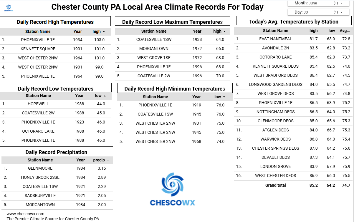
E PA/NJ/DE Summer 2026 Obs/Discussion
ChescoWx replied to PhiEaglesfan712's topic in Philadelphia Region
Today should be our last sub 90 degree high until Monday. Mid to upper 80's today rising into the low to mid 90's tomorrow and then upper 90's in higher spots to near 100 in our valley locations both Thursday and Friday. Shower chances increase later July 4th with the days trending slightly cooler with highs by Monday in the upper 80's.
-
Central PA Summer 2026 Discussion/Obs Thread
ChescoWx replied to Voyager's topic in Upstate New York/Pennsylvania
Today should be our last sub 90 degree high until Monday. Mid to upper 80's today rising into the low to mid 90's tomorrow and then upper 90's in higher spots to near 100 in our valley locations both Thursday and Friday. Shower chances increase later July 4th with the days trending slightly cooler with highs by Monday in the upper 80's.
-
Glad the temps haven’t reached 100 yet, highs around 95 and only a couple heat advisories this summer which is pretty surprising.
-

Central PA Summer 2026 Discussion/Obs Thread
Mount Joy Snowman replied to Voyager's topic in Upstate New York/Pennsylvania
MDT daily record highs for July 1 thru July 4 -- 100, 104, 107, and 104. That is one tough set of records to breach. Tomorrow is obviously the most gettable but that's also the one day where my current forecast is under 100. We shall see but quite the historic heat wave on tap regardless. -
woke up to 80, lol
-
Historically will this 3-4 day stretch sit near the top? I think last time 3 days of 100 or greater was July 93?
-

Fireworks Heat Contest W 7/1 - S 7/4 for Five MA Airports
nw baltimore wx replied to nw baltimore wx's topic in Mid Atlantic
Just a reminder that this will stay open for entries and edits until about 11PM tonight. In the spirit of transparency, my entries above are final. -
Central PA Summer 2026 Discussion/Obs Thread
ChescoWx replied to Voyager's topic in Upstate New York/Pennsylvania
Of course station location placement and relative elevation


.thumb.jpg.ad3a2e31d30aff035044689b311a0540.jpg)