All Activity
- Past hour
-

December 2025 regional war/obs/disco thread
Sey-Mour Snow replied to Torch Tiger's topic in New England
Talk to us when it shows it at 12z -

Central PA Winter 25/26 Discussion and Obs
Mount Joy Snowman replied to MAG5035's topic in Upstate New York/Pennsylvania
Low of 26 and nothing reaching the ground, despite some light snowfall returns and a nearly saturated atmosphere. Also, yesterday morning my low actually dropped to 10. Have a good one, everyone. -

E PA/NJ/DE Winter 2025-26 Obs/Discussion
Birds~69 replied to LVblizzard's topic in Philadelphia Region
29F, some stuff on radar...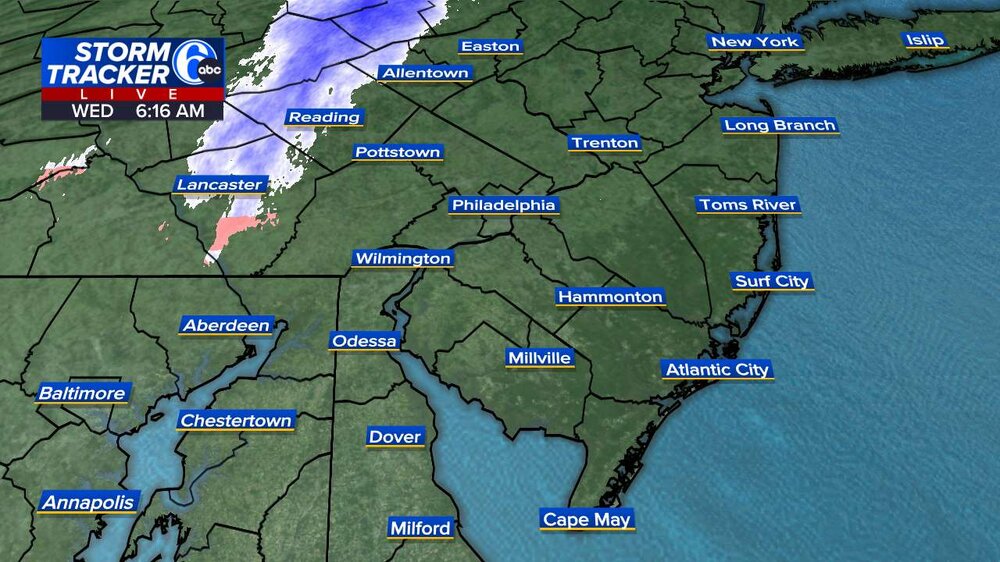
-

Pittsburgh/Western PA WINTER ‘25/‘26
TimB replied to Burghblizz's topic in Upstate New York/Pennsylvania
Yep this thing never had a chance. Hope we cash in with a nice little event this weekend because after that, oof. -

-
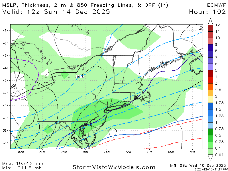
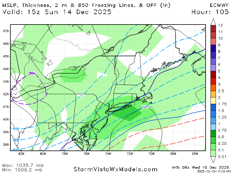
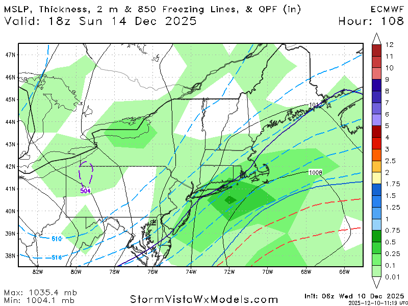
And now the Euro is slightly more amplified at 6z like the Aifs.
-
December 2025 regional war/obs/disco thread
Sey-Mour Snow replied to Torch Tiger's topic in New England
GFS is the steadiest with this one. Can’t trust those damn off hour runs especially Euro it’s done this way too many times. My rule of thumb is unless we get two complete model 00z/12z suites by gfs and euro in a row showing a storm I’m not buying it. -
Euro is back to a little snow event
-

2025-2026 ENSO
PhiEaglesfan712 replied to 40/70 Benchmark's topic in Weather Forecasting and Discussion
88-89 was the strong la nina. 89-90 was a dissipating weaker la nina/cold neutral, and was firmly ENSO neutral by the time the winter was over. The IOD was still at -1.4 on November 24, pretty much comparable to 2016 and 2022, both of which were low snow winters at PHL, and torched in January and February. The mid-March snowstorm in 2017 kept that year from being another below 10 inch snowfall season at PHL, and we all know the disaster that 2022-23 was. Cold and low snow Decembers are the worst combination. They almost always produce torch Januarys and Februarys. Come to think of it, I can't remember a time when a cold and low snow December produced a great rest of the winter. -

Winter 2025-26 Short Range Discussion
Baum replied to SchaumburgStormer's topic in Lakes/Ohio Valley
Not necessarily -
Quiet possible it misses but not sure AI models still show a nice hit
-
Yep every model. These models ar horrendous. Cant look at them past 5 days.
-

Central PA Winter 25/26 Discussion and Obs
Voyager replied to MAG5035's topic in Upstate New York/Pennsylvania
I like the last part that says warming trend. Just wish there weren't question marks after it. -

December 2025 regional war/obs/disco thread
HoarfrostHubb replied to Torch Tiger's topic in New England
A dusting here. -

2025-2026 Fall/Winter Mountain Thread
Buckethead replied to Buckethead's topic in Southeastern States
URGENT - WINTER WEATHER MESSAGE National Weather Service Greenville-Spartanburg SC 227 AM EST Wed Dec 10 2025 NCZ048>050-102000- /O.NEW.KGSP.WW.Y.0014.251210T1800Z-251211T1500Z/ Madison-Yancey-Mitchell- Including the cities of Faust 227 AM EST Wed Dec 10 2025 ...WINTER WEATHER ADVISORY IN EFFECT FROM 1 PM THIS AFTERNOON TO 10 AM EST THURSDAY ABOVE 3500 FEET... * WHAT...Snow expected above 3500 feet. Total snow accumulations up to 4 inches. Winds gusting as high as 55 mph. * WHERE...Madison, Mitchell, and Yancey Counties. * WHEN...From 1 PM this afternoon to 10 AM EST Thursday. * IMPACTS...The heavy snow will create snow covered roads and produce scattered power outages. The hazardous conditions could impact the Wednesday evening and Thursday morning commutes. Strong winds will likely cause damage to trees and power lines. Sent from my SM-S908U using Tapatalk -
Good if it isn’t going to snow bring on the warmth, we take
-
Columbia: Temps on the rise. Down to 27 at 5am, but 28 at 6am.
-
The yards being muddy is a good sign. That usually means the drought is coming to an end soon.
-

December 2025 regional war/obs/disco thread
Kitz Craver replied to Torch Tiger's topic in New England
Close the shades. -

Central PA Winter 25/26 Discussion and Obs
mahantango#1 replied to MAG5035's topic in Upstate New York/Pennsylvania
-
Weeeeeee.
-
December 2025 regional war/obs/disco thread
Sey-Mour Snow replied to Torch Tiger's topic in New England
And the torch won’t make the snow go poof, bc there won’t be any on the ground. -
Sunday is quickly trending to a disjointed, sheared mess on the operationals and the ensembles. Raging fast flow, the +PNA is very progressive (as usual) and there is no traffic/blocking in the Atlantic to slow the flow down, it just races right off the coast as FROPA
-

E PA/NJ/DE Winter 2025-26 Obs/Discussion
penndotguy replied to LVblizzard's topic in Philadelphia Region
27F Dp22 with cloudy skies, few scattered flakes here and there. -
Starting to get that bad vibe that we’re going snowless for December. What a waste of cold.