All Activity
- Past hour
-

Occasional Thoughts on Climate Change
WolfStock1 replied to donsutherland1's topic in Climate Change
Thought this bit was kind of odd: "The revised analysis shows economic damages from climate change till mid-century are substantial and outweigh the costs of mitigation" It seems the relationship of the costs shouldn't necessarily be 1:1 or anything like that. Every dollar spent on mitigation doesn't lessen the costs of CC by a dollar - it may be much less or it may be much more; and you may actually want one or the other. E.g. say the costs due to CC (generally storms - wind and flooding) end up being $500 billion in a given area over the next 25 years, if no mitigation was done. You could spend say twice that - say $1 trillion - on sea walls, stricter building codes, river flood mitigation (drainage and walls), and lessen the resulting damage costs from $500B to say $300B. Was it bad to spend the $1 trillion, since the net loss is $700B? Maybe, but maybe not if you consider that there are also lives involved; presumably less lives lost in the do-mitigate case. Looking from a strictly financial standpoint - it seems like you generally would *want* your mitigation costs to be less than the damage costs, right? This is due to the unpredictable nature of storms. If you spend more money to mitigate then the delta between the two is by definition wasted money - generally. That said - there's probably some low-hanging fruit that is worthwhile. E.g. the US built a series of flood-control dams after the big Ohio river flood in 1937; this likely ended up saving money in the long run, so that might be a case where the cost of mitigation reduced the likely cost of non-mitigation damages. Same is true for flood walls in various places - usually it's money well spent. But it's rarely a 1:1 tradeoff though; so comparing the two sets of figures seems odd. -
Actually, 6z euro looks better.
-
Trending down, yes, but the thing is AAM forecasts have been biased too negative over the past 30 days. When correcting for that, AAM may be closer to neutral.
-

December 2025 Short/Medium Range Forecast Thread
jaxjagman replied to John1122's topic in Tennessee Valley
Look at the SOI around the 23 of Nov then next week,this is when the models get chaotic with the MJO,but even that today, look how negative the SOI is today,the LaNina base state has been taking out and it is acting more Nino now,seems like the JMA and Euro are going into the COD,then back into the WH afterwards possibly and should probably climb back out the COD,actually the GEFS isnt far behind.png.7ad43df83999243f6419d681cee62440.png)
-
-
So much for the snow melting.
-

December 2025 regional war/obs/disco thread
WinterWolf replied to Torch Tiger's topic in New England
Wow..ok. Thanks for the info Paul. -
Low of 30.0 on the dot. Once again, heavy frost
-
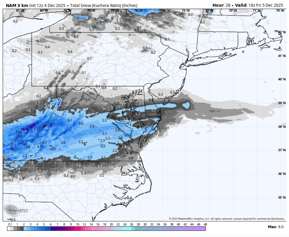
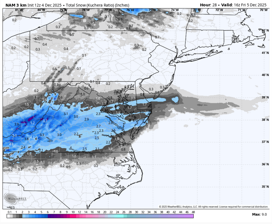
Probably the best run of the 3k (not saying much). Gets the 2" line to EZF, about 1 to DC.
-

December 2025 regional war/obs/disco thread
weatherwiz replied to Torch Tiger's topic in New England
I'll have to go look at the latest SOI now but something about what he posted doesn't make sense. A prolonged period of negative SOI would typically coincide with EL Nino conditions while a prolonged period of positive SOI coincides with La Nina. A tanking SOI would imply either going towards EL Nino or an ongoing EL Nino event would be strengthening. -

Pittsburgh/Western PA WINTER ‘25/‘26
TimB replied to Burghblizz's topic in Upstate New York/Pennsylvania
Heard on the radio that we could set a daily record low tonight. Granted the record (12) is easily the softest December record on the books, as the 5th is the only day that has never reached single digits. -
I want to send SEAL team 6 after this guy .
-
December 2025 regional war/obs/disco thread
WinterWolf replied to Torch Tiger's topic in New England
Maybe the date can bring about a “changeable event” -

December 2025 regional war/obs/disco thread
Damage In Tolland replied to Torch Tiger's topic in New England
Boobs 4 days? -
December 2025 regional war/obs/disco thread
WinterWolf replied to Torch Tiger's topic in New England
So in layman’s terms, it’s really no big deal, right? We are in a Niña…does the SOI tanking mean the Nina is getting stronger, or again you have to measure it along with the other indexes you mentioned, to actually know anything. Sounds like a lot of mumbo jumbo that tells us very little in the end. -
I'm not a met, but your expectations seem to be in line with the latest guidance. I graduated from UVa twice, so I am familiar with how beautiful the grounds get with a nice coat of white powder. Enjoy!
-
Gets kind of stretched out as it reaches us and loses a little bit of its punch. Meh.
-
Records: Highs: EWR: 75 (1998) NYC: 74 (1998) LGA: 74 (1998) JFK: 70 (1998) Lows: EWR: 9 (1940) NYC: 10 (1882) LGA: 12 (1940) JFK: 15 (1966) Historical: 1786 - The first of two great early December storms began. The storm produced 18 inches of snow at Morristown NJ, and twenty inches of snow at New Haven CT. It also resulted in high tides at Nantucket which did great damage. (David Ludlum) 1886: Heavy snow fell on parts of the South and southern Appalachians through the 6th. Montgomery, AL recorded their greatest snow on record as 11 inches fell. An amazing 33 inches fell at Asheville, NC and 25 inches fell at Rome, GA. (Ref. AccWeather Weather History) 1952: The month of December started off with chilly temperatures in London. This cold resulted in Londoners to burn more coal to heat up their homes. Then on December 5, a high pressure settled over the Thames River causing a dense layer of smog to develop. The smog became so thick and dense by December 7 that virtually no sunlight was seen in London. Most conservative estimates place the death toll at 4,000, with some estimating the smog killed as many as 8,000 individuals. 1953: An ice storm occurred in the Southeast, MN. 2 inches of ice formed on telephone wires. (Ref. AccWeather Weather History) 1957: Early season snow; 11 inches DC, 8 inches Baltimore, 14 inches Loudoun Co. A weak wave of low pressure moves east from Kentucky to the Atlantic Ocean where warm Gulf Stream waters caused very rapid development. Snow rapidly spread throughout the metropolitan area during the morning of the 4th and some became heavy. The blinding snow continued into the afternoon and finally ended during the evening, with 11.4 inches of snow measured at National Airport. That was the heaviest snowfall at National Airport since the spring snowstorm of March 1942. Up to 14 inches was reported in the suburbs. Most of the snowfall took place with temperatures hovering at or near 32 degrees Fahrenheit. (p. 66 Washington Weather Book 2002 by Ambrose, Henry, Weiss) 1964: A big ice storm was in progress across the Northeast. Ice accumulated as much as an inch and a half thick in some places in Massachusetts and eastern New York. Over 80,000 homes were without power after the storm. Some customers did not get their power back for five days. (Ref. AccWeather Weather History) 1972 - Winds gusting to 70 mph sent the temperature at Livingston, MT, plunging from 52 degrees to 18 degrees in just twenty minutes. (The Weather Channel) 1973: Southwest Iowa was in the midst of experiencing one of their worst winter storms in history. A large number of power lines and trees were downed due to ice and snow causing power outages lasting several days. Travel was nearly impossible and most schools closed for two days. Several towers were also toppled in Hamilton and Hardin Counties. (Ref. Wilson Wx. History) 1982 - The temperature in New York City's Central Park reached 72 degrees to establish a then record high for December. The month as a whole was also the warmest of record. (The Weather Channel) 1982: A ridge of upper level high pressure off the southeast coast pumped warm south to southwesterly winds from the Tennessee Valley to New England bringing record high temperatures. Other daily record highs included: Richmond, VA: 77 °F, Cape Hatteras, NC: 76 °F, Roanoke, VA: 76 °F, Charleston, WV: 76 °F, Washington, DC: 75 °F, Lynchburg, VA: 75 °F, Baltimore, MD: 74 °F, Sterling (Dulles Airport), VA: 74 °F, Hartford, CT: 71 °F, Wallops Island, VA: 71 °F, Elkins, WV: 70 °F, Portland, ME: 69 °F (broke previous record by 12 degrees), and Bridgeport, CT: 61 °F.(Ref. The Weather Channel) Boston, Massachusetts had a 57 °F the warmest low temperature for the month of December. (Ref. NOAA Boston Weather Events) 1987 - A cold front crossing the Pacific Coast Region brought high winds and heavy rain to California. Thunderstorm winds gusted to 55 mph at Newport Beach CA, and Mount Wilson CA was drenched with 2.17 inches of rain in six hours. Gale force winds prevailed along the Northern Pacific Coast, and winds in the Tehachapis Mountains of southern California gusted to 60 mph. (Storm Data) (The National Weather Summary) 1988 - Gale force winds continued to usher cold arctic air into the northeastern U.S. Winds gusted to 65 mph at Windsor Locks CT. Up to a foot of snow blanketed the higher elevations of Vermont. (The National Weather Summary) (Storm Data) 1989 - Seventeen cities in the eastern U.S., including nine in Florida, reported record low temperatures for the date. Lakeland FL reported a record low of 31 degrees, and Watertown NY was the cold spot in the nation with a low of 20 degrees below zero. (The National Weather Summary) (Storm Data) 1992: The western and southwestern U.S. was in the middle of a major four day winter storm. Flagstaff, AZ was buried under 23 inches of snow and 22 inches piled up at Sandia Peak, NM.(Ref. AccWeather Weather History) Up to six inches of rain was reported in some mountain locations of southern California with a half to two inches in the valleys. Local flooding, mud slides, standing water, and road closures resulted. Six inches to two feet of snow fell in the higher elevations in the mountains. Flooding in Tijuana, Mexico killed four and left hundreds homeless. Two days earlier, the same storm produced two F1 tornadoes near Santa Rosa, CA. The storm moved out in to the southern Plains during the late afternoon/early evening hours lingering through the 5th killing at least four people. The storm brought 4 to 9 inches of snow to northwest and north-central Oklahoma, and 1 to 4 inches of snow and sleet to much of central Oklahoma. Snow, sleet, and freezing rain fell over a large part of northeast Oklahoma. Behind the cold front and storm, bitterly cold temperatures were felt from the northern Rockies to the Pacific Northwest. Record low temperatures for the date included: West Yellowstone, MT: -36 °F, Rawlins, WY: -26 °F, Pocatello, ID: -22 °F, Laramie, WY: -20 °F, Ennis, MT: -17 °F, Elk Mountain, MT: -12 °F, Scottsbluff, NE: -10 °F, Centennial, MT: -10 °F, Burns, OR: -7 °F, Salt Lake City, UT: 3 °F and Olympia, WA: 19 °F. (Ref. Wilson Wx. History) 1994: Widespread rainfall of 3 to 7 inches, with a maximum of 14.33 inches was measured across east Palm Beach County, Florida during a 24-hour period. Roadways were flooded and minor water damage was reported to some businesses in Delray Beach and Boca Raton. The combination of heavy rains and low astronomical tides caused many sea walls along canals to collapse. Sugar cane harvesting was halted due to the flooding of fields. A few record highs were set in Florida including: Fort Myers, FL: 87 °F, Tampa, FL: 86 °F and Vero Beach, FL: 84 °F. (Ref. Wilson Wx. History) 1996: A persistent westerly flow aloft produced high winds across and near the Front Range Foothills in Colorado. Several locations reported hurricane force wind gusts of 100 to 120 mph. The high winds downed trees and power lines, blew a semi truck over and caused structural damage. Some of the highest winds gusts included: Blackhawk: estimated at 120 mph, Aspen Springs: 115 mph, Eldora Ski Resort: 100 mph, Atop Shanahan Ridge near Boulder: 75 mph, Conifer: 74 mph and 71 mph at the Rocky Flats Environmental Test Facility. (Ref. Wilson Wx. History) 1998: An unseasonable upper level ridge extended from off the southeast coast across Florida into the Gulf of Mexico bringing record high temperatures from the Plains to the East Coast. The temperature soared to 76 °F at Washington, DC to establish a new all-time December high temperature record. The record was to be short-lived, however, as the temperature would top out at 78 °F on the 6th and 79 °F on the 7th. Other daily record highs for the date included: Richmond, VA: 77 °F-Tied, Atlanta, GA: 76 °F, Sterling (Dulles Airport), VA: 75 °F, Athens, GA: 75 °F-Tied, Lynchburg, VA: 75 °F-Tied, New York (Central Park), NY: 74 °F, Atlantic City, NJ: 73 °F, Bridgeport, CT: 72 °F (broke previous record by 11 degrees), Hartford, CT: 71 °F, Boston, MA: 70 °F, Chicago, IL: 66 °F. (Ref. Wilson Wx.- Many additional temperatures given at this link) 2002 - An early season winter storm brought an expansive shield of snow and ice through much of the eastern U.S., from the lower Ohio Valley, southern Appalachians and into the Northeast. Snow accumulations of 4-8 inches were common along the northern edge of the precipitation shield, while a significant accrual of glaze occurred in the Carolinas. The storm caused at least 17 fatalities, mostly from traffic accidents (CNN). In the Carolinas, electric utilities provider Duke Power characterized the ice storm as the worst in the company's history, with 1.2 million customers or nearly half its entire customer base without power on the morning of the 5th. This surpassed electrical outages inflicted by Hurricane Hugo as it swept through the central Carolinas in September 1989. The Baltimore-Washington area was under Winter Storm Watches as low pressure developed along a stalled front across the Gulf Coast that moved through two days before. Low pressure moved from the Louisiana coast on the 4th to off the Carolina coast on the 5th. When it was over BWI/Marshall had picked up 7.4 inches, 6.2 inches at Dulles Airport in Sterling, VA and 6.1 inches at National airport in Washington, DC. An early season winter storm brought an expansive shield of snow and ice through much of the eastern U.S., from the lower Ohio Valley, southern Appalachians and into the Northeast. Snow accumulations of 4-8 inches were common along the northern edge of the precipitation shield, while a significant accrual of glaze occurred in the Carolinas. The storm caused at least 17 fatalities, mostly from traffic accidents (CNN). In the Carolinas, electric utilities provider Duke Power characterized the ice storm as the worst in the company's history, with 1.2 million customers or nearly half its entire customer base without power on the morning of the 5th. This surpassed electrical outages inflicted by Hurricane Hugo as it swept through the central Carolinas in September 1989. (Ref. AccWeather Weather History) 2009: SE TX received its earliest snow of record. Houston officially reported 1.0 inch (old record: 1.4 inches on 12/10/2008 and a trace on 12/10/1944). 4 inches in Lake City and Boling were the greatest amounts reported; Bay City reported 2.0 inches while 0.2 inches was reported in Victoria. (Ref. Weather Guide Calendar with Phenomenal Weather Events 2011 Accord Pub. 2010, USA)
-

December 2025 regional war/obs/disco thread
40/70 Benchmark replied to Torch Tiger's topic in New England
Hopefully a hot date with Heather Archambault! -

December 2025 regional war/obs/disco thread
Typhoon Tip replied to Torch Tiger's topic in New England
I can't make this one, Ray - previous plans -
Yea, probably not moving it this late in the game, anyway, unless there was a real concerted push.
-
Nice pre-empt for melts just in time for the upcoming pattern to fail. Well done.
-
3k looks better as well.
-
13th I have something in Stamford, CT at 6:00 PM so wouldn't be able to make it
-
I’m guilty as charged. I mean I do think that matters but back to my point on CAD. It only matters if you have an anchored high that can take full advantage of it. This transient mess doesn’t help.