All Activity
- Past hour
-
(002).thumb.png.6e3d9d46bca5fe41aab7a74871dd8af8.png)
E PA/NJ/DE Winter 2025-26 Obs/Discussion
ChescoWx replied to LVblizzard's topic in Philadelphia Region
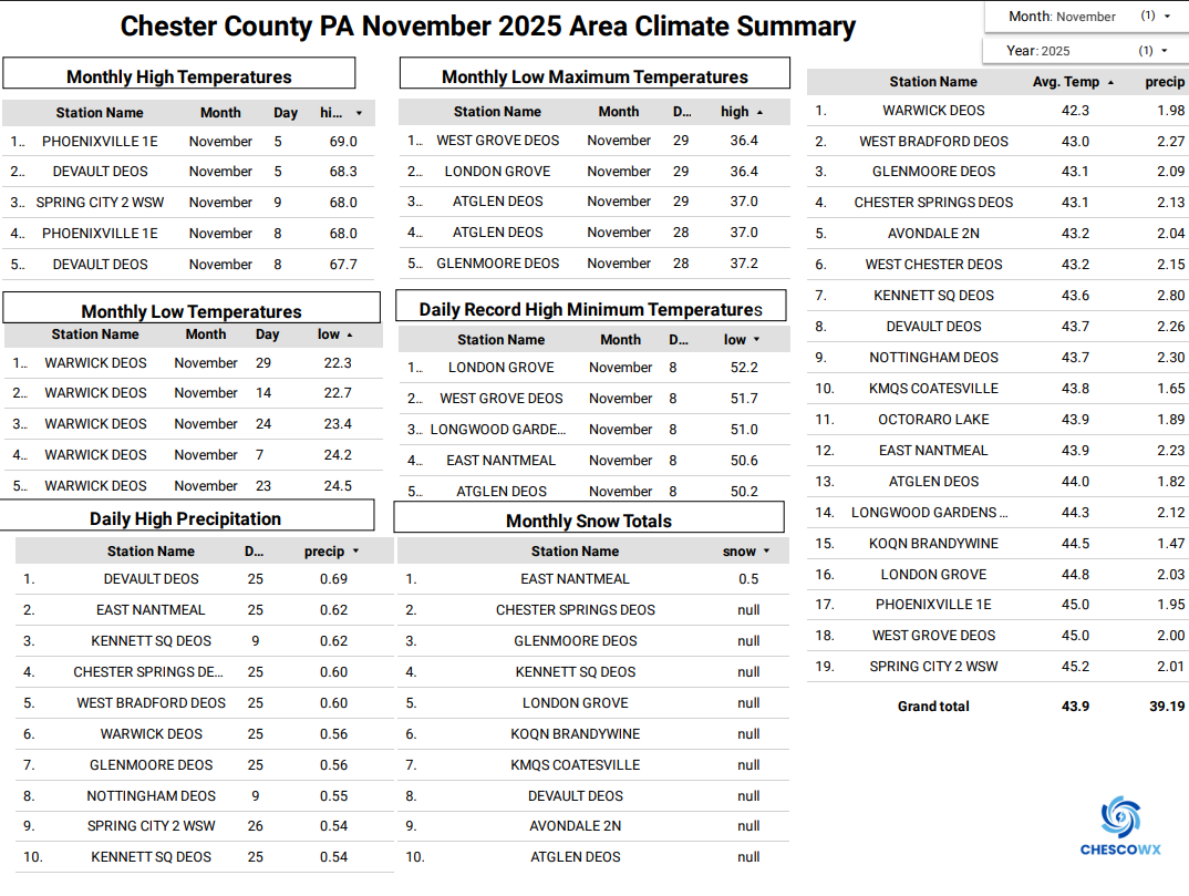
Below is the November Climate Summary for Chester County PA. With our average temperature of 43.8 degrees, we were just a little below Average 44.0. As you would suspect this was the 67th chilliest November out of 133 years. Our coldest November on record was the 37.5-degree average back in 1977. The warmest November on record was way back in 1931 at 50.8 degrees. We averaged across the area 2.06" of rain which is about 1.30" below normal. Our wettest November was in 2018 when we averaged 8.22" of rain. Snowfall was 0.5" with is 0.5" below normal for the month. Our snowiest on average November was back in 1938 when we averaged 10" of snow.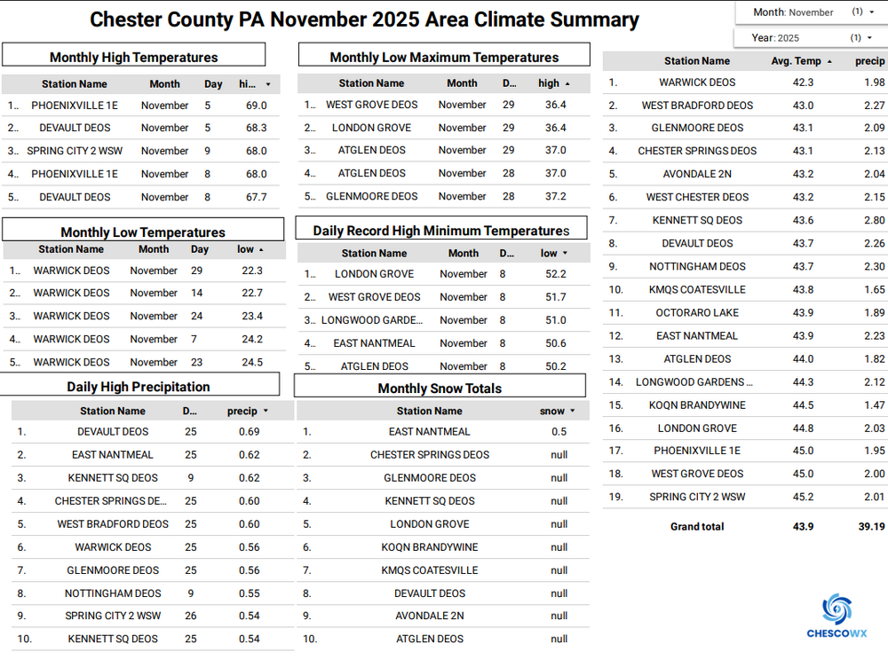
-

Winter 2025-26 Medium/Long Range Discussion
hlcater replied to michsnowfreak's topic in Lakes/Ohio Valley
Some reason to believe week 3 might be a return to a cooler pattern which is why I posted in the other thread that the lead system this weekend matters so much as it would help mitigate warming in week 2 in the northern half of the sub. -

E PA/NJ/DE Winter 2025-26 Obs/Discussion
Mikeymac5306 replied to LVblizzard's topic in Philadelphia Region
Ji needs to talk to someone. -

E PA/NJ/DE Winter 2025-26 Obs/Discussion
Birds~69 replied to LVblizzard's topic in Philadelphia Region
I wouldn't mind a parade of clippers which we haven't seen in years it seems. They tend to overperform or at least give you a solid inch or two.....nickel and dime ourselves to death. 38F -
My wife's grandfather used to talk about the March 6, 1962 storm. The forecasters the night before were calling for a few inches, and they woke up to a blizzard that ended up dropping 30.5" in Staunton.
-

December 2025 Short/Medium Range Forecast Thread
Carvers Gap replied to John1122's topic in Tennessee Valley
The 18z HRRR has decent returns over @John1122's and @Shocker0's places. Mix ove TRI. Snow over SW VA and SE KY. If that stays the same, I would expect MRX and JKL hoist winter wx products tomorrow evening at the very lates...maybe tomorrow morning once the actual axis of precip is determined. -
The days when models underestimated how often the mountains eat up our snow. Clippers were the source of many busts.
-
this is starting to become a December to forget. Shocking right?
-

Mid to long range discussion- 2025
WinstonSalemArlington replied to wncsnow's topic in Southeastern States
-
we should stop using models and go back to pencil and paper like in the 936-1212 days
-
E PA/NJ/DE Winter 2025-26 Obs/Discussion
Birds~69 replied to LVblizzard's topic in Philadelphia Region
We play this damn game every year. At least the liquor store entrances/exits are well salted... Ji "Worst hobby ever" 38F -
The fast Pacific flow and lack of blocking didn’t allow the cold high to stay anchored over New England. The WAR flexed just enough so the thermal gradient got pushed north of NYC. So these features negated the usual colder influence we see with lows tracking south of Long Island. Plus the low was strung out on a N-S axis without enough deepening near the benchmark to allow the cold air to wrap in behind the storm.
-
December 2025 Short/Medium Range Forecast Thread
Carvers Gap replied to John1122's topic in Tennessee Valley
National Weather Service Morristown TN 117 PM EST Wed Dec 3 2025 ...New DISCUSSION... .KEY MESSAGES... Updated at 115 PM EST Wed Dec 3 2025 - Dry weather today and Thursday before increasing precipitation chances Thursday evening into Friday. - Moderate chances for light snowfall across extreme northeast TN and southwest Virginia early Friday morning. Minor impacts are possible. Elsewhere, will get rain Thursday night into Friday. - Very low probability of rainfall this weekend. && .DISCUSSION... Issued at 115 PM EST Wed Dec 3 2025 In the upper levels, nearly zonal flow or slight troughing will be over the region through the weekend as a big, broad trough dominates the Central and Eastern U.S. At the surface, high pressure will be over the region through Thursday. Thursday night into Friday, a Gulf Low moving eastward along the Gulf Coast will bring overrunning moisture into the region. Rain is expected for most of the region Thursday night into Friday. Temperature profiles support light snow Thursday night into Friday morning for Southwest Virginia and extreme Northeast Tennessee. Freezing rain probabilities are low in SW Virginia and extreme NE Tennessee and model soundings show a deep enough cold layer to support snow. By mid Friday morning temps will warm enough for a changeover back to rain. The lower elevations may get up to half an inch accumulation and the higher elevations may get up to an inch of accumulation. Minor travel impacts will be possible during the morning commute Friday but will be confined to SW Virginia and extreme NE Tennessee. The Tri-Cities area may see a few flakes but little to no accumulation is expected there. HREF guidance through 12Z Friday have snow totals below one inch. The Tennessee Valley won`t see any frozen precip with this system. HREF guidance doesn`t cover this whole event yet so hopefully the next forecast cycle will bring more confidence. Rain chances will be very low for the weekend and into early next week. One or more shortwaves may move through the pattern but moisture will be limited. Rain or possibly even a brief snow will be possible at some point but there is too much uncertainty to nail down specifics at this time. Widespread travel impacts are unlikely this weekend. -
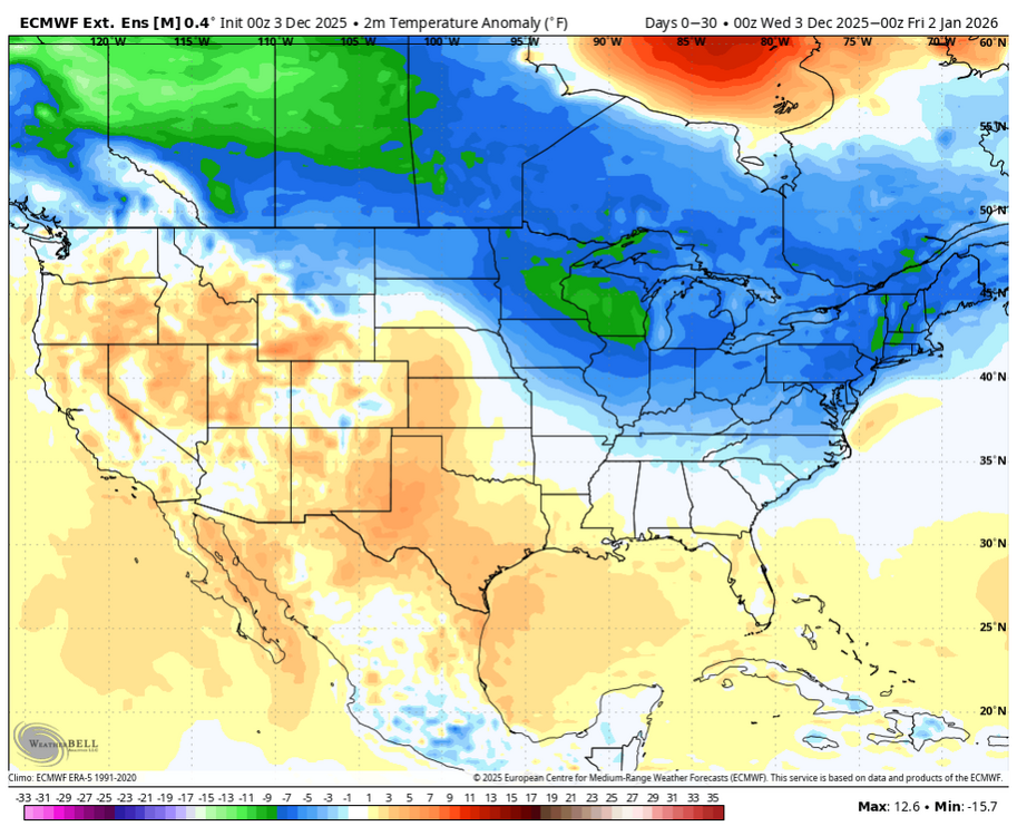
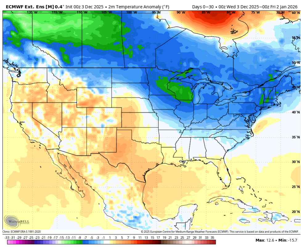
Like I’ve said in the past, it’s always good to see storms around the country in December but it seems like aside from the stormy start that just occurred. We will have the next 7 to 10 days of pretty much cold and dry over eastern and central US with nothing to show for it. Pre 2020 era, we would have ample snowstorms moving across the northern tier when you had such a cold weather pattern. But now everything ends up being suppressed and then when a storm amps up it ends up cutting or the southeast Ridge pushes it too far west for any of us to see the benefit. Welcome to the new normal.
-
December 2025 Short/Medium Range Forecast Thread
Carvers Gap replied to John1122's topic in Tennessee Valley
The 3k/12k NAM at 18z look decent for NE TN and SW VA. The 18z RGEM has not run for whatever reason. -
CAB is very very real and needs to end
-
It’s off the charts
-
Unfortunately, that’s not going to happen until we see some sort of big-time retraction of the Pacific jet, but that would require this summer temperatures over the north Pacific to not be super warm like they have been for the past seven years which leads to this faster pacific jet along the boundary with a colder Eurasia.
-
2/16-17 2003 I'm in Croton-on-Hudson and while I wasn't measuring at the time, there was definitely about 3 feet at my house.
-
No it did not and I appreciated the response
-
We'll be close to a 50/50 but the trajectory of the HP is a little south of ideal at Ogdensburg.
-
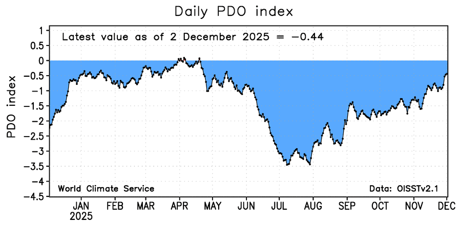
We’re ahead of last year wrt PDO…
-
I think we just follow the model runs way more closely during the cold months. In the summer, do we really care is a model says it is going to be 95 in 8 days and it turns out to be 88? Or if a model says 1.00" of rain and we get .4"? Unless I have outdoor plans, I rarely look at model runs from like April through October unless a hurricane is around the states. I know another board that tracks 100 degree days that the GFS and Euro models spit out per run for Philly. I think several times each year, models spit out record breaking 105 degree + days multiple times, and I think in 2024, the GFS spit out 100 or over for Philly over 100 different times, only too verify 0.
-
Not every situation follows that general rule. Several factors I weighted. I think the PDO is becoming more favorable and that matters more than an incredibly weak Nina. The fall pattern matched the snowier analogs I identified. We’re due.
-
Cold run. They get warmer in January