All Activity
- Past hour
-
Yeah, I change it for the day every year.
-

Storm potential January 17th-18th
dmillz25 replied to WeatherGeek2025's topic in New York City Metro

-
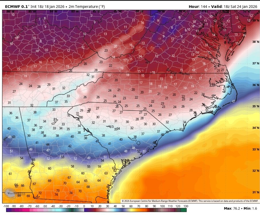
18z Euro temps at the beginning of the storm
-
Storm potential January 17th-18th
dmillz25 replied to WeatherGeek2025's topic in New York City Metro
If you use taptalk idk how it works but on the browser it does -
You keep starting the threads, SnowenOutThere, we WILL get a snow filled BECS in Feb or March. Or both.
-

Rise of the Machines: January 18-19 Winter Storm Obs Thread
Damage In Tolland replied to WxWatcher007's topic in New England
Ratios much higher in western areas. -
This echos my thoughts, same page. Increased chance of suppression based on recent runs bút still not the most likely outcome. Just can’t discount the idea right now
-

Storm potential January 17th-18th
Winterweatherlover replied to WeatherGeek2025's topic in New York City Metro
It's snowing, it's sticking it's winter like outside def will take it. Yesterdays snow was way more exciting though. -

Storm potential January 17th-18th
wthrmn654 replied to WeatherGeek2025's topic in New York City Metro
Doesn't for me lol -

January 2026 Medium/Long Range Discussion
Scarlet Pimpernel replied to snowfan's topic in Mid Atlantic
@stormtracker, will echo others and say I always like and appreciate your MLK avatar picture in honor of Dr. King each year! -
.3 final. Brings the season to a nice even 5.0”
-

Rise of the Machines: January 18-19 Winter Storm Obs Thread
moneypitmike replied to WxWatcher007's topic in New England
West of 395. -

January 16-18th: Rolling the dice
PrinceFrederickWx replied to SnowenOutThere's topic in Mid Atlantic
Final total: 0.3" on the snowboard. Roads and sidewalks didn't cave. On the board for January at least. -
I would love to get it to work because that drives me nuts. Just tried and I still can’t see locations???
-

Storm potential January 17th-18th
sussexcountyobs replied to WeatherGeek2025's topic in New York City Metro
Steady accumulating light snow. I'd say at least 3" new. 27.3° -
I like the 18z Euro(non AI) and 18z Euro AIFS EPS. The look almost identical. Ice to snow over NE TN. May even start as some light run. The AIFS EPS pushes the cold front in quickly as soon as precip starts. That cold air just crashes into the system.
- Yesterday
-
It's a classic setup for a widespread SE and/or MA winter storm. The snow stripe has potential to cover a lot of real estate. The 18z gfs left the key piece behind and that's still possible but it's also on its own right now. The gfs version would be a weak/sheared storm that could still hit the MA but big totals wouldn't be there. Suppression is a risk for sure and that includes my yard. The stronger the storm the less chance of suppression because it's hard to fight off a stronger storm from gaining latitude. Especially in the SE/MA. Imho, if the shortwave doesn't hang back like the gfs shows, there's going to be a nice event for the TN valley, SE, and MA. It will prob include a decent stripe of sleet and and freezing rain somewhere with the SE being favored. The all snow areas just to the north of the mix will do very well. Could be my yard, could be yours. Impossible to know that right now and not worth dissecting. Only thing we should care about is whether there is a solid cohesive storm coming or a weaker/sheared event. If it's a cohesive classic storm the MA would be all snow. I have a lot more mixing risk but walking that line is often one of the jack zones. I feel pretty optimistic about a fun storm that covers a lot of real estate but until we're inside of 96 hours, can't marry any idea. We could all get zero and NC south getting hit flush.
-
Can tell there is starting to be a real threat possibly of a major winter impact storm. Eastern valley is having to thread a needle potentially, so to speak...even 93 had to thread the needle.
-
And it’s on the weekend…which we’re really good at.
-

Storm potential January 17th-18th
Bxstormwatcher360 replied to WeatherGeek2025's topic in New York City Metro
Some good rates over nyc rn. Back edge still in eastern pa. I'd say another inch or 2 is possible. -
AI GFS and AI Euro did pretty good this week. They better not let us down next week.
-

January 2026 Short/Medium Range Thread
Holston_River_Rambler replied to John1122's topic in Tennessee Valley
FWIW here are the Euro AIFS ensemble member mslps at hour 144: -
Hard to accrete heavy ZR
-
Storm potential January 17th-18th
dmillz25 replied to WeatherGeek2025's topic in New York City Metro
You can see locations of posters when you do that -

Rise of the Machines: January 18-19 Winter Storm Obs Thread
CT Valley Snowman replied to WxWatcher007's topic in New England
Not impressed with the radar for those NW of 84.