All Activity
- Past hour
-

E PA/NJ/DE Winter 2025-26 Obs/Discussion
CoolHandMike replied to LVblizzard's topic in Philadelphia Region
Actually snowing right now. 29.3°F. -

White Christmas Miracle? December 23-24th
UnitedWx replied to Baroclinic Zone's topic in New England
I was thinking the same. We had 100 percent cover from the 2nd until the cutter. Better than most Decembers here by a lot -
 Had snow for a bit. rain and 34
 -

E PA/NJ/DE Winter 2025-26 Obs/Discussion
anthonyweather replied to LVblizzard's topic in Philadelphia Region
Lehigh county snow hole for this one… . -
We haven’t seen a clipper pattern like this in a long time. I am wondering if the benchmark KU track can become activated again at some point in January or February? That’s what we would need to get back closer to mid 20s seasonal snowfall.
-
It’s shredded
-

White Christmas Miracle? December 23-24th
CoastalWx replied to Baroclinic Zone's topic in New England
You mad? -
Euro and Euro AI unchanged
-
White Christmas Miracle? December 23-24th
UnitedWx replied to Baroclinic Zone's topic in New England
LOL. Well... it did just start snowing in Simsbury. -
Weird precip distribution Looks a bit south like the AI also
-
It starts too late so it dosent take advantage of colder air aloft Euro never snowed for you anyway Everyone jinxed it with the congrats Bob chill bs
-

December 2025 regional war/obs/disco thread
WinterWolf replied to Torch Tiger's topic in New England
that’s all we can ask for at 72 hrs out. -
Snow looks unlikely. Ice looking like a good bet.
-

White Christmas Miracle? December 23-24th
TalcottWx replied to Baroclinic Zone's topic in New England
Thank God Maine is doing well -

Central PA Winter 25/26 Discussion and Obs
Mount Joy Snowman replied to MAG5035's topic in Upstate New York/Pennsylvania
Welp I just drove through whiteout conditions on the way to the train and am currently stuck behind an accident on the backroads. Going to miss the first train. Roads were mostly fine but definitely some slick spots and deteriorating quickly. Stay safe out there! -
Wintry appeal at least.
-

E PA/NJ/DE Winter 2025-26 Obs/Discussion
KamuSnow replied to LVblizzard's topic in Philadelphia Region
In a lull here, 0.90". An overperformer! -
White Christmas Miracle? December 23-24th
CoastalWx replied to Baroclinic Zone's topic in New England
I guess around here it comes down to the inverted dong. To dong or not to dong, that is the question. -
6z Euro went the wrong way for Friday. Yesterday's 6z Gfs is looking like a blip. I just hope we can skip the zr and ip. Nothing exciting about spending Christmas weekend day inside.
-
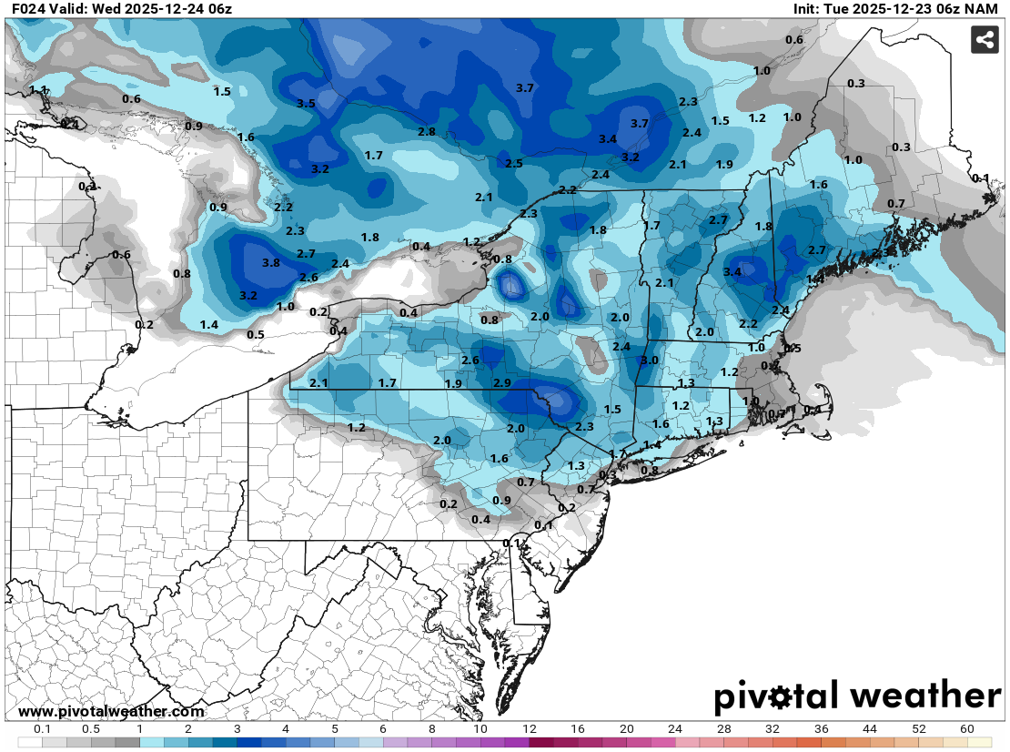
 Overnight, the NAM continued to trim snowfall amounts for New York City where a coating is far more likely than the NAM's earlier 2" amount. Checking historical data, the last time NYC saw 2.0" or more snow with a minimum temperature of 34° or above was January 23, 1966 (2.4" with 0.72" precipitation). The guidance showed < 0.25" precipitation. Aside from the above freezing temperatures, the light precipitation rate was also a "red flag." The last time New York City saw 2.0" or more snowfall with a low of 34° or above and < 0.25" precipitation was March 13, 1943. Then, 2.8" of snow fell with 0.23" precipitation and a low of 34°. The snow fell over a two-hour period with 0.16" of precipitation with a peak hourly amount of 0.11". The guidance showed peak hourly precipitation of 0.04" for the current weak system. As noted previously about snowfall with above freezing temperatures, in New York City, only 25.6% of storms have seen measurable snowfall with a daily low of 33° or above with just 9.2% seeing 1" or more snowfall. Almost three-quarters (74.4%) of such events have seen only a trace of snowfall. Put another way, more than 90% of such systems with snowfall at above freezing temperatures saw < 1" of snow. With low precipitation rates, the < 1" figure was the most likely outcome. Will that be correct? We'll know by this afternoon. Finally, 1"-3" well north and west of New York City still looks reasonable. Places like Binghamton and Middletown could see 3"-5".
-

December 2025 regional war/obs/disco thread
Sey-Mour Snow replied to Torch Tiger's topic in New England
6z euro came north a bit with the good stuff, gets all of SNE plowable like 00z .. -
Looks like an initial band tries to move north on 6z euro but then shredded out. Might be some OES on the coast with the cold and coastal front.
-
Not sure who deleted my maps @mappy but euro showed a pretty dirty wintry mix event
-

White Christmas Miracle? December 23-24th
Chrisrotary12 replied to Baroclinic Zone's topic in New England
Was focused on Christmas and fantasy football but have only been expecting flurries here. -

White Christmas Miracle? December 23-24th
The 4 Seasons replied to Baroclinic Zone's topic in New England
Steady light snow, roads are completely covered here. Hovering around 32.