All Activity
- Past hour
-
.thumb.jpg.6a4895b2a43f87359e4e7d04a6fa0d14.jpg)
Central PA Winter 25/26 Discussion and Obs
Yardstickgozinya replied to MAG5035's topic in Upstate New York/Pennsylvania
My mental image., was to blend the movie bloodsport with our forum snow contest but it ended up way too long of a story, but I kept a few elements. One of these days I finish it and put it up. -
The 12z Weather Next should be out in a few minutes.
-
Partially, yes.
-
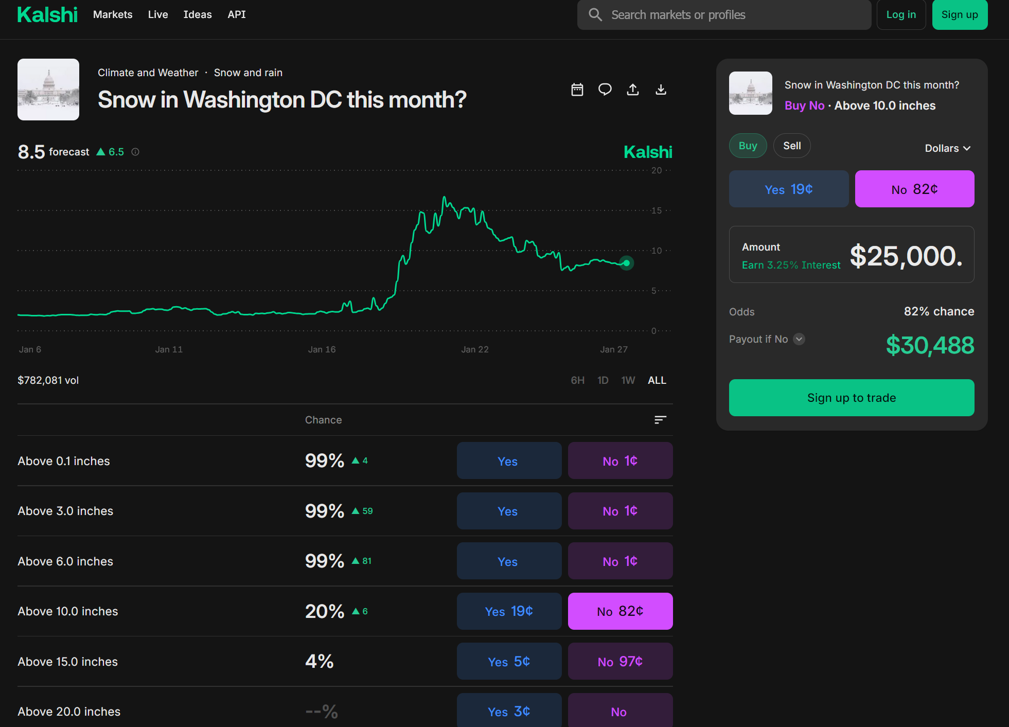
WTF, is this like a polymarket to trade weather forecasting?
-

January 2026 Medium/Long Range Discussion
Snowciopathic Snow Bro replied to snowfan's topic in Mid Atlantic
I'm curious when they'll initialize the new contract for February. Should be some fireworks there. -
WSSC advisory: https://www.wsscwater.com/news/2026/january/urgent-essential-water-use-only-request-issued-all-wssc-water-customers-due Still haven’t been plowed. This is going well.
-
Any GoogleAI updates for 12z and/or trends?
-
TBF, even in the most optimistic models, snow doesn't really hit the ground till after the turn of the month
-
Bruh we've gone 360 weeks with no snow....we can go hours.
-
Oh Bristow.
-

The “I bring the mojo” Jan 30-Feb 1 potential winter storm
greendave replied to lilj4425's topic in Southeastern States
we wait.
-
January 2026 Medium/Long Range Discussion
Snowciopathic Snow Bro replied to snowfan's topic in Mid Atlantic
The Kalshi prediciton market model says no big snow before end of month. DCA is the respresentative obs station, so good luck to all of the betting folks with that.
-

Winter 2025-2026 Offers Return to Normalcy
40/70 Benchmark replied to 40/70 Benchmark's topic in New England
Verification of High Impact & Long-Duration Sunday-Monday Winter Storm Strong Forecast Leaves Room For Improvement Overall the Eastern Mass Weather Final Call for the major winter storm that impacted the forecast area from Sunday through Monday verified quite well. However, the coastal front enhancement was somewhat misdiagnosed, as the front itself was pinned slightly closer to the coast than anticipated. The forecast for the front to penetrate into roughly the I 495 corridor was predicated up global guidance. But as it turned out, mesoscale guidance, which pinned the front closer to the coast, or along rt 128 and near I 95 on the north shore, proved to be more accurate. This is why highest amounts ended up along the coast (Gloucester, MA, 27"), (Ipswich, MA, 26"), rather than near the I 495 belt. Be that as it may, amounts of two feet, and event slightly more, were reported throughout much of northeastern Massachusetts, with a secondary on the east slope of the Worcester hills (Sterling, MA, 25.2"), as forecast. Final Grade: A -
Go check and let us know
-
Strong forecast overall yesterday, with the only glitch being that max amounts were a couple of inches higher and more along the coast than expected...in large part due to the fact that the coastal front ended up getting pinned a bit closer to the coast than I had thought. https://easternmassweather.blogspot.com/2026/01/verification-of-high-impact-long.html
-

Possible coastal storm centered on Feb 1 2026.
dryslot replied to Typhoon Tip's topic in New England
Yes, Only goes out to hr 87? But will they crush? -

Richmond Metro/Hampton Roads Area Discussion
wasnow215 replied to RIC Airport's topic in Mid Atlantic
EPS did come west some-North of say KD may be "game over" or close but we aren't in RVA, and those on here SE of us, Hampton, NN, Portsmouth, Va Beach, etc are squarely IN the game. Still 96 hours for changes to occur. -
At the end of its run, the RGEM looked like it was going to wind up similar to the GFS/Canadian.
-

Possible coastal storm centered on Feb 1 2026.
Typhoon Tip replied to Typhoon Tip's topic in New England
Heh... EPS mean shifted bodily SE ... consolidated at a deep pressure mean, too - it's not even in margin of error on that depiction - it's just flat bodily wrong, or, bodily right -
Central PA Winter 25/26 Discussion and Obs
Yardstickgozinya replied to MAG5035's topic in Upstate New York/Pennsylvania
Well i'm not so sure Blizz was flatterd . I'm sorry @Blizzard of 93 nothing personal dude I was just trying to make it as ridiculous as I possibly could. Boundaries are not my strong suit. I can tell you I had a f****** blast making it though. Especially when deciding what bllizard actually looks like . You guys might not find my jokes entertaining, but you ought to see me while i'm writing them. -
the lol didn't give away the sarcasm?
-

2025-2026 New England Snow Recordkeeping Thread
HoarfrostHubb replied to bristolri_wx's topic in New England
22" from Sunday/Monday 54" plus change for the season -
We just need the vort to wrap over West Tennessee vs East Tennessee. The Canadian and GFS do it there, the Euro isn't as wound up and brings it further East. The Euro Ai is closer to the Canadian/GFS than the OP Euro.
-
But sometimes when it wants to snow it does. With that said we've had misses before only to get hit a week later
-
It’s short notice, but does anybody on the eastern shore, have a good liquor store recommendation for whiskey along route 50 and 404?