All Activity
- Past hour
-

2025 Atlantic Hurricane Season
BarryStantonGBP replied to BarryStantonGBP's topic in Tropical Headquarters
Oh okay lad because I remember that nonce flooded up the Tube during my son's fresher's week while blasting reggaeton -
Boston has a decent shot of its third below normal August in a row. Now a winter month? augustuary?
-
You must be thinking of 2019’s Humberto. I’m referring to 2007’s, which hit upper TX/W LA.
-
It is REALLY impressive how we miss on days like the last two days. Almost a complete whiff at the farm too.
-

TROPICAL STORM ERIN - Expected upgrade to hurricane at 11
NJwx85 replied to BarryStantonGBP's topic in Tropical Headquarters
Another shift West with the 12z spaghetti models. They all now make it to at least 70 W before recurving. The vort that eventually kicks this out should be onshore tomorrow so hopefully the we’ll get a better consensus by Sunday. -
This isn't coming near the East Coast lol. If you want to talk about "how far west it can get" well maybe that's 70W or 73W and guess what happens if it makes it there...a sharp re-curve northeast. This was never going to be a "close call" for the coast. A storm coming into 70 or 75W and then sharply recurving isn't "close". If there was a weather pattern in place where there was room for a capture...then you could say close. Outside of a weather pattern to bring them up the coast they re-curve out to sea...that is the "climo". You can't call that close lol. Close implies there was a chance...there never was.
-
2025 Atlantic Hurricane Season
BarryStantonGBP replied to BarryStantonGBP's topic in Tropical Headquarters
I thought humberto went to canada and bermuda -
I actually saw the backside of the cell from a few miles east of Binghamton. The upper third was lit up by the sunset so I watched it for almost 2 hours until it got too dark. I caught up to it around Goshen.
-
 83 / 63 east / onshore wind
 -
September 2017 had an early cold shot, only to have the equinox have a high in the 90s. That following winter had an 80 degree day in February. At the time it was the earliest 80 on record.
-
You read way too much into my post. I simply stated it won't be classified as an official Niña, not that the consequences would be different with a different classification. As for the 1C° difference comment, a full 1C° does make a difference when you think about it if you compare the consequences of + or - 1C° anomaly to a 0° anomaly. So I think you meant a fraction of a degree Celsius.
-
In Jbenedet we trust
-
 True. The low departure on his graphics covered a large area, but having the 0 to -2 highs I think might have actually made it so I'm closer to -3 (for now) compared to north more where the departures were higher.
 -

Mountain West Discussion
mayjawintastawm replied to mayjawintastawm's topic in Central/Western States
Great and simple analysis. I'm guessing the moisture trends are messier but summers certainly seem to have dried since we moved here in 2010. -
Haven't hit 90 here either but I'm on the shore, inland did a couple of times.
-
The other is that Tamaqua won't...lol
-
I honestly stay hope he’s kidding because it’s cringe worthy.
-
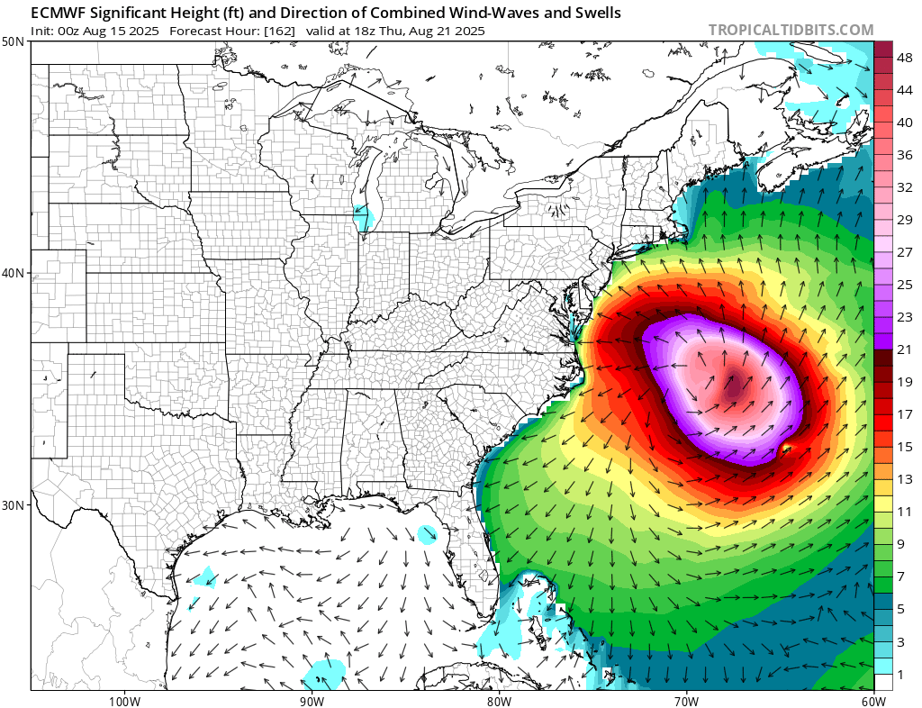
 Next week looks like what the surfers have been waiting for all summer. The best August hurricane swell that we have seen in years. The unusual part with the set up is how much smoke pools just to our SW as the Erin recurves OTS. So rather than much rain, we could see the smoke move into the area as Erin phases with the 50/50 low and another upper low from Hudson Bay heads for SE Canada. https://atmosphere.copernicus.eu/charts/packages/cams/products/aerosol-forecasts?base_time=202508150000&layer_name=composition_aod550&projection=classical_north_america&valid_time=202508200000

-
 If I go by Central Park's average for my location, which is probably more in line since its numbers are cooler overall than the more urban spots of the city, the closest ambient station to me is -3.5 degreess so far for the month.
 -
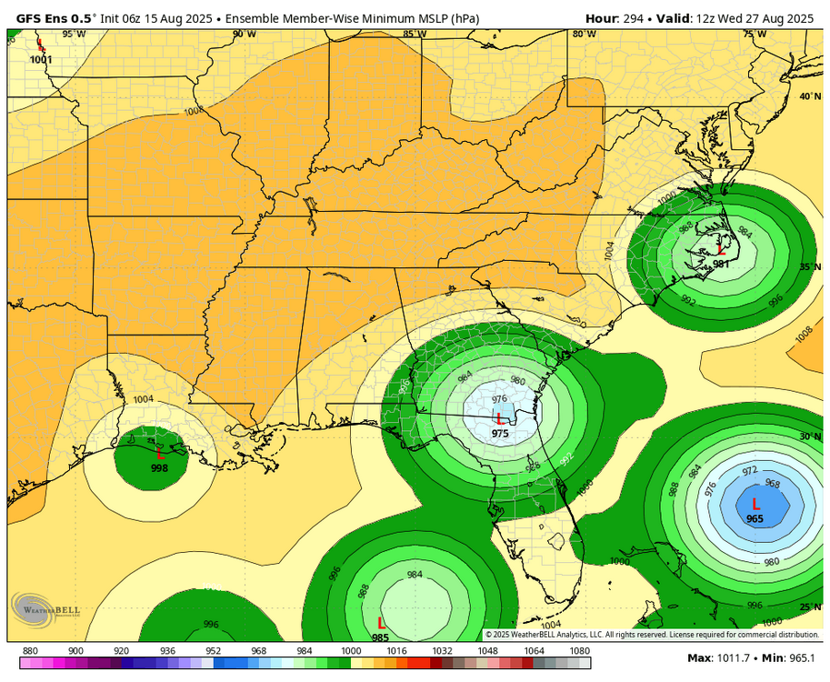
-Just for the record fwiw, the 6Z GFS hits Daytona on Aug 29 (way out at 2 weeks) -Much more statistically significant than just a fantasyland op run, its ensemble is unsettlingly pretty active in/near the SE US during Aug 26-30. Here’s a snapshot as of hour 294 (12Z on 8/27): -During this active period, GEFS has the MJO in/near phase 5. It’s not either of the 2 most active phases for H hits per day during Jul-Sep since 1975 (phases 2 and 8), but phase 5 has had the 3rd highest ratio of hits/day. - During phase 5, these 10 Hs hit the Conus: Francine (2024), Ike (2008), Humberto (2007), Ophelia (2005), Isabel (2003), Bertha (1996), Fran (1996), Bob (1991), Elena (1985), and Babe (1977). Two areas were most impacted by these 10: NC (Ophelia, Isabel, Bertha, Fran, and Bob) and upper TX to FL panhandle (Francine, Ike, Humberto, Elena, and Babe).
-
8" here over the same period. Feast or famine.
-
-
Lloyd Christmas likes it's chances
-
Not you lol.