All Activity
- Past hour
-
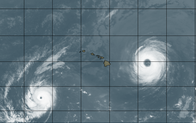
The HI area has some sig activity 1993 and 1994. Polar image attached from Aug 15, 1993, showing annular HU Fernanda to the E and HU Keoni to the SW. And in 1994, the CPAC was very active,. HU Emilia became the strongest CPAC HU (140 kt) up to this time in mid July. Then a week later Gilma attained peak intensity roughly the same as Emilia in the CPAC. Then in Aug, HU John peaked at 150 kt to again break the CPAC record for the strongest storm, and became the longest- lived TC globally until 2023. The three Cat 5s in 1994 all passed well S of HI, so no direct impacts, but to have that kind of activity is remarkable. SSTs were running about 2.5 C above avg in the region as mdt El Nino was in taking shape. Another item that stood out during this time was a very large area of dry air on WV in the central southern Pacific in the tropics/subtropics, so subsidence here implies rising motion synopticly on the other side of the equator in at similar latitudes.
-
Like I said...everytime we have something good, smh We'll see him in who knows how many weeks! And our next man up isn't much in the WR department--we're gonna have to sign somebody with Zay being iffy (you see how pedestrian the offense looked when he left) Otherwise the offense is gonna be a concern.
-
It’s going to be one of those years where we push this heat well into October and when the flip happens, it happens fast. Regime change meets active southern jet and suddenly you go from 80s/90s and dry to 50s and rain. I’m not saying it’ll be an early kick off to winter, but I wouldn’t be shocked if come Halloween, it feels more like late Nov/early Dec with no warning.
-

Septorcher 2026 Discussion - Endless Summer
40/70 Benchmark replied to Damage In Tolland's topic in New England
Who doesn't? -

2026 Atlantic Hurricane Season
vortex95 replied to Stormchaserchuck1's topic in Tropical Headquarters
And to round things out about trends in TCs,.one item that seems to have slipped under the radar since so much focus on the very active Atlantic in recent years, for the NW Pacific, 2020-2025 was below average ACE each year, as low as 51% for ACE in 2020. In fact, the total ACE for this 6-year period was only 66% of average, which is the lowest 6-year ACE on record for this basin going back to 1950. https://tropical.atmos.colostate.edu/Realtime/index.php?arch&loc=northwestpacific Given our detection and documentation of TCs is better than ever these days, this makes this record more impressive. Since the NW Pacific accounts for about 38% of annual global ACE (more than twice any other basin), this quite significant overall when talking about trends. The notion that when the Atlantic is active, the NPAC is not, seems to be still holding true overall. And we see this year w/ the Atlantic suppressed, and the NPAC is very active. -

Central PA Summer 2026 Discussion/Obs Thread
Itstrainingtime replied to Voyager's topic in Upstate New York/Pennsylvania
I'm really not interested in throwing anyone under the bus. I want to make sure that I'm handling myself appropriately. It's just hard knowing that stuff is going on that while not directed specifically at me, it's obvious that I'm the target. I only said what I said to explain why I don't say much anymore. Don't really wish to offend. -
Central PA Summer 2026 Discussion/Obs Thread
Itstrainingtime replied to Voyager's topic in Upstate New York/Pennsylvania
Sports threads. -
2026 Atlantic Hurricane Season
vortex95 replied to Stormchaserchuck1's topic in Tropical Headquarters
Attached is a paper about change of power dissipate index (PDI) for the South Indian Ocean since the 1990s. It also shows a map of trends in all tropical basins. A significant decrease in power dissipation index has been detected in the South Indian Ocean basin since 1994, which is almost entirely due to a decrease in both tropical cyclone frequency and duration in this basin. The decrease in tropical cyclone frequency is influenced by increased atmospheric stability. The decrease in tropical cyclone duration can be attributed to the changes in tropical cyclone locations. So the decrease is due to a decline in frequency and duration, noting about absolute peak intensity. And if you look at the all basins combined the PDI trend is down. Why 1994? Well, two reasons I think this was picked. One, full geostationary converge did not exist for the Indian Ocean until 1989, and many TCs prior to that we way underdone for intensity. Yes, we have polar imagery, but the delay to transmit those images to TC centers was delayed by several hours in those days, and could not be used operationally. Second, 1994 was the last year in a quiet period for the Atlantic that started in 1970. It also marked the end of an overall active period for the NPAC. The AMO flip occurred around this time, so it appears that there could be TC basin impact globally from the AMO cycle. The Southern Indian Ocean contributes the second most annual ACE of the TC basins. tcpaper.pdf -
 online generic medicine india or indian pharmacy online lowest price e pharmacy india http://www.hyoito-fda.com/out.php?url=http://indiagenericstore.com all generic medicine india and https://www.trendyxxx.com/user/hmtdbfsemz/videos all generic medicine india [url=https://www.google.sr/url?sa=t&url=http://indiagenericstore.com]indian pharmacy official website[/url] online medicine shopping or [url=http://lenhong.fr/user/bbalovnpon/]buy medication online[/url] buy medicine from india
 -

2026 Atlantic Hurricane Season
ensonerd1233e343 replied to Stormchaserchuck1's topic in Tropical Headquarters
also 1973 47 ace -
Perfect weather for the first NFL Sunday. Was stuck in the 50s all afternoon with passing showers. Did manage 0.08" here.
-
http://indiagenericstore.com/# order medicine online india
-

Central PA Summer 2026 Discussion/Obs Thread
Blizzard of 93 replied to Voyager's topic in Upstate New York/Pennsylvania
What other threads has this been happening in recently? -
Lots of spots should see their first 40s across the far northern/NW burbs in IL Pretty ideal conditions to bottom out with light wind and clear skies
-
Lots of spots should see their first 40s across the far northern/NW burbs in IL Pretty ideal conditions to bottom out with just a gentle wind and clear skies
- Today
-
Bears big win, Packers lose, windows open weather? Perfect day.
-
best mexican pharmacy for prescriptions and mexico medicine best mexican pharmacy for prescriptions http://www.kinderverhaltenstherapie.eu/url?q=https://mexicogenerics.com mexican pharmacies that ship and https://www.0468wudi.com/home.php?mod=space&uid=276256 is mexican pharmacy store legit [url=http://www.raphustle.com/out/?url=https://mexicogenerics.com]mexican pharmacy order online[/url] largest online pharmacies in mexico and [url=https://4k-porn-video.com/user/eblhjtsqfq/]mexican pharmacy for hair loss pills[/url] mexico pharmacy order online prescription
-
2026 Atlantic Hurricane Season
vortex95 replied to Stormchaserchuck1's topic in Tropical Headquarters
It's definitely among the most fascinating microcanes. Does anyone remember Iris? That's my all-time favorite. Iris among the smallest eyes on record and triple concentric eyewalls at one point near landfall! -
Central PA Summer 2026 Discussion/Obs Thread
Itstrainingtime replied to Voyager's topic in Upstate New York/Pennsylvania
I offended someone with my Day In the Life post and since then he takes shots in other threads. -

2026-2027 Fall/Winter Mountain Thread
Met1985 replied to BlueRidgeFolklore's topic in Southeastern States
Looks like the heat is going to stay with us until the end of the month. -
You can say that again. 87-88 was a small tease. 92-93 was total joy after a decade of mostly suffering
-
Better than nothing. I am probably 5 miles North and east of downtown
-

Septorcher 2026 Discussion - Endless Summer
CoastalWx replied to Damage In Tolland's topic in New England
bow down -
Posting the alleged new CFS DJF snowfall map for the laughs. If this somehow happened I'd probably be happy. It would be the first above average seasonal snowfall I've had in a decade.
-

Septorcher 2026 Discussion - Endless Summer
Ginx snewx replied to Damage In Tolland's topic in New England
At least we have weather stations.