All Activity
- Past hour
-

December 14th - Snow showers or Plowable snow?
HoarfrostHubb replied to Sey-Mour Snow's topic in New England
I’m pulling for the southern folks. -
It’s unfortunate we melt it all later this week but I still think the 21-24 or so offer a chance or two.
-

Saturday night/Sunday 12/13-12/14 Jawn
Newman replied to Ralph Wiggum's topic in Philadelphia Region
1am sounding for Allentown off the 3k, wow! Plenty of ascent right in the DGZ. The 10pm - 3am timeframe will probably be when the LHV gets the best rates before everything shunts southeast. Snow might be done by sunrise tomorrow morning.thumb.png.15039e680f80f47d90cace2746488a16.png)
-

December 14th - Snow showers or Plowable snow?
CoastalWx replied to Sey-Mour Snow's topic in New England
Wow decent trends overnight. Would be great to get 1-2 here. -
Stop trying
-
I hope we all do but I really hope those who have bare ground get some. Tis the season.
-
"Two houses up" can be quite different here than in your area. For instance, for me "two" houses up in one direction is half a mile, in the other direction it is 4 miles.
-

December 2025 regional war/obs/disco thread
Damage In Tolland replied to Torch Tiger's topic in New England
Some warmth aloft -

December 2025 Short/Medium Range Forecast Thread
Carvers Gap replied to John1122's topic in Tennessee Valley
I don't have a lot of time this morning. A trend worth watching...overnight and morning deterministic runs (CMC, Canadian para, 6z AIFS, and 0z Euro) continue to erode the warmup. That doesn't mean we won't see warm air masses, but go look for yourself. They have, even the gfs, found the Dec 20th cold front. This really looks like more of a back-and-forth pattern where warmth surges, cold erodes it quickly due to the cold source, and wash/rinse/repeat. Ensembles aren't there yet, but at this range...they will wash out any trends. -

12/14: Sunday funday? Will the south win again?
Solution Man replied to TSSN+'s topic in Mid Atlantic
Hoping for a few mangled flurries -
Saturday night/Sunday 12/13-12/14 Jawn
Newman replied to Ralph Wiggum's topic in Philadelphia Region
6z Euro is quite a bit more wet for the Lehigh Valley. Solid 2-4", many of the mesos are also bringing WWA amounts north. Should be a solid event for the area. -

December 14th - Snow showers or Plowable snow?
Great Snow 1717 replied to Sey-Mour Snow's topic in New England
Gotta love the big "0" right over the Winter Wonderland aka Rainthuen...lol -
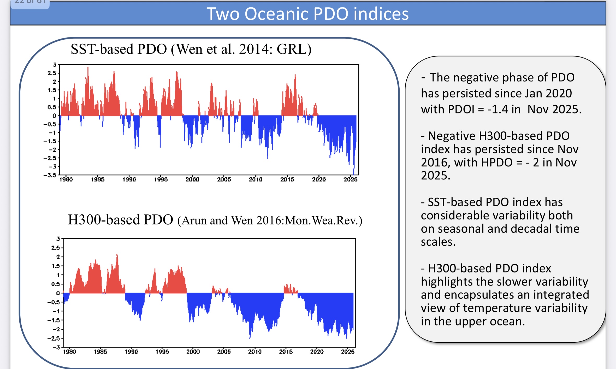
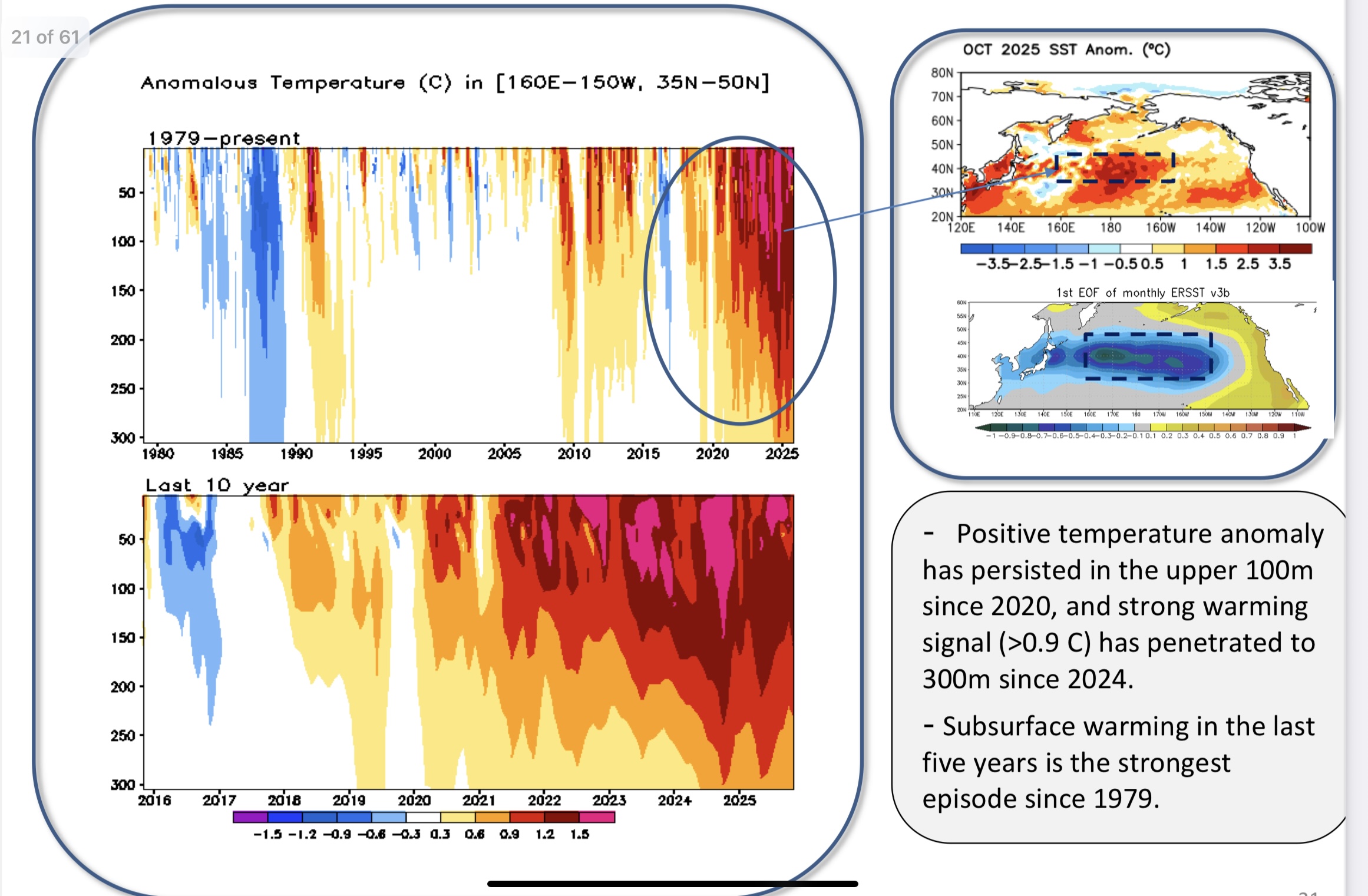
The H300 PDO finished November at -2.0 due to how extensive the subsurface warmth is. https://www.cpc.ncep.noaa.gov/products/GODAS/ocean_briefing_gif/global_ocean_monitoring_current.pdf


-
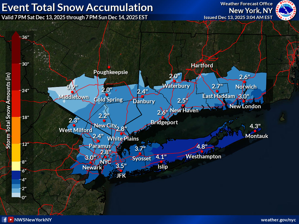
3am update from NWS. A little more snow on the south shore of NYC and Long Island .

-

December 14th - Snow showers or Plowable snow?
Ginx snewx replied to Sey-Mour Snow's topic in New England
2 to 4 covers it lollies to 5 -
Eps fwiw
.thumb.png.6f79a4dcc08990af3b8b8ef1a1a344cf.png)
-
If they’re showing that a White Christmas is on the table, then yes I’m very interested.
-

December 14th - Snow showers or Plowable snow?
Baroclinic Zone replied to Sey-Mour Snow's topic in New England
Yeah, that and the RRFS are on the “juicer” side, so we monitor today’s runs to see if we uptick some or stay the course. Most modeling has 0.2” up to around my area. -
December 2025 regional war/obs/disco thread
Ginx snewx replied to Torch Tiger's topic in New England
Looks like prolonged snow -

December 14th - Snow showers or Plowable snow?
ineedsnow replied to Sey-Mour Snow's topic in New England
It would be nice to get a inch or two of fluff here.. but this looks mainly south.. congrats to the ones who haven't seen snow yet!! -
Beautiful sunrise. Red sky in the morning, a sailor's warning. Definitely has that "it's gonna snow" feeling in the air
-
Still expecting 1” only. Boom is 2, bust is flizzard
-

December 14th - Snow showers or Plowable snow?
SouthCoastMA replied to Sey-Mour Snow's topic in New England
Euro AI juiced up the last two runs. .5 up to Taunton -
December 2025 regional war/obs/disco thread
Damage In Tolland replied to Torch Tiger's topic in New England
Xmas week look on all modeling has icestorm written all over it. Frigid SE Canada with waves running along boundary south -
December 14th - Snow showers or Plowable snow?
Damage In Tolland replied to Sey-Mour Snow's topic in New England
Turning into 2-4” from 90 south

.png.f07c2ebea5f340a7ca20012952e6e770.png)


.png.edcf3f9b730ea3a1162939f59e5cb768.png)


.thumb.jpeg.f5c6ba9d911ec96b3b124f8606aee58e.jpeg)

