All Activity
- Past hour
-

“Cory’s in NYC! Let’s HECS!” Feb. 22-24 Disco
RUNNAWAYICEBERG replied to TheSnowman's topic in New England
Go for it. -
So impressive! The 18z HRRR has a 3-5% chance of lightning (throughout the entire atmosphere) for Providence from 12am-3am on Monday.
-
lol
-

2/22-23 "There's no way..." Storm Part 2
DDweatherman replied to Maestrobjwa's topic in Mid Atlantic
It is back, better than 12z, by 0z it might be back to a banger. -
Shot hoops earlier and was schvitzing a bit after only a few minutes. I can sense a snowstorm is on its way.
-

“Cory’s in NYC! Let’s HECS!” Feb. 22-24 Disco
weatherwiz replied to TheSnowman's topic in New England
GFS pretty steadfast at 18z...excellent to see. -
GFS is an absolute beatdown out here. Every single model has us getting the inverted trough goods now. Looks amazing.
-
Not going to get dry snow with temps in mid 30s
-
Fan of it?
-
It is stronger than the 12Z
-

Blizzard of 2026 Storm Thread/OBS
Hurricane Agnes replied to Mikeymac5306's topic in Philadelphia Region
I'm an early bird and checked in here this morning around 3 am and saw there had been 73 messages posted since last night. -

E PA/NJ/DE Winter 2025-26 Obs/Discussion
Ralph Wiggum replied to LVblizzard's topic in Philadelphia Region
Euro has a march 2-3 two-part winter storm -
GFS not backing down. Pretty much the same as 12z
-

Blizzard of 2026 Storm Thread/OBS
BroadWing3544 replied to Mikeymac5306's topic in Philadelphia Region
Even if it is the (Mt. Holly) 10% probabilistic map, seeing totals near the big 3-0 around the Philly area is pretty staggering. -
Feb 2013 (nemo) for suffolk county. Had 30 inches and constant thundersnow. I compare all storms to that one out here. More intense then 96 for me.
-
Swoon
-
Wow. What a headache for @MillvilleWx
-
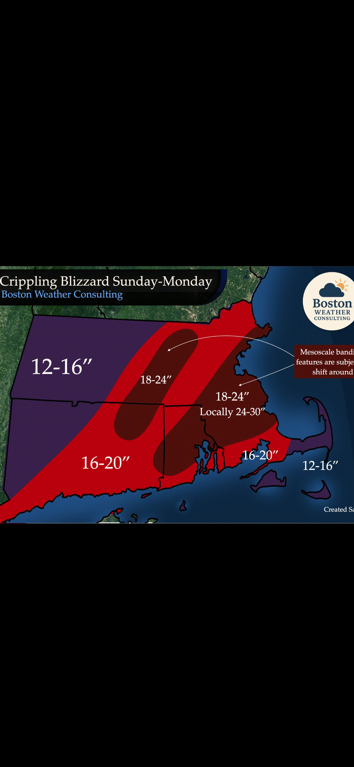
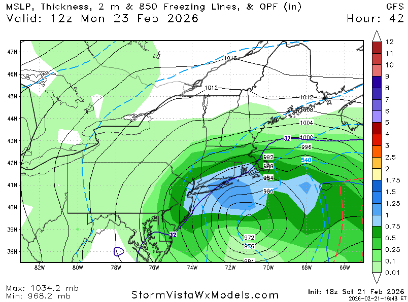
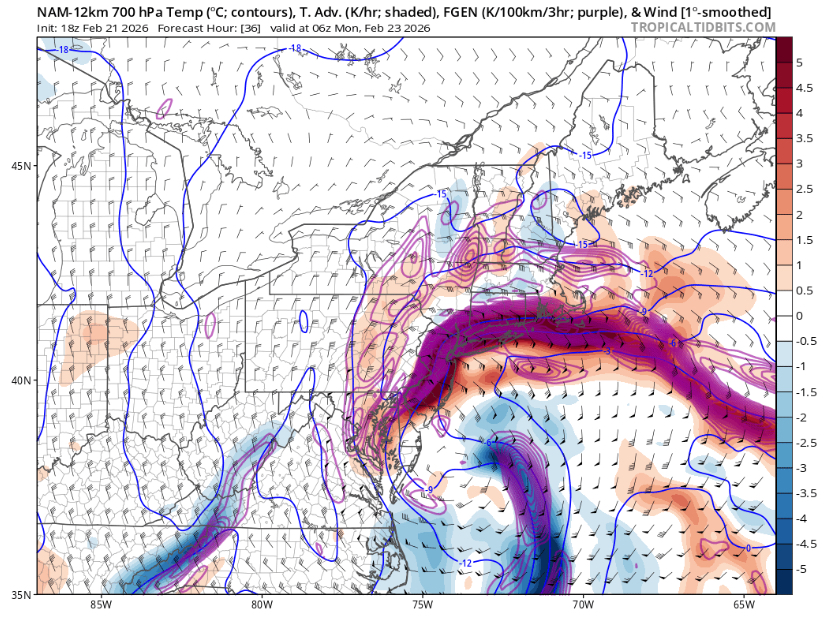
NAM FGEN Sunday night. Damn!
-
sorry, i meant 12z
-

“Cory’s in NYC! Let’s HECS!” Feb. 22-24 Disco
Damage In Tolland replied to TheSnowman's topic in New England
BWC?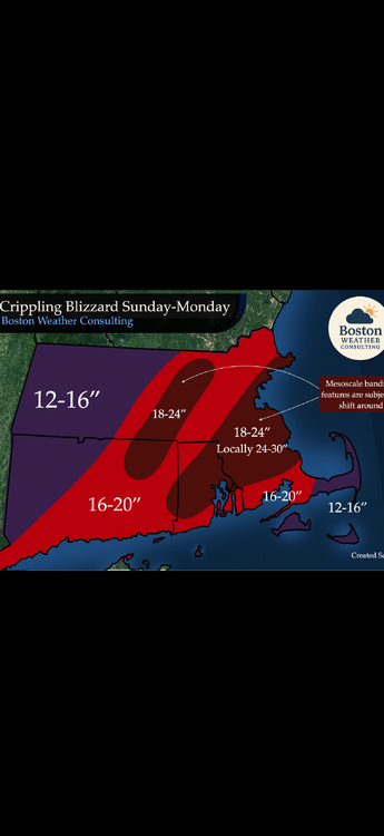
-
a lot of the big ones are prefaced like this. Beautiful day here in DC - mid 50s, sunny.
-

“Cory’s in NYC! Let’s HECS!” Feb. 22-24 Disco
Typhoon Tip replied to TheSnowman's topic in New England
Completely agreed here. I mentioned this either last night or the night before, when the ensemble means were down to 522 dm at 84 to 90 hours lead! Historic events are typically not seen in the mid range. More often than not - though yes there are rare exceptions - your plotting a major with very impressive parametrics, and then it goes out of control almost during now cast and bests even the outlooks. 1993 and 'Sandy' are examples of notable exceptions. This one has been suggesting history for since about 48 hours ago, when it was just one or two outliers going bonkers. Now it seems there are less conservative model visions than going the other way. So I dunno. going to be an interesting event -
Blizzard of 2026 Storm Thread/OBS
Ralph Wiggum replied to Mikeymac5306's topic in Philadelphia Region
ICON is a decent 4-8" for the region. I mean, its wrong but any other time we would be thrilled! -

“Cory’s in NYC! Let’s HECS!” Feb. 22-24 Disco
moneypitmike replied to TheSnowman's topic in New England
Not quite sure why GYX has put a watch up—maybe just to make me feel better -
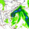
SPC AC 211725 Day 2 Convective Outlook NWS Storm Prediction Center Norman OK 1125 AM CST Sat Feb 21 2026 Valid 221200Z - 231200Z Across the Carolinas, mid Atlantic and southern New England coasts, intense surface cyclogenesis will support very strong low-level warm advection. The strong ascent may result in enough elevated instability (100-200 J/kg) and intense precipitation rates to support a few lightning strikes within the warm conveyor belt of the Nor'easter as the low lifts northward along the coast Sunday night into early Monday.