All Activity
- Past hour
-
the Pope laughs at your forecast, your blog spot, and of course, at you.
-
Logic... not a favorite theme here at times
-

Winter 2025-26 Medium/Long Range Discussion
michsnowfreak replied to michsnowfreak's topic in Lakes/Ohio Valley
Theres a large pile at the mall here. That will be here all winter. But the rest, stay tuned lol. -
You're welcome - glad the info was helpful. I'm kind of a nut about measuring accurately.
-
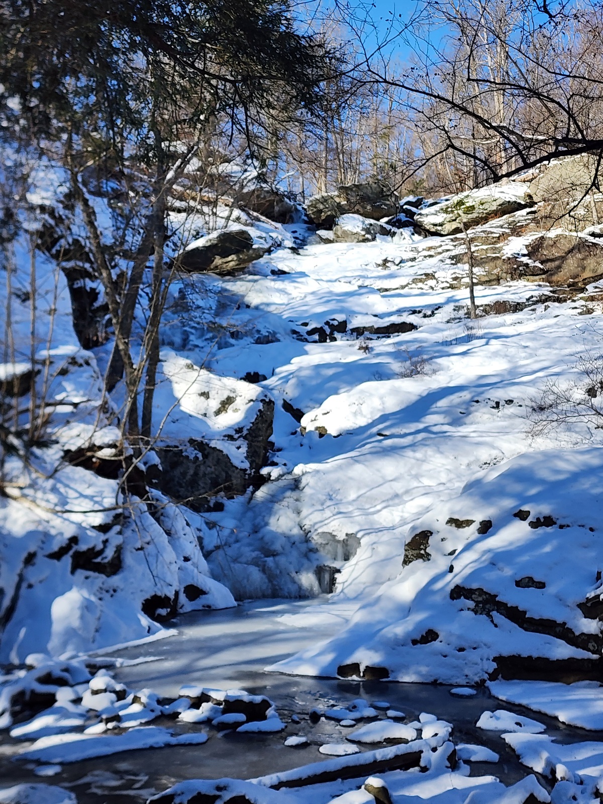
I drove out to Cunningham Falls this morning for a day of hiking at higher elevation. It wanted to extend the deep winter period one more day by headed out there. It was an interesting drive out there. The snow distribution from here to there was super spotty. As soon as I got on 97 north from Crofton the snow really thinned out. It didn't increase again until I got up on 70 and got into higher elevation. Once I got into the Frederick valley it got super thin and spotty again. As soon as I gained elevation going up into the mountains it increased again. Their was about 4" of powdery snow up at the fall. The falls are at like 1200'. It was 27 at that elevation. I hiked up to 1500' and suddenly it was above freezing up there. It was colder in the low spots between ridges. The falls were completely frozen.
-

Winter 2025-26 Medium/Long Range Discussion
frostfern replied to michsnowfreak's topic in Lakes/Ohio Valley
I think I will still have snow *banks* even if grass is mostly visible. Also got a pile around 20’ tall at the local mall. Got to plow that sucker for the people doing donuts every Saturday night. -
I realize I used to be real awful at times. Somehow after the 3 years of zeroing out I have chilled out a lot more lol. As for he upcoming pattern I know it sucks to warm up during Christmas but we know the cold can't hang on around here for the entire winter. If we can flip back for January that would be fine with me to get back in the game and hopefully real one in south of Virginia for once.
-

December 2025 regional war/obs/disco thread
Damage In Tolland replied to Torch Tiger's topic in New England
EOR -

December 2025 regional war/obs/disco thread
weatherwiz replied to Torch Tiger's topic in New England
yeah eastern areas def have greatest potential to get temperatures well into the 50's and some stronger wind...perhaps even some convection too -
Friday could rip especially in ern areas. You’ll have some daytime heating ahead of rain
-
Yea. I just don’t remember those storms as I was living in Seattle part of the time and missed them. GHDI was better here in GRR (though still a little short of the forecast with 15” verified as opposed 18” forecast) while GHDII was more concentrated along I-94 with lighter totals north (8-12”).
-
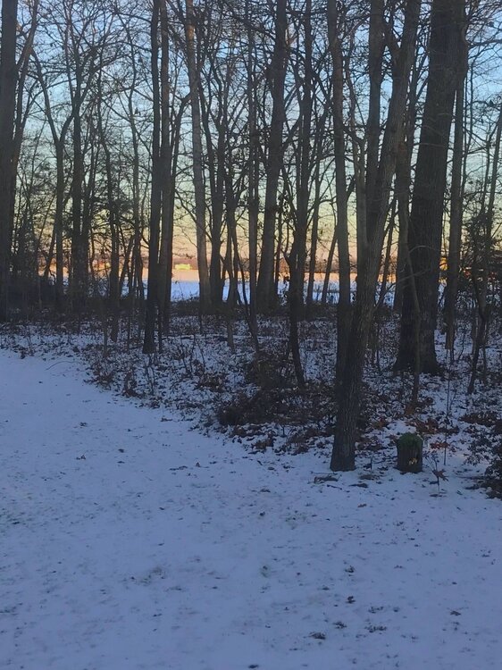
31 at 4pm. This view will be gone in the next 24 hours, but nice while it lasted.
-
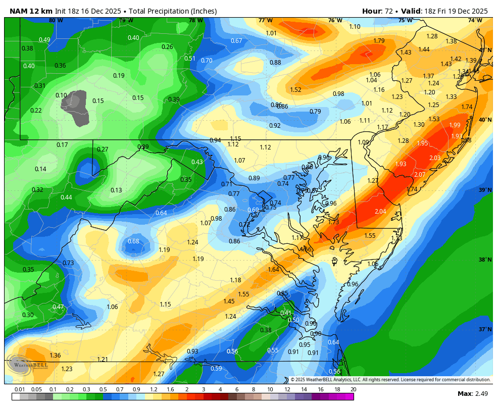
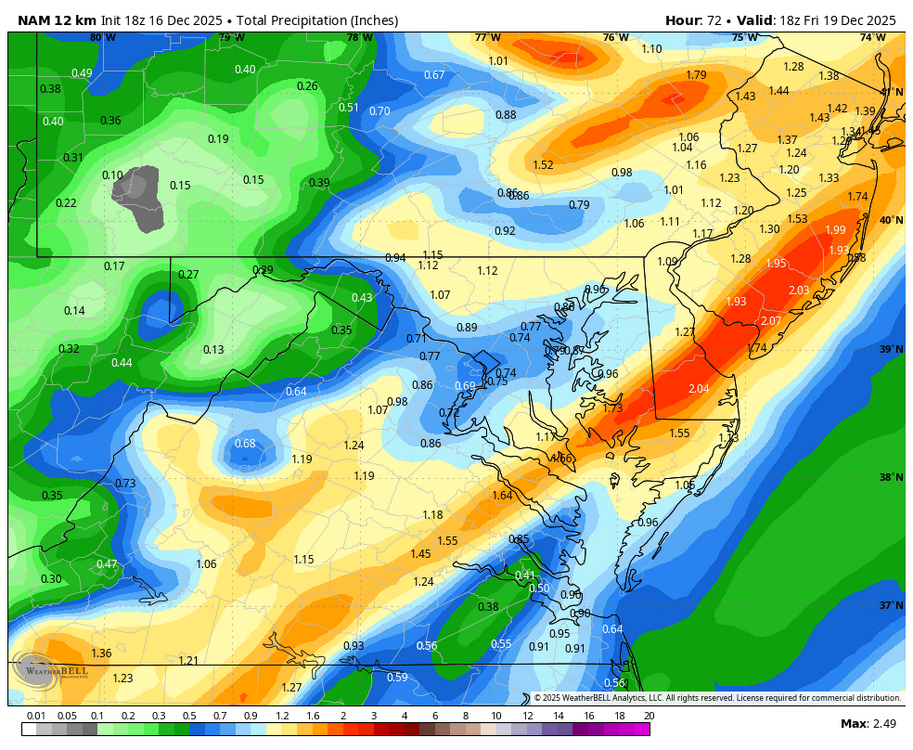
18z NAM and ICON trend wetter for WOTBR for Thursday night. Hopefully, this is a trend toward more precipitation to alleviate the drought.
-
2025-2026 ENSO
michsnowfreak replied to 40/70 Benchmark's topic in Weather Forecasting and Discussion
After the holiday mild period, will be interesting to see if Jan-Feb takes on a classic nina like roller coaster pattern. With plenty of cold in Canada and plenty of warmth to the south, that may just be in the offing as we head deeper into winter. -
I didnt say he isn't, just pointing that out. GHD1 was still a big storm here...it just failed to reach expectations in SE MI. Actually boggles my mind that this bust is still talked about with everything thats happened in the 15 years since. Its not like we expected 3 feet and got 0, we expected 12-18" and got 8-11" GHDII (16.7" DTW) and Jan 22 2005 (12.2") were huge storms at Detroit with plenty of arctic air around...to say nothing of the insanity of Jan 6, 2014. Following nearly 11" of snow temps dropped to -14° in hours.
-
Southern is an OK forum, I post occasionally, but I cannot stand the look and feel of the site. It’s brutal to me. There are good posters there and a lot of folks who post in both but I too wish we could get some back who’ve left here. It’s quite the spectacle to go over there if Raleigh is getting screwed by a storm. If you think the Raleigh folks here are bad it’s even worse there. They have a lot of Charlotte posters too which I appreciate as someone who lived there for a long time after college
-

Pittsburgh/Western PA WINTER ‘25/‘26
colonel717 replied to Burghblizz's topic in Upstate New York/Pennsylvania
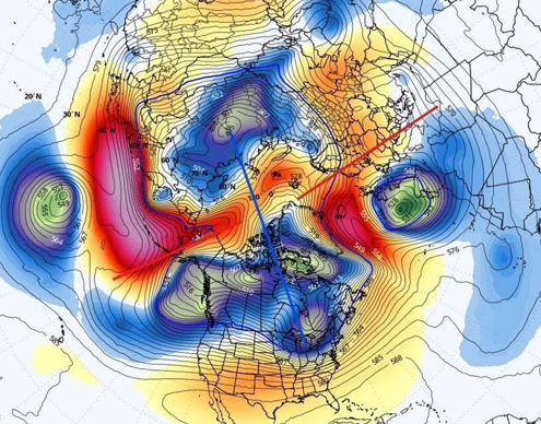
From Ohio Valley Weather Center: [Tue 12/16/25 215pm EST] Today I will focus on the upper-level pattern at 500 mb (18000 feet). While there is some let up, focus on the 500 mb heights. Notice the tendency for higher heights to start building up into Alaska and slowly spreading into Greenland. Here is the caption for Friday morning. Notice the dive of colder air into the area, whereas just a handful of days ago, this was not shown. Models missed this. (Inage 1) Notice another piece coming in for Sunday into Monday. A lobe of cold comes through. Another instance where the model missed this a few days ago. Now, it seems to be sensing colder air. Again, higher heights into Alaska and NW Canada and up into Greenland, a bit. By no means, perfect, but modest enough to dump a batch of cold air in the region, again. (Image 2) So, assuming models will indeed miss Friday and catching on now, then missing another piece Sunday/Monday, it is hard to trust models past a handful of days. So, while it will not be as cold over the next week to ten days, if models are struggling in the medium range, there is no reason to trust models past 6 or 7 days. The tendency is for the model to keep the vortex stretched across Canada and central and eastern Russia, which implies colder air to spill into the central and east. I believe the models are mishandling things, and each subsequent run, the models slowly catch something and once inside 3 or 4 days, you see the change.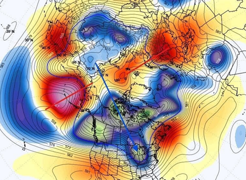
-
Winter 2025-26 Medium/Long Range Discussion
michsnowfreak replied to michsnowfreak's topic in Lakes/Ohio Valley
White Christmas looking unlikely. Bummer, but we've had snowcover the entire Christmas season to now, so thats been nice. After the holiday mild period, will be interesting to see if Jan-Feb takes on a classic nina like roller coaster pattern. With plenty of cold in Canada and plenty of warmth to the south, that may just be in the offing as we head deeper into winter. -
He’s still wrong though. GHDI was on the heels of prolonged cold. Maybe that one wasn’t so good for SE Michigan, but the problem wasn’t too much cold.
-
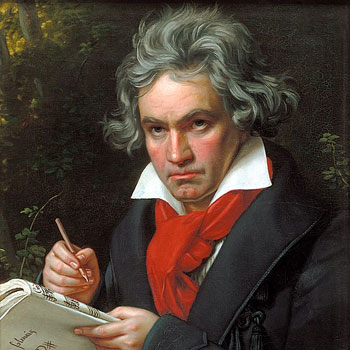
Uh-oh...guess what day it is? Guess what day. It. IS? Man this oughta be a global holiday On this day 255 years ago, the most consequential figure in the classical-romantic era was born in Bonn, Germany. The great Ludwing Van Beethoven...one of the greatest composers that ever lived. No composer singlehandedly brought about a new era of music quite the way he did. Beethoven was always a fiercely independent and determined man, and burst forth onto the music scene first in Bonn, and then in Vienna. He was a brilliant virtuoso whose talent quickly reached wide accalim. The musical world increasingly at his feet. But then...the malady that was so crushing hit him. BUT...after a near-death struggle coming to terms with his incurable deafness, Beethoven came out with a new determination: To express all the music that was within him. And he was determined to make music on his own terms. Because of the crushing affliction of gradually increasing deafness, among other trials, struggle and triumph permeate his music. And perhaps it is for this reason that his music still resonates so much today. His music was the raw expression of the human soul; all of it! And could this expression be fit into a musical box? It could not! Someone had to come along and open the door; and Beethoven not only opened it, he broke the whole wall down. No longer confined within certain walls, classical music was expanded to fully express what's in the soul. But in order for this to happen, somebody had to It is almost as if his struggle with deafness and a couple other physical afflictions. was the very thing that helped create the revolutionary music; that, combined with his sheer determination and fire, created music that forced the door open. As one documdrama ("The Genius of Beethoven") put it: With Beethoven, "music grew up". Everything Beethoven did tested the limits of instruments, musical form, and the very performers themselves. How things were done before could not contain Beethoven's music! His "new way", as he termed it coming out of his battle with accepting deafness, continued for the rest of his life...and gave birth to an entirely new era of music known as the Romantic Era. I could say so much more, but...his music touches me in a way nobody else's does. My soul identifies with Beethoven, and his music gives me thrills so much that anyone that knows me knows how I move when I hear any Beethoven work! He is the composer I revere the most--and I thank God for him! Happy Birthday, LVB!
- Today
-
He doesn't consider 6-9" a big storm lol
-
Wet Thursday evening and Friday am on tap....wash the salt away. WB 18Z 12K NAM
-
Yep. The only exception I can think of is one of those late season stalled fronts where it’s shorts weather to the south and waves of snow a couple hundred miles north. It isn’t the right time of year for that. It’s late Feb through early April for that kind of setup. Mid-winter big dogs need that arctic air nearby, usually to the NW.
-

December 2025 regional war/obs/disco thread
SnowGoose69 replied to Torch Tiger's topic in New England
As long as Canada stays cold this flips quickly if the PNA goes positive if the other indices largely remain where they are. If somehow though we get a week or 2 of a GOA vortex we're probably done til 1/20 at least. No signs of that though